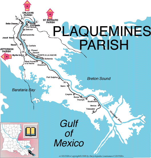
Plaquemines Parish |
Click RIGHT mouse button for
Controls.
(Coming to) America
- Neil Diamond
Timeline |
|
| 1507 | Almost 500 years ago, in 1507, a cartographer on one of Christopher
Columbus' expeditions to the Gulf of Mexico drew a map showing a huge river flowing from
the heart of North America. It was the Mississippi, and in charting its mouth the
cartographer became the first man to locate the area of Plaquemines Parish on a map.
From that moment the Mississippi River has played a significant part in the history
of America, and Plaquemines Parish has shared in this prominence. The mighty Father
of Waters became a gateway to the New World's fabulous wealth and paved the way to the
development of a great civilization. The name, Plaquemines, comes from an Indian word, piakimin, meaning persimmon. It was first used by Iberville and Bienville to name an old military post on the banks of the Mississippi which was surrounded by a large number of persimmon trees. Eventually the name was applied to the entire parish. Many expeditions were sent to find the river and explore the country it drained, but for more than a hundred years, the river was to remain little more than a crooked line on the inaccurate maps of the times. Finally, in 1682, Rene Robert Cavalier, Sieur de La Salle, led an expedition to the mouth of the river. On April 9, he planted a cross on the west bank somewhere between Venice and Head of Passes, proclaiming for France all of the Mississippi Valley and the area drained by tributaries of the river. He named it Louisiana in honor of France's King Louis XIV. |
| 1699 | This claim to the interior of the continent was strongly contested by Spain and England, but a chance meeting at one of the bends in the river upstream from Pointe-a-la-Hache solidified France's claim to the country. The area is called English Turn, because it was there, in 1699, that a British man-of-war, headed inland, reversed its course and returned to the Gulf, leaving Louisiana to the French. It seems the captain met the Frenchman, Bienville, coming downstream in a small boat. Bienville told the captain that France had built a strong fort just up the river. Of course this was a lie, but it was more than a century later before the British tried to claim it again. |
| 1700 | The next year, Bienville and Iberville established the first fortification near Phoenix and called it Fort Mississippi. Later, two military installations were built just below the present site of Triumph. Fort Jackson on the west bank, and Fort St. Philip, right across the river, saw heavy action in the War of 1812 and during the Civil War. |
| 1709 | Plaquemines Parish was first settled at English Turn in 1709 by the French brothers, Carriere. These hardy folk and other early settlers planted indigo, rice and sugar cane, grew oranges (introduced in 1750), fished the Gulf for shrimp and oysters, and lived a secluded but most pleasant life along the river's banks. Upriver, near New Orleans, the parish broadens and fertile land extends quite a distance from the river. Even before the Louisiana Purchase, large and beautiful plantations were built and the planters of area contributed very prominently in the development of Louisiana. The parish was created in 1807 from the County [sic] of Orleans, and Pointe a la Hache, one of the largest settlements between English Turn and the Gulf, was selected as the parish seat in 1846. |
| 1805 | When the Territory of Orleans is divided into counties [sic] the present-day Plaquemines Parish is part of Orleans County [sic]. |
| 1808 | Fort St. Leon in Belle Chasse, on the west bank of Plaquemines Parish, is rebuilt by Latour and garrisoned to defend New Orleans. The fort is destroyed by Adm. Farragut during the Civil War in the Union’s advance up the river. |
| 1822 | Fort Jackson, built around 1822-32, near Venice to protect the lower river. Named for Andrew Jackson. 1862 - Fort withstood 10 day siege by Farragut and surrendered after city fell. In 1898 and 1917-18, used as training base. 1961 - Fort was declared a national monument. |
| 1815 | Two historic military battles occurred in the parish: the failed attempt by the British navy in 1815 to neutralize Fort St. Philip and coordinate the attack against Andrew Jackson in Chalmette; and the Civil War battle in 1862, when Captain David Farragut's Union fleet fought its way past Fort St. Philip and Fort Jackson to capture New Orleans. This second military battle was a serious blow to the Confederacy. |
| 1844 | Plaquemines Parish received national notoriety in the Polk-Clay presidential election of 1844, when the parish gave Polk a majority of 970 where only 272 voters had been listed in the preceding census. It was charged that Judge Leonard, a Plaquemines politician acting under the orders of John Slidell, chartered two boats at New Orleans, put 350 men on board, and carried them to Plaquemines to vote for Polk. Although the Pennsylvania vote really carried the election for Polk, the so-called Plaquemines Frauds gave him a majority in Louisiana. Protests, both local and nation-wide, brought about an investigation by the state legislature, but no flagrant fraud was established against the Democrats, who claimed that the men were legally qualified voters who had been deprived of voting at New Orleans. |
| 1900 | In the twentieth century, Plaquemines Parish discovered another
abundance beneath the surface of the earth. Below the marsh and the shallow waters
of the Gulf, oil, natural gas and sulfur exist in such huge quantities that Plaquemines
has become one of the richest parishes in Louisiana. Sulfur was found at Lake
Washington and Grande Ecaille in 1932, and within four years over a quarter-million long
tons were being produced there. Millions of barrels of oil and cubic feet of natural
gas have flowed from wells in the Gulf and the marsh around the parish. Until the twentieth century, the low-lying lands of Plaquemines Parish were frequently damaged by floods and hurricanes. In this century, nature's ravages has been reduced to a minimum through federal flood control measures, better building codes and successful evacuation plans of the residents. The heritage of the parish is primarily French, Italian and Slavic. Yugoslav immigrants settled here in the late 19th century. Although the parish has no incorporated communities, unincorporated areas line both banks of the river. The principle communities are Pointe a la Hache, Belle Chasse, Buras and Triumph. Pointe-a-la-Hache, the parish seat, is located on the east bank of the Mississippi River, about fifty miles below New Orleans. The first church in the town was built in 1820, the jail in 1835, and the present courthouse in 1890. The first newspaper in the parish, The Rice Planter, was published at Pointe a la Hache during the decade preceding the Civil War. Belle Chasse is a thriving west bank community, about seven miles down the river from New Orleans. It has immediate access to the urban amenities of New Orleans and Jefferson Parish, yet retains its rural atmosphere. Buras, the orange center of the parish, existed as several tiny settlements with no name until 1840, when seven [sic] brothers of the Buras family moved from France and settled in the area. The community of Triumph is a smaller version of Buras. [Incorrect data re the Burat brothers - EBD.] |
| 1986 | In 1986, voters elected to change the parish's government from the commission council system, which had run it since 1960, to a president council. |
State Historical Markers |
English Turn |
|
So named because in this bend, 1699, Bienville, coming downstream, met the British who had come up river to choose site for a settlement. Bienville convinced Captain Lewis Banks that the territory was in possession of the French. Early concessions were established in the vicinity. |
|
Located in Braithwaite, District 2, Hwy 39, Plaquemines Parish. |
110 |
Fort de la Boulaye |
|
First white settlement in present day Louisiana, erected by Bienville in 1699 on this spot (then the bank of the Mississippi), prevented Britain’s seizure of the Mississippi Valley. |
|
Located in Phoenix, LA, Hwy 39, District 2, Plaquemines Parish |
6 |
Fort Jackson |
|
Built around 1822-32 to protect the lower river. Named for Andrew Jackson. 1862 - Fort withstood 10 day siege by Farragut and surrendered after city fell. In 1898 and 1917-18 used as training base. 1961-Fort was declared a national monument. |
|
Located in Venice, District 2, Hwy 23 Plaquemines Parish. |
134 |
Fort St. Leon |
|
Designed by De Verges and garrisoned in 1754, but abandoned in 1792. Because of strategic value it was rebuilt by Latour in 1808 and garrisoned to defend New Orleans; Destroyed by Adm. Farragut during Civil War in advance up river. |
|
Located in Belle Chasse, District 2, River Road, Parish. Plaquemines Parish. |
181 |
Venice |
|
Near this site on April 9, 1682, LaSalle claimed Louisiana for France. Father Zenobius Membre, a member of the expedition, sang the Te Deum. On March 3, 1699, Father Anastase Douay, a member of Iberville’s expedition, celebrated the first mass of record in French Louisiana. |
|
Located in Venice, LA, Dist. 2, Hwy 23 , Plaquemines Parish. |
88 |
Communities |
There are no incorporated communities in Plaquemines Parish. |
Unincorporated areas of interest in the parish
include: |
Unincorporated areas of interest in the parish include: Alliance, [Bayou Cane], Belair, Belle Chasse, Belvue, Benjamin Switch, Bertrandville, Bohemia, Boothville, Braithwaite, [Bremond], Buras, Burbridge, Burrwood, Carlisle, Cedar Grove, Dalcour, Davantto, Deer Range, Duvic, Empire, [Encalade], English Turn, [Foster's Canal], Gloria, Greenwood, [Gulftown], Happy Jack, Harlem, [Hesperides], [Homeplace], Ironton, Jesuit Bend, Junior, Linwood, Live Oak, Myrtle Grove, [Nairn], Naomi, Nero, [Nestor], Oak Point, Oakville, [Olga], Ollie, [Orchard], [Ostrica], Phoenix, [Pilot Town], [Point Celeste], [Pointe-a-la-Hache], Port Eads, Port Nickel, Port Sulphur, Promised Land, Reussite, [Saint Rosalie], Scarsdale, Scocola, St. Rosalie, Star, Stella, St. Leon, Sunrise, Tidewater, Triumph, Tropical Bend, Venice, Victory Switch, West Pointe a-la-Hache, Wills Point and Woodland. |
 |
Source: Encyclopedia Louisiana.
Background graphic created by Delrie Designs©