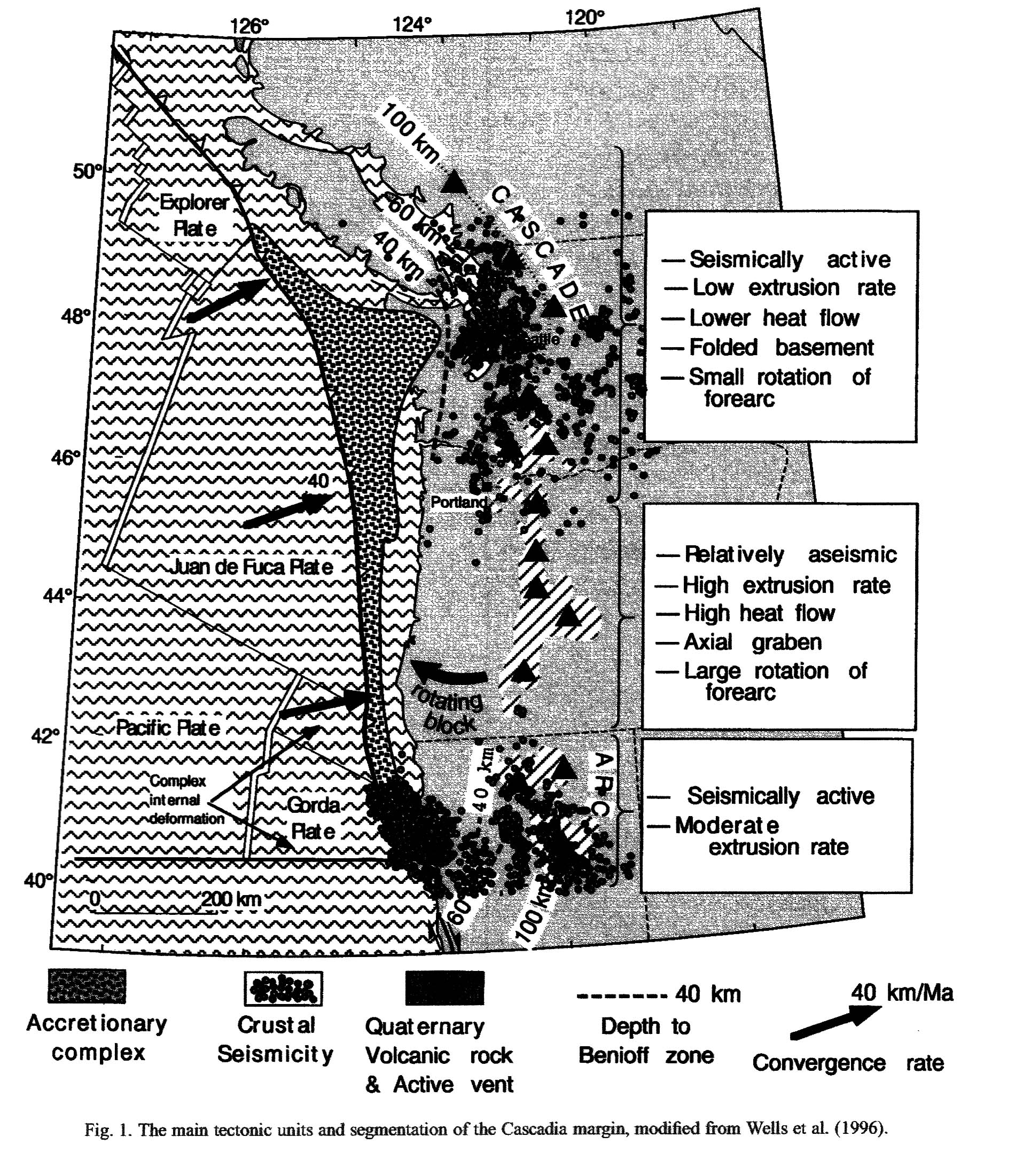
|
|||||||||||||
| Figure 2 Two details showing the variation in the reflection character at the subduction thrust. a, Thin (< 2 km) reflection response from the subduction thrust below line 89-06. The thrust is probably represented by a single reflection or a thinner reflection zone (<0.5 km) but the deconvolution was not able to remove the ringing and the stacking was not optimal, passing only the very low part of the signal spectrum. b, Thick (>4 km) band of reflections imaged on the most southern Vancouver Island line 84-02 overlies the subducted oceanic crust. In the initial Lithoprobe sections this thick, strong and landward dipping reflection band was named the 'E-layer' because it lies below a series of shallower reflections (A?D)10. To be compatible with the early interpretations we keep the name but in this work 'E' stands for 'electrically highly conductive'.� (NEDIMOVI | |||||||||||||
| Figure 2 is illustrating the reflection data at the Cascadia subduction zone. | |||||||||||||
| Figure 3 Example record sections showing the low-velocity zone. Shot?receiver geometries are marked on Fig. 1. A bandpass filter and a static topography correction have been applied to each record for display purposes. a, Straight line receiver gather. The first-arrival Pg phase is abruptly terminated at a range of 13 km from the receiver. At greater distances, the first significant arrival is delayed by 0.5 s. This phase corresponds to energy refracting through the deeper parts of the low-velocity zone. A similar shadow zone is observed on numerous shot?receiver geometries which cross the caldera. Rays with ranges > 13 km pass unaffected above the low-velocity zone. This record demonstrates that the low-velocity zone begins at depth beneath the caldera, and does not extend into the shallowest crust. b, Fan shot receiver gather. Shot?receiver ranges are 20?29 km (too close for PmP Moho reflection in the region). Times have been adjusted for range. The effect of the low-velocity anomaly is evident in the centre of the record. First-arrival Pg phases are clear for rays which pass to either side of the caldera region: shots at | |||||||||||||
| 0?13 km and 23?40 km on this plot. Between 13 and 26 km, this phase becomes delayed and quickly falls below the noise level. A strong second arrival is visible with a delay of | |||||||||||||
| 0.5 s. This large-amplitude phase is the same one found on record a at ranges > 13 km. This record reveals the lateral extent of the low-velocity zone. Thick black lines indicate modelled traveltimes. Time axes are reduced by 7 km s-1 for display purposes (West et al. 2001). | |||||||||||||
| Figure 3 is illustrating another image of the reflection profiles that can be found with the Cascadia subduction zone. | |||||||||||||
| Figure 4 | |||||||||||||
| Figure 4 Two reflection transects across the northern Cascadia subduction zone. a, The 160-km-long NE-trending transect comprises profiles 85-01 and 84-01. b, The 220-km-long SE-trending transect comprises profiles 85-05, JDF1 and JDF3b. The presented images are time-migrated stacks. All except the 1985-01 image were converted to depth along vertical rays. Data from various campaigns were acquired using different equipment and were differently processed, resulting in non-uniform images. Only the depth or time range of interest is shown. P-wave tomographic velocities24, extracted from a 3D velocity volume covering much of the study area, are shown as colour background for profiles 84-01, JDF1 and JDF3b. The tomographic velocities were computed by simultaneously inverting first P-wave arrivals from both the SHIPS 1998 wide-angle data set7 and a selected earthquake data set24. Relocated seismicity from 50-km-wide swaths centred on the profiles is projected on the reflection images and is shown as circles whose size corresponds to earthquake magnitude (1.0?4.6). The | |||||||||||||
| 1-s pull-up structure at about 40?50 km on line 85-01 is caused by a large lateral velocity change at the boundary between the Eocene fossil trench and the Pacific Rim terrain, located further landward. Sediments in the fossil trench are more than 3 km ( | |||||||||||||
| 2.3 s) thicker than over the neighbouring Pacific Rim terrain, and show significantly lower average velocities ( | |||||||||||||
| 3 km s-1)28 than the rocks of the Pacific Rim terrain (5.25 km s-1)29 (NEDIMOVI | et al. 2003). | ||||||||||||
| Figure 4 is illustrating two reflection transects across the northern Cascadia subduction zone, which is near Washington and British Columbia. | |||||||||||||
| Figure 5 | |||||||||||||
| Figure 5 Locked seismogenic, transition, and stable slipping sections of the northern Cascadia subduction interface. Sections inferred from a, the extent and character of the subduction thrust reflections and b, thermal and dislocation studies5, and dislocation modelling of the 1999 slow slip event6. a, Reflection zone 1 is characterized by thrust reflections less than 2 km thick. Zone 3 has a reflection band immediately above the oceanic plate that is more than 4 km thick. Within zone 2, this reflection band thickens from <2 to >4 km. Three-dimensional geometry of the subducted slab was taken into account when plotting the extent of the reflection zones. Thin red lines are reflection profiles. Overlying thick orange, blue, and purple lines indicate respectively where thin thrust reflections, transition to thick E-reflection band, and fully developed E-layer were successfully imaged. Dashed lines with identical colour-code and thickness show areas where imaging was intermittent. b, The location of the downdip thermal limit for seismogenic behaviour, inferred to be about 350 �C from laboratory and field studies, has been estimated from numerical modelling across the Vancouver Island margin5. The landward limit of the locked zone has been estimated by matching the predicted vertical and horizontal deformation from elastic dislocation models for a locked fault, to observations of repeated levelling surveys, global positioning system and other geodetic data6,30. (NEDIMOVI | |||||||||||||
| et al. 2003). | |||||||||||||
| Figure 5 is illustrating the relative positions of the locked seismogenic, transition, and stable slipping section of the northern Cascadia subduction zone.� | |||||||||||||