| 30 July 1999. Minnesota, Wisconsin. Downbursts and Straight Line Wind Event |
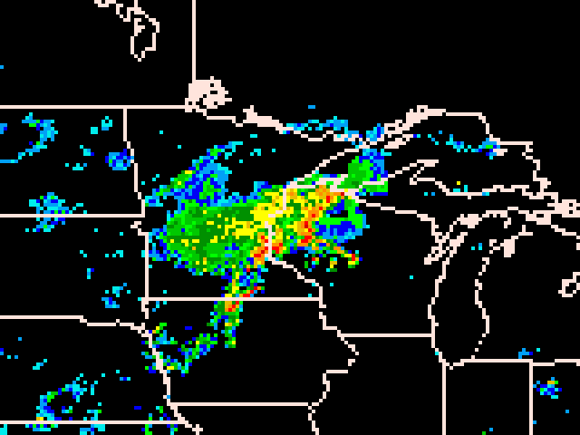
| Radar Mosaic at 5pm CDT. |
| 5:04pm Whitehall, Trempealeau Co: Large trees blown down. 5:06pm Whitehall, Trempealeau Co: Large trees blown down. 5:58pm Danbury, Burnett Co: Trees down. 6:03pm Wascott, Douglas Co: Trees and powerlines down. 6:23pm Minong, Washburn Co: Trees down. 6:30pm Drummond, Bayfield Co: 1 inch Hail 6:30pm Cable, Bayfield Co: 1 inch Hail 6:32pm Trego, Washburn Co: Trees and powerlines down. Roofs blown off. 6:32pm Spooner, Washburn Co: Trees and powerlines down. Roofs blown off. 6:40pm Grandview, Bayfield Co: Trees and powerlines down. 6:40pm 5 N River Falls, St. Croix Co: 0.75 inch hail. 6:45pm Hayward, Sawyer Co: Trees and powerlines down. 6:55pm Marshfield, Wood Co: Tree down on powerline. 6:58pm 6 W Barnes, Douglas Co: Trees Down. |
 |
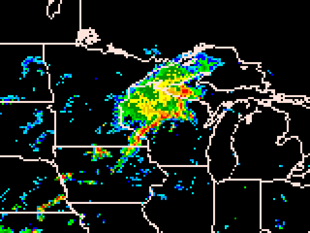
| Radar Mosaic at 7pm CDT. |
| 7:15pm Mellen, Ashland Co: Trees down. 7:15pm Ladysmith, Rusk Co: Roof off house. Trees down. 7:25pm Glidden, Ashland Co: Trees and powerlines down. 7:25pm 5 NW Maiden Rock, Pierce Co: Large branches down blocking road. 7:25pm 2 N Hawkins, Rusk Co: 18 inch diameter trees felled. 7:30pm Upson, Iron Co: Trees and powerlines down. 7:32pm 10 E New Auburn, Chippewa Co: Few trees down. 7:32pm Mosinee, Marathon Co: Trees and powerlines down. 7:38pm Loretta, Sawyer Co: Trees and powerlines down. 7:44pm Wausau, Marathon Co: 63 mph wind gust. Trees and powerlines down in Wausau, Rib Mountain, Rothschild, Schofield. 7:45pm 5 SW Phillips, Price Co: 87 mph wind gust. Trees and powerlines down. 8:00pm Saxon, Iron Co: Trees Down. 8:00pm Montreal, Iron Co: Trees Down. 8:15pm 5 NW Merrill, Lincoln Co: 4 trees down on Highway 107. 8:15pm Prentice, Price Co: 75 mph wind gust. Trees and powerlines down. Semi trailer overturned on Hwy 13. LP tank ruptured. 8:15pm Catawba, Price Co: Barn blown down. 8:20pm 1 SE Eau Claire, Eau Claire Co: Few trees down. 8:20pm Hazelhurst, Onedia Co: Trees down on Highway 51. All major roads in Onieda county closed or blocked by fallen trees after storm. 8:20pm Woodruff, Onieda Co: *** 1 Dead *** Tree fell on vehicle. Pregnant woman killed. 8:20pm Hazelhurst, Onedia Co: Falling tree damaged the Bengal Tiger cage at the Warbonnet Zoo, allowing two tigers to breifly escape. 8:20pm Manitowish, Iron Co: Trees and powerlines down. 8:27pm Lake Tomahawk, Oneida Co: 70 mph wind gust. 8:35pm Harrison, Lincoln Co: Trees down across road. 8:38pm St. Germain, Vilas Co: Numerous trees down... some on houses and garages. 8:49pm 8 W Stetsonville, Taylor Co: Barn blown down. 8:55pm Eagle River, Vilas Co: 67 mph wind gust. Numerous large trees down. |
 |
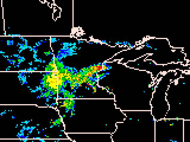
| Radar Mosaic at 9pm CDT. |
| Reports of large hail started at 2:20pm from the Minnesota counties of Morrison, Sterans, and Lac Qui Parle; the hail ranging in size from 0.75" to 1.5". Wind damage was reported at 3:00p in Swift county that flattened trees and corn with some fields a total loss. Five funnel clouds were sited from 3:45pm to 6:02pm in Swift, Meeker and Sibley counties. At 6:09pm the first tornado was sited in the Minnesota county of Scott, when spotters reported multiple tornadoes. At 6:11pm the next tornado was reported on the edge of Carver and Scott counties. The storms then moved across almost of all of Wisconsin throughout the night before crossing over the water of Lake Michigan. The map on the right: counties that are grey denote areas that reported damage, large hail, or high winds. Highest wind gust: 87 mph in central Price county. Fataliteis: One pregnant woman crushed in vehicle by tree in Oneida Co. The following is a timeline of WI damage reports and radar images. |
| 9:00pm Owen, Clark Co: Large trees blown down. 9:00pm Arcadia, Trempealeau Co: 60 mph wind gust. 9:15pm Crandon, Forest Co: Tree down on a garage and powerlines. 9:15pm Alvin, Forest Co: Trees down at Stevens Lake Campground. 9:25pm Long Lake, Florence Co: 1 foot diameter tree down. 9:30pm Mountain, Oconto Co: Tree down on powerline. 9:35pm Pickerel, Langlade Co: Wires down at Pickerel and White Lake. 9:50pm Dunbar, Marinette Co: Tree down. 9:50pm Spread Eagle, Florence Co: Trees and powerlines down... some on houses. 10:00pm Vesper, Wood Co: Tree down on powerlines. 10:15pm Tomah, Monroe Co: Large tree branches snapped. 10:20pm Keshena, Menominee Co: Couple trees fell on house. A few other trees down across the rest of the county. 10:27pm Fond du Lac, Fond du Lac Co: 69 mph wind gust. 10:28pm Fremont, Waupaca Co: 62 mph wind gust. Several trees and powerlines down. 10:30pm 6 SW Shawano, Shawano Co: Tree down on a house near Cloverleaf Lake. 10:30pm Klondike, Oconto Co: Tree down. 10:37pm Wausaukee, Marinette Co: Wires down. 10:43pm 1 N Wild Rose, Waushara Co: Tree down. 10:45pm Jericho, Calumet Co: Trees and powerlines down. 10:50pm Chilton, Calumet Co: Numerous trees and powerlines down. 11:00pm Hobart, Brown Co: Tree down. 11:00pm Redgranite, Waushara Co: Few trees down in area. 11:06pm Peshtigo, Marinette Co: Tree down. 11:10pm Appleton, Outagamie Co: Trees and powerlines down in Appleton. 11:10pm 2 SW Reedsville, Manitowoc Co: Barn and outbuilding bown onto road. 11:11pm 2 N Oxford, Marquette Co: 1 Tree down. 11:12pm 13 NW Oshkosh, Winnebago Co: Tree down. 11:15pm 8 NE Green Bay, Brown Co: Several 10 inch diameter trees down. Flag pole snapped. Shingels off roof. 11:30pm Oshkosh, Winnebago Co: Tree down. 11:30pm Sturgeon Bay, Door Co: Trees and powerlines down in and south of Sturgeon Bay. 12:00am 2 NE Kiel, Manitowoc Co: Large trees down on road. 12:10am Manitowoc, Manitowoc Co: Tree down on house. 12:25am Greenbush, Sheboygan Co: Limbs and pwerlines down from outflow boundary winds. 12:30am Westfield, Marquette Co: 50 mph non-thunderstorm outflow boundary winds. 12:30am Sheboygan Falls, Sheboygan Co: Non-thunderstorm winds. Limbs and powerlines down due to outflow boundary winds. |
 |
 |
| Historic storm reports can be found at http://www.spc.noaa.gov. I printed the storm reports as they came available on-line the day after the storm. |
 |