 |
| nathan's local precipitation |
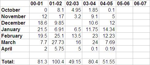
| Liquid Precipitation by month (inches) (rainfall + melted snowfall) |
| Snowfall Totals by month (inches) |
| My raingauge is located in a field/forest mix in a rural setting. I've kept daily records since 2000. The circled dot in the middle of the map is the location of my weather station at an elevation of 1560 ft. |
| Station Location |
 |
 |
| Forest - Green Field/Meadow - White |
 |
| This is my 4" NWS raingauge's outer cylinder. It can be used to measure core-samples of snow, which can be melted and then measured with the inner tube to determine the liquid equivalent. When you know the snow depth and the liquid equivalent, you can easily calculate a snow/water ratio. I also use the liquid equivalent to keep track of precipation amounts throughout the winter months. Snow depth in the picture is 8" and it is dated the 20th of March 2003. |
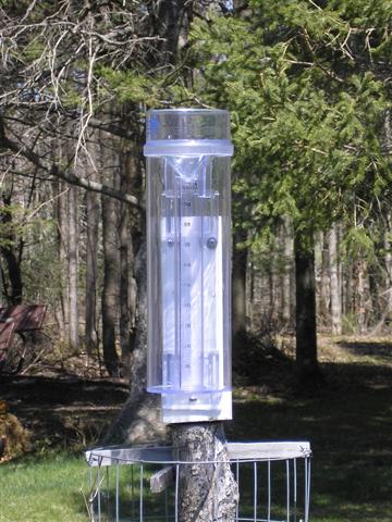 |
| This is my 4" NWS raingauge. The inner tube measures and holds up to 1 inch of rain with increments of 0.01". The outer tube can hold up to 10 more inches of rain if the inner tube overflows. My raingauge is mounted in the backyard, in the center of an opening between the trees and the house. I think it's the best I can do. It is mounted betwen 4 and 5 feet above the ground level. That is part of a circular wire trellis that I mounted to the post. The raingauge is checked and emptied at 7am and 7pm daily. That data is then recorded. |
| The Raingauge |
| My Precipitation Data |
| back to Weather nathan's local temperatures Wisconsin Averages & Extremes Vantage Pro Weather Station |
 |
| 2.83 |
| 36.82 |
| 8.76 |
| 2.65 |
| 1.19 |
| 4.97 |
| 7.69 |
| 2.52 |
| 0 |
| 12.81 |
| 75.95 |
| 1.33 |
| 1.38 |
| 30.166 |
| 13.5 |
| 13.63 |
| 13.38 |
| 1.18 |
| 3.44 |
| 0.81 |
| 22.63 |
| 0 |
| 0 |
| 2.76 |
| 1.03 |
| 6.90 |
| 4.155 |
| 2.115 |
| 1.61 |
| 1.041 |
| 0 |
| 1.75 |
| 3.745 |
| 6.75 |
| 7.5 |
| 11 |
| 27.00 |
| 0.65 |
| 0.99 |
| 1.64 |