 |
| Great Lakes: Lake Superior |
| nathan's Photo Album |
| Madeline Island Apostle Islands National Lakeshore. South Shore of Lake Superior Wisconsin and Michigan shoreline. Superior Falls On the Montreal River, WI/MI. |
| <<< Cheq-Nic NF Photo Album Door Co., WI >>> |
 |
| Lake Superior from space. Left is north, top is east, bottom is west, right is south. The white are clouds. Canada on the left. United States on the right. |
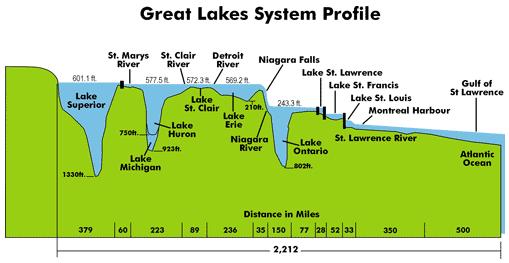
| Average water temperature: 40 degrees F. Maximum wave height recorded: 31 feet. Shoreline Length: 2726 miles. Deepest spot: 1,332 feet. Water replacement time: 191 years. Elevation: 600 ft amsl. Froze over completely: 1962, 1979, 2003 Average Ice-over interval: every 20 years |
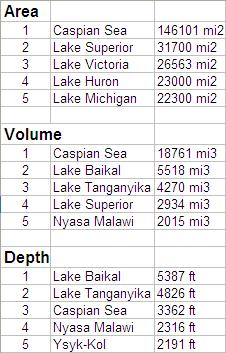
| Quick Facts: Lake Superior is the second largest freshwater lake in the world by surface area. Lake Superior is the fourth largest freshwater lake in the world by volume. (3,193 trillion gallons) Lake Superior is the largest of the Great Lakes in surface area and volume; Lake Superior is also the deepest. Lake Superior is 1332 feet deep (deepest of the Great Lakes). At least fifteen other lakes around the world are deeper. |
| Quick Facts: Lake Superior has 10% of surface freshwater in the world. Lake Superior could contain all the other Great Lakes plus three more lakes the size of Lake Erie. |
 |