| I have been posted to a village in the Lufwanyama District in the Copperbelt Province. I will have intermittent internet access during my assignment (my hut will not have electricty) and I will update my blog and read emails when I can. Cutoff for sending packages: 09 March 2007 Cutoff for sending letters: 01 May 2007 This address is where I can pick up mail while at post. |
 |
| mission: Peace Corps ZAMBIA |
| my Peace Corps assignment: LIFE (linking income food and the environment): Forestry Extension Agent Zambia 5.26.2005 to 6.29.2007 |
| Former Name: Northern Rhodesia Capital: Lusaka (1.3 million people) Coordinates 15.7 S 28.483 E Average Elevation: 4000 feet amsl Population: 10,462,436 about the same as Michigan Area: 290,585.9 sq mi about the size of Texas Climate: Moderated Tropical with three seasons: 1) Warm & Wet - Nov to April 2) Cool & Dry - May to August 3) Hot & Dry - Sept to October |
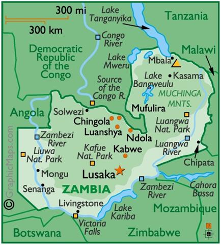 |
| Above: Kitwe is just a little north of Luanshya. The lighter color along the west and southern borders are the Zambezi/Luangwa River valleys, while the light green color in the center of the country is the high plateau. This higher elevation reduces the humidty. |
| * Mail takes 2-4 Weeks (one way) between US and Zambia. -Approximately 2 weeks for airmail to get to Zambia and 3 weeks to get from Zambia to the U.S. * The most secure method of mail is AIR MAIL - Write "Air Mail" and "Par Avion" on the envelope. - Number letters in sequence. * Sometimes packages/letters might get lost or stolen. -From speaking to previous & current PC volunteers, they have never had a package or a letter stolen. * Some items shipped may require me to pay an import tax on it. -For now, there appears to be no import duties required. * Keep in mind, packages may be opened and rifled through. If you put "Religious Items Enclosed" on the package, it's much less likely to be bothered. Zambia is a poor but very religious country. |
| Peace Corps Volunteer Nathan Kilger St. Marys Mission P.O. BOX 20342 Kitwe, Zambia, C. Africa |
| Miles from the equator: 1074 miles Miles from Butternut, WI to the equator: 3174 miles (three times farther) Distance b/w Butternut & Zambia: 8368 miles (1/3rd of the way around Earth) Official Language: English Goverment: President & Vice President Unicameral Legislature Independence from the UK: 24 October 1964 Currency: Zambia Kwacha Highest Point: Mafinga Hills 7549 feet amsl Lowest Point: Zambezi River 1079 feet amsl |
| Symbolism of the Flag Green - the agriculture Orange - the country's copper Red - the struggle for freedom Black - the people source |
 |
|
|
 |
| Lusaka, Zambia forecast |
| Time Central African Timezone (no daylight savings time) UTC + 2hrs CST + 8hrs CDT + 7hrs 12:00pm CST = 8:00pm Zambian Local Time 12:00pm CDT = 7:00pm Zambian Local Time |
| current time: |
| News Times of Zambia Zambia News Maps Maps of Zambia Geography.com Information WorldAtlas.com Zana about Zambia |
 |
| LIFE: This project promotes the conservation of wildlife to enhance and sustain the economic benefits of tourism. Target populations are those living in Game Management Areas that adjoin national parks. Volunteer efforts are directed to local infrastructure capacity building, environmental eduation and livelihood security as an alternative to poaching wildlife and planting crops in national parks. |
| Peace Corps Zambia -- US Embassy in Lusaka Zambia Peace Corps Zambia -- Peace Corps online.org |