 State-Wide Uniform Marking of Arterial County Highways
Background and purpose
Ohio's state highway system is really not a bad system. That said, neither are most of the county road systems across the state. Scattered about are county roads that make good routes for a very few who take the time to research the local roads on the way. Many maps of the state include county highways that make perfectly good regional arterials, but these roads have names simply too long to display on most state maps. Some of them even change names multiple times, but can be drawn as one line on the map. Not to mention how poorly marked the county roads can be compared to state highways.
To make regional navigation off of the state highway system a bit easier, I propose a simpler way to identify these regional-arterial county highways. With route codes consisting of either two letters or a letter and a number (either of which can come first) and not including the number zero, there are 1,144 such codes possible. Divided among Ohio's 88 counties, each county gets 13 routes to assign. These routes will have a uniform marking system similar to the state highways. Routes can multiplex with state and U.S. non-freeway highways if necessary, and should not end at county boundaries. Extension of a county's SWUMACH routes into neighboring counties is encouraged, both to aid connectivity and to promote longer routes and route code conservation. Lastly, four historic roads have reserved route codes: the Lincoln Highway (LH), National Road (NR), Dixie Highway (DH), and Zane's Trace (ZT). Old, but still passible, alignments of these roads should be marked with these route codes.
Route Code Allocation
| Adams |
1Q | 2Q | 3Q | 4Q | 5Q | 6Q | 7Q | 8Q | 9Q | BQ | DQ | EQ | TQ |
How the codes were allocated
This allocation of 1,144 route codes among 88 counties is not set in stone, but it would be a pain in the neck to change. I have painstakingly allocated and reallocated codes to fit the following criteria:
Each county has a common letter in all of its codes, and that common letter is in the same position in all of that county's codes.
The common letter is, when possible, the first (or other prominent) letter in the county's name, or in the name of a city or other major feature in the county.
Counties with higher populations get codes that make more sense. Only a handful of counties were given codes based solely on availability.
Codes reserved for historical routes are assigned to counties through which such routes pass. |
| Allen |
A1 | A2 | A3 | A4 | A5 | A6 | A7 | A8 | A9 | AA | AB | AC | AD |
| Ashland |
IA | JA | KA | LA | MA | SA | TA | UA | VA | WA | XA | YA | ZA |
| Ashtabula |
AG | AH | AN | AO | AP | AQ | AR | AT | AU | AV | AX | AY | AZ |
| Athens |
1A | 2A | 3A | 4A | 5A | 6A | 7A | 8A | 9A | EA | FA | GA | HA |
| Auglaize |
KK | KL | KM | KN | KO | KQ | KR | KT | KU | KV | KX | KY | KZ |
| Belmont |
1B | 2B | 3B | 4B | 5B | 6B | 7B | 8B | 9B | EB | FB | GB | HB |
| Brown |
1O | 2O | 3O | 4O | 5O | 6O | 7O | 8O | 9O | BO | DO | EO | TO |
| Butler |
B1 | B2 | B3 | B4 | B5 | B6 | B7 | B8 | B9 | BA | BB | BC | BD |
| Carroll |
Q1 | Q2 | Q3 | Q4 | Q5 | Q6 | Q7 | Q8 | Q9 | QA | QB | QC | QD |
| Champaign |
UG | UH | UN | UO | UQ | UR | US | UT | UU | UV | UX | UY | UZ |
| Clark |
1C | 2C | 3C | 4C | 5C | 6C | 7C | 8C | 9C | EC | FC | GC | HC |
| Clermont |
CH | CN | CO | CP | CQ | CR | CT | CU | CV | CW | CX | CY | CZ |
| Clinton |
1G | 2G | 3G | 4G | 5G | 6G | 7G | 8G | 9G | BG | CG | DG | IG |
| Columbiana |
IC | JC | KC | LC | MC | RC | TC | UC | VC | WC | XC | YC | ZC |
| Coshocton |
OM | ON | OO | OP | OQ | OR | OS | OT | OU | OV | OX | OY | OZ |
| Crawford |
Y1 | Y2 | Y3 | Y4 | Y5 | Y6 | Y7 | Y8 | Y9 | YB | YD | YI | YJ |
| Cuyahoga |
C1 | C2 | C3 | C4 | C5 | C6 | C7 | C8 | C9 | CA | CB | CC | CD |
| Darke |
1D | 2D | 3D | 4D | 5D | 6D | 7D | 8D | 9D | ED | GD | HD | TD |
| Defiance |
EK | FK | GK | HK | MK | NK | OK | PK | QK | RK | SK | TK | UK |
| Delaware |
D1 | D2 | D3 | D4 | D5 | D6 | D7 | D8 | D9 | DA | DB | DC | DD |
| Erie |
E1 | E2 | E3 | E4 | E5 | E6 | E7 | E8 | E9 | EE | EF | EG | EH |
| Fairfield |
FH | FN | FO | FP | FQ | FR | FS | FU | FV | FW | FX | FY | FZ |
| Fayette |
IF | JF | KF | LF | NF | OF | PF | QF | VF | WF | XF | YF | ZF |
| Franklin |
F1 | F2 | F3 | F4 | F5 | F6 | F7 | F8 | F9 | FD | FE | FF | FG |
| Fulton |
1F | 2F | 3F | 4F | 5F | 6F | 7F | 8F | 9F | AF | BF | CF | DF |
| Gallia |
JG | KG | LG | NG | OG | PG | QG | TG | VG | WG | XG | YG | ZG |
| Geauga |
GN | GO | GP | GQ | GR | GS | GT | GU | GV | GW | GX | GY | GZ |
| Greene |
G1 | G2 | G3 | G4 | G5 | G6 | G7 | G8 | G9 | GE | GF | GG | GH |
| Guernsey |
NM | NN | NO | NP | NQ | NR | NS | NT | NU | NV | NX | NY | NZ |
| Hamilton |
H1 | H2 | H3 | H4 | H5 | H6 | H7 | H8 | H9 | HE | HF | HG | HH |
| Hancock |
KH | LH | NH | OH | PH | QH | SH | TH | VH | WH | XH | YH | ZH |
| Hardin |
1K | 2K | 3K | 4K | 5K | 6K | 7K | 8K | 9K | AK | BK | CK | DK |
| Harrisson |
1X | 2X | 3X | 4X | 5X | 6X | 7X | 8X | 9X | BX | DX | EX | TX |
| Henry |
EJ | FH | GH | HJ | MJ | NJ | OJ | PJ | QJ | RJ | SJ | TJ | UJ |
| Highland |
1R | 2R | 3R | 4R | 5R | 6R | 7R | 8R | 9R | BR | DR | ER | TR |
| Hocking |
QM | QN | QO | QP | QQ | QR | QS | QT | QU | QV | QX | QY | QZ |
| Holmes |
IE | JE | KE | LE | NE | OE | PE | QE | VE | WE | XE | YE | ZE |
| Huron |
HN | HO | HP | HQ | HR | HS | HT | HU | HV | HW | HX | HY | HZ |
| Jackson |
JK | JL | JM | JN | JO | JQ | JR | JT | JU | JV | JX | JY | JZ |
| Jefferson |
J1 | J2 | J3 | J4 | J5 | J6 | J7 | J8 | J9 | JB | JD | JI | JJ |
| Knox |
K1 | K2 | K3 | K4 | K5 | K6 | K7 | K8 | K9 | KB | KD | KI | KJ |
| Lake |
1L | 2L | 3L | 4L | 5L | 6L | 7L | 8L | 9L | AL | BL | CL | DL |
| Lawrence |
I1 | I2 | I3 | I4 | I5 | I6 | I7 | I8 | I9 | IB | ID | II | IJ |
| Licking |
EL | FL | GL | HL | ML | NL | OL | PL | QL | RL | SL | TL | UL |
| Logan |
IK | IL | IM | IN | IO | IQ | IR | IT | IU | IV | IX | IY | IZ |
| Loraine |
LK | LL | LM | LN | LO | LQ | LR | LT | LU | LV | LX | LY | LZ |
| Lucas |
L1 | L2 | L3 | L4 | L5 | L6 | L7 | L8 | L9 | LB | LD | LI | LJ |
| Madison |
1I | 2I | 3I | 4I | 5I | 6I | 7I | 8I | 9I | AI | BI | CI | DI |
| Mahoning |
MG | MH | MM | MN | MO | MQ | MR | MT | MU | MV | MX | MY | MZ |
| Marion |
1N | 2N | 3N | 4N | 5N | 6N | 7N | 8N | 9N | BN | DN | EN | TN |
| Medina |
1M | 2M | 3M | 4M | 5M | 6M | 7M | 8M | 9M | AM | BM | CM | DM |
| Meigs |
1V | 2V | 3V | 4V | 5V | 6V | 7V | 8V | 9V | BV | DV | EV | TV |
| Mercer |
EI | FI | GI | HI | MI | NI | OI | PI | QI | RI | SI | TI | UI |
| Miami |
EM | FM | GM | HM | RM | SM | TM | UM | VM | WM | XM | YM | ZM |
| Monroe |
Z1 | Z2 | Z3 | Z4 | Z5 | Z6 | Z7 | Z8 | Z9 | ZB | ZD | ZI | ZJ |
| Montgomery |
M1 | M2 | M3 | M4 | M5 | M6 | M7 | M8 | M9 | MB | MD | ME | MF |
| Morgan |
1Z | 2Z | 3Z | 4Z | 5Z | 6Z | 7Z | 8Z | 9Z | BZ | DZ | EZ | TZ |
| Morrow |
1J | 2J | 3J | 4J | 5J | 6J | 7J | 8J | 9J | AJ | BJ | CJ | DJ |
| Muskingum |
ZK | ZL | ZN | ZO | ZQ | ZR | ZT | ZU | ZV | ZW | ZX | ZY | ZZ |
| Noble |
N1 | N2 | N3 | N4 | N5 | N6 | N7 | N8 | N9 | NA | NB | NC | ND |
| Ottowa |
O1 | O2 | O3 | O4 | O5 | O6 | O7 | O8 | O9 | OA | OB | OC | OD |
| Paulding |
XK | XL | XN | XO | XQ | XR | XT | XU | XV | XW | XX | XY | XZ |
| Perry |
X1 | X2 | X3 | X4 | X5 | X6 | X7 | X8 | X9 | XB | XD | XI | XJ |
| Pickaway |
PM | PN | PO | PP | PQ | PR | PS | PT | PU | PV | PX | PY | PZ |
| Pike |
1U | 2U | 3U | 4U | 5U | 6U | 7U | 8U | 9U | BU | DU | EU | TU |
| Portage |
P1 | P2 | P3 | P4 | P5 | P6 | P7 | P8 | P9 | PA | PB | PC | PD |
| Preble |
1P | 2P | 3P | 4P | 5P | 6P | 7P | 8P | 9P | BP | DP | EP | IP |
| Putnam |
JP | KP | LP | MP | RP | SP | TP | UP | VP | WP | XP | YP | ZP |
| Richland |
R1 | R2 | R3 | R4 | R5 | R6 | R7 | R8 | R9 | RA | RB | RD | RE |
| Ross |
RF | RG | RH | RN | RO | RQ | RR | RT | RU | RV | RX | RY | RZ |
| Sandusky |
ES | IS | JS | KS | LS | MS | RS | TS | VS | WS | XS | YS | ZS |
| Scioto |
1S | 2S | 3S | 4S | 5S | 6S | 7S | 8S | 9S | AS | BS | CS | DS |
| Seneca |
1E | 2E | 3E | 4E | 5E | 6E | 7E | 8E | 9E | AE | BE | CE | DE |
| Shelby |
1H | 2H | 3H | 4H | 5H | 6H | 7H | 8H | 9H | BH | DH | IH | JH |
| Stark |
SF | SG | SN | SO | SQ | SR | SS | ST | SU | SV | SX | SY | SZ |
| Summit |
S1 | S2 | S3 | S4 | S5 | S6 | S7 | S8 | S9 | SB | SC | SD | SE |
| Trumbull |
T1 | T2 | T3 | T4 | T5 | T6 | T7 | T8 | T9 | TB | TE | TF | TT |
| Tuscarawas |
1T | 2T | 3T | 4T | 5T | 6T | 7T | 8T | 9T | BT | DT | ET | FT |
| Union |
U1 | U2 | U3 | U4 | U5 | U6 | U7 | U8 | U9 | UB | UD | UE | UF |
| Van Wert |
V1 | V2 | V3 | V4 | V5 | V6 | V7 | V8 | V9 | VB | VD | VI | VJ |
| Vinton |
VK | VL | VN | VO | VQ | VR | VT | VU | VV | VW | VX | VY | VZ |
| Warren |
W1 | W2 | W3 | W4 | W5 | W6 | W7 | W8 | W9 | WB | WD | WI | WJ |
| Washington |
IW | JW | KW | LW | MW | NW | OW | PW | QW | RW | SW | TW | UW |
| Wayne |
1W | 2W | 3W | 4W | 5W | 6W | 7W | 8W | 9W | AW | BW | DW | EW |
| Williams |
1Y | 2Y | 3Y | 4Y | 5Y | 6Y | 7Y | 8Y | 9Y | BY | DY | EY | TY |
| Wood |
WK | WL | WN | WO | WQ | WR | WT | WU | WV | WW | WX | WY | WZ |
| Wyandot |
YK | YL | YN | YO | YQ | YR | YT | YU | YV | YW | WX | YY | YZ |
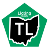
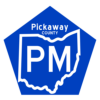
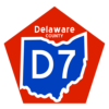
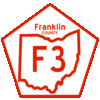
Possible Shield Designs
Design 1
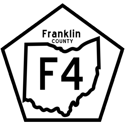 |
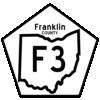
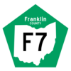
This design features shields which are pentagon-shaped in general, containing the county name above the shape of Ohio. The route code is contained inside the shape of Ohio. The route inside the shape of ohio is to impress that it's a statewide numbering system. The pentagon and the county label are to serve as reminders that the road still falls under county jurisdiction. |
Color Schemes
 |
 |
 |
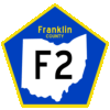 |
Here are 16 color schemes I have come up with initially, though many more are possible. An informal initial survey suggests that the black-on-white Ohio & route on the white-on-green pentagon and county name (shown at left for route F7) and the green-on-white-with-green-outline Ohio & route on the green-on-yellow pentagon and county name (shown at left for route U8) are the most appealing. Personally, I think that the former would go well in an urban environment, while the latter is better for rural areas, especially in the northwest quadrant of the state. The yellow-on-blue shield follows a common color scheme for county road signs, but bears great similarity to the colors for the University of Michigan, which can be a a turnoff to many Ohioans; hence, the red-on-white design. The black-on-white Ohio and route number with no border on the yellow-on-blue pentagon and county name seems to be a decent compromise between classic county road markings and urban style. Since different color schemes would be more aesthetically pleasing in different settings, allowing different counties (or municipalities) to use different colors might make sense, but this might serve to undermine the impression of state-wide uniformity. |
 |
 |
 |
 |
 |
 |
 |
 |
 |
 |
 |
 |
Copyright (c) 2004-05 David Smith.