 Local Columbus Roads LingoLocal Columbus Roads Lingo
Freeways are typically referred to by number, without the word "the." The 2-digit Interstates almost always have the "I-" prefix in speaking, while the use of the "I-" prefix for 3-digit Interstates is only sometimes used. The "IH-" prefix is never used. Non-interstate freeways are sometimes prefixed with the term "Route" before the number, and this practice is more common with 2-digit route numbers. "US-" and "State Route" prefixes are sometimes used when applicable, and more often in writing. It is not uncommon to refer to routes with their number alone, without any prefix or the word "the," especially in the case of 3-digit route numbers. In the city, US and state routes are usually referred to by their street name. Sometimes, a route's in-city name is used incorrectly to refer to the route outside of the city, such as High St for US-23 north and south of the city.
The "OH-" prefix for state routes is never used locally, and interchanges are usually not referred to by exit numbers, but I use them here for unambiguity and because it's more common for the roadgeek community, who is the intended audience of this page.
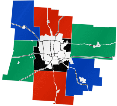
This is the ring of highways surrounding downtown. There is evidence that it has its own mileage logging, more info on this to come. The Innerbelt consists of segments of OH-315, I-670, I-71, and I-70/I-71. Those segments may sometimes be referred to individually as the West Innerbelt, North Innerbelt, East Innerbelt, and South Innerbelt, respectively, though naming them by their route number is much more common. When referring to the South Innerbelt by number, the prescence of I-71 there is often ignored in favor of I-70. In the early 1990's, the Innerbelt was in its original 1960s configuration. As of this writing, nearly half of it has been redesigned and rebuilt, and by the late 2010's, it should be completely modernized. The Innerbelt's speed limit is 55 MPH; all other freeways in Columbus are 65 MPH.
This is I-270, and it is NEVER called the Beltway by any locals. It is 55 miles around in case you were wondering. Directional indications are NORTH/SOUTH and EAST/WEST, changing at exits 5, 17, 30, and 46. At these interchanges, it is common to see entrance signage for I-270 in non-complementary directions such as EAST/SOUTH. INNER and OUTER are never used to indicate directions of clockwise and counterclockwise, as may be common in New England. Sometimes, specific stretches of the Outerbelt are referenced: the West Outerbelt, from exits 8 to 17; the North Outerbelt, from exits 17 to 30; the East Outerbelt, from exits 30 to 44; and the South Innerbelt, from exits 44 to 8. The latter quadrant was stigmatized in late 2003 and early 2004 when a serial sniper had a pattern of shooting at moving vehicles on the freeway. Officially, I-270 is the Jack Nicklaus Freeway, but this hasn't been signed in decades. Just north of exit 5, there are signs for both directions marking the freeway as the Trooper Frank G. Vasquez Memorial Highway, after a state trooper who was killed by a hit-skip driver while ticketing another motorist in 2003. Officially, this memorial designation extends from exits 5 to 8.
The Split usually is equivalent to the South Innerbelt. This usage (the only use of "split" referring to a stretch of freeway rather than a single interchange) is fairly recent, and became more common as the South Innerbelt study began. Prior to that, and still sometimes in traffic reports, the terminology "between the Splits" or "through the Splits" is common. When Splits is used in plural, it usually refers collectively to the East and West Splits. The East Split and the West Split refer to the east and west ends of the I-70/I-71 multiplex, respectively. Another Split in Columbus is the I-670 Split, referring to the junction of I-70 and I-670. This term is primarily used as a landmark in morning commute traffic reports.
I-70 east of downtown. Also known as East Expressway. Officially, the Veterans of Foreign Wars Memorial Highway and the Dwight D. Eisenhower Memorial Highway. This designation is only signed on freeway entrances from rural rest areas and is not used in traffic reports.
I-70 west of downtown. Also known as West Expressway. Officially, the Veterans of Foreign Wars Memorial Highway and the Dwight D. Eisenhower Memorial Highway. This designation is only signed on freeway entrances from rural rest areas and is not used in traffic reports.
I-71 north of downtown. Also known as North Expressway. Officially, the Disabled American Veterans Highway. This designation is not signed anywhere and not used in traffic reports.
I-70 south of downtown. Also known as South Expressway. Officially, the Disabled American Veterans Highway. This designation is not signed anywhere and not used in traffic reports.
I-670 east of downtown. Sometimes, this term refers to the entire length of I-670. Officially, the Theodore L. Wallace Memorial Highway west of exit 4. This designation is signed on a few entrances to the freeway, but never used in traffic reports.
OH-315 between downtown and I-270. Officially, the Moody Jackson Parkway. This designation is not signed anywhere and is not used in traffic reports.
US-33 east of I-70 exit 105A.
OH-161 east of I-270 exit 30. Also known as the New Albany Bypass.
US-33 between OH-161 and OH-315. East of Trabue Rd, the name of the road is actually Dublin Rd, but people call it Riverside Dr anyway. Many locals don't even know that this is US-33. (A few other numbered non-freeway routes have the same problem, but this one has it the worst.)
The OH-315 / W North Broadway interchange. Frequenly used as a landmark in traffic reports.
Two large water tanks on the north side of I-270, about a mile west of exit 22. Frequenly used as a landmark in traffic reports.
Exit 102 on I-70. Frequently used as a landmark in traffic reports.
A prominent curve in I-70 near exit 103. Frequently used as a landmark in traffic reports.
A proposed connecter between OH-315 and High St in the vicinity of Bethel and Morse Rds. Bethel Rd and Morse Rd align perfectly, but a direct connection across the Olentangy River was never made. West of High St, Morse Rd becomes Rathbone Rd, a residential street with many high-value properties. The OH-315 interchange with Bethel Rd was obviously constructed with intentions of building a direct connection -- including room for a WB-SB looping entrance ramp -- but the direct connection idea has consistently failed politically. A connector through nearby Graceland Shopping Center (a few blocks to the north of Morse Rd) has been proposed, but that connector would cut through a popular park. Graceland is being re-developed, but there is no indication of space reserved for a future connection to Bethel Rd and OH-315, despite the potential increase in commercial value for the property.
The Morse-Bethel Connector likely won't become a reality until cars can fly -- which I don't even expect in my lifetime or that of my grandchildren -- and even then there would probably be political opposition. I include it here not because of any chance of its existence, but because it's the most-talked-about failed road proposal in the city.
A nickname for Columbus used by AM-radio personality Jim Rome. This nickname is NOT used locally. Most area residents (I've asked around) think the nickname sounds stupid, but some concede that it's better than "Cowtown."
An old nickname for Columbus. This nickname was not intended to inply that Columbus is small, but referred to the city's former status as the "Gateway to the Midwest" and, as a result, a cattle-shipping hub. Much of the Midwest's cattle was shipped through Columbus on its way to the East Coast.
There is still some cattle interest in Columbus, mostly at the Ohio Expo Center, which hosts both the Ohio State Fair and the Ohio Quarter-horse Congress. The city is no longer a "cowtown" by any means, however. Some may characterize it as a "college town," but it is a very big college town, home to a very big college. Over one million people live in Franklin County, and Columbus suffers from many big-city problems. But I digress. Arguing that Columbus deserves the same respect as any big city should be the subject of another page.