|
Botolan |
||
|
|
|
|
|
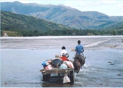
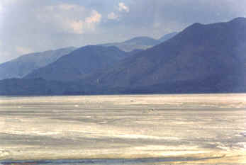
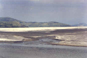
San Antonio is an unusually pretty town. It's like little suburbia, Filipino style. I didn't see anything that I would consider overt poverty here. Most people seemed to live in modest single family homes. I was also surprised to see a large number of retired expats living here and in the next town of San Narciso. The road north stays right on the coast almost the whole way to Botolan, but there are very few areas of undeveloped beach. Most of the land between the beach and the highway is occupied by homes and small businesses. However, there are a few places along the way where you can turn off onto a dirt road and park right on the beach. Botolan My main reason for going to Botolan was to see the lahar that flows down the Bucao River. According to the geological reports that I read, this was the largest lahar created by the Pinatubo eruption. These pictures are views across the lahar, over a mile in width in places. If you look at an old map of Luzon, you will see a road connecting Botolan to Capas (midway between Angeles and Tarlac). The eruption wiped out most of the road, however, you can still drive from Botolan along the river up toward Mt. Pinatubo. It is hard to believe that this valley, full of sand and ash, once used to be a thriving agricultural area. Also, along this road, you will encounter the resettlement camps created for the people that lost their homes and property during the eruption. I had also read of a Swiss man that was offering 4-wheel drive tours up the lahar during the dry season. Unfortunately, when we got there, his World War II vintage truck had suffered a terminal break down. There's not much to see in Botolan except the old cathedral that was built back in the 1890's and constructed out of dark coral blocks. Mavel always likes to stop in the old churches to offer a little prayer. Getting close to noon, we decided to drive around into Botolan to get something to eat, but we only found one place that could be considered a restaurant. Mavel looked into all the pots and pans and wouldn't have anything to do with it. So we drove 4 miles back south to a resort that we had passed along the way called Rama_Beach Resort . They served an excellent lunch at a decent price. The beach was very clean and almost deserted ... so was the hotel. Actually, the hotel was fine, I would have no problem spending an evening here. But given a choice, you are better off driving another 10 miles up to Iba Close to the Rama is another resort that is mostly a camp ground, but they have a few very large and modern apartments for rent. But they also wanted a fantastic price (P4000). Their restaurant was also very expensive. During our first trip to Zambales, Botolan was as far north as we drove. We just headed back to Baloy Beach. On our second trip to Zambales, we finally made it to Iba and up 100 Islands, but this time we flew from Angeles, over Mt. Pinatubo to Iba airport. If you haven't already seen our pictures of the Mt. Pinatubo flight, you can find them here: Or you can continue on to Iba . |
|
|