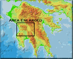
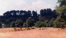
 Location: The great western plain of Arcadia stretches 30 km
from north to south and 16 km from east to west. Unlike most Greek cities,
Megalopolis therefore had no easily defensible heights, a situation similar
to Mantinea's. Although Mantinea was totally flat, Megalopolis did
have some irregular hills that were incorporated into the defensive walls
constructed with the city. The area was crossed by cool rivers draining
from the mountains of Arcadia which surround it and the farmland was better
than most in the region. The city itself was laid out on both sides
of the Helisson River.
Location: The great western plain of Arcadia stretches 30 km
from north to south and 16 km from east to west. Unlike most Greek cities,
Megalopolis therefore had no easily defensible heights, a situation similar
to Mantinea's. Although Mantinea was totally flat, Megalopolis did
have some irregular hills that were incorporated into the defensive walls
constructed with the city. The area was crossed by cool rivers draining
from the mountains of Arcadia which surround it and the farmland was better
than most in the region. The city itself was laid out on both sides
of the Helisson River.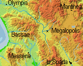
History: Before 370 B.C., the cities of Arcadia had been divided into a number of independent communities. Sparta had favored this arrangement and was able to keep the cities under its control by means of this division. After the Spartans were defeated in the Battle of Leuktra around 370 B.C., the Theban Epaminondas convinced (or in some cases "compelled") the townships to form a new capital on the northwest border of Laconia. It is clear that some of these cities wished to remain separate from the synoecism (notably Tegea, Orchomenus, and Heraea), but it is likely that the other cities were the driving force behind the formation of Megalopolis (i.e., the 'Great City'). Epaminondas only aided their cause and spurred them on by providing a Theban army to defend them during the construction of the city and its walls. Messene was also formed at this time and Mantinea and Argos were being supported by the Thebans in an effort to keep Sparta from gaining too much power. At the city's foundation, the walls were laid out with a five and a half mile circuit. This was such a broad area that the population would not long be able to defend itself properly.
Mantinea soon broke with the alliance and Megalopolis in 364 B.C. after
the league had tampered with the sacred treasuries at Olympia. In 362
B.C., half of the league fought against the Thebans, who prevented many of
the citizens of Megalopolis from returning to their former homes. In
353 B.C. the Spartans attacked the new city, but with Theban help they were
thrown back.
Soon after the Thebans' power declined, the Spartans attacked Megalopolis
again in 331 B.C., but with the help of the Macedonians, also an enemy of
Sparta, they were able to defeat the Lacedaimonians again. Its city
walls, which have been excavated at many places, kept the defenders safe.
Yet over time the population declined as colonists returned to their original
cities and jealousy between the townships kept Megalopolis from reaching
its true potential as head of the Arcadians. In 318 B.C. the
city was besieged by Polysperchon in his contest with Cassander, but they
were saved by an officer named Damis who repelled a group that had broken
through the walls.
For a while the city was ruled by tyrants. Aristodemus was the first and he was held in high regard. He successfully defended Megalopolis from a Spartan attack in which the Spartan king Acrotatus was killed. Later, Lydiades became tyrant only to voluntarily resign, at which time the city joined the Achaen League and was once again attacked by the Spartans in 234 B.C. This time the defenders benefited from a hurricane which blew down the Spartan siege equipment. Finally in 223 B.C. the city was sacked by the Spartan king Cleomenes III. Many escaped the city to Messenia and then returned two years later after another Spartan defeat, but the city had been laid to waste by the Spartans and many buildings were not rebuilt.
 At this time a great dispute arose over the size of the city walls. Some
wanted the walls to be rebuilt in their original courses while others wanted
a smaller circuit, easier to defend. The former party won and the walls
were rebuilt. They were enough to withstand a siege by the tyrant Nabis
but they soon fell into decay and we know that by 175 B.C. outsiders were
promising to build new walls. Strabo remarked that "the Great City
was a great desert," and Pausanias reflected upon the fallen state of many
great cities after seeing Megalopolis.
At this time a great dispute arose over the size of the city walls. Some
wanted the walls to be rebuilt in their original courses while others wanted
a smaller circuit, easier to defend. The former party won and the walls
were rebuilt. They were enough to withstand a siege by the tyrant Nabis
but they soon fell into decay and we know that by 175 B.C. outsiders were
promising to build new walls. Strabo remarked that "the Great City
was a great desert," and Pausanias reflected upon the fallen state of many
great cities after seeing Megalopolis.
Government: The Federal Constitution of the new Pan Arcadian union was democratic in nature; Megalopolis was just another city in the League in some respects. There was an Assembly whose official title was the Ten Thousand (Myrioi) that every citizen of the League was a member of. The Ten Thousand made war and peace, concluded alliances, and sat in judgment on offenders against the League. A Council (the Damiorgoi) was also formed from fifty members from the various cities. It had the usual executive and deliberative functions of Greek city councils.
Plan: The river Helisson divides the site of Megalopolis into two nearly equal sections. The city itself was on the south side with a marketplace and a Bouleterion where the Council of the Megalopolitan state met. On the north side of the river the federal buildings were built in the area known as the Oresteia. Here was the Thersilion (Federal Hall of Assembly) and the theater which served as an open-air hall for federal meetings. It is also thought that the dwellings of the permanent armed force, 5,000 men, were maintained by the Federation. This is also the area where the lodgings for the Ten Thousand were when they met in the city. Pausanias describes the history of Megalopolis here ( 8.27.1 ), and gives a better description of the buildings and site here ( 8.32.1 ).