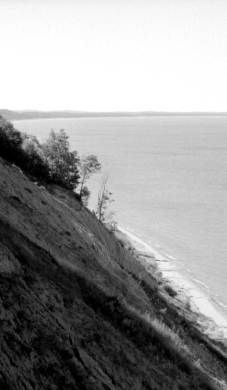
Highest Portion of Bluff
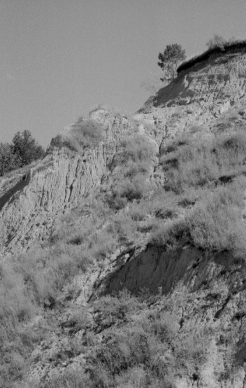
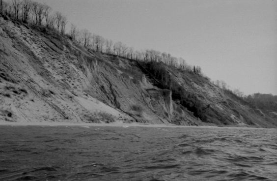
Small Formations Created by Uneven Erosion
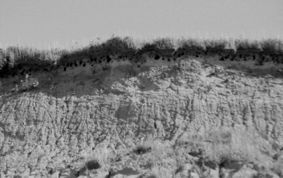
Swallow Nests
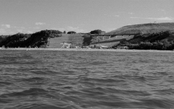
Generating/Pump Station with Reservoir Rising Behind Elevated Lake Shore Drive
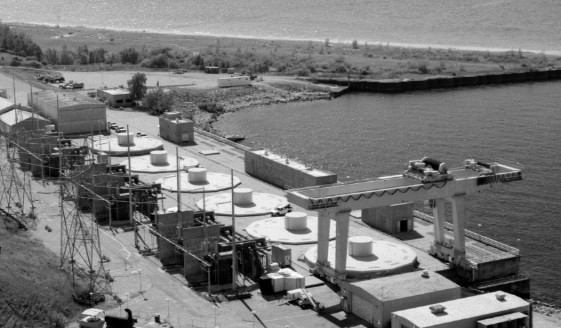
A Different Perspective on the Generating/Pump Station's Six Turbine Generators
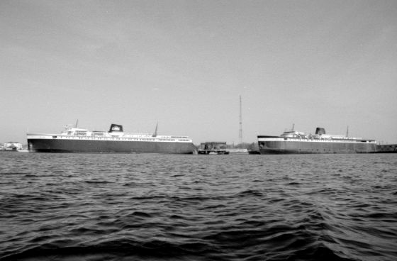
Car Ferries The Badger and The Spartan Docked on Pere Marquette Lake
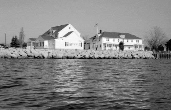
Ludington Coast Guard Station
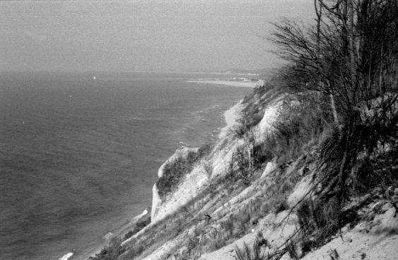
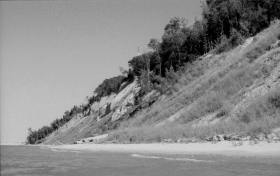
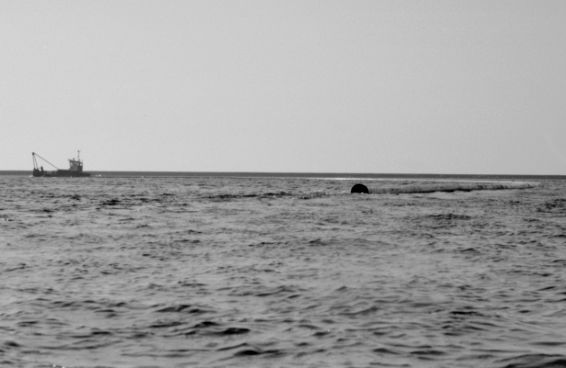
Cliff with Ludington Harbor in Distance
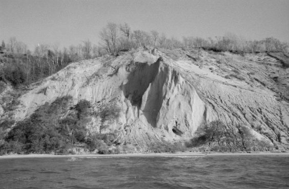
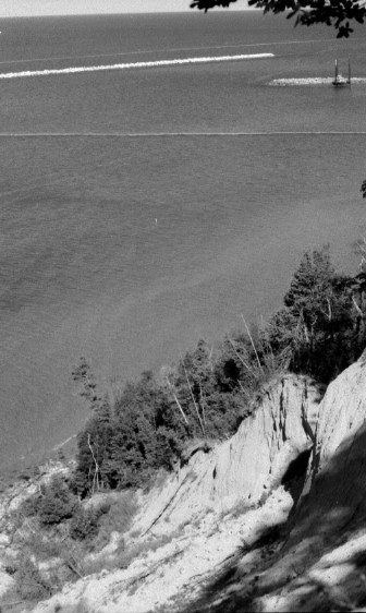
Cliff
Small Launch Towing Dredge Pipeline
Summer 2004 - Ludington Pump Station exudes a surreal mixture of natural remoteness juxtaposed with industrial-sized manipulation of the environment similar to the oft used effect in 007 movies where the climactic scene takes place at a large industrial facility on an isolated island paradise, stoic volcano, or zoned rural township. The first trip began on a midsummer weekend at Mears State Park in Mason County near downtown Pentwater and adjacent to the channel from Pentwater Lake. The beach is nearly empty. The unseasonably chilly water we have experienced acts against the warm sun in drawing people to the shore. The pump station, which is situated near the middle of the bowl formed by Little Point Sable and Big Sable Point, is 7 miles from the state park, which lies along the north side of Little Point Sable. The park is protected from prevailing southwest winds, but the waves gradually strengthen further north toward the pump station where the wind achieves a longer fetch. The water also deepens more quickly from the shore. Large schools of minnows frequently darken the shallower warmer water near the park.
A 240 foot clay bluff overlooking the lake adjacent to the pump station was an unexpected landmark. A sliver of sand below the bluff makes for a looming presence while paddling along. Unfortunately, this bluff does not extend to the horizon in both directions. It gradually rises from the shoreline over the course of a couple miles and only achieves impressive height over the last quarter mile near the pump station. Water and wind erosion have created small formations in the clay and sand face which is constantly changing. Residential development on top has accelerated water runoff erosion. A recent house-sized landslide lies in evidence at the bottom. If you stand at the bottom you can watch sand flowing down like lava thro' channels cut into the bluff and form cone shaped piles along the base. Erosion here does not take place on a glacial or tectonic time scale; it takes place in realtime. The bluff may not qualify as a cliff except when viewed from the other perspective. It is hard to maintain skepticism when you are on top looking down on SUBs (sport utility boats) 1 1/2 miles from shore. The sweeping vista of Little Point Sable is breathtaking on a hazeless day. The warning bouys and floating net which ring the pump station and seem to stretch endlessly outward from the perspective of the bobbing water are reduced to a postage stamp - well, at least a large envelope. On a second trip, a red Coast Guard patrol chopper charged north along the bluff 20 feet below me. On their return run they were almost at eye level as I glassed the inside of their cockpit and their clean-shaven faces.
At the risk of giving away the crown jewels, I will give an answer to the implied question of the last paragraph: How did I get to the top? Did I pull a Cliffhanger? The ultra-secret answer at the scene is both obvious and obscure. I will leave it simply as a riddle: Follow the water. I found the answer on my first trip. But be discrete and stay stealthy if you do not want to get burned by the dragon. The last time I was there the sounds of hammers and saws was going furiously just out of sight thro' the trees on top. Grievous bummer.
My subsequent day paddles to the pump station have been launched from a closer point. There is a hole-in-the-wall public park, named Summit Township Park three miles south of the pump station. It sits along the shore taking up roughly 200 feet of frontage at the point where the embankment finally drops down to the beach. The parking lot is ten feet above the water and there is a nice sandy set of steps down to the beach. The carry is 250 feet. Finding the township park is a difficult matter because it is nothing more than a hole in the trees along the road. The single lane asphalt driveway looks like every other private driveway along Lake Shore Drive. It is 250 feet north of the intersection of Deren Road where a small white sign hidden back in the trees next to the entrance announces the name of the park. I drove by it the first, second, and third times. No fees. No overnight parking. Do not be surprised during summer weekends to find a local family reunion or wedding reception consuming the entire tiny park.
Trip Report #2
November 5, 2006 - During the autumn, when every day goes by with a rumpled aluminum sky and the wind roars unhindered thro' leafless trees, it is rare to get a calm enough weekend day to paddle the lake and a bright sun to keep one warm between the cold air and chilly water. That day came.
The buoy wind and wave reports were trending down in the early morning to adequate levels, but levels which seasonally do not stay down for more than a few hours before rebounding upward. Infrared imagery of cloud cover revealed a large swooping arc of clouds from the north extending across the lake and intersecting Ludington. The latest image showed a tiny movement of the cloud edge north from the image an hour earlier. I left.
A boat launch on Pere Marquette Lake across from Ludington near the end of Lakeshore Drive provides easy access to the channel to Lake Michigan. Passed Buttersville Township Park there is a white cross atop a small knoll beside the road, a memorial marking the place french voyageur and jesuit Father Jacques Marquette is believed to have died in 1675. Asphalt drives lead around the memorial to a DNR boat launch, which may at first seem incongruous, but Marquette spent most of his short life traveling great distances by water. Not far from the boat launch, workers busied on several small floating barges covered with cranes, and one small launch dashed back and forth between the Dow Chemical brine plant across the lake and the flotilla of barges. The workers are pushing hard on a harbor dredging project before the ice sets in. It was Sunday.
Once passed the end of the outer piers the waves were 1 1/2 to 2 feet and not too steep with 7 knot winds out of the south. The line of high cloud cover was north of Ludington, maybe as far as Manistee. The sun was bright and felt warm against the dark wetsuit. The piers throw off a lot of reflected waves which turn the water around them into a washing machine of jumbled waves forcing me away into deeper, safer water as I turned south toward Buttersville Township Park. A large bulldozer absurdly plodded along the beach toward the pier. I recalled while driving pass Buttersville Township Park's beach, a yellow bulldozer sat in the parking lot next to a flatbed trailer piled high with sections of pipeline.
South of the township park, the bluff begins to climb to 220 feet at its highest point. DTE Energy and Consumers Energy jointly own undeveloped shoreline property along the high bluff a mile south of the park. A stunning and unique 70-foot high shear vertical cliff hovers just back from the water's edge along this parcel. The cliff juts from the embankment due to erosion of the softer surrounding bluff. Sadly, DTE and Consumers have recently put this parcel up for sale. Adjacent to the power companies' parcel is also 6/10ths of a mile of undeveloped public land owned by the DNR. A nice view from the top of the bluff can be found on this DNR land along Lakeshore Drive north of the pump/generation reservoir. A half mile north of Chauvez Road is a stubby radio tower on top of a hill. Directly across Lakeshore Drive from the radio tower is a dirt trail and a small white sign which simply reads, "No Vehicles." This is the access trail to the north end of the unmarked DNR land. Park along the road and walk the trail to the edge of the bluff for a view of Ludington's harbor, and if the haze allows, a view up to Big Sable Point and down to Little Point Sable. There are smaller clay formations along the bluff on the DNR parcel but nothing compares to the prominent drop just a little further north on the power company land which looks impressive even from the top of the bluff. Pity if it's developed.
The wind rose to 10 knots and the lake was making 2 1/2 to 3 foot waves. I decided not to paddle the additional mile to the pump/generation station. I was close to shore taking photographs of the bluff and made for deeper water where the waves are less steep. Waves from abreast tottered the yak. The rudder helped keep the kayak on a steadier track as I worked to avoid the few larger curling waves going out deeper to get around the pier. Quartering waves, going down waves at an angle, was too dicey for such cold water and strengthening waves. Once I got an angle to surf directly down the waves into the harbor balancing became even more precarious since the waves were coming unseen and unanticipated from behind. Paddle strokes were quick and short with more bracing. Once around the south pier I was relieved to get out of the waves and cold spray. In the harbor, the water darkened from the clear green of the open lake to the color of coffee stained by tannins leached from this autumn's fallen leaves.
A small launch was working in the outer harbor area and scooted into the channel. As I neared the Coast Guard station and the channel to Pere Marquette Lake the launch turned around and headed back out along the south channel wall while running along something floating in the water in order to push it away from the channel wall into the center of the channel. It was a thousand foot length of pipeline made up of connected sections running down the entire length of the channel. The pipe was a couple feet in diameter, capped at the ends, and apparently filled with air to float it. Once the pipeline was centered in the channel, the little launch grabbed a towline at the end, throttled up, and like a train engine towed the pipe out of the channel and into the outer harbor in a wide arc to the south. The pipeline will be used for hydraulic dredging of the outer harbor; a platform with a large pump will suck sand and water from the harbor bottom and send the slurry thro' the pipeline to a location on land.
Trip Report #3
October 14, 2007, 8:00am - The east wind blew cold, in the low 40s, at Buttersville Township Park. Thick fog produced by the warmer waters of Pere Marquette Lake flowed across the thin spit of land separating the two lakes and out onto Lake Michigan obscuring the pier to the north. The south was clear, but a long, grey curving front moved in end-wise from the west with some momentary drops of rain. The parking lot below the north end of the park's ridge is about 160 feet from the edge of Lake Michigan. The onshore wind, tho' brisk, kept the waves low. Although immersion is unlikely in the calm, 55 degree water, I wear a full-length wetsuit for safety reasons because I will be paddling over half a mile out around the pump reservoir station...to get to the other side.
The station is ringed by a two-mile long floating net which keeps fish from being sucked into the turbines. The net boxes in the lyre shaped side piers and a cap pier which directs the outflow to either side to protect passing ships from the current. Outer buoys warn boaters of the floating net, but they are too few and far between to be effective. There are only one or two along the entire half-mile north side. As a result the net frequently gets damaged by speeding motorboats. On a previous trip here I actually saw a cruiser fly pass the south side buoys and slam to a stop putting its bow over the net. I often wonder why novices buy a 20'-plus boat but are afraid of running it in properly deep water. Power station personnel are constantly mending the net and have become understandably quite protective of it. So it wasn't a surprise to see one of the station's small outboard boats along the south side net after paddling out and around, even on a Sunday, since the waves had been up for a few days probably preventing them from doing any maintenance. Workers could have been mending tears or preparing the net for oncoming winter. I didn't paddle up to talk because they were obviously busy and could have had divers in the water whose safety needs constant attention.
After passing the station workers I noticed some movement on shore below the high, steep bluff. Several deer walked along the shore adjacent to the power station. I stopped paddling several hundred feet away and fished out a monocular to watch the deer. Suddenly two bucks in front began sparring with each other as three does behind looked on. The bucks carefully lowered their heads, lock antlers, and tried to push each other backward like two furry sumo wrestlers. They battled on shore and I was surprised to see them also get into the lake and spar. One of the bucks ran along shore, spun around, and jumped wildly as if incensed or elated. A doe ran toward him and stomped the sand trying to scare him or stir him up to battle harder, but the battling was done. They all shortly disappeared.
I paddled up to the shore and took a floating break. While I gurgled down a thermos of hot cocoa to ward off chills, the power station, in an overprotective move, unleashed its dragon. Their fearsome-looking jack-up barge motored out of the harbor, over the net, and took up station two thousand feet out facing directly at me. There was no mistaking their intent. They don't like anyone paddling near their net, even outside of it. It's a good thing the waters are publicly owned because that gives me enough protection while outside the net. I finished the thermos and paddled out to see if the dragon wished to spar. Upon approaching they issued no challenge. As I passed between them and the net the pilot, in Stephen King fashion, spun the giant water spider of a barge in place and followed slowly behind turning over the diesel engine periodically as I nonchalantly puttered along the outermost mile-long stretch of the spider's web. The light wind had shifted southeast, but waves were less than one foot tempered a bit by the net's floats. No eagles or raptors were posted on the cap pier or anywhere in the vicinity showing the net is doing its job keeping large fish out of the turbines. There were also only a sparse number of cormorants on the rocks compared to two years ago when I visited although that may be due to seasonal variability. Another power station worker and outboard boat was busy working on the north end of the outer net as I returned.
I have now paddled all the shoreline between Pentwater and Grand Traverse Point, except for a twelve-mile stretch yet to do before the ice sets in.