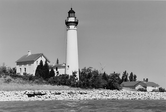
South Manitou Island Lighthouse
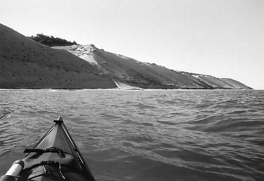
Western Bluff
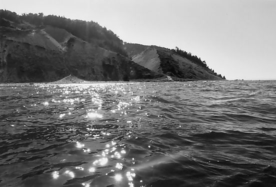
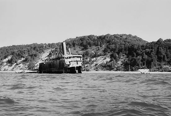
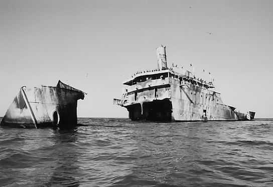
Wreck of the Francisco Morazan
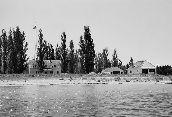
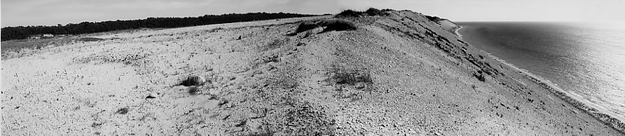
Former Life Saving Station with Boathouse (Right)
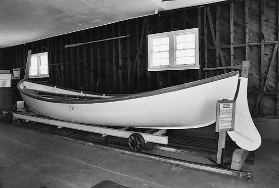
Rescue Launch
August 6, 2005, Saturday - I arrived at the Sleeping Bear Dunes National Lakeshore Philip A. Hart Visitor Center in Empire at 9:00 am to pick up an annual access permit for the car and a two night camping permit. The visitor center is 300 yards east of the only traffic signal. Since the trip to South Manitou Island will be done by kayak rather than by taking the water taxi from Leland, a float plan must be filed with a description of the kayak and emergency contact information. "It's for my safety," the ranger says with a look which belies the truth: It's for the Coast Guard's body recovery effort. My departure point was Good Harbor Bay Beach, but the ranger suggested starting from the cannery in Glen Haven because it is a shorter distance, 8 miles to the island dock facility at Sandy Point instead of 11.5 miles as my plan. My main consideration was wind and course direction, not crossing distance. The north-south course from Glen Haven to South Manitou would put me directly against a forecasted headwind for Monday's return crossing. In order to make it to work on time Monday, the quickest route for that day and not necessarily what might be faster on the trip out Saturday was the determining factor. I stuck to my plan and pushed off the beach at Good Harbor Bay Beach at the end of Brohman Road at 10:00 am (also known as Coleman Road and County Road 669).
Good Harbor Bay was true to its name with flat calm water. That changed dramatically at Pyramid Point and the beginning of the 8 mile open water crossing. Once facing the open lake, the wind and waves exceeded the generous nearshore forecast put out by NOAA the night before upon which I based my go decision: "1005 PM EDT Fri Aug 5 2005 - Saturday... southwest wind 5 to 10 knots becoming west early in the afternoon. Mostly sunny. Waves 1 foot or less." The wind was out of the southwest at 15 knots pushing 1 1/2 to 2 foot waves from the front port quarter. NOAA's offshore forecast provided a slightly more accurate description of wind and wave conditions for the nearshore area. Within 3 miles of Pyramid Point the waves were chaotic. Only at the point where open lake waves could reach around Sleeping Bear Point from the south did the waves begin to take on some regularity, but they also became larger, 2 to 3 footers. I quickly acclimatized to the wave action, but wondered if the progress impulse could lead me into greater danger. Within 2 miles of Pyramid Point I already had to fight thro' the four foot wake of a cabin cruiser which passed 100 yards off the bow at the same time another one passed 300 yards further heading in the opposite direction. After the midpoint of the crossing, a line between the westernmost edge of Sleeping Bear Point and the easternmost edge of North Manitou Island, the waves took on more cream and my sunglasses were constantly covered with spray from then on. Never having visited the island before, I set bearing toward the middle of the island from Pyramid Point by maintaining a heading toward the visible white lighthouse slightly to the south. As it turned out, the dock facility was closer to the lighthouse than my initial bearing. The sheltered water of the dock facility's bay was a welcome reprieve for my aching arms. Blisters later bubbled up on two fingers; half-fingered gloves were the wrong choice. It took 3 hours to make the 8 mile crossing; 3 1/2 hours from the point of departure in Good Harbor Bay. I hoped my slowness would translate into a brisker return Monday.
Several cruisers and a sailboat lay at anchor around the quiet arc of the half-moon shaped bay. A large boat which looked to be the regular water taxi was tie up at the dock. I landed 100 yards east of the dock and cut across the ranger station's lawn passed the maritime flagpole and did not see the sign just up from the dock indicating camper registration was available in the boathouse directly up from the dock. I should have inquired about the registration process at the visitor center in Empire. As I strolled toward the visitor center on South Manitou Island a ranger rolled by in an electric cart, but I didn't bother flagging him down. I expected someone would be on hand at the visitor center to answer questions. It was unmanned. I picked up a brochure about the island which included a map with campground locations. I was tired and headed off to a campground mistakenly discarding the registration process meant to reserve individual campsites. Reserving a campsite in advance was problematic because I was using a hammock instead of a tent. Most campsites do not accommodate a hammock. Pre-inspection of the trees is necessary. If the campsite is on the other side of the island, like Popple Campground, pre-inspection becomes infeasible. I pushed off shore. Weather Station Campground was a mile around Sandy Point into the wind. My arms said no. Bay Campground was just up the shore a half mile, but I had a distaste for the sight of the cabin cruisers lying offshore after my run in with one during the crossing. I went north across the bay following the wind to Popple Campground 3.5 miles around the leeward side of the island where the water was calm. The campground is obscurely marked along the shore by a five foot high 3x3 white wooden post with the top six inches painted light blue set back near the tree line in back of the beach where a small, easily missed footpath climbs the bank into the trees. There are a small number of campsites, less than ten, about half of which were empty. I strolled around inspecting the trees for hammock-ability and squatted on campsite No. 6. Camping permits are attached to the site's trail marker. (Apologies to whomever, if anyone, if I infringed upon their reservation rights to the site. No one stopped in my camp to inquire about my presence. I would have easily prepared to nap an hour after darkness on the beach next to my yak if they had.) After a hike further along the shore and up onto the north end of the western plateau, I ate at camp and refilled the water bottle and hydration bag with a water filter pump while sitting in the lake on a rock. The weather radio received a good signal, and tomorrow's weather would be much like today's sun and breeze.
August 7, 2005, Sunday - Six O'clock rise to fix breakfast and prepare to depart camp. With no alarm clock I try to regulate time by hitting the hammock early. This will be more important Monday because I want to cross back earlier during the day to catch a quieter broadside wind. Today's plan is circumnavigation of the island, about 6.5 more miles; this is another good reason to get an early start since much of this segment is exposed to the open wind and waves along the western and southern sides of the island. Fixing oatmeal and packing ate up too much of the morning. The 300 foot high bluff along the island's west side towers above the water, its shadow lying along the shore indicating my lateness. Shallow shoals were marked by rolling waves and avoided. A large flock of cormorants lifted off the water just beyond the breakers on a long shoal. The birds also stood around in review along the above water superstructure of the wreck of the Francisco Morazan. I put ashore, ate a snack and broke out the snorkel gear for a swim around the wreck. Two foot waves kicked up light silt into the water making it a little more difficult to see the haunting hull and sunken structures. Big black cormorants sitting in dead trees atop the bluff overlooking the wreck lent a foreboding aire while visiting the ill-fated ship.
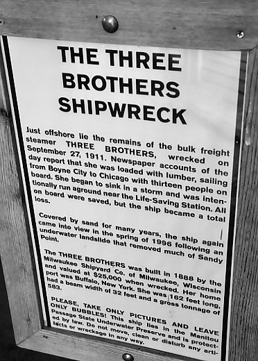
A thick haze shrouded the mainland making it difficult to discern the location of landmarks like Sleeping Bear Bluff, Sleeping Bear Point, and Pyramid Point which usually stand out because of the contrast of their light sand against the dark forest. I made a note to take a compass bearing off my area map when I return to the dock facility to double check where Pyramid Point lies on the lumpy horizon. Upon rounding Sandy Point and just within sight of the dock I met two splashing snorkelers and asked if they had found a shipwreck; they said they had. I noted the shoreline location to check it out later. I finished the circumnavigation in the early afternoon back at the dock and set about making another attempt to figure out the campsite reservation system to set up at Bay Campground for the night. The visitor's center is still unmanned but holds a few historical artifacts from the former island community displaced by the park service. Sleeping Bear Dunes, Isle Royale is also an example, were formed thro' unsettling land taking practices by state and federal authorities now long since forgotten since the uprooting of the former residents during the great environmental movement of the 1960s and early 1970s. I wandered into the boathouse out of curiosity after filling a water bottle and hydration bag from a nearby drinking fountain and noticed a camper registration desk, also unmanned. Atop the desk was a list of the campgrounds and numbered campsites at each campground with X's drawn through a few of the campsite numbers. I guessed this was the extent of the reservation system and set off to Bay Campground to inspect sites and return to cross my desired site off the list before the water taxi returned at 4:00 pm, in the unlikely event it disgorges a load of backpackers looking for campsites. I looked over many campsites and finally selected campsite No. 19 located on the beachside of the campground with its strong red pines for the hammock, paddled back, and crossed it off the list. Inspecting the reading material inside the boathouse a small map caught my notice on the east wall marked with the locations and names of several area shipwrecks. The only ranger around was a young woman operating a foot pump on the park service's zodiak trying to keep its pruned air chambers from joining the island's other shipwrecks. The park rangers focus their welcoming service toward the group of backpackers who come in on the water taxi at a specific time and tend to other duties throughout the rest of the day. Kayakers, who straggle in at odd times, should expect to rely more on self-help or visit the ranger station to find assistance. I returned to the area where the snorkelers had indicated a shipwreck, but they were now gone. A search of the water soon revealed the dim outline of the wreck of the Three Brothers freighter along the edge of the drop off 100 feet offshore out from a small white utility shed. I put ashore, fixed a dive flag to the kayak, and towed it out to the wreck. A topless hull is the only visible sign of the wreck. I dove and traced the hull part way as it disappears down the dropoff. The hull is filled with sand and gravel leaving no sign of tackle or artifacts. As I returned to the dock the water taxi arrived from Leland and forty or so backpackers carried their gear down the dock and stood in queue for the ship's captain for the second and last trip of the day off the island. No one disembarked from the empty ship once she tied up. Before dinner I strolled up the beach around the bay near the point to the northeast where access to the tip is posted forbidden in order to conserve a seagull rookery. It is safe to pass the area this late in the year without disturbing any nesting birds. The temperature dipped slowly after sunset and by midnight I had to get up and breakout the sleeping bag. Stars sprinkled the night sky; stars I haven't seen since last Labor Day.
August 8, 2005, Monday - Six O'clock on the dot, the eastern horizon is beginning to stoke the day. A simple breakfast of granola bars and water brings on the task of packing and departure. I paddled to the dock facility and filled my water bottle and half filled the hydration bag. At 7:30 am I departed the dock and began crossing toward the hazy lump of Pyramid Point with south wind less than 5 knots and one foot waves at my beam. I endeavoured to make good time before the rising sun cranked up its wind machine. By 8:00 the wind freshed to 5 knots. I was pleased to reach the midpoint of the crossing at 8:30, a half hour faster than my push Saturday. Chop coming up from Sleeping Bear Point began wetting my surfaces. Sailboats and other craft moved from the north down the passage between the crib lighthouse and Pyramid Point. A tug and barge suddenly appeared out of the gleam a mile off my front port quarter. I realized a supertanker could have come at me thro' the water reflected sun and plowed me under before I knew what was happening, which meant anyone crazy enough to motor into the gleam off my rear starboard quarter would not see me until they felt the thud, if they even notice the impact. I began making regular backward scans for traffic and noticed a large white form thro' the haze entering the passage. If it was a laker, I had a half hour to get out of the shipping lane, The ship gradually turned out to be a beautiful three masted schooner under full sail. As they entered the passage they dropped sails and raised a spinaker allowing the wind to pull them up to North Manitou Island far behind me. The wind was edging toward 10 knots and the waves were 2 foot across the shipping lane. I reached Pyramid Point at 9:30 knocking an hour off my previous crossing time. I landed to strip off the wetsuit now that the cool open wind was behind and another bright cloudless day on calm Good Harbor Bay lay ahead. Once on shore the civilization of flies, absent on South Manitou Island, offered their traditional welcome. A little passed 10:00 am I arrived back at the car at Good Harbor Bay Beach. After a swim to clean up, I loaded the car and motored away at 11:00 with just enough time to wash up and make it to work.