On the Water in Empire
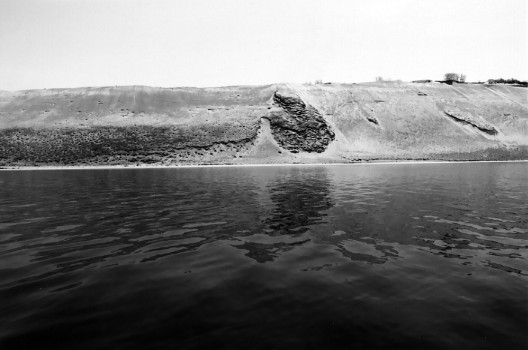
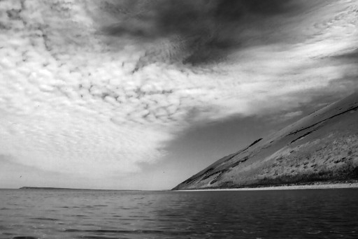
Sleeping Bear Bluff
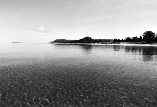
Sleeping Bear Dune from the Water
Old Dock Pilings in Front of the Boat Museum Housed Inside the Glen Haven Canning Co. Building
Maritime Museum Inside the Former Life Saving Station
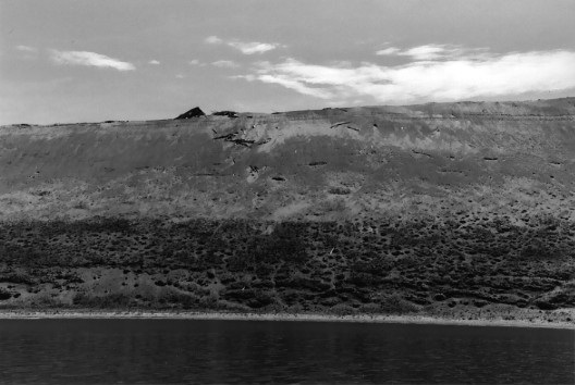
Sleeping Bear Point
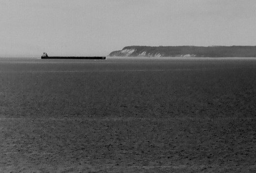
Laker Making the Manitou Passage Along South Manitou Island
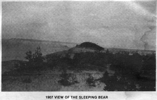
Historical Photo of Sleeping Bear Dune from Park Service Brochure
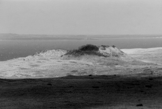
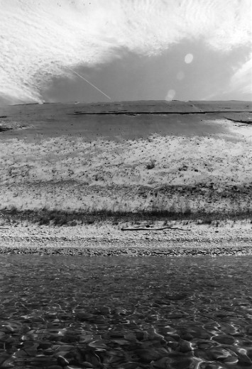
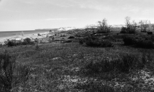
Remnants of the Sleeping Bear Dune (Photo: December 31, 2004)
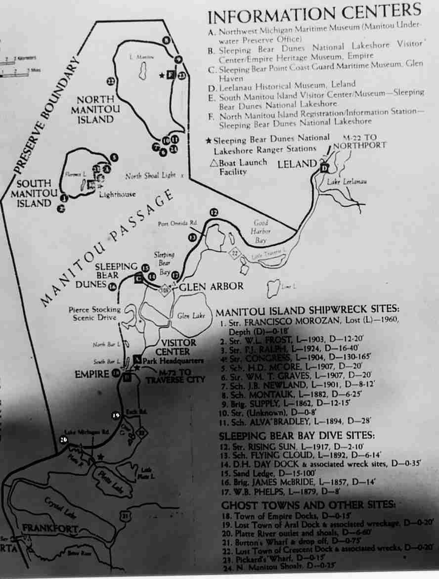
Manitou Underwater Preserve Committee's Inaccurate Brochure
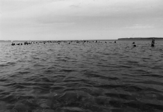
May 21, 2005 - 10:00 AM start from the village of Empire's municipal park. Turn west at the blinking yellow light on M22 and follow the street to the end. Turn right, go a block then turn left to find the lakeshore park. The lake is flat, and the sunny sky means light offshore winds will pick up later but will not present a problem. Once passed the cottages an occasional merganser can be found resting on the stones near the water's edge. Unlike the many goldeneyes flying by, mergansers allow closer approaches.
Michigan may lose some species like robins during the winter, but it also picks up a few from the far north. During the winter Sleeping Bear plays host to species otherwise found at the arctic circle during breeding season, including snow buntings. Sleeping Bear's frosty barren plateau and isolated grassy lowlands bear a remarkable resemblance to tundra habitat.The late morning sun hits the bluff yet provides some shadows for contrast. The namesake of the park, a perched dune of sand and brush atop the 400 foot high plateau, is impossible to see from the water. The only sign of its presence are several ancient tree trunks, which were once buried deep inside the dune, spilling over the top of the bluff. Since the 1950s the Sleeping Bear Dune has been gradually blasted away by the wind. Once it stood 234 feet above the plateau. Now it is a carved out shell less than 100 feet high whose greater substance is scattered across the plain. In forty more years there will be no sign of it at all.
Glen Arbor is 11 miles of shoreline to the north. The offshore wind pushes and accelerates around Sleeping Bear Point and was carrying 10-15 knots at Glen Arbor across the open bay. The point provided cover on the paddle back and shadowed the wind down to 5-10 knots. I put the sprayskirt on expecting wet conditions rounding the point. While the wind and waves picked up around the point, surprisingly, they dropped off considerably once back near the escarpment despite being out in the open. Wavelets focused sunlight on the sandy bottom producing slowly shifting sinuous tendrils of light making the bottom appear as living marble. The waves never reached one foot on this mild day even around the point. The occasional round wake from a passing laker, sometimes seen, sometimes not, raises crashing along the previously silent shore.
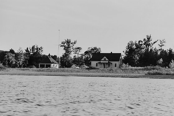
The long skeletal outline of the General Taylor, a propeller-driven wooden ship, lies in 14 to 16 feet of water 190 yards offshore where the north end of Sleeping Bear bluff tapers down to the shore. The General Taylor was sent down in an October storm in 1862 (ref.) after many mishaps (ref.) over its brief years. The calmness allowed good viewing of the wreck thro' the clear green water. It is also an easy snorkel tho' I didn't have the gear for this trip. Its bow rises to within 7 feet of the surface, while stern, topside and much of its sides lay somewhere other. Ships were dropping at the rate of once a week into the Great Lakes back in its day as maritime commerce played high stakes with the unpredictable weather in order to supply logging and mining camps and move lumber and ore to newly industrializing cities in the midwest and war fighting cities in the east during the great conflagration. The park service operates a maritime museum at the site of the former Coast Guard station in Glen Haven. The station has a white yardarm-style flagpole along the shore and is a half mile west of the Glen Haven Canning Company building which also houses a boat museum for the park service. Both are nice stops to pick up regional history.
As I near the observation platform atop the south end of the high bluff, I notice a few trekkers climbing a nearby path stretching straight down the face of the steep bluff. None are coming down; it must be approaching supper time. Each person exerts 15 or 20 steps and stops to rest. Some stand, some lie back against the rise. A last young couple embraces at the bottom before beginning the daunting climb. I put ashore for a quick swim and walk along looking at stones. Fifteen minutes later as I paddle away, the young couple have the better part of the 450 foot embankment yet ahead. I return to Empire at 6:00 PM.
Trip Report #2
June 2005 - A mid-morning start in Good Harbor Bay at the end of county road 669 a half mile west of Little Traverse Lake. Calm lake with puffy cloud cover moving up from the south. I paddled west around Pyramid Point to Glen Arbor, about ten miles. Swam around the remains of the 1917 wreck of the wooden, propeller-driven ship Rising Sun (photo) along the point. A boiler breaks above water and some iron frames lay on the bottom about 120 feet from shore. The wind gradually built along the west side of the point thro' convection and put up 12 to 16 inch capless waves which were easy to manage and aided the return. A large wooden structure lies sunken north of Glen Arbor. Might be the remains of the three-masted schooner W.B. Phelps or it could be a dock.
Trip Report #3
July 23, 2005 - Snorkeling on the wreck of the General Taylor. 10 am start from the beach halfway between the boat museum and the maritime museum in Glen Haven. The lake is calm and sunny. After rounding Sleeping Bear Point I located the wreck and put ashore to break out the fins and snorkel. I towed the kayak out to the wreck and anchored her with a downrigger cannonball tied to parachute cord. There are a few hooks and rings on the wreck, probably used to fasten down transported lumber to the deck. Other artifacts include a steel capstan with square holes for four wooden handles to manually winch loads around the deck, eye bolts, pins, cables and a pulley housing. What few remains will hopefully educate and entertain future snorkelers and kayakers. The maritime museum houses artifacts saved from other area shipwrecks, such as, compasses, steam whistles, and tackle. The hull timbers of the General Taylor suffer a few zebra mussels and algae growth but should remain for many decades to come.
Trip Report #4
September 17, 2005 - There is some confusion about the identity of the General Taylor wreck caused by the Manitou Passage State Underwater Preserve brochure I saw and photographed on the wall of the boathouse on South Manitou Island and a well known Great Lakes diving book. Both indicate the wreck located where Sleeping Bear Bluff tapers down to the water is the wreck of the James McBride, a two-masted wooden brig which sank in 1857 carrying a load of lumber, not the wreck of the General Taylor. Records indicate the James McBride is 125 feet long. The wreck in this location appears to be longer. The General Taylor was 173 feet long. I am revisiting the wreck with some string knotted at 10 foot intervals to measure her length and settle the issue.
It was an early afternoon launch from the boat museum in Glen Haven with sunny skies, light westerly winds and half foot waves. On the way around Sleeping Bear Point I tried to locate a possible wreck I noticed on an earlier trip. It was in deeper water and nothing was discernable at the time except a dark enlongated shape below due to waves. It could merely have been an area of algea-covered rocks which frequently occur in this area. Finding and refinding deeper wrecks is a happenstance process with poor landmark references. GPS would not make the process any better. I know of three different sources of GPS readings for the wreck I think is the General Taylor, including from a well known Great Lakes diving book, and none of them match up. In fact, none of them describe the location of the wreck accurately enough to even be useful in finding it. GPS can sometime hinder a trip rather than help. I only took a vicinity landmark reference on first sighting the possible wreck. Luckily I happened near it again. With smaller waves I could now easily make out the bow, ribs, and keel of a shipwreck lying more or less parallel to the shore. I paced off its length with the kayak and estimated it is about 100 feet long. I suspect this is the wreck of the James McBride and the brochure and book I read incorrectly identify the wreck of the General Taylor as the James McBride. I took two points of reference. There are two large dunes west of Glen Haven at the tip of Sleeping Bear Point near the sand ledge which runs out into the lake. The first reference point is the west side of the west dune where a large sweep of barren sand begins. The second point is the westernmost point of North Manitou Island. Follow that line out, cross a dark patch of algea-covered rocks, and the wreck is just beyond in 18 to 20 feet of water. The bow lies on that line with the wreck stretching east-southeast. I put ashore, broke out the snorkel gear, and fixed a large diving flag to the kayak, which I use as a base station while snorkeling; an empty kayak floating on the water can draw unwanted attention without a diving flag. I swam back out 280 yards towing the nose of the kayak. (I checked the distance on Terraserver and Google Maps where the speck of the wreck is visible on their aerial and satellite photos.) I dove down. The pressure tightened around my chest and pressed the snorkel mask tighter into my face until I added air thro' my nose. My hand ran down the keel carefully so as not to get cut by sharp zebra mussels clumped here and there in the algae. A couple smallmouth bass make their home here and several finger-long guppies scoot along the keel. The depth allows only a short moment on the bottom before bursting to the surface for a breath. The bottom half of a snapped off sailing mast lies across the side pointing toward South Manitou Island. The pointy bow differs from the more rounded shape of the other wreck which I next visited.
The wind rose a bit and the waves were now up to 1 foot along the western side of Sleeping Bear Point. Once the wreck was located, I towed the kayak out trailing the string and anchored it nearby. I looped the string around the upswept bow of the submerged wreck and cinched the loop tight. I counted the knots while slowly swimming to the stern, pulled the string as taut as possible, then counted the knots again making my way back to the bow. I measured the wreck at about 140 feet long, which definitely rules out it being the 125-foot James McBride. Since the stern is missing the ship could have been longer which rules in the General Taylor. Lesson: Don't place too much stock in diving book and brochure descriptions of shipwrecks and their locations. Be prepared to spend time patiently searching a general area.
Trip Report #5
November 24, 2006 - Summer unofficially ended this day with the temperature reaching 59F in nearby Traverse City. I was a bit late getting started because the roads thro' Traverse City were clogged with shoppers this Black Friday. The sky over Good Harbor Bay Beach was blue and sunny. Calm water protected from but rippled by the south wind stretched invitingly along the bay. The goal was to paddle to Leland nine miles to the northeast. A storm had removed 6-8" of sand from the beach since my last visit exposing a carpet of large stones to gingerly cross while carrying the kayak to the water. Although the water was calm, the crosswind presented a weathercocking problem. I grew tired of leaning the kayak to correct the weathercocking and lazily dropped the rudder. As the bayshore curved from eastward to northward the tailwind and sapling waves sped progress toward Leland. Rounding Carp River Point for the approach to Leland, a Coast Guard patrol chopper cruised north overhead. There are not many lake users about this time of year, but the cold water and sudden changes in wind make this a particularly dangerous time for those who stray from shore. Low swells from Pyramid Point mixed across the wind-driven 1-footers from the south. Beyond the point. the wind waves were blocked and only the easy swells remained. I reached Leland harbor in just two hours; it was 4pm. The return paddle would be accomplished partially in the dark, a new experience.
Next to the marina a local fellow fished from a small metal rowboat for late fall salmon and steelhead with an anchor rope off the bow and a long fishing pole out the back behind the docked Manitou Island ferry. Passed the marina, a torrent of water fell over the 8-foot high dam holding back Lake Leelanau. Below the dam, the outlet runs just a hundred yards as old wooden shops, restaurants, boardwalks and boats snugly press in around the water. I drifted back down from the dam and pulled the kayak out at the marina boat ramp. A grocery store to replenish for the return paddle is up a block from the marina. In the meat dept. in back of the store sat two soup hot pots. One with potato soup or chowder and the other with super chunky beef stew. The stew smelled wonderful ladling it into a bowl. An old fashion glass bottle of Shetler Family Dairy skim milk was a fine compliment. The slogan printed on the Kalkaska dairy's milk bottle explaining their lack of use of antibiotics and hormones offered an example of north Michigan's wry wit: "Our cows aren't on drugs - But they are on grass!" Leland held its annual PJ Party for holiday shoppers earlier today. All shoppers wear pajamas from 8-10am on the Friday after Thanksgiving and get special discounts and sales. It was now late afternoon. The rushing crowd of bunny-slippered shoppers had receded. Back at the boat ramp, I sat on the marina wall and ate as the fisherman rowed in, pulled his rowboat noisily up the ramp a few feet, and rolled it upside-down to the side. A local couple walked up the dock to the parking lot, jumped into their car, and proceeded to drive down the boat ramp and into the harbor. Lucky for them they were driving/piloting a rare, little red Amphicar, an amphibious car imported from Germany in the 1960s. They kicked in the propellers without a pause, cruised passed the docks, and disappeared around the pier toward the open lake. A few minutes later they returned and drove back up the boat ramp.
The return paddle was not quite as bad as feared into the south headwind. The gusting wind was failing and this kept me dry once around the point rather than wet and cold. The dropping sun painted a beautiful sky with wispy strokes of vibrant pinks and moody purples as the sun settled behind a bank of dark gray clouds but somehow found an opening below the horizon to cast a wonderous light for a few minutes. A sliver of the moon offered only light to shimmer on the water and nothing useful more as darkness deepened. I tried to stay far enough from shore to avoid the protruding dock ruins off Good Harbor Beach which is 3 miles east of and not to be confused with Good Harbor Bay Beach. It was very dark as I began the last section of the paddle along the low jack pines which line the belly of the bay. The black stumps of the dock ruins could just be discerned in the distance allowing travel closer to the shore possible. Good Harbor Bay Beach has no lights to spot it by. It has two landmark features if a paddler is without a headlamp: County Road 669 which ends at the beach interrupts the continuously passing silhouette of the jack pines along shore. Otherwise, if one has a headlamp, the road signs at the end of the road will reflect back. A last distinquishing fact about finding Good Harbor Bay Beach in the dark is that the end of County Road 669, the soft point of land on the west of Good Harbor Bay, and the North Manitou Island Shoal Lighthouse very closely line up. The lighthouse has a periodic red flickering light which can be seen everywhere along the bay except to the west of County Road 669 where the point obscures the lighthouse. If I stopped seeing the regular flash of the lighthouse, I would know I had paddled too far around the bay and passed Good Harbor Bay Beach in the dark.