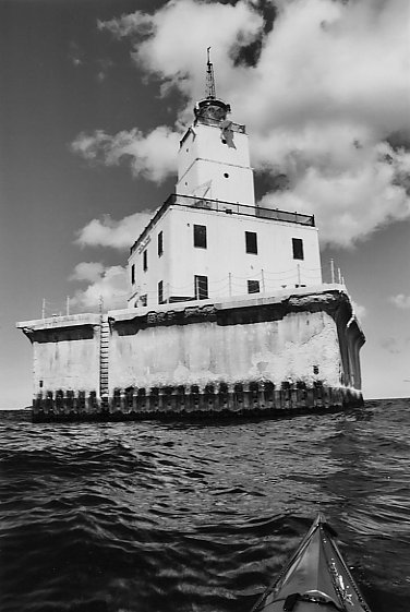
North Manitou Shoal Lighthouse
View Of The Crossing. Lighthouse and Pyramid Point In Background
Village of North Manitou. Dock At Right; Ranger Station At Left
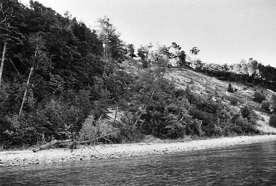
North Side Of Island
West Side
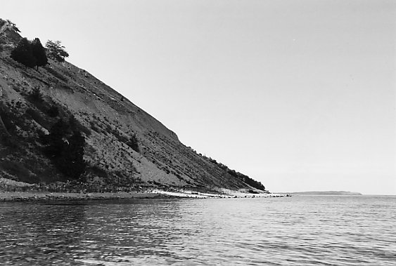
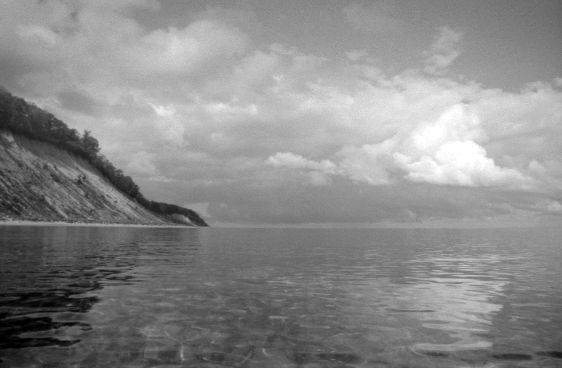
South Manitou Island In Background
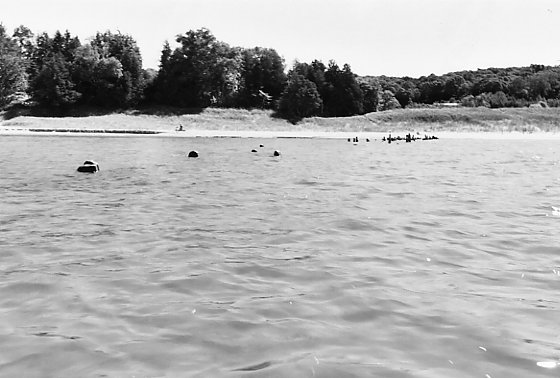
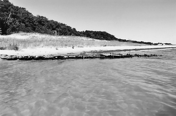
Ruins Of Crescent Dock
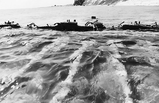
Shipwreck East Of Donner's Point
More Wreckage
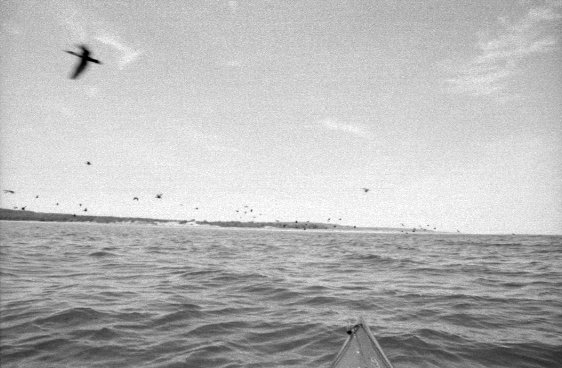
Resident Flying Circus
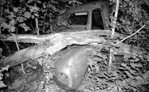
Old Truck at Stormer Camp
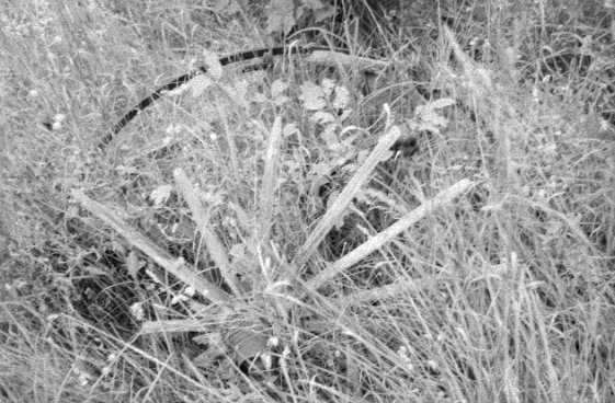
Wooden Wagon
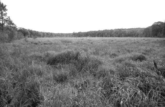
Wetland
Sunday Morning
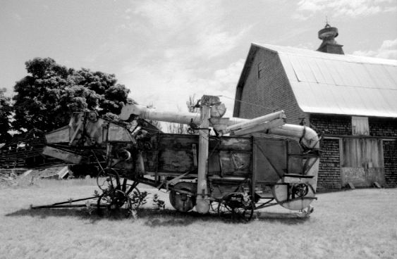
Grain Thresher
Brown Trout
Arthur M. Anderson passing the Whaleback
September 3-4, 2005, Saturday - The nearshore forecast indicated the north wind would drop off in the early afternoon and 3 to 5 foot waves subside to 1 to 3 foot. M-37 was strangely empty during the morning drive up to Mesick. Not a single motor home nor fifth wheel trailer was on the road. Gas station signs listing $3.20 per gallon gasoline may have kept them home this holiday. I arrived at the visitor center in Empire at 10:30 am to pick up a camping permit for North Manitou Island after taking my time driving in order to allow the wind to play out. The ranger behind the counter skeptically noted some guys stopped in Friday and bought permits only to return for a refund after looking at the waves. I had just come from the beach in Empire and seen the lake, I explained. The ranger's only instruction was to try to let someone at the island dock facility know of my arrival.
The paddling started at 11:30 with an armpit wetting whoosh into the surf at Good Harbor Bay Beach. The lake always looks worse at its edges, but once out passed the sandbars things settle down. The wind was piling up waves in the bay out of the north presenting a head-on battle all the way out to the island until close enough for the island to shadow the wind and waves. The water off Pyramid Point was a sloppy washtub of reflected waves or clapotis. The point seems to take its name as much from the shape of the waves around it as from the shape of the point. At times the kayak shot off sharp waves like a skateboard off a ramp and slapped down on the backside. It was disconcerting when occasionally a wave and the kayak bow rose above the horizon, but the nearshore forecast bore out accurately. The going was messy until roughly the navigation lane passed the green buoy marking Pyramid Point Shoal off the starboard. Bearing was set on the North Manitou Shoal Lighthouse marking the other side of the navigation lane and North Manitou Island beyond the lighthouse. Nearing the lighthouse, cormorants poured down off its railings and ridges toward the water as if someone had dumped a giant pail of black ink over the lighthouse; the horizon wavered with the flapping of hundreds of wings. The protected south side of the crib style lighthouse was the only place to pull the camera out. The lighthouse issues melancholic fog horn bursts. From the lighthouse I headed to the west side of Dimmick's Point. The calm water on the sheltered southern end of North Manitou Island was a good place for a break after tussling with 6 1/2 miles of open water for 2 hours and 45 minutes. Dimmick's Point is off limits until mid-August for landing due to Piping Plover habitat. I traveled along the shore up the east side of the island and reached the dock facility at the village of North Manitou around 4:30 pm. Camper registration signs lead to a squat brick building with a cash register sitting on a table in an otherwise barren room but the door was closed and locked. A nearby fountain was convenient for refilling water bottles. There is no ranger station, per se, but the ranger who handles camping registration lives in a plain white house up the path from the dock, turn left, and his house is the largest one at the end of the path. North Manitou Island is divided into zones for dispersed backcountry camping, and the registration process records which zones campers plan to visit. The island also has a single campground with reservable campsites near the dock facility. I paddled off to the north side of the island to find a campsite for the night. I followed the shore until coming to a spot in the vicinity of the Maleski Place or the Fish Shack where a bluff suddenly rises from the shore. I beached and searched the shore east of the bluff for a campsite and noticed a small path with footsteps in the sand leading thro' the tree line. Just inside was a large brushed out campsite. The path led further thro' the forest along the base of a steep 40-foot high tree-covered ridge to a second campsite and finally ended at a larger footpath running up the ridge. The shore faced South Fox Island visible on the horizon. After emptying the kayak and setting up camp, I put the kayak out of sight just inside the tree line. Boiled water softened up a combination of instant rice, chicken soup broth and deviled ham to go along with hot cocoa and a brick heavy package of multigrain bread. The park service website warns campers about chipmunks saying they are like little wolves on the prowl for food scraps. No sooner then I began eating, a brazen little munk scurried into camp and began poking thro' my equipment and probing closer to the bread brick. By carefully preventing the dropping of any food scraps, the chipmunk soon went away without returning. Full-fingered gloves did a better job of preventing blisters after the paddle, but I would learn tomorrow even these have their limits. I tried unsuccessfully to raise the weather forecast on a tiny Sony model SRF-M37V earbud type radio with 7-channel weather band doing a full circle directional sweep on each channel with radio in outstretched hand to achieve the best antenna effect from the earbud wires. The Sony model SRF-M85V is similar in construction and probably would have the same poor results. I pulled out a larger, heavier Springfield 7-channel weather radio with a short whip antenna and received good reception after directional adjustment. The nearshore forecast was good for Sunday but downgraded beginning Sunday night into Monday and Tuesday with 10 to 20 knot south winds and 2 to 4 foot waves. Option #1 - paddle back to the ranger station and find out if there is room on the ferry from Leland to haul my kayak back Monday and paddle from Leland to Good Harbor Bay Beach. Option #2 - stay the full tour thro' Tuesday, which I took as a vacation day from work, and circumnavigate the island and camp south of the ranger station partially protected from the south wind and bang back thro' four footers to Pyramid Point on Tuesday. Option #3 - Bail out Sunday while the getting is good. Distance paddled today: 15 3/4 miles.
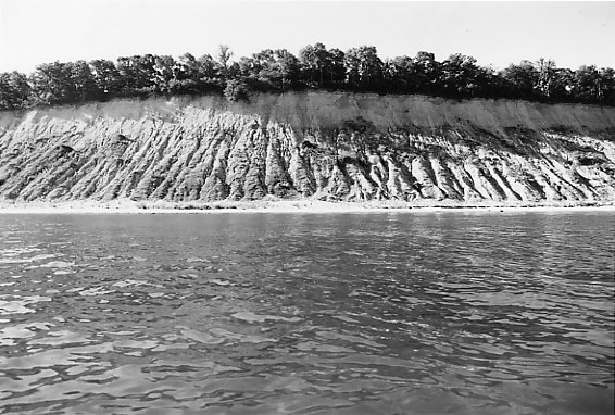
Sunday - The rising sun poked me in the eye over the edge of the hammock at 8:00 am. Over two packets of oatmeal I decided to finish circumnavigating the island then return to the ranger station to check into the ferry capacity question. The wind was light out of the north east with slight waves as I entered the water at 9:30 am. The following wind helped push me along. Around the point the wind shifted 180 degrees to a light headwind as I paddled south along the western side of the island. Waves were less than one foot. Atop the high bluffs a bald eagle flushed from its tree perch and the morning sun shone tell-tale bright thro' its tail feathers. Too difficult a shot to get with my wide-angle lense. A few other eagles jumped their perchs on my approaching but always too far away up on the 300 to 400 foot high bluff. A smaller cousin, the Osprey, was less intimidated and swooped from tree to tree ahead of me while the eagles once aloft soared south out of sight. I passed the ruins of Crescent Dock where several campers enjoyed the beach. With the waves light I was on the lookout for shipwrecks but only knew in general terms where to look. I saw nothing until back between Donner's Point and Dimmick's Point where, closer to Donner's Point, forty feet from shore in wadable water lay the partial bottom of a wooden wreck with its keel above the surface. Only a short distance further a section of wood decking bristling with metal pins protrudes from the beach into the water. It is possibly part of the same wreck of which I know not the name. From the Underwater Preserve map seen while visiting South Manitou Island last month, there are other wrecks in the vicinity, but it is a large area to search and no time was to spare as I turn Dimmick's Point and set on a straight line to the dock facility's white buildings visible in the far distance. The main wind drew out of the northeast at 10 knots making for quartering into one foot waves. The dock was reached at 4:00 pm. I went to the ranger station and the tall, rail thin ranger there indicated he was expecting me. He said 130 campers were registered on the island: "up to capacity," and all but 4 campers were scheduled to go out Monday on the two ferry trips that day. He said both boats would be pretty much full. A smaller boat arrives in the late morning and my best bet would be to ask the captain of the larger boat on the late afternoon run if there was room. The ranger advised it was not likely. The next boat wasn't scheduled to run until Wednesday. The ranger offered to help out with extra food if need be. I had plenty of extra food, but I did not want an unscheduled absence from work Wednesday. I thanked him, refilled my hydration bag and water bottle, and returned to the kayak. As I pulled the sprayskirt up and buckled my lifevest the determination grew to leave the island right then while the weather was good. Three powerbars went into the vest pockets. Light would be good until 8:30 pm, and Pyramid Point could be reached by then. The shore can be followed in the dark if necessary.
I left the ranger station a little after 4:00 pm and made a beeline east of Pyramid Point. The wind and waves were close to the beam but a line slightly downwind was possible. Dimmick's Point passed at 5:30 pm; North Manitou Shoal Lighthouse passed far off the beam at 6:00 pm. I passed right next to the green buoy with its four small spring antennas loping side to side looking like a bobbing alien after splash down. About a mile from the east end of Pyramid Point the bearing was shifted toward the round point further east marking the beginning of Good Harbor Bay. Pyramid Point passed the beam at 7:00 pm on a mark of good speed. I held a close line just down the waves adjusting to the left during smaller waves and to the right on bigger sets until the bottom grew too shallow to keep 2 1/2 foot wave from breaking. Once around the last point things didn't change much because the waves bend around the point, so a close line was still necessary. Deeper water is favored and a bearing 2/3 across the shallow bowl to the right of the prominent ski hill on the horizon to get close to the road at Good Harbor Bay Beach. The only landmark for the beach is some small signage at the end of the road which is difficult to see except upon close approach. I hit the beach on the back of crashing waves at just before 8:00 pm. My legs ached from confinement; they barely got me up and kept me up. My hands were pruned; the skin of the fingers and palms were bleached white. Three tender blisters rose. I washed up with a quick swim and loaded the car during sunset. Only one car besides mine sat along the road, then, to my curiosity, people began arriving in carloads during the darkening hour. They watched the colorful sunset and the stars light and Venus and Jupiter low in the west; some built a campfire on the beach. Along Good Harbor Bay half a dozen similar campfires shone. Distance paddled today: 33 1/4 miles.
I do not recommend this type of blitz trip. I should have taken Wednesday if not more days off work and increased my options so there would be more rest time and sightseeing. Island hopping on the Great Lakes necessitates leaving every option wide open and changing plans on the fly in response to information as well as doing adequate pre-planning and research.
Trip Report #2
September 2-4, 2006, Saturday - As a reprise for the short two-day trip to the island last year which left no time to explore the interior, I am revisiting North Manitou Island this year with a more leisurely pace in mind. That being said, I scarcely feel qualified to compete for the Olympic world record in leisure time squeezed out of a three-day holiday weekend, tho' I saw others on the island lounging on sandy beaches who seem to have found that beatific neutral gear.
After work Friday night I checked the nearshore forecast. Conditions looked good for all three days, but checking realtime data from the northern Lake Michigan buoy showed a rising trend to 3 foot waves. I decided to put the go-no-go decision off until after sleep. I rose at 5:30 am and found the buoy data had since happily fallen to 1 foot waves. The next hour was spent collecting and packing camping gear and food then loading all that and kayak gear and kayak to hit the interstate north at 6:50 am. I picked up the camping permit at the park HQ in Empire at 9:30 am. (The office opens at 8:00 am everyday.) The ranger processing my permit and float plan had to poke his head into the supervisor's office to ask which copies of the permit I keep and which they keep. This gives the impression very few people kayak to the islands and invariably raises doubts as to why. It is important to get as early as possible a start on paddling the crossing because the sun often generates increasing winds and waves as it rises and heats the land. Generally under conditions absent a storm front, waves will pick up 1 to 3 feet during the course of a day beginning with calm wind and water. Under extreme conditions, I have seen the buoy data indicate the lake can gain 3 feet of wave height in a single hour, but those types of dire situations are avoidable by checking the nearshore forecast.
The trilling of loons was a welcome introduction to the north water as I left Good Harbor Bay Beach at a little passed 10:30 am paddling on silky smooth swells from the north of a few inches in height and no wind. To better protect my hands from blisters during the long paddle, I wore full-fingered gloves with an old pair of half-finger bicycling gloves over top. Reaching the end of the bay a change in refracted light occurred on the sandy bottom caused by the first puffs of wind across the surface, as if the lake had begun to convectively simmer, but no visible sign of wind could be seen nor felt on the surface it was so slight a change. The crossing began immediately upon leaving Good Harbor Bay skimming closely to the soft point of land and bearing toward the North Manitou Shoal Lighthouse. The lake was quiet; the navigation lane lay empty; nowhere a motorboat. A float plane briefly revved its engine near Leland. Perfect conditions held until reaching the lighthouse, then the northeast wind rose and I stretched the sprayskirt over the combing. Dimmick's Point on the south end of the island was entirely black in contrast to the nearby sandy shore. A motorboat whipped around the point and a thousand cormorants took to the air, headed out over the water, and then the nasty mass turned toward me in a vision straight out of a Hitchcock thriller. Later I learned from a ranger they are under official orders to "harass the birds" while otherwise on regular patrol around the island on their boat. The rules of engagement allow free use of tactical horn blasts, tho' that is rarely necessary since cormorants are easily skittish waterfowl, and I never heard the rangers resort to the horn all weekend. Around Dimmick's Point I worked thro' 1 to 1 1/2 foot waves on a beeline to the ranger station.
I checked in with the ranger and provided a rough idea of where I was headed to camp each night. The ranger indicated they have stepped up enforcement of the rules as a result of an increase in boater activity on the island caused by higher fuel prices. Evidently boaters are less inclined to cruise around the island burning fuel than in prior years and are more apt to anchor or "crash into the beach" and hang out. The ranger said special emphasis was being placed on enforcing the campsite exclusion rule within 300 feet of the water's edge. There are many cleared sites on top of bluffs or just within the tree line which look like good campsites but they are illegal because they are within 300 feet of the water. All these illegal sites are slated for rehabilitation with the spreading of algae to fertilize plant growth. Algae washes up forming thick cakes on the south end of the island for a half mile in either direction around Donner Point. I've smelled the rotting algae there and that alone should greatly discourage illegal camping when spread on a campsite. If the ranger finds you present at an illegal campsite he will issue a written warning and ask you to immediately remove to at least 300 feet from the water. If you are not present when he finds your illegal campsite, he will issue a monetary fine and leave written request for immediate removal to at least 300 feet from the water. He indicated some flexibility for kayakers in that I could leave the yak within 300 feet of the water as long as my campsite was at least 300 feet from the water. This was good news since most yaks tip the scale over 50 lbs. and are awful to carry over loose sand and worse up a beach dunes.
I refilled a water bottle at a spigot along the trail from the ranger's house and paddled north into 2 foot waves. Off of Vessel Point I spotted the outline of the wreck of the 134-foot twin-masted brig Supply in about 10 feet of water. It went down in a mid-November storm 1869 with a load of brick. One crew member died. Afternoon wave conditions prevented snorkeling the wreck. Visiting the wreck in the morning would be more sensible. Unfortunately I would not be headed back in this direction Sunday. Near the Maleski Place the crashing waves on the rocky shore made for a difficult exit from the kayak to find the place I camped at last year. Instead of the campsite near shore which was within the exclusion zone, the ranger warned me to use a campsite further from the water. The kayak got left at the illegal campsite and my hammock went up between the trees a little further off at a good campsite. A hike was in order before dinner along the trail up the ridge behind the campsite and a couple miles inland to Stormer Camp. A few artifacts are scattered around Stormer Camp. An old wagon frame with metal springs and rotting wooden wheels with metal rims is buried in thick weeds. Just off in the woods lie the rusting remains of two trucks, a delivery van and a pickup. Back at camp, the waves were still crashing and dinner was prepared with the aid of a headlamp.
September 3, 2006, Sunday - By morning the waves had completely calmed and there was no wind. I was back on the water at 10:00 am paddling along the north side of the island watching a beautiful rain cloud drift south over the water west of the island as the wind began its first breathes from the west. The wind drew out of the south after turning the corner to head down the west side of the island. There were regular sightings of swans and other interesting waterfowl. The waves gradually rose to 1 to 1 1/2 feet and steepened around shallow shoals and rocks. Near Donner Point the waves began to subside due to the large shallow area. I passed the two shipwrecks near shore and landed around a false point near the last of a series of old abandoned powerline poles strung with two lines of 1/8" solid copper wire tarnished green. At the base of the ridge in the tree line is a campsite just outside the exclusion zone with a small path angling up the ridge. I carried my camp gear up there and strung the hammock in the woods with no particular clearing for a campsite. The ground everywhere was covered with last autumn's leaves. The kayak was left in the tree line below the ridge. Once again before dinner I set out on a hike west along the shore for a couple miles, then near two sets of twin rocks along the shore I turned up a path climbing the hill into the woods to meet a footpath to Fredrickson's Place. The path winds thro' the woods under the canopy of large trees and opens onto the old farm field of Fredrickson's Place overgrown with weeds. A few large trees are up ended along the trail and provide habitat for blackberry bushes. Small open areas can be seen thro' the woods and these also held many blackberry bushes loaded with big dark sweet berries perfectly ripening this time of year. None of the bushes seemed to have been picked over by anyone. Chipmunks or ground squirrels seem to be the only visible wildlife on the island. Deer tracks and droppings filled with blackberry seeds, in evidence of perhaps raccoon, lay on the ground, but I saw neither. I hiked as far as Johnson's Place and returned to camp in time to cook dinner in the dark again. The moon shimmered across the passage early after nightfall with a periodic red flash from the lighthouse.
September 4, 2006, Monday - The water calmed once again overnight. Hot oatmeal with a crumbled granola bar warmed things up in the cool morning. My insurgency against sleep sought aid from hot cocoa for want of an improvised espresso device. I carried the kayak back to the water's edge and stuffed the camp gear into dry bags. Two slight blisters showed on the middle pads of my ring and middle fingers on one hand. The bicycle gloves do not extend far enough up each finger to cover this pressure spot. I wrapped tape around these fingers before pulling on the two sets of gloves. The shore fell away at 8:50 am. The wind was already blowing ripples across the water and the blue sky was being overtaken by a solid line of grey cover from the northwest. One to two foot waves gradually built from the southwest and curled over the shallow shoal. I kept them at broadside bearing toward the soft point of Good Harbor Bay. As I passed the lighthouse 500 yards to its north the wind carried the unmistakable mustiness of cormorant guano which cakes the tower. Deeper water of the Manitou Passage tempered and eased the steepness of the waves. Nearing off Pyramid Point the waves began receding and sweeping around more from the west to speed the way. A large group of cormorants frolicked in the water far off my port side and exploded into the sky upon a whistle. Enmass they flew behind the kayak in their hurried and ungainly flight then circled around the other side before disappearing north. I passed into Good Harbor Bay at 10:50 am onto calmer water and beached at County Road 669 about a half hour later to wash up and load the car. A brief stop at the park headquarters to stick my head in and let them know I had made it back was a final courtesy.
Trip Report #3
June 30 - July 2, 2007, Saturday - The weekend nearshore forecast carried a favorite entreaty, "waves 1 foot or less," but unlike a rose, a 1 foot wave is not a 1 foot wave is not a 1 foot wave. After filling out paperwork and picking up a camp permit in Empire, I set out for Leland this time to make the big crossing, 12 1/4 miles of open water directly to the village of North Manitou. Unfortunately, the Manitou Island Transit Company would not allow me to pay them to park my car in their parking lot near the marina while out on the island. The lot is only for customers of the ferry service, they explained, not kayakers. Perhaps they are more accomodating during less busy times of the year. They directed me to park three blocks up the hill at the public school, which necessitated leaving the kayak and gear at the marina while parking the car and walking back - not a problem if you are two or more people and someone can watch the gear. Soloing brings its risks. Then again, I accidently left my driver side window rolled down all weekend yet nothing was disturbed when I got back, including loose change, cycling gear and mountain bike.
Both ferries left the sunny harbor ten minutes ahead of me at 10:00 a.m. The water was calm with a light north-northwest wind. A small line of clouds to the northwest slowly approached on a slight, diaphanous curtain of rain thro' which blue sky could be seen beyond. Just an hour into the paddle the wind rose ahead of the rain clouds to 10 to 15 knots and within minutes pushed up the lake into steep 1 foot chop from the starboard quarter which slapped the hull and soaked me. A little rain sprinkled straight down until halfway to the water then slanted sideways carried by the leading wind. The blue sky beyond beckoned; I pushed thro'. The rain slowly moved on toward Good Harbor Bay, the wind and waves settled down, and the sky opened. Had the front been more solid and faster moving I would have aborted the attempt - tho' I probably would not have been in Leland to begin with had riskier conditions been in the forecast or on the radar. The shiny metal barn roof in North Manitou village makes an excellent landmark easily seen from 7 or 8 miles over the water in a low kayak. The smaller of the two ferries passed by on its way back to Leland. The rest of the long crossing was uneventful. As I entered the Park Service dock, a touring kayaker was just pushing off to join a buddy heading north near the old dock ruins on their way to the west side of the island. There isn't much in the way of interpretive history around the village yet, although perhaps the campers who come over on the ferry are treated to a welcoming presentation. University of Wisconsin-Madison professors Eric MacDonald and Arnold R. Alanen produced an excellent 429-page historical study of North Manitou Island residents for the Park Service, "Tending a 'Comfortable Wilderness'". [Warning: large file, 46.3 Mb] I try to get in a question or two on the history of the island while checking in with the ranger. This trip I asked about the Rube Goldberg contraption covered with metal pulleys, gears and chutes on four steel wheels located behind the barn: a grain thresher it turns out. A rare and ornately decorated wooden thresher is housed in the barn but not on public display.
Vessel Point was my intended camp near the shipwrecked brig Supply for a snorkel visit, but it appeared from folks standing along the shore someone was camped on both sides of the point. The Maleski Place a mile further served as camp again. Later I paddled back to Vessel Point and located the wreck a hundred yards south of the point and eighty yards out in chilly ten foot water. A wetsuit to keep warm would have been a nice addition to the shipwreck dive. A pile of orange bricks covered with a thin coating of algae still lay on the wreck. It seems a sad folly somehow, shipping bricks in the middle of November when they won't be used until spring. Large steel pins from the smashed hull are scattered about. It is difficult to tell whether there are pieces of the mast lying beside the hull or whether they are just driftwood.
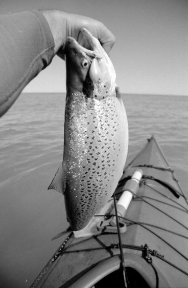
Sunday - Mid-morning, Fishing along the rocky north side of the island in shallow water. Large rocks and shoals make the area disastrous for motorboats. Evening and overnight waves lifted silt and algae into the water giving sport fish an advantage over baitfish. SMASH! An aerobatic 24-inch brown trout tests the limits of the light spinning rig. There is never knowing how much time goes by with a big fish on the line. Too big of a fish for a meal; nursed back, it returns to the foggy gloom below.
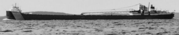
Monday - Up before 5 a.m. to eat and pack. The sun crests the horizon at 6:00, ten minutes ahead of launching away on nice calm water. Passing Vessel Point, Whaleback Ridge comes into view on the horizon at about 123 degrees east-southeast. Leland lies a mile north of the Whaleback. the wind begins slowly rising from the southeast, and a half hour later 1 foot waves begin slapping the deck and puddling on the sprayskirt. Over an hour in, a laker plies up the Manitou Passage; too far away to identify; Dimmick's Point is still to pass by the beam. She is trailed by another laker by ten miles. At 10-13 miles an hour, as lakers go, I may get close enough to the navigation lane to identify the vessel. It is the Arthur M. Anderson, a self-unloading bulk freighter of the Great Lakes Fleet line, famous for providing radar coverage for the crippled and blind Edmund Fitzgerald and being the last vessel in contact with Fitzgerald before its seemly appointed doom in a November 1975 storm. The Anderson was too far away to identify without aid to read the ship's name. It's fleet paint scheme was identifiable from my photo, but Great Lakes Fleet has three sister ships of this class which look identical from afar, the Philip R. Clarke and the Cason J. Callaway being the other two. Luckily, all three carry weather stations which periodically upload wind and temperature data to the internet along with recording time and location. Clarke and Callaway were off Alpena at the time I reached the Manitou Passage. The Anderson left a trail of weather data coming up from Chicago with the last data point recorded at 9:00 UTC (5:00 a.m. EDT) some 30 miles south of the Manitou Passage, which would put it right in the passage at around 8:30 a.m.
The wind and waves gradually subsided away from North Manitou. Leland does not have any significant landmarks, and without an aid, I had to get within two miles of shore to pick out the harbor this first time. The boat ramp was reached at 9:50 a.m. The transit ferries were loading passengers again. Several rangers crowded around the Park Service's boat as it warmed up. A tribal member of the Grand Traverse Band of Ottawa and Chippewa Indians unloaded plastic tubs of fish onto the dock from his rumbling boat. As the Park Service boat backed out to depart, a ranger on board pronounced in Jackie Gleason Show fashion, "And awaaaay we go," and gave the tribal member a chuckling ribbing, "That thing's louder than my Harley!" The drive back downstate was long, but once again I made it on time to work later in the day.