|
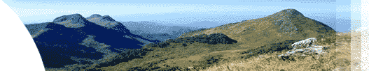
At its height of 1,635 meters, Doi Pha Tung provides a superb
observation point of Thai-Laotain border. The best time of
the year is the cold season when seas of fog cover the valleys
as far as the eyes can see. when the sun is getting higher,
the fog lifts. It gradually melts before our eyes like strams
of white water, disclosing the winding the Mekhong River amikst
the dense forest and green valleys. The pink cherry blossms
from December to January can only add to the daily charm and
beauty of this area.
อยู่ห่างจากเชียงของ 70 กม. (สภาพถนนเป็นหลุมบ่อควรใช้รถกระบะหรือขับเคลื่อน
4 ล้อ) เป็นจุดชมวิวไทย - ลาว สองฝั่งโขง และทะเลหมอกได้ตลอดปีโดยเฉพาะช่วงเดือน
มกราคม - มีนาคม ดอกซากุระและดอกเสี้ยวจะบานสะพรั่งงดงามมาก
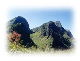
เป็นที่ตั้งของหมู่บ้านชาวม้ง เย้า และจีนฮ่อ โดยเฉพาะจีนฮ่อนั้น
อดีตเคยเป็นส่วนหนึ่งของกองพล 93 ซึ่งอพยพเข้ามาตั้งถิ่นฐานอยู่ที่ดอยผาตั้งนี้
ปัจจุบันประกอบอาชีพทางการเกษตร ปลูกพืชเมืองหนาว เช่น บ๊วย
ท้อ สาลี่ แอปเปิ้ล และชา
การเดินทางจากเชียงราย ระยะทางประมาณ 183 กม. โดยใช้เส้นทางเชียงราย
- เชียงแสน - เชียงของ - ท่าเจริญ - เวียงแก่น-ปางหัด - ผาตั้ง
จุดชมวิวที่สวยที่สุดของผาตั้งอยู่ที่เนิน 103 ซึ่งต้องเดินไปตามแนวเขาอีกประมาณ
1 กม. มีที่พัก และร้านอาหารแบบง่าย ๆ บริการแก่นักท่องเที่ยว
..Go Top
|
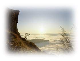
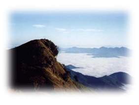
This is the best spot to enjoy the sunrise in Chiang Rai because
of Phu Chi Fa's geographical characteristics. The highest plateau
on top of the mountain is a vast grassy plain extending its
reach over the Laotian border. Its hithest peak is lile a pointing
finger towards the sky. Once on top , the levels of valleys
below spead before our eyes. From here, we can see much further
onto Laos than from any other mountain top. The mountain temperature
in the cold season is very low, and can even be below the freezing
point sime years. Therefore, frosty dews are not uncommon on
top of this mountain. In February , a kind of native white flower
called "Dok Siao" or wild orchid trees are in bloom,
adding to the enchanting charm of the mountain.
To get to Phu Chi Fa, visitors can choose a route uphill according
to their preference. From Ban Phean Din Thong, there is a junction
with two routes uphill to the mounttain top . A much-favored
route id by Ban Rom Fa Thai on the rhght. There are deveral
resort hotels and restaurants on the way. The distance is approximately
1,800 meters to the top. The other route on the left is byn
Ban Rom Fa Thong . There is a roadway up to the office of the
Ngao-Ngao Watersource Management Unit. The walk after that station
is only 800 meters to the top . Both routes are steep.
เป็นจุดชมวิวทะเลหมอกและพระอาทิตย์ขึ้นอีกแห่งหนึ่ง อยู่ห่างจากดอยผาตั้ง
25 กม. มีลักษณะเป็นยอดเขาที่แหลมชี้ขึ้นไปบนท้องฟ้า อยู่สูงจากระดับน้ำทะเลประมาณ
1,628 เมตร โดยมีหน้าผาเป็นแนวยาวยื่นไปทางฝั่งประเทศลาว บนยอดภูชี้ฟ้าเป็นทุ่งหญ้ากว้าง
แซมด้วยทุ่งโคลงเคลงที่มีดอกสีชมพูอมม่วง ซึ่งจะบานระหว่างเดือน
กรกฎาคม - มกราคม
การเดินทาง จากเชียงรายระยะทาง 111 กม. โดยใช้เส้นทางเชียงราย
- เทิง และ เทิง - บ้านปี้ - ปางค่า - เชงเม้ง - บ้านร่มฟ้าไทย
หรือใช้เส้นทางจากเทิง - เชียงคำ แล้วเลี้ยวซ้ายเข้าทางหลวง 1093
ผ่านน้ำตกภูซางระยะทาง 150 กม. หากผ่านเลยไปถึงตัวอำเภอเชียงค
ำอีก 5 กม. มีสถานที่น่าสนใจแวะเยี่ยมชม ได้แก่ศูนย์วัฒนธรรมไทลื้อที่วัดหย่วน
, ศูนย์หัตถกรรมผ้าทอไทลื้อที่วัดพระธาตุสบแวน , วัดพระเจ้านั่งดิน
,อุโบสถไทลื้อ ,วัดแสนเมืองมา และอุโบสถไทยใหญ่วัดนันตาราม แล้วจึงเดินทางต่อไปภูชี้ฟ้าในเส้นทาง
1093 ผ่านน้ำตกภูซาง และบ้านฮวก ( จัดตลาดนัดไทย - ลาว ทุกวันที่
10 , 20 , 30 ของเดือน )
ภูชี้ฟ้า เป็นพื้นที่ในความดูแลของกองทัพภาคที่ 3 มีบ้านพัก 40
หลัง มีห้องน้ำในตัว มีไฟฟ้าและร้านอาหาร นักท่องเที่ยวควรเตรียมอุปกรณ์ของใช้ที่จำเป็นต่าง
ๆ ไปเองและมีสถานที่ตั้งแค้มป์ด้วย |