Suitable for all ages |
Camden Leisure & Community |
CHENIES STREET CHAMBERS
9-11 Chenies Street
London WCI
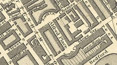
Chenies Street, 1827
USING THE ARCHIVAL MAPS: If you are searching for the location of the land for Chenies Street Chambers through the centuries, make yourself familiar with its location on a modern map, and then search earlier maps for familiar surrounding streets and places (such as the British Museum [1759], Bedford Square, and London University as they are built. Chenies Street runs from Tottenham Court Road to Gower Street. Chenies Street Chambers, 9 -11 Chenies Street , was built in 1888. It adjoins 11 Firzroy House, which adjoins the east of North Crescent on Chenies Street. The building forms the southwest corner of Huntley Street (formerly named Thornhaugh Street).
When searching the archival maps, you will always find Tottenham Court
Road.
Place Names to look
for:
Chenies Street
North Crescent
Alfred Place
South Crescent
Store Street (also known as Great Store Street)
Middlesex Hospital
Whitfield's (or Whitefields) Chapel (on Tottenham Court Road)
British Museum
Russell Square
Bedford Square
Queen Square
If you are in Holborn,
the Holborn Local Archive Centre has an extensive collection of
.maps
MAPS on the
Internet
2000
map of Chenies Street
www.multimap.com
OLD BAILEY CRIMES 1674-1913
http://www.oldbaileyonline.org/forms/formMaps.jsp
LONDON BLUE
PLAQUES
http://www.english-heritage.org.uk/server/show/nav.1499
Booth's 1889
map of Poverty in London
Charles Booth's 1889 Descriptive Map of London Poverty
http://www.umich.edu/~risotto/maxzooms/nw/nwe56.html
The map colour codes the poverty levels of the site of Chenies Street Chambers
as:
comfortable (pink). Fairly comfortable. Good ordinary earnings.
Nearby Tottenham Court Road, North Crescent, Alfred Place, South Crescent,
Store Street and Gower Street are middle class (red). Middle class.
Well-to-do.
Nearby Russell Square, Bedford Square, Tavistock Street, Tavistock Square
and Gordon Square are Upper middle and Upper classes. Wealthy.(yellow)
The closest area of poverty is to the west, in Upper Rathbone Place, and
the most concentrated pocket in St. Giles, to the south.
STANFORD'S LIBRARY MAP OF LONDON
AND ITS SUBURBS 1862
http://www.motco.com/Map/81006
Edward Stanford's 6 inch to the mile map first published in 1862 ,the year
of the International Exhibition. This example is the 1st edition. Access
the map by using the 18,500 segmented place name index, or by clicking on
an overview map.
Section of the Map containing the location of Chenies Street
Map segment 298 (row 13 column 10) from Sheet 10 (row 1 column 4 of sheet).
University College clearly marked
University College Hospital clearly marked
Mortimer Market clearly marked
Huntley street runs from Chenies Street to Pancras Street. The street carries
on north of Pancras Street, and runs to Grafton street, but is called Sussex
Street.
John
Snow's 1859 map of London
overview
http://www.ph.ucla.edu/epi/snow/1859map/map1859_g-l_19-24.html
neighbourhood
http://www.ph.ucla.edu/epi/snow/1859map/map1859_g-l_19-24.html
Chenies Street runs from Tottenham Court Road, past North Crescent.
The first though-road is Alfred Street (which was called Thornhaugh
earlier, and will later change its name to Huntley Street north of Francis
Street).
The next street is not named .
The street where Chenies Street ends, to the east, is Gower Street.
Running north, on Tottenham Court Road, east side, the streets are:
Chenies Street (jogging southwest at Tottenham Court Road to join Goodge
Street)
Francis Street (runs directly west to the chapel grounds). Torrington Place
runs directly into Francis Street
Pancras Street (jogging slightly south west at Tottenham Court Road to join
Howland Street)
University Streeet (running directly into London Street on the west side
of Tottenham Court Road
Dickens
London Map
http://www.fidnet.com/~dap1955/dickens/dickens_london_map.html
Clicking the button on the locations below will take you to that section
of an 1859 map of London, courtesy of UCLA, and created by Ralph R. Frerichs.
From the map, further detail is available.
An annotated list of Dickens areas, accompanying the John Snow's 1859 map
of London
PLACE NAMES TO LOOK FOR:
British Museum
Seven Dials (St Giles Circus)
Tavistock House
Tottenham Court Road
1857 map of Tollgates
and Bars Within Six Miles of Charing Cross
http://www.londonancestor.com/maps/tolls-ce.htm
Copy of Map showing the Toll-Gates and principal Bars within six miles of
Charing Cross, exhibited to Lord Palmerston by the Toll Reform Committee.
The whole of the side-bars are not shown: they are upwards of one hundred
in number.
PLACE NAMES:
Oxford Street
Kings Cross
useful overview of built up area but no details (Tottenham Court Road not
named; Euston Road named "New Road"
1830 map of London
http://www.motco.com/Map/81003/
Placenames listed:
Alfred Place (7,9)
Store Street
GREENWOOD MAP OF LONDON Second Edition 1830 (8 inches to a mile)
Map segment row 7, column 9 from Sheet 1
&
http://www.motco.com/Map/81003/
GREENWOOD MAP OF LONDON Second edition 1830 (8 inches to a mile)
Map segment row 6, column 9 from Sheet 1
Note: The street running north from Francis Street, formerly called "Upper
ThornhaughStreet" is now called Huntley Street. Huntley Street stops
at Francis Street, and the street now on the east side of our building (now
called Huntley Street) is "Thornhaugh Street"
The street at the junction of Chenies Street immediately east of
"Thornhaugh Street" is "Chenies Mews"
Greenwood's
Map of London 1827
http://www.bathspa.ac.uk/greenwood/map_c4h.html#bottom
Note: "North Crescent" and "South Crescent" have been built.
The street leading off South Crescent, "Store Street" is no longer called
"Great Store Street"
The street running north from Francis Street (now called Huntley Street)
is called "Upper Thornhaugh Street", and the street now on the east side
of our building (now Huntly Street) is "Thornhaugh Street"
Chenies Street connects with Tottenham Court Road to the west and Gower
Street to the east. It is slightly north of parallell with Goodge Street.
Francis Street, Pancras Street, a street not named, which seems to run through
Mortimers Market to Thornhaugh Street
Carmarthon Street (joining London Street on Tottenham Court Road's west side)
Grafton Street East (joining Graft Street on Tottenham Court Road's west
side)
Upper Thornhaugh Street ends at Grafton Street East
Middlesex Hospital is bounded by Charles Street to the south, Upper Newman
Street to the east, Nassau Street to the west, and Union Street to the north.
Covent Garden Workhouse is in the southwest part of the square formed by
Charlotte Street and Howland Street, at the junction of Queen Anne Street
(renamed Foley street by 1859) and Cleveland Street .
There seems to be a road running directly south from the east side of North
Crescent, not named but running down the east side of Alfred Place.
NOTE: from the History of Greenwood's Map © Mark Annand
Greenwood's map published, from a survey carried out in the preceding
two years. The first edition copy used for this resource has been loaned
from a private collection. Several versions of this first edition exist,
changes include those to detail in the zoological gardens, the appearance
of proposed collier docks on the Isle of Dogs, also a copy exists showing
a circus in place of Park Square near Regent's Park. The following notice
appeared in the Times on the seventh of November indicating that Greenwood
although completing the survey was having difficulties with the production
of the map.
"Greenwood's Map of London. The subscribers to the work are most respectfully
informed that although the publication took place some months ago, it will
be impossible for the proprietors (through the medium of their agents) to
effect the whole delivery for several months; those subscribers, therefore,
who have not already received their copies, and who would prefer to receive
them earlier than through the regular course of delivery, are requested to
apply at the office, 1 Regent Street, Pall Mall."
Leigh's New Map
of the Environs of London.
London, Published by Samuel Leigh, 18, Strand.
Drawn and Engraved by Sidy. Hall, 14, Bury St. Bloomsby.
Published 1819.
http://www.londonancestor.com/map-leigh.htm
overview map, showing built up areas.
JOHN FAIRBURN - MAP OF LONDON AND
WESTMINSTER AND THE NEW DOCKS 1802
http://www.motco.com/Map/81004
http://www.motco.com/Map/compare
First published in 1795, 3 3/4 inches to a mile, this example is the 7th
edition published in 1802 and includes the additional righthand section,
first added in 1801, showing the West India Docks. With commentary by Ralph
Hyde Access the map by clicking on an image of the complete map, or by using
the 2000 place name index.
Chenies Street connects with Tottenham Court Road. North Crescent, South
Cresent and Alfred Place are in evidence.
There are gardens following the crescents in North Crescent and South Crescent,
and Gadens to the west of Alfred Place, between Alfred Place and Tottenham
Court Road (as well as gardens to the back of the east side of Alfred Place).
Thornhaugh Street ("Thrauhaugh Steet?" - the spelling is obscured) seems
to run to the south of Chenies Street, and there are a small collection of
separate buildings to the south of Chenies Street, which aren't identified.
Store Street is called Store Street
TO THE WEST
Mortimer Street runs east until the Wells street bilateral, where the road
angles up through Charles Street (at a northeast angle) to join Goodge Street.
Charles Street ends Berners Street to the north, cuts through Newman Street,
and ends there.
Goodge street runs from Newman Street to Tottenham Court Road.The roads on
its south side running off it are Rathbone Place, Charlotte Street (which
it crosses), John Street (which it crosses) and it ends at Tottenham Court
Road.
On this map, which doesn't list passages, Marybone Passage isn't marked.
There appears to be a large building, not named bounded by Charles Street
to the south, Newman Street to the east, the street to the east of Wells
street to the west, and Union Street to the north. This appears to be the
site of the Middlesex hospital (circa 2000) although there is no Union
street, note: in the 1802 map, Newman Street changes its name to Cleveland
Street on the north side of present-day Goodge Street, at the junction with
Tottenham Street.
There is no marking of a building at the site of the 1742 Middlesex County
Hospital.
TO THE NORTH
There is no University.
Mortimers Market is on the east side of Tottenham Court Road, north from
Chenies Street, Francis Street, Pancras Street, in front of a large field
which bounded by Tottenham Court Road to its west, Pancras Street on its
south side Upper Gower Street on its east, and Tottenham Place (slightly
north of being parallell to Warren Street) on its north side.
Mortimers Market is in its own road, which is on the east side of Tootenham
Court Road, but appears to be about half the distance between Howland Street
and Warren Street.
The continuation of "Thornhaugh Street" to the north of Francis Street runs
at a slight angle to the northeast, and appears to not be as wide as the
marked "Thornhaugh Street" which runs between Francis Street and Chenies
Street.
The roads with Thornhaugh Street crosses are Chenies street, then, to its
north, Francis Street, then (the Thornhaugh street is unnamed, but it continues,
and ends at St. Pancras Street, the north side of which is a field.
The streets running north from Chenies Street, from Tottenham Court Road,
are: North Crescent, Thornhaugh, Chenies Street Mews and Gower Street, where
Chenies Street ends.
Bedford Square and Russel Square have been built.
TO THE SOUTH
On the West Side of Tottenham Court Road
Streets leading off Tottenham Court Road running east-west, from:
Percy Street, then to the north
Windmill Street (parallel to South crescent and Store Street on the east
side of Tottenham Court Road
an unnamed street, leading to a square
Goodge Street (jogging north to join North Crescent and Chenies Street on
the east side of Tottenham Court Road)
Tottenham Street (jogging north to join the back curve of North Crescent,
called Alfred Mews)
an enclosed square, not named
Howland Street (jogging north to join Pancras Street)
London Street (jogging north to join the street which ends in Moritimers
Market)
a dead end, not named
Grafton Street
Market Street
Warren Street (jogging north to join Tottenham Place)
RICHARD HORWOOD - MAP OF LONDON,
WESTMINSTER AND SOUTHWARK SHEWING EVERY HOUSE 1792-9
http://www.motco.com/Map/81005/
place name:
Chenies Street (5,11)
HORWOOD MAP OF LONDON, WESTMINSTER & SOUTHWARK 1792-9 First edition (26
inches to a mile) Section of the Map containing the location of Chenies
Street
Map segment 171 (row 5, column 11) from Sheet C1 (row 5, column 1 of sheet).
Chenies Street is a dead end to the west, ending roughly where the
present-day North Crescent begins, and not connecting with Tottenham Court
Road. Chenies Street ends at Gower Street.
To the south of Chenies Street, North Crescent, South Crescent and Alfred
Palce haven't been built yet, there are several outbuildings instead, for
Cox's Garden.
SOUTH OF CHENIES STREET (Including Great Store Street)
Map segment 211 (row 6, column 11) from Sheet C2 (row 1, column 1 of sheet).
WEST OF CHENIES STREET
Map segment 170 (row 5, column 10) from Sheet B1 (row 5, column 5 of sheet).
Whitfields Chapel is clealy marked on the West side of Tottenham Court Road,
bounded by Chapel Road.
Longmans and Broadreip (some sort of firm) is on the East side of Tottenham
Court Road
Jones, Taylor & Co. Manufactory is further up on the East Side of Tottenham
Court Road, above Francis Street.On Francis Street, before you get to Tottenham
Court Road, there is a timber yard.
SOUTHWEST OF CHENIES STREET
Map segment 210 (row 6, column 10) from Sheet B2 (row 1, column 5 of sheet).
Charlotte Chapel is at the West end of Windmill Street. No windmill is in
evidence.
Goodge Street runs into Tottenham Court Road.
J. CARY'S MAP OF 15 MILES ROUND
LONDON 1786 First Edition (1 inch to a mile)
http://www.motco.com/Map/81001
Page 25. Map size without border 148 x 88mm
PLACE NAMES IN INDEX:
Pancras
Kentish Town
Battle Bridge (near modern day King's Cross Station)
Foundling hospital is illustrated. Built up areas around east side of Tottenham
Court Road, but still fields to the northeast.
JOHN ROCQUE LONDON, WESTMINSTER
AND SOUTWARK First Edition 1746 (26 inches to a mile)
http://www.motco.com/Map/compare
There are only fields where Chenies Street Chambers will be built.
PLACE NAME:
Tottenham Court Road
Section of the Map containing the location of Tottenham Court Road
Segment 54 (Sheet B1, section 9)
There is no Goodge Street; not even a lane following its contour(all the
lanes running off Mortimer Street, to the east. run northwest). Mortimer
Street is well-built, though, and three paths fork off from it where it joins
Marybone Place
Marybone Passage starts just east of Rathbone Place on Oxford Street (Segment
54 (Sheet B1, section 9), after Stable Yard.. It runs from Oxford Street,
through fields, crosses Berners Street where Marybone Place startson the
north side, runs through fields, to come out slightly to the north
of Eastcaste Street (where it is still named), and then into Great Tichfield
Street.
Middlesex County Hospital is at the end of Windmill Street (where the Charlotte
Chapel appears in 1792)
Slightly to the north of Windmill Street is the Red Lyon Inn
Slightly to the south of Windmill Street is a large Stable Yard
Directly to the east of Windmill Street, on the east side of Tottenham Court
Road, (now the location of Store Street) is a large Timber Yard, and
immediately adjacent to it, on the south side (and still on east side
of Tottenham Court Road) is a Pound.
Rathbone Place is built, with Black Horse Stable Yard running off its east
side.
TO THE NORTH:
JOHN ROCQUE LONDON, WESTMINSTER AND SOUTHWARK First Edition 1746 (26 inches
to a mile)
Segment 30 (Sheet B1, section 6)
A few buildings on the West Side of Tottenham Court Road. No Whitfields Chapel.
TO THE WEST:
JOHN ROCQUE LONDON, WESTMINSTER AND SOUTHWARK First Edition 1746 (26 inches
to a mile)
Segment 53 (Sheet B1, section 8)
To the west of the Middlesex County Hospital is the Merchants Waterworks
Marybone Passage is evident.
Middlesex county hospital seems to have a northern street or passage, running
roughly along the same direction as if it were a continuation of Windmill
Street
16th
Century Tudor England
Medieval Atlas - Maps of London
An index of maps depicting London throughout the Middle Ages.
http://historymedren.about.com/library/atlas/blatlondex.htm?iam=dpile&terms=London+Maps
A screen-size map of the city in the 16th century is accompanied by a much
larger version suitable for printing at the Compendium of Common Knowledge.
Downloading the larger map for printing from a graphics program is recommended.
large map:
http://historymedren.about.com/gi/dynamic/offsite.htm?site=http://renaissance.dm.net/compendium/map%2Dlondon.html
PLACE NAMES:
St. Giles
The City of London ends at St. Giles. Only fields to the North of St. Giles
OTHER SEARCHES:
OLD BAILEY CRIMES 1674-1913
http://www.oldbaileyonline.org/forms/formMaps.jsp
LONDON BLUE
PLAQUES
http://www.english-heritage.org.uk/server/show/nav.1499
CHENIES STREET CHAMBERS
website
formed September 2001
![]()
approved
(suitable for all ages )