 |
|
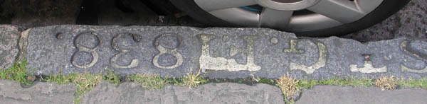
1838 St. Giles in the Fields boundary kerbstone
(east side of Huntley street, north of Chenies street)
photographer: Richard Carpenter
June 2002
HISTORICAL BACKGROUND
The kerbstones which serve as boundary markers are important because the parish boundaries moved at various times through the centuries. The St Giles-in the Fields parish boundary marker on the east side of Huntley Street, south of Torrington Place, is particularly interesting because it is dated 1838, which conclusively establishes the boundaries at that date (a later Survey of London states the boundary was north of Francis Street, not south, as this kerbstone suggests).
BOUNDARY MARKERS FOR THE PARISH OF ST. GILES-IN-THE-FIELDS
(taken from the London County Council Survey of London, 1914)
The earliest mention of the parish boundary of St. Giles-in-the-Fields occurs in a decree of 1222, terminating the dispute between the Abbey of Westminster and the See of London respecting the ecclesiastical franchise of the conventual church of St. Peter. According to this the boundary of the Parish of St. Margaret, Westminster, began at the watercourse of Tyburn and stretched towards London as far as the garden of the Hospital of St Giles, "thence as the way beyond the same garden extends as far as the boundaries dividing Marshland and the parish of St. Giles. This is pretty clear evidence that in those early days the southern portion of the western boundary of St. Giles passed along the throughfare bounding the Precinct and Marshland on the west, thus agreeing precisely with the limits of the present day.
Although, however, there does not seem to have been any change in that comparatively small part of the parish boundary, in many other respects the limits of the parish have undergone serious modification. The first considerable alteration took place in 1731, when the Parish of St. George, Bloomsbury, was formed out of the old parish, and made to include all that part which lay to the north of High Holborn and east of Dyot Street and of a line drawn northwards from the latter's termination in Great Russell Street. (SEE plate 6 Plan of the Parishes or Division of St Giles in the Fields and St George Bloomsbury 1815). This northward line was afterwards slightly modified. Again, quite recently, the parish was further curtailed as a result of Orders made under the London Government Act, 1899. The south side of Lincoln's Inn Fields, and the area lying between Wild Street and Drury Lane, were thereby taken from St. Giles, a give-and-take line was adopted between the west side of Lincoln's Inn Fields and the junction of Kemble Street and Wild Street and certain small additions to the parish were made at Francis street on the north and Broker's Alley on the south.
The boundary between the parishes of St. Giles in the Fields and St. George, Bloomsbury, cuts through Bedford Square in such a way that although the greatest part of the square is in the former, all the houses on the east side and a few on the south side are in the parish of St. George.
London County Council Survey of London
Volume 5
The Parish of St. Giles in the Fields (part 11)
London County Council 1914
1815: Parish Boundary for St Giles in the Fields
NORTH BOUNDARY:
Francis Street (now called Torrington Place)
The first true intersecting point, from the start 120 feet south of Francis Street and Tottenham Court Road, is at the north east corner of Hunter Street and Compton Road. The boundary extends fifty feet to the north and then the north-east boundary corner turns south at a right angle .
The North Boundary crosses the various streets running north south at the following points:
From Francis Street (now called Torrington Place):
Roughly 120 feet south of the south-east corner of Francis Street and Tottenham Court Road
Thornhaugh Street (now called Huntley Street):
Roughly 70 feet south of the south-west corner of Thornhaugh Street
Roughly 60 feet south of the south-east corner of Thornhaugh Street (kerbstone in place: 'St. Giles 1838'
Chenies Mews:
Roughly 50 feet south of the south-west corner of Chenies Mews
Roughly 45 feet south of the south-east corner of Chenies Mews (possibly kerbstone in place, slightly to the south of the entrance to flats 49 - 63 of ridgmount Gardens. Obscured, and weathered but the kerbstone has what looks like a carved cross on its right hand side).
Gower Street:
Roughly 40 feet south of the south-west corner of Gower Street
Roughly 30 feet south of the south-east corner of Gower Street
Keppel News North
Crosses the south-west corner of Keppel Mews North
There are roughly 400 feet between the junction of south-east corner of Francis Street and Tottenham court Road to the junction of Francis Street and the south-east corner of Thornhaugh Street.
Roughly 630 feet between the junction of Thornhaugh Street and the NORTH-EAST boundary of the parish, which is north of Keppel Mews north (an field in 1815).
EAST BOUNDARY: (please note: this 'Charlotte Street' has been renamed Bloomsbury)
The east boundary begins roughly 1030 feet east of the south-east junction of Francis Street and Tottenham Court Road and it is also roughly 50 feet north of the north-east corner of Gower Street and Francis Street, roughly 370 feet to the east of it (roughly following the contours of Francis Street, had it continued at this period). From this North-east corner, it curves down, crossing Keppel Mews North at a point roughly 560 feet south of the south-east junction of Keppel Mews North and Francis Street. It crosses the junction of Keppel Mews North on the west side roughly 600 feet south of the junction of Francis Street and the south-west corner of Keppel Mews North.
It crosses Montague Place at roughly 40 feet from the junction of Charlotte Street and the north-east corner of Montague Place and the junction of Charlotte Street, and, on the south-east corner of Montague Place at the junction of Charlotte Street, it is roughly 10 feet from the junction.
It continues down Bedford Square, cutting at the west property boundary of the last house on the
South side of Bedford Square, before Charlotte Street.
It crosses Caroline Mews on the north side roughly 65 feet west of Charlotte Street.
It crosses Caroline Mews on the south side roughly 70 feet west of Charlotte Street
It crosses Great Russel (sic) Street on the north side roughly 150 feet west of the junction with Charlotte Street.
On the south side of this street, it continues down a lane, which crosses New Street, the junction of Baynbridge Street and Streatham Street, Buckeridge Street , Church Street, Phoenix Street and finally, when it joins Broad Street, it runs east along Broad Street, Holborn and then turns south about 50 feet East of Hand Court, to include part of Lincoln's Inn Gardens. It runs south about 720 feet from Hand the point east of Hand Court.
SOUTH-EAST CORNER
Starts 130 feet east of the junction of Searle Street and the south east corner of Lincoln Inns Fields.
SOUTH BOUNDARY.
Curves from its south-east corner, through the Royal College of Surgeons, crosses Portsmouth Street, sheffield street, Black Horse Yard,Duke Street, Great Wild Street, crosses Stanhope Street, and joins Drury Lane at the junction of Russell Street, and goes north along Drury Lane.
It crosses Dukes Court, Broad Court, Longacre, Broker's Alley, and then, about 30 feet north of broker's alley turns west and after 200 feet running west, along the back of the houses on the north side of Broker's Alley, it rejoins Castle Street, and goes down to the southern tip of the seven Dials, to the junction of Little St. Martin's Lane and Little St Andrews Street.
From there, it begins its west boundary, joining West street.
WEST BOUNDARY:
South west corner: meeting of Lichfield Street (west) West Street (diagonally north) and the junction of Little St. Martin's Lane and Little St. Andrew Street.
Going north, following up West Street, past the junction of Church Street and Monmouth Street, continuing north on West Street as it joins Crown Street (at the junction of Compton Street and New Compton Street) and continuing north up Crown Street, until it jogs to the east and turns into Tottenham court Road at the Junction of Oxford Street(west), Baynbridge Street (east) and High Street (south). Up Tottenham court Road to roughly 120 feet south of the south east junction of francis Street with Tottenham Court Road.
From there it curves to the North, forming the North Boundary.
London County Council Survey of London
Volume 21
Tottenham Court Road and St Pancras
London County Council 1949
P 77.
LX - Torrington Place
(formerly Francis Street, west of Gower Street)
Since January, 1938, the road turning out of Tottenham Court Road to the east and connecting it with Byng Place and Gordon Square has been known as Torrington Place, the name formerly borne by the eastern section only. The portion west of Gower Street was until then known as Francis Street.
Torrington Place was, as already stated, built on Cantlowes Close and the present boundary between the parishes of St. Pancras and St. Giles-in-the-Fields runs along its centre, marking the southern limit of this part of the borough of St. Pancras. Formerly, the parish boundary ran some way north (? I think the writer meant south. The boundary is clearly marked as south of Francis Street on the 1815 map) of the former Francis Street and approached Torrington Place at its eastern end,
"As of 1949, there [were] only two old houses left on the north side of the former Francis Street. No. 12, a large house of early 19th century date, of four storeys with an arched doorway flanked by two windows on each side, and a similar house to the east which has two shops and is much damaged. Between the houses is an archway leading to the Yard behind. Huntley Street crosses the Street and continues north and south of it.
"Further east, between Upper Gower Mews and Byng Place, [were ] two late 18th century houses, Nos. 33 and 35, of stock brick, four storeys in height, having a stucco entablature between the two top floors. The eastern house has a good shop front on both south and east sides with a doorway at the corner. The facia has a modillion cornice and there is an excellent ornamental cast-iron balustrade forming a continuous balcony above."
 |
If you live in Camden and you are concerned about roadworks and their effects on your kerbstones or paving stones, please contact Mr. Frano Combrinck. (In particular, if there will be any building or demolition going on in the near future in your street, replacing paving stones will be ineffectual, since the building site may well damage the new paving, as well as the old, and Mr. Combrink would like to know about it before work begins).
Frano Combrinck
Engineering and Traffic
London Borough of Camden
Bedford House
125 Camden High Street
London NW1 7JR