Landslides become a hazard since they cause the damage or lost of natural landscape, human living, and infrastructure. It has become one of the world's major disasters for the past few year in many countries. Globally, landslides cause approximately 1000 deaths a year with property damage of about US$4 billion (ISU, 1993).
- Erosion by rivers, glaciers, or ocean waves create oversteepened slopes
- Rock and soil slopes are weakened through saturation by snowmelt or heavy rains
- Earthquakes create stresses the make weak slopes fail
- Volcanic eruptions produce loose ash deposits, heavy rain, and debris flows
- Excess weight from accumulation of rain or snow, tick[illing of rocj or ore, from waste piles, or from man-made strctures may stress weak slope to failure and other structures
One of the earliest forms of research on landslide was landslide inventory. Inthis stage the distribution and the style of landslide are desribed in detail. The result of this study was normally a detail description of each landslide with the single map. A slope instability map is normally created as the next study to improve the understanding in slope instability. This map represents a particular form of terrain analysis map.To investigate the landslides in relation with their probability of occurences, the hazard zonation or hazard susceptibility map must be established in different scales. The prediction of the potential landslide hazard for areas not concurrently subject to landsliding is based on the assumtion that hazardous phenomena the have occurred in the past can provide useful information for prediction of future occurences (van Westen, 1996). When people are going to consider the hazard affecting human life having economic effects or causing environment change, the use the term "risk" and "vulnerability".
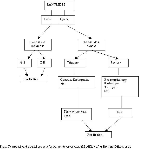
The flowchart belowing shows the recent trend of landslide prediction.