|
|
|
|
|
|
|
|
|
| North and South Manitou Islands |
|
| Day 1 (Sunday 7/16/00) |
| I first backpacked on South Manitou island in 1987, travelling to the island via the passenger ferry from Leland Michigan. Over the years, I have experienced ferry crossings where the waves in the Manitou Passage seemed higher than the upper ferry deck. Many passengers on the tossing ship became seasick as the waves crashed over the deck and into the boat`s cabin. I gained a healthy respect for the Manitou Passage, but I also gained a fascination with paddling in these shipwreck strewn waters. |
|
| Three years ago, I built a cedar strip sea kayak in my basement. One snowy evening in January, I loosely placed the finished deck on the finished hull. Then, sitting in the cockpit of the partially built boat, I thought of my goal of one day paddling the 8.5 mile crossing to the South Manitou island from Glen Haven, MI. I imagined what the bow would look like slicing through the waves. |
|
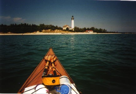
| Last July, I realized my goal when Paul and I paddled to South Manitou Island for a week long trip. The 10 knot Northwest wind pushed the waves to about 3 feet. I watched the bow slice through each wave as the island drew neared. The favorable conditions allowed us to make the crossing in 2hrs and 15 minutes. I savored the moment as my bow finally touched the sandy island beach. I especially savored the sight of Paul falling into the water as he tried to climb from his expedition-small cockpit. Paul had also built a cedar strip kayak. We enjoyed answering the usual questions from backpackers on the island: "Did you paddle all the way from the mainland?" and "Did you make those boats?" |
|
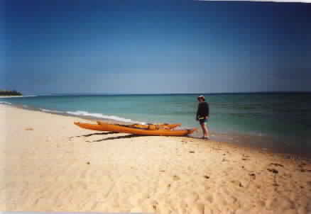
| In Lake Michigan, South Manitou island is part of the Sleeping Bear Dunes National Lakeshore. Low impact backcountry camping is required on the wilderness island. At the park headquarters in Empire Michigan, we voluntarily filled out a trip itinerary showing our intended destination to South Manitou Island and our expected time of arrival. Before we left the park office, the Ranger had already called the island and told them to expect us. Then, when we reached the island, we checked in at the island Ranger Station to confirm our arrival. Paul and I were grateful for the added measure of safety that the park service went out of their way to offer. With the Ranger`s permission, we parked our vehicle at the Cannery (vintage boat museum) in Glen Haven. This offered an ideal sandy beach launch site. |
|
|