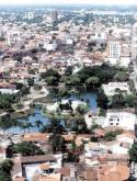
SANTA CRUZ de la Sierra
[Map]
[History]
[Climate]
[How to Get There]
[Main Attractions]
History
The city of Santa Cruz de la Sierra was founded by �uflo de Ch�vez on February 26, 1560. Ch�vez named the new city in honor of his beloved native city in Extremadura, Spain. The city originally lay 220 km east of its current location, on the shores of the Pira� river. But, by the end of the 16th century, the city was moved to its present position, 50 km east of the Cordillera Oriental foothills.
Santa Cruz supplied the rest of the colony with cotton, rice, sugar and fruit. It was a prosperous city until the late 1800's. Then, transport routes opened up between Peru's sea ports and La Paz, making imported products cheaper than those transported by mule from Santa Cruz.
In the 1950's Santa Cruz was connected through roads and highways with other major centers. Also the completion of the railway line to Brazil in the mid-1950s opened trade routes to the east. Tropical agriculture (sugar, rice, cotton, and soybean plantations) prospered and the city entered a period of expansion and economic growth that continues to the present day. The city is connected by railways with Brazil and Argentina, and by road with Cochabamba, the Chaco, and Trinidad.
By November 1996, according to data from the Instituto Nacional de Estad�stica (INE), the city of Santa Cruz de la Sierra had a population of 904,376 inhabitants.

Climate
Located an altitude of 416 meters above sea level, Santa Cruz has a sunny and semi-tropical weather, with an average temperature of 21C (70F) on winter and 32C (90F) on summer. During winter, rainfall occurs in short downpours, but on summer a single deluge can last for days. Santa Cruz also experiences heavy and chilly winds called surazos that blow in from the Argentine pampas.
How to Get There
By land:
From Cochabamba (through Chimor� - Yapacani): 469 Km by rubble and asphalt road'
From Cochabamba (through Epizana): 500 Km by rubble and asphalt road
From Trinidad: 550 Km by rubble and asphalt road
From Sucre: 610 Km by rubble and asphalt road
From Puerto Su�rez (Brazilian border): 591 Km by rubble and asphalt road
By train:
Pocitos (Argentina) - Yacuiba - Santa Cruz
Corumb� (Brazil) - Puerto Su�rez - Santa Cruz
By air:
From any main city in the country
Main Attractions
Pira� River: The riverbanks are ideal for weekend picnics
Municipal Zoo: One of the best zoos in South America, features birds, reptiles, mammals, from the region as well as endangered and exotic species.
Plaza 24 de Septiembre: Ideal for relaxing and watching sloths hanging in the tall trees.
The Cathedral: Located on the Plaza 14 de Septiembre, the cathedral dates back to the early 1600's. The cathedral museum displays religious art work, gold and silver artifact from the Jesuit missions.
Museo de Historia Natural: Display a collection of flora and fauna of the region.
Lomas de Arena de El Palmar: Located 16 Km south of Santa Cruz these large sand dunes and fresh water lagoons are ideal for weekend picnics and swimming.
