CONTENT CENTER
(PANGAEA TO THE PRESENT )
Lesson # 2
Plate Tectonics
(The Continental Drift Theory)


Earthquakes, volcanoes, and mountains are all produced by the same natural processes. We know this to be true today, but even as little as one hundred years ago scientists were unsure as to how these geologic processes occurred.
 
The ancient Japanese legend of Namazu explained why earthquakes occur this way. Namazu was a giant catfish that lived under the surface of the Earth. It would shake violently and cause great destruction from time to time. Kashima, who is a Japanese god, was the only god that was strong enough to control Namazu. Kashima would hold Namazu down and pin the catfish under a rock. When Kashima's mind would wonder, Namazu would escape and cause another earthquake.
 
Many cultures have tried to explain why earthquakes and volcanoes occur through stories about their gods and goddesses. The Hawaiian Islanders thought that volcanoes were the home of the fire goddess Pele. The Romans believed that the blacksmith god, Vulcan, used volcanoes as his forge to produce weapons.
 
For hundreds of years people throughout the world explained earthquakes and volcanoes through myth and legend. In 1620 however Sir Francis Bacon of England declared that it was not gods and goddesses that caused natural disasters. He noticed how the coasts of Africa and South America were very much alike. In fact they could almost fit together like pieces of a jigsaw puzzle. The map on the next page shows how the two continents could fit together.


As humans traveled the world they noticed seashells high in mountains many miles from the nearest ocean. Why is there a similarity between the coasts of Africa and South America? How did those seashells end up high in the mountains? These questions along with new discoveries lead scientists to believe that the Earth is a dynamic, or constantly changing planet. It was not until the 1960's though, that scientists started to agree to the concept that the continents could move across the surface of the Earth.
 
A German meteorologist by the name of Alfred Wegener showed that rock bands in South America and rock bands in Africa matched mineral content and by age exactly. He also showed that the magnetic bands in these same rocks did not point to the magnetic north pole as they should. If the continents could be moved back into the position that they were created, then they do point to the magnetic north pole. Wegener concluded that the continents must have drifted apart hundreds of miles. He did not however have an explanation as to how these massive continents could move such a great distance.
It was not until the 1960's that geologists gained the technology to fully understand the processes that could move the Earth's plates. They concluded that the Earth's surface was composed of not one large sheet but was composed of more than twelve major pieces of crust. Geologists call these pieces plates . These plates float across the surface of the Earth like an iceberg floats on the ocean. The driving force behind these plate movements are the convection currents in the mantle. The convection currents turn very slowly dragging the plates along with these movements. The convection currents move the plates very slowly. These plates move at only 1 to 4 inches per year!!
 
The lines on the map of the world on page 4 indicate the position of the plate boundaries. Boundaries are places where the plates meet.
Now geologists can finally explain the reasons that mountains are built, volcanoes erupt, and earthquakes occur. The Plate Tectonics Theory of continental movement can explain scientifically why all of these geologic processes can occur. Humans no longer have to try to explain these natural occurrences through myth and legend.


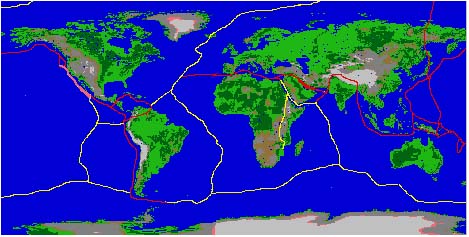
Plate tectonics: The main features are:

  • The Earth's surface is made up of a series of large plates (like pieces of a giant jigsaw puzzle).
  • These plates are in constant motion traveling at a few centimeters per year.
  • The ocean floors are continually moving, spreading from the center and sinking at the edges.
  • Convection currents beneath the plates move the plates in different directions.
  • The source of heat driving the convection currents is radioactive decay which is happening deep in the Earth.
plates

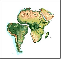
It is hard to imagine that these great big solid slabs of rock could wander around the globe. Scientists needed a clue as to how the continents drifted. The discovery of the chain of mountains that lie under the oceans was the clue that they were waiting for.

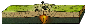
PLATES ARE CREATED: In the diagram below you can see that the continental crust is beginning to separate creating a diverging plate boundary. When a divergence occurs within a continent it is called rifting. A plume of hot magma rises from deep within the mantle pushing up the crust and causing pressure forcing the continent to break and separate. Lava flows and earthquakes would be seen. In the diagram below you can see that the continental crust is beginning to separate creating a diverging plate boundary. When a divergence occurs within a continent it is called rifting. A plume of hot magma rises from deep within the mantle pushing up the crust and causing pressure forcing the continent to break and separate. Lava flows and earthquakes would be seen.
diverge plates animation.gif (16916 bytes) This is an example of a divergent plate boundary (where the plates move away from each other). The Atlantic Ocean was created by this process. The mid-Atlantic Ridge is an area where new sea floor is being created.


diverge plates with opening rift valley animation.gif (18569 bytes) 
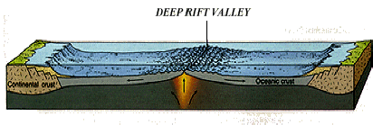
As the rift valley expands two continental plates have been constructed from the original one. The molten rock continues to push the crust apart creating new crust as it does.


diverge3 animation  widening ocean.gif (17635 bytes) As the rift valley expands, water collects forming a sea. The Mid-Atlantic Ridge is now 2,000 metres above the adjacent sea floor, which is at a depth of about 6,000 metres below sea level.


diverge4 animated sequence.gif (25011 bytes) The sea floor continues to spread and the plates get bigger and bigger. This process can be seen all over the world and produces about 17 square kilometres of new plate every year.


Review Questions


  1. In your own words explain what the Continental Drift Theory states.
  2. In your own words explain what sea floor spreading states.
     
  3. How did Alfred Wegener try to prove that the continents of Africa and South America were once connected?
     
  4. How did the ancient people of Japan explain earthquakes?
     
  5. How did the ancient Romans explain the presence volcanoes?
     

 To VolcanoWorld

Hosted by www.Geocities.ws

1