
|
Riding
at Strawberry Mountain
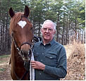
By Larry Wheat
 A
few of the CCSC club members have shared rides with me on the Horn Mountain
section of the Georgia Pinhoti Trail (GPT). The Dry Creek and John’s
Mountain section of the GPT lies to the immediate west of the Horn Mountain
section. And the next section of the GPT to the southwest of Dry Creek
is Strawberry Mountain, unfortunately separated from Dry Creek by about
one mile of road. The three sections mentioned, and other adjoining
sections, reside on the National Forest. The GPT traverses Strawberry
Mountain providing 4.4 miles (each direction) of safe Level 1 ride opportunity.
There is a parking lot suitable for parking 6-10 horse rigs, and a trout-fishing
stream beside the access road and parking area. A further benefit is
that the parking lot is accessible using asphalt roads–a benefit
not common in the Armuchee-Cohutta Ranger District.
A
few of the CCSC club members have shared rides with me on the Horn Mountain
section of the Georgia Pinhoti Trail (GPT). The Dry Creek and John’s
Mountain section of the GPT lies to the immediate west of the Horn Mountain
section. And the next section of the GPT to the southwest of Dry Creek
is Strawberry Mountain, unfortunately separated from Dry Creek by about
one mile of road. The three sections mentioned, and other adjoining
sections, reside on the National Forest. The GPT traverses Strawberry
Mountain providing 4.4 miles (each direction) of safe Level 1 ride opportunity.
There is a parking lot suitable for parking 6-10 horse rigs, and a trout-fishing
stream beside the access road and parking area. A further benefit is
that the parking lot is accessible using asphalt roads–a benefit
not common in the Armuchee-Cohutta Ranger District.
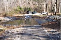 The
photo below was taken from the main parking lot, looking across the
West Armuchee Creek. The access road intersection is just 100 feet beyond
my truck and horse trailer. There is room to park a couple of horse
trailers along the access road before crossing the creek. To get to
the main parking lot you need to drive across the creek. There are concrete
slabs placed on the streambed to form a safe creek crossing.
The
photo below was taken from the main parking lot, looking across the
West Armuchee Creek. The access road intersection is just 100 feet beyond
my truck and horse trailer. There is room to park a couple of horse
trailers along the access road before crossing the creek. To get to
the main parking lot you need to drive across the creek. There are concrete
slabs placed on the streambed to form a safe creek crossing.
Unless you are riding with someone familiar with the network of unofficial trails, I recommend that you ride the Pinhoti Trail from the parking lot to the edge of the USFS land, at county road 706. This is a one-way distance of 4.4 miles. Then return on the same trail. You can also ride on the USFS gravel road on the mountain, but I am not fond of gravel (crushed rock) roads substituting for a trail. If you are with someone familiar with the unofficial trail system there, follow him or her with a free spirit. You will have plenty of opportunities to perfect your tree jumping technique, if you choose. However, there are alternative paths around most deadfalls. Some of the trails are old logging roads that offer a pleasant path. There is at least one pipeline running through the area and it is cleared and well maintained.
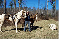 The
vegetation is mostly hardwood forest, with some areas of pine. About
half of the GPT is wooded single-track trail, and the other half is
grassy old dirt roadway. The photo on the right shows one of the linear
grass ways available at the area.
The
vegetation is mostly hardwood forest, with some areas of pine. About
half of the GPT is wooded single-track trail, and the other half is
grassy old dirt roadway. The photo on the right shows one of the linear
grass ways available at the area.
Strawberry
Mountain is located in northwest Georgia about six miles south of Villanow.
Strawberry Mountain straddles the Walker and Chattooga county line.
From Villanow, travel south on the West Armuchee Road (scenic county
highway 705) for about six miles (10 minutes) and turn right on Manning
Mill Road. A red house is on the left before the turn, and a Pinhoti
Trail sign is located at this turn. Go about one mile on Manning Mill
Road, a narrow asphalt road, and then you will see the Pinhoti parking
lot access on the left.
![]()
![]()