622. Route 710 is from Route 1 to Route 210 in Pasadena.
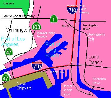
622.1. (a) Route 710 shall also include that portion of the freeway
between Route 1 and the northern end of Harbor Scenic Drive, that
portion of Harbor Scenic Drive to Ocean Boulevard, that portion of
Ocean Boulevard west of its intersection with Harbor Scenic Drive to
its junction with Seaside Boulevard, and that portion of Seaside
Boulevard from the junction with Ocean Boulevard to Route 47.
(b) Subdivision (a) shall not become operative, and this section
shall be repealed on January 1, 1985, unless the commission approves,
not later than December 31, 1984, a financial plan, which is
submitted to them by the Los Angeles County Transportation Commission
not later than January 1, 1984.
(c) The financial plan shall be prepared in cooperation with the
department and shall include, but not be limited to, a cost estimate
and the source of funding to make the route changes in subdivision
(a) and any proposed improvements.
 Here's a map of what they're talking about in Code 622.1.a:
 |
 Entire route.
 Constructed portions:
(a) From Route 1 to one mile north of Route 10 at Valley Bl near
Alhambra.
(b) From California Bl in Pasadena to Route 210 (1 mile long).
The freeway, including the northern stub, is called the Long Beach Fwy.
Constructed portions:
(a) From Route 1 to one mile north of Route 10 at Valley Bl near
Alhambra.
(b) From California Bl in Pasadena to Route 210 (1 mile long).
The freeway, including the northern stub, is called the Long Beach Fwy.
 Signed as an Interstate highway. Unconstructed from Valley Blvd north
to California Bl.
Signed as an Interstate highway. Unconstructed from Valley Blvd north
to California Bl.
 This freeway first came with the number 15. But the adoption of the
Interstates in 1964 took the number to its nowaday position, Route 15. After
1964, it was Route 7. The freeway was submitted for Interstate
adoption and was then renumbered to Route 710 in 1984.
This freeway first came with the number 15. But the adoption of the
Interstates in 1964 took the number to its nowaday position, Route 15. After
1964, it was Route 7. The freeway was submitted for Interstate
adoption and was then renumbered to Route 710 in 1984.
 A seperate downtown exit, which is not part of Route 710, exists as
you approach Long Beach heading southward. It will eventually lead you to
the Marina, the ferry to Catalina Island, and the convention center.
A Metro Blue Line station, the Del Amo Station, with its own Park-and-
Ride lot, is on Del Amo Blvd and then westward in Carson. For more info on
that, go to the Union Station page.
Cal State Los Angeles is on Valley Boulevard, or, if you take the
transition to Route 10 west, on Eastern Avenue. A Metrolink and busway
station is located near the campus.
As you may know already, there's a part of the Long Beach Freeway six
miles long that hasn't been constructed. Local opposition, especially in
South Pasadena, has prevented the construction. Here's an article from the
August 2, 1996, L.A. Times dealing with the misleading signs on Route 710
(and without permission) by George Ramos:
You're an out-of-towner chugging along the Santa Ana Freeway for a game
at the Rose Bowl. The traffic is slowing down when you look up at a sign
that suddenly looks very enticing: 710 North/Pasadena.
Great, a shourcut to Pasadena!
You move over to the 710-the Long Beach Freeway-where the traffic is
pushing 70 mph.
But minutes later, the freeway unceremoniously comes to a halt and you
end up on Valley Boulevard in Alhambra.
Yep, Alhambra, about six miles from Pasadena.
You soon discover what dozens of motorists--both locals and outh-of-
towners--learn every day: Signs promising a 710 route to Pasadena constitute
false advertising.
When the 710 was completed in 1965, the expectation was that it would
eventually be extended all the way to Pasadena.
But that plan has long been on hold--delayed by opposition from
preservationists, those concerned about the ever-rising costs, and residents
along the proposed path through El Sereno, South Pasadena, and Pasadena.
So the 710 stops at Valley Boulevard, just north of Cal State L.A.
Caltrans has not changed many of the large overhead freeway signs
because it hopes that one day the 710 will actually go to Pasadena.
Only a few signs on the 710 north--about a mile from where the freeway
ends--show Valley Boulevard as the final, rather unglamorous destination.
Two smaller signs on the freeway shoulder indicate that if motorists
want to get to Pasadena, they must go east on the Sand Bernardino Freeway
(I-10) to get there.
Following those signs, motorists travel for about six miles to the
promised Pasadena exit at Rosemead Boulevard [[Route 19]]. There, even
though they are on the right track, they're still nine more miles away from
Pasadena. "You should hear the drivers when they ask 'Where's Pasadena?'"
said one employee of a carwash on Rosemead near that freeway exit. "They're
cussing, they're angry."
A Caltrans spokeswoman said the agency is possibley willing to replace
or cover up some of the misleading signs.
"We want to make the commute easier," but officials are not sure that
the answer is to replace all the Pasadena signs, spokeawoman Margie Tiritilli
ssaid. The estimated cost would exceed $700,000.
Back on Valley, the consternation among lost motorists can get intense.
"I get about two to five persons a day asking about how to get to
Pasadena," said mechanic Gary Wong, who works at an Arco gas station on
Valley where the 710 dead-ends. "They want to get to the Rose Bowl or
something like that. They just want to get there, quick."
Down the street, Andy Anderson also sees a lot of lost souls. A
salesman at the Y-Tire Goodyear store, Anderson said, "[The lost motorists]
are a pain in the butt, but what are you going to do?" He helps them get
on their way to Pasadena, but adds in a huff, "They don't buy tires."
Alhambra officials say the 710 dumps thousands of cars onto Valley
and nearby streets, adding more congestion to already busy thoroughfares.
For lost motorists, Anderson offers his own "Pathfinder" directions
to Pasadena"
Head east on Valley to Fremont Avenue, he tells them. That avenue is
named for John C. Fremont, the early California figure whose treks of
exploration earned him the nickname of Pathfinder.
Go north on Fremont for four to five miles. Take a quick left on
Columbia Street at the Pasadena city line. Then a quick right leads the
driver to the promised land--Pasadena Avenue in Pasadena. From there, the
210 and 134 freeways, the Rose Bowl and Old Pasadena are easy to find.
Of course, real Pathfinders know there are easier ways to get to
Pasadena. Like taking the Pasadena Freeway [[Route 110]].
And after many years of waiting, that gap of the freeway will be
constructed. Caltrans has planned a six-lane freeway with two carpool
lanes in the middle. To make the South Pasadenans a bit less angry, the
interchange with Route 110 has been scrapped from the plan. Also, two
"cut-and-cover" tunnels have been planned. For more information of the
route go to this Caltrans link.
California State Highways (Pull-down)
California State Highways (Tables)
The Main Page
A seperate downtown exit, which is not part of Route 710, exists as
you approach Long Beach heading southward. It will eventually lead you to
the Marina, the ferry to Catalina Island, and the convention center.
A Metro Blue Line station, the Del Amo Station, with its own Park-and-
Ride lot, is on Del Amo Blvd and then westward in Carson. For more info on
that, go to the Union Station page.
Cal State Los Angeles is on Valley Boulevard, or, if you take the
transition to Route 10 west, on Eastern Avenue. A Metrolink and busway
station is located near the campus.
As you may know already, there's a part of the Long Beach Freeway six
miles long that hasn't been constructed. Local opposition, especially in
South Pasadena, has prevented the construction. Here's an article from the
August 2, 1996, L.A. Times dealing with the misleading signs on Route 710
(and without permission) by George Ramos:
You're an out-of-towner chugging along the Santa Ana Freeway for a game
at the Rose Bowl. The traffic is slowing down when you look up at a sign
that suddenly looks very enticing: 710 North/Pasadena.
Great, a shourcut to Pasadena!
You move over to the 710-the Long Beach Freeway-where the traffic is
pushing 70 mph.
But minutes later, the freeway unceremoniously comes to a halt and you
end up on Valley Boulevard in Alhambra.
Yep, Alhambra, about six miles from Pasadena.
You soon discover what dozens of motorists--both locals and outh-of-
towners--learn every day: Signs promising a 710 route to Pasadena constitute
false advertising.
When the 710 was completed in 1965, the expectation was that it would
eventually be extended all the way to Pasadena.
But that plan has long been on hold--delayed by opposition from
preservationists, those concerned about the ever-rising costs, and residents
along the proposed path through El Sereno, South Pasadena, and Pasadena.
So the 710 stops at Valley Boulevard, just north of Cal State L.A.
Caltrans has not changed many of the large overhead freeway signs
because it hopes that one day the 710 will actually go to Pasadena.
Only a few signs on the 710 north--about a mile from where the freeway
ends--show Valley Boulevard as the final, rather unglamorous destination.
Two smaller signs on the freeway shoulder indicate that if motorists
want to get to Pasadena, they must go east on the Sand Bernardino Freeway
(I-10) to get there.
Following those signs, motorists travel for about six miles to the
promised Pasadena exit at Rosemead Boulevard [[Route 19]]. There, even
though they are on the right track, they're still nine more miles away from
Pasadena. "You should hear the drivers when they ask 'Where's Pasadena?'"
said one employee of a carwash on Rosemead near that freeway exit. "They're
cussing, they're angry."
A Caltrans spokeswoman said the agency is possibley willing to replace
or cover up some of the misleading signs.
"We want to make the commute easier," but officials are not sure that
the answer is to replace all the Pasadena signs, spokeawoman Margie Tiritilli
ssaid. The estimated cost would exceed $700,000.
Back on Valley, the consternation among lost motorists can get intense.
"I get about two to five persons a day asking about how to get to
Pasadena," said mechanic Gary Wong, who works at an Arco gas station on
Valley where the 710 dead-ends. "They want to get to the Rose Bowl or
something like that. They just want to get there, quick."
Down the street, Andy Anderson also sees a lot of lost souls. A
salesman at the Y-Tire Goodyear store, Anderson said, "[The lost motorists]
are a pain in the butt, but what are you going to do?" He helps them get
on their way to Pasadena, but adds in a huff, "They don't buy tires."
Alhambra officials say the 710 dumps thousands of cars onto Valley
and nearby streets, adding more congestion to already busy thoroughfares.
For lost motorists, Anderson offers his own "Pathfinder" directions
to Pasadena"
Head east on Valley to Fremont Avenue, he tells them. That avenue is
named for John C. Fremont, the early California figure whose treks of
exploration earned him the nickname of Pathfinder.
Go north on Fremont for four to five miles. Take a quick left on
Columbia Street at the Pasadena city line. Then a quick right leads the
driver to the promised land--Pasadena Avenue in Pasadena. From there, the
210 and 134 freeways, the Rose Bowl and Old Pasadena are easy to find.
Of course, real Pathfinders know there are easier ways to get to
Pasadena. Like taking the Pasadena Freeway [[Route 110]].
And after many years of waiting, that gap of the freeway will be
constructed. Caltrans has planned a six-lane freeway with two carpool
lanes in the middle. To make the South Pasadenans a bit less angry, the
interchange with Route 110 has been scrapped from the plan. Also, two
"cut-and-cover" tunnels have been planned. For more information of the
route go to this Caltrans link.
California State Highways (Pull-down)
California State Highways (Tables)
The Main Page