RESEARCH ACTIVITIES
DEVELOPMENT OF PEAK GROUND ACCELERATION MAPS FOR MALAYSIA USING GEOGRAPHICAL INFORMATION SYSTEM (GIS)
This study establishes the peak ground acceleration maps for seismic design purposes by considering the latest seismological data in Kuala Lumpur area and produces the final results in geographical information system (GIS) environment. A GIS-based mapping system is developed for quick and easy assessment of seismic hazards mainly by considering peak bedrock acceleration. It is developed by using the MapInfo GIS software ?1?. In predicting the ground motion, several attenuation relationships have been considered. The deterministic seismic hazard analysis then is fully utilized to represent the seismic risk level at Kuala Lumpur. Peak ground acceleration has been used as the ground motion parameter. Several equations are used to verify the peak bedrock acceleration value according to the seismological data which collected from Malaysian Meteorological Services. It included past earthquake data from 1897 to 2002. According to the study, it shows that Kuala Lumpur is located in zone 7 or equivalent to 0.03g to 0.05g. The GIS-based mapping system are interactive and user friendly map-serving technology. It is capable to simplify the task of an engineers defining the peak acceleration value in Kuala Lumpur area for seismic design purposes.
Keywords: Development, PGA, GIS, Malaysia
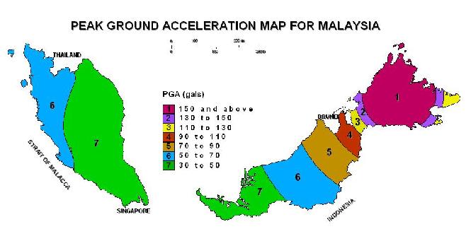

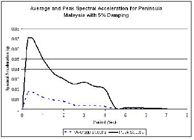
Peak ground Acceleration map and controlling earthquakes for Kuala Lumpur
The 9.0 Richter scale earthquake and followed by destructive tsunami on December 26th last year gave a new experience for Malaysian. There are 67 casualties recorded in West Malaysia, several losses of public belonging and even last with a dramatic situation among the victims. Furthermore, it is forcing the government of Malaysia seriously looking into this situation. Tsunami on December 26th is generated by the massive earthquake occurred in subduction fault near to Banda Acheh, Sumatera. Practically, this is the first time ever experience by Malaysian and recorded as one of the most deadly disasters to this country. Previously, Malaysia is considered safe from earthquake and tsunami. However this tsunami has changed everything and urged for further detail understanding. This paper trying to summarize the scenario, previous effort on earthquake hazard estimation, related research, government effort and also recommend toward better understanding on the disasters. In facts, the early earthquake study in Malaysia was started in 80’s century. The seismological network was developed since 1979 and it is functioned well until today. There are also an efforts made to develop the seismic design code for the country. The early seismic zone map of Malaysia was developed in the year 2002. However, the passive development encountered by the absence of the real disastrous earthquake which significance enough to force any further study. The government has setup the early warning system to monitor the next tsunami. It is to ensure the maximum safety and the number of casualties can be denied if the same disaster occurs. An effort was made at KUiTTHO using the sky as a stepping stone to predict the earthquake before it happened. However it still needs to be verified before it can be considered as a new dimension of earthquake monitoring programme. The newly developed early warning system is very expensive, important and a long term investment by the government. However, it is still not enough without proper education and knowledge deliver to all Malaysians. The engineers need to be educates to make sure they will draw the right professional decisions. The public must be exposed what they will suppose to do when the disaster strike back and what is really happened due to the disasters.
Keywords: Tsunami, experience, challenges, Malaysia

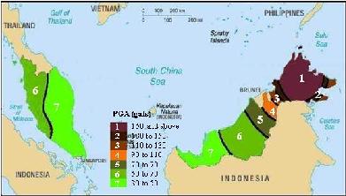
DEVELOPMENT OF PEAK GROUND ACCELERATION MAP AND RESPONSE SPECTRUM USING DETERMINISTIC SEISMIC HAZARD ANALYSIS FOR MALAYSIA
Seismic zonation which includes peak ground acceleration
maps and response spectra of Malaysia has never been done before. This
is due to the Malaysian earthquake event history, which is not so profound.
However, Malaysia is affected by the distance faults around the country.
The nearest seismically active faults around Malaysia are in the Indonesian
and Philippines archipelagos as well as in the east and northeast of Sabah.
A seismic feature of the Indonesian region that will explicitly affected
the Malaysian local seismic hazard evaluations is the Barisan Fault which
runs along the length of Sumatera in a direction parallel to the Java
trench. This fault is a seismically active right-lateral strike-slip fault,
with many shallow focus earthquakes. Several equations were used to evaluate
the possible peak ground acceleration for Malaysia using deterministic
seismic hazard analysis. Such data from earthquake events around Malaysia
was taken from the Malaysia Meteorological Services and other sources.
Classical methods using the Modified Mercalli Intensity Scale and few
other methods were also used to produce the ground acceleration map. Isoseismal
maps of maximum observed intensity for Malaysia (1994) are also taken
into consideration. The results from the analysis were used to produce
an acceleration coefficient map for Malaysia. The acceleration coefficient
map was used in the earthquake design procedure for structures. The design
spectra concepts were used to develop the elastic response spectrum for
single degree of freedom system. The smooth elastic response spectrum
was the best tool for describing the design ground shaking generated by
earthquakes. Finally, the seismic zoning map and the response spectra
produced were used to establish the basic seismic design procedure for
Malaysia.
THE APPLICABILITY OF LASER DOPPLER VIBROMETER
TO
DETERMINE PILE BEARING CAPACITY
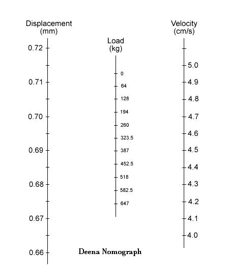
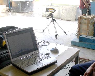
The most reliable method to determine the load capacity of a pile is to load-test the pile (Bowles, 1988). But, these pile load tests are not effective and suitable to fulfill the project need such as to get a good test result to ensure the structure safety without deploying too much cost and time. These pile load tests usually have the same problems such as high operation cost and need a long time to complete. Pile dynamic test is one of the famous and often been used in pile load test. This pile dynamic test is using the pile driving analyzer (PDA) equipment to measure the pile condition, activated bearing capacity, hammer performance, maximum driving stresses and pile or shaft integrity. The PDA uses signals from reusable sensors to collect data. The sensors are fully attached with the pile. In this research, the concept of PDA was applied to a see any possible reasons to utilize the laser technique in a very near future using Laser Doppler Vibrometer (LDV). LDV is an optical instrument for accurately measuring velocity and displacement of vibrating object completely without contact. Regarding to the analysis, it shows that the LDV can be applicable to determine the pile bearing capacity by considering the acceleration, velocity and displacement of waves. As a result, the laser technique seems very applicable and very cost effective to perform the pile load test in the near future.
Keywords: Pile, Laser, Small Scale, Load Test
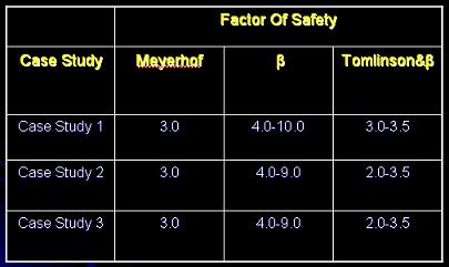
PILE SAFETY FACTOR EVALUATION OF PUBLIC UTILITY BUILDINGS (CASE STUDY: LOW RISE BUILDINGS IN BATU PAHAT)
Most of the buildings in Batu Pahat used pile foundation. Pile foundation
is most popular and commonly used in Batu Pahat since the soil condition
in the area consists from soft soil. Compared with shallow foundation,
pile foundation can ensure better structural safety. To reduce and prevent
foundation failures, pile safety factor are assigned in the pile design.
The purpose of this final year project is to evaluate pile safety factor
on existing public utility buildings in Batu Pahat. This study was focus
on 3 low rise buildings with different height. The assessments of the
pile safety factor were done by re-design the pile foundation using the
same method with actual design which is based on Modified Meyerhof method.
The assessment of the ultimate bearing capacity depends upon the soil
profile. The results obtained shows that the pile safety factor applied
in the design is adequate enough and practical. Then, pile ultimate capacity
by using the different static equation can be determined. Static formulas
used in this study are ß method and combined Tomlinson and ß
method. The pile ultimate bearing capacity from the analysis is compared
with the results of pile allowable capacity from the actual designs to
obtain pile safety factor. Generally, this study shows that the applied
safety factor from the actual design for pile is quite conservative compared
to the others. It is also found that, the pile safety factor based on
ß method is bigger than that. This might be due to more conservatives’
value in the design. Combined Tomlinson and ß method in the design
is under estimated.
Keywords: Safety factor, Allowable bearing capacity, Ultimate bearing capacity
Comparison of Pile Safety Factor by Meyerhof, Tomlinson &
ß Method with Pile Design In Practice Based on Column Design Load
THE LOCAL SITE EFFECT DUE TO AN EARTHQUAKE IN SUMATERA (CASE STUDY: CENTRAL MALACCA, MALACCA)
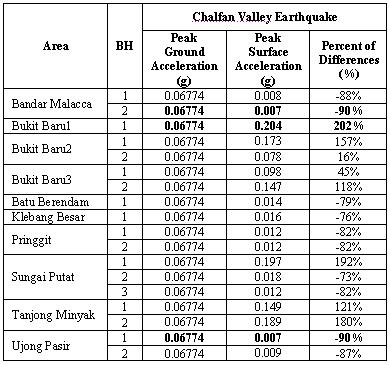
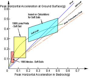
The local site conditions have a great influence to the final vibration of earthquake on a soil surface. The vibration mode can be accelerate, decelerate or similar with the vibration at the bedrock (Samsudin, 2003). Previous experience from 1985 Mexico City Earthquake and 1989 Loma Prieta earthquake show that amplification of ground motion often occurs at sites overlain by thick, soft soil deposits, especially when the predominant period of the earthquake motions matches the predominant period of the ground. The determination of peak surface acceleration is importance for engineers to be considered in dynamic design procedure. It will be able to bring a better understanding of the actual effect of earthquake in Malacca. Central Malacca is chosen as a case study because it is well-known as a tourism state and there are many historical buildings which built long time ago. Regarding to the previous study, the peak bedrock acceleration for Central Malacca is about 0.06g (Nor Azizi, 2002). By the absence of Sumatran earthquake strong motion data, Yerba Earthquake with peak acceleration of 0.06779g and Chalfant Valley Earthquake with peak acceleration of 0.06744g were utilized to represent the ground shaking at Central Malacca. A one dimensional soil modeling using SHAKE2000 was utilized to represent the site response characteristics. There are eighteen boreholes were considered to represent the local site effect. The final result shows that the highest surface acceleration can be up to 0.288g or amplified about 2.36 times compared to the peak bedrock acceleration. The analysis was agreed well with the previous experience in 1989 Loma Prieta earthquake which shows that the amplification on soft site can be up to 2.5 times.
Relationships between Maximum Acceleration on Rock and
Other Local Site Conditions (Idriss, 1990)