
(5) Carry out the following:
(A) Explain what a map is.
(B) Know some of the types of maps that are available, and what information each of these can provide.
There are many different types of map that are available, each having it unique use. Example: Historical Map, which show the place where historical events took place, where old roads were placed, old towns, etc. You also get Topographical Maps which is the map normal used in hiking. We also use weather maps that show the weather patterns and formations. Other common maps include road, town and rural maps.
(C) Demonstrate a knowledge of scale and be able to do conversions between RF(representatative Fraction) scale, graphic scale and statement scale.
RF refers to the scale written as: 1:50 000. This means that for every unit of one on the map it equals 50000 on earth.
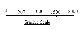
Graphic scale refers to the scale shown by a bar on the map (a pictorial scale).
Statement Scale is as it sounds, a scale that is stated. eg: Its a one in fifty thousand scale.
(D) Demonstrate a knowledge of conventional map symbols.
These symbols can be found on most maps in South Africa or on the South African Scout Association Web page Pro-plan Chart 22 .
(E) Be able to read contours on a map, and explain how contours indicate slopes, gradients and major landforms.

Contours are used to show the difference in elevation on map. The line normal shows a change of 20m, depending on how old the map is. With contours, the closer together they are the steeper the change and vice versa. Everywhere on the contour line is equal to the same height above sea level. This can be seen in Figure 1, which shows the contours of a hill or mountain.
For more information on contours visit the SASA web page Pro - plan 21 chart.
(F) Correctly measure a distance on a map and calculate the actual distance that this represents on the ground.
First, you need to know the route you wish to take, once you have chosen it we can start to work out the distance of the route. We start by finding out the scale of the map, ie 1:50000 etc. Now with the measurement some prefer to use a piece of paper, they place the paper along the route and mark it off on the paper. As they advance they just keep add to the paper until at the end they have a piece of paper with the route, which they measure to the scale. Some use rulers, while I prefer to use a piece of string. The string is able to curve around contours and as the direction changes. What I do is mark the measured distance on the string off to the scale or a ruler and then mark it off on paper. Then continue with the rest of the route and add it up at the end. Remember to take into account the change in contours which adds to the distance of your hike!!!.

(G) Set a map using a compass, and by ground to map comparison.
To set a map using a compass, place the compass on the magnetic north arrow that is located on the side of the map and rotate the map until the needle comes to rest on north. The map is now facing true north and should therefore be set up to the ground features.
To set a map by visible features, you must first know where you are on the map. Then you need to look around for three features that appear on the map. It works best if these objects are spread out. Then align the map to the feature by turn the map until the features are inline with the maps features.
(6) Demonstrate a thorough of all the features on a map by carrying out an imarginary hike of approximately 25km between two points on a map selcted by the examiner. Describe the route in detail and indicate an area which could serve as an overnight stop. Be able to estimate hiking speeds over different terrains indicated on the map by the examiner.
This is where all you have learnt so far comes into play. Before you attempt this requirement, go over all the work. If you need help with this or any of the requirements above, refer to your scouter or fell free to contact the webmaster at [email protected]