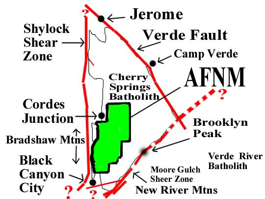
| BASIC GEOLOGY OVERVIEW |
|
Most of the surface rock is Tertiary in age
(Hickey formation) with small amounts of Quaternary sediments at the north end
of the monument. A small part of the north end of the Chalk Canyon formation is exposed at the
south end of the monument where it contacts the Hickey formation.
The last exposure seen going north on I-17, is just past exit 244
and the first exposure seen going south, on the opposite side of I-17,
starts about the middle of mile marker 247.
There are a number of locations along the West side of the monument, near I-17,
where protozoic rocks are exposed. Going north on I-17, the proterozoic rocks start
just north of the Bumble Bee exit-248, along the right side of the road cut.
The Joes Hill, hawaii type, basalt shield volcano (10.8 My) can be seen as a low rounded hill directly
to the east at I-17, Sunset Rest area, at mile marker 252.
At the Northwest end of the monument,
granodorite basement is exposed along with minor amounts of proterozoic mafic lava
flows which may represent a small volcanic center or is an extended part of
the Cordes volcanic center to the West.
Going south on I-17, proterozoic schist is exposed along I-17 around Black Mesa
and at the South end of the monument,
greenstone, altered andesite, migmatite and green schist is the proterozoic basement.
1. A southeast dipping subduction zone created volcanic piles and volcanic centers in a deep ocean environment via island arcs between ~1800 to 1740Ga.
2. The subduction zone flipped direction ~1.745Ga.
3. Arc magmatism changed from volcanism to pluton and batholith formation.
4. The new northwest dipping subduction zone coleased, uplifted, deformed and metamorphosed the Basalt, Andesite and Rhyolite lavas to greenschist grade. These products were rotated the to near vertical and a northeast strike (~9 to 25deg) was imprinted on the whole sequence. Calcic Granodiorite Plutons (Bumblebee & Badger Spring) then invaded the resultant modified volcanic piles around 1.74 to 1.735Ga.
5. These older granite family rocks may have been invaded by the 1.43Ga anorgenic(?) granite plutons that caused more uplift and stabilization of the new crust. None of the anorgenic(?) granites have been found in the AFNM yet.
6. NOTE: For more information, refer to Geology 1982, V10, p37-42, K.C. Condie."Plate-tectonics model for Proterozoic continental accretion in the southwestern US".
Below is a list of general area formations names by increasing age;