|
All VDC Information
All VDC Information
Brief Introduction
Khare VDC
1.
VDC Boundary
|
East :
|
Ramechhap District
|
West :
|
Orang & Bulung VDC
|
|
North :
|
Gaurishankar Vdc
|
South :
|
Chanku & Marbu Vdc
|
2.
Distance From District District Headquarter:
3.
Total Area :
2392 (Ha.)
|
Arable Land :
|
649
|
Other Land :
|
1742
|
4.
Total Household : 379
5.
Total Population : 2384
|
Male :
|
1204
|
Female :
|
1180
|
6.
Average Family Size : 6.3
7.
Major Ethnic Group : Chheteri, Shrpa, Newar, Braman,
Tamang And Thami
8.
Major Religion (In Percentage) :
|
Hindu :
|
55.4
|
Buddha :
|
44.6
|
|
Others :
|
X
|
|
|
9.
Main Occupation : Agriculture
10.
Major Crops : Maize , Millet , Rice ,Wheat 10% And Buck Wheat
11.
Main Livestock : Buffalo, Cow, Goat And Hen
12.
Main Horticulture : Pear
13.
Literacy Rate : 2328
|
Male : 27.19
|
|
Female :
|
19.37
|
14.
No Of School :
|
Primary : 5
|
|
Secondary : 1
|
|
|
Higher Secondary : x
|
|
Campus : x
|
|
15.
Main Rivers : Bhotekoshi, Kharekhola
16.
Sources Of Drinking Water (In Percentage) :
|
Pipe :
|
60.16
|
Others :
|
39.84
|
17.
HH With Toilet : 68
18.
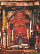
Main Place For Tourism : Natural Beauties, Religious
Spots (Mahadevs Than, Devisthan)
19.
Main Hills And Passage :
20.
Facility Of Transportation :
21.
Communication Facilities :
|
Post Office :
|
1
|
Telephone :
|
X
|
22.
Service Center
23.
Major Wildlife : Leopard, Bear, Deers, Lopophorus,
Pheasant
24.
Major Forest And Forest Product : Pine, Khsru, Chilaune
Brief Introduction Gaurishankar
Vdc
1. VDC
Boundary
|
East :
|
Sulukhambu Dist.
|
West :
|
Lamabagar VDc
|
|
North :
|
China
|
South :
|
Khare VDC & Ramechhap district.
|
2.
Distance From District Headquarter: 51.2 km. (16 Kosh)
3.
Total Area : 4943
(Ha.) (Surveyed Only)
|
Arable Land :
|
4 89
|
Other Land :
|
4454
|
4.
Total Household : 334
5.
Total Population : 1568
6.
Average Family Size : 4.7
7.
Major Ethnic Group : Shrpa, Tamang and Gurung.
8.
Major Religion (In Percentage) :
|
Hindu :
|
16.17
|
Buddha :
|
83.83
|
|
Others :
|
X
|
|
|
9.
Main Occupation : Agriculture/Trekking/Mountaineering
10.
Major Crops : Potato, Maize & Millet
11.
Main Livestock : Sheep, Cow & Yak
12.
Main Horticulture : Plum, Peach.
13.
Literacy Rate : 44.75
|
Male :72.03
|
|
Female :
|
17.47
|
14.
No Of School :
|
Primary : 5
|
|
Secondary : x
|
|
|
Higher Secondary : x
|
|
Campus : x
|
|
15.
Main Rivers : Rolkhola, Dudhakunda, Sipringkhola, Ghattakhola,
Tekukhola
16.
Sources Of Drinking Water (In Percentage) :
|
Pipe :
|
38.62
|
Others :
|
31.38
|
17.
HH With Toilet : 69
18.
Main Place For Tourism : Natural Beauties, Mountain Range,
Traking & Tcho-Rolpa Tal, Religious Spots (Gumba), Beding, Rolwaling
valley.
19.
Main Hills And Passage : Mt. Gaurishankar, Rolbaling, Tannagi.
20.
Facility Of Transportation :
x
21.
Communication Facilities :
|
Post Office :
|
1
|
Telephone :
|
X
|
22.
Service Center
23.
Major Wildlife : Deer, Musk-Deer, Leopard, Beer,
Pheasant.
24.
Major Forest And Forest Product : Pine, Uttis, Chilaune,
Thuja.
Brief
Introduction Chankhu Vdc
1. VDC
Boundary
|
East :
|
Shyma & Marbu VDCs
|
West :
|
Khare & Suri VDCs
|
|
North :
|
Marbu & Hhare VDCs
|
South :
|
Suri VDC
|
2. Distance
From District Headquarter: 41.6 km. (13 Kosh)
3. Total
Area : 1845 (Ha.)
|
Arable Land :
|
461
|
Other Land :
|
1384
|
4. Total
Household : 290
5. Total
Population : 1735
6. Average
Family Size : 6.0
7. Major
Ethnic Group : Shrpa, Gurung, Tamang,
Kami.
8. Major
Religion (In Percentage) :
|
Hindu :
|
23.1
|
Buddha :
|
76.9
|
|
Others :
|
X
|
|
|
9. Main
Occupation : Agriculture
10. Major Crops :
Maize, Millet, Wheat, Potato & Barley.
11. Main Livestock
:Yak, Sheep & Goat
12. Main Horticulture
: Pear, Plum, Gova & Banana.
13. Literacy Rate :
42.21
|
Male : 69.91
|
|
Female :
|
14.57
|
14. No Of School :
|
Primary : 4
|
|
Secondary : x
|
|
|
Higher Secondary : x
|
|
Campus : x
|
|
15. Main Rivers : Suri
Khola & Kharekhola.
16. Sources Of
Drinking Water (In Percentage) :
17. HH With Toilet :
55
18. Main Place For
Tourism : Natural Beauties, Religious Spots (Gumba, Bhume Temple).
19. Main Hills And
Passage :
20. Facility Of
Transportation : x
21. Communication
Facilities :
|
Post Office :
|
1
|
Telephone :
|
X
|
22. Service Center
23. Major Wildlife :
Leopard, Bear, Musk-Deer, Pheasant, Partridge.
24. Major Forest And
Forest Product : Pine, Chanp, Dhuja, Uttis, Chilaune.
Brief
Introduction Marbu VDC
1. VDC
Boundary
|
East :
|
Ramechhap District
|
West :
|
Chnkhu & Khare VDCs
|
|
North :
|
Kare & GaurishankarVDCs
|
South :
|
Chnkhu & Shyama VDCs
|
2. Distance
From District Headquarter: 44.8 km. (14 Kosh)
3. Total
Area : 2867 (Ha.)
|
Arable Land :
|
613
|
Other Land :
|
2254
|
4. Total
Household : 300
5. Total
Population : 1570
6. Average
Family Size : 5.2
7. Major
Ethnic Group : Shrpa, Gurung, Magar,
Tamang, Chheteri, Kami.
8. Major
Religion (In Percentage) :
|
Hindu :
|
61
|
Buddha :
|
39
|
|
Others :
|
X
|
|
|
9. Main
Occupation : Agriculture
10. Major Crops :
Maize, Potato, Millet & Buckwheat.
11. Main Livestock :
Sheep, Cow & Buffalo. Yak
12. Main Horticulture
: Plum, Peach.
13. Literacy Rate :
1847
|
Male : 25.31
|
|
Female :
|
11.63
|
14. No Of School :
|
Primary : x
|
|
Secondary : x
|
|
|
Higher Secondary :
|
|
Campus : x
|
|
15. Main Rivers :
Hupchikhola, Kharekhola, Sikapaswarkhola.
16. Sources Of
Drinking Water (In Percentage) :
|
Pipe :
|
94.33
|
Others :
|
5.67
|
17. HH With Toilet : 9
18. Main Place For
Tourism : Natural Beauties, Religious Spots (Gumba, Mahadev Temple, Himalayan
Rang).
19. Main Hills And
Passage : Patibhara, Hupchi.
20. Facility Of
Transportation :
21. Communication
Facilities : x
|
Post Office :
|
1
|
Telephone :
|
X
|
22. Service Center
23. Major Wildlife :
Deer (Mirga, Tharal, Ghoral), Musk-Deer, Leopard, Beer, Pheasant.
24. Major Forest And
Forest Product : Pine, Uttis, Chilaune, Thuja, Khasru.
Brief
Introduction Suri Vdc
1. VDC
Boundary
|
East :
|
Shyama VDCs
|
West :
|
Laduk VDC
|
|
North :
|
Khare & Chankhu VDCs
|
South :
|
Jhyanku VDC
|
2. Distance
From District Headquarter: 38.4 km. (12 Kosh)
3. Total
Area : 2732 (Ha.)
|
Arable Land :
|
958
|
Other Land :
|
1774
|
4. Total
Household : 731
5. Total
Population : 3838
|
Male :
|
1932
|
Female :
|
1906
|
6. Average
Family Size : 5.3
7. Major
Ethnic Group : Chheteri, Tamang, Shrpa,
Kami Brahman, Newar, Gurung, Surel.
8. Major
Religion (In Percentage) :
|
Hindu :
|
70.73
|
Buddha :
|
29.27
|
|
Others :
|
X
|
|
|
9. Main
Occupation : Agriculture
10. Major Crops :
Maize, Paddy, Wheat, Millet & Buckwheat.
11. Main Livestock :
Cow, Buffalo, Ship, Goat & Yak.
12. Main Horticulture
: Orange, Pear, Guava, Peach & Lime.
13. Literacy Rate :
41.09
|
Male : 56.07
|
|
Female :
|
26.11
|
14. No Of School :
|
Primary : 1
|
|
Secondary : 1
|
|
|
Higher Secondary : x
|
|
Campus : x
|
|
15. Main Rivers :
Bhotekoshi, Tinekhu Khola.
16. Sources Of
Drinking Water (In Percentage) :
17. HH With Toilet :
520
18. Main Place For
Tourism : Natural Beauties, Religious Spots (Tinekhu Mahadev, Devisthan),
Gurumphi Mela.
19. Main Hills And
Passage : Cherdung, Pathibhara, Homchi.
20. Facility Of
Transportation : 2 Hours food from
Singati.
21. Communication
Facilities :
|
Post Office :
|
1
|
Telephone :
|
X
|
22. Service Center
|
Health Post :
|
1
|
Livestock :
|
1
|
|
Agriculture :
|
1
|
|
|
23. Major Wildlife :
Leopard, Beer, Deer, Lopophorus & Pheasant.
24. Major Forest And
Forest Product : Pine, Uttis, Chilaune, Wallnot & Khasru.
Brief
Introduction Kabre Vdc
1. VDC
Boundary
|
East :
|
Jiri VDC
|
West :
|
Namdu VDC
|
|
North :
|
Chhetrapa VDC
|
South :
|
Mirge VDC
|
2. Distance
From District Headquarter: 19.2 km. (6 Kosh)
3. Total
Area : 1634 (Ha.)
|
Arable Land :
|
1116
|
Other Land :
|
518
|
4. Total
Household : 1080
5. Total
Population : 5439
|
Male :
|
2748
|
Female :
|
2691
|
6. Average
Family Size : 5
7. Major
Ethnic Group : Brahman, Chheteri,
Damai, Sarki,
8. Major
Religion (In Percentage) :
|
Hindu :
|
97.5
|
Buddha :
|
2.5
|
|
Others :
|
X
|
|
|
9. Main
Occupation : Agriculture
10. Major Crops :
Paddy, Wheat, Millet & Maize.
11. Main Livestock :
Cow, Buffalo, Ship, & Pig.
12. Main Horticulture
: Lime, Lemon, Plum, Orange.
13. Literacy Rate :
61.64
|
Male :
|
74.05
|
Female :
|
49.23
|
14. No Of School :
|
Primary :
|
6
|
Secondary :
|
1
|
|
Higher Secondary :
|
1
|
Campus :
|
1
|
15. Main Rivers :
Ghattekhola, Khahareklhola
16. Sources Of
Drinking Water (In Percentage) :
17. HH With Toilet :
317
18. Main Place For
Tourism : Natural Beauties
19. Main Hills And
Passage : Hanumante
20. Facility Of
Transportation : Highway
21. Communication
Facilities :
|
Post Office :
|
1
|
Telephone Line :
|
4
|
22. Service Center
|
Health Post
|
1
|
Transport :
|
1
|
|
|
|
|
|
23. Major Wildlife :
Leopard, Monkey, Deer, Rabbit, Parrot, Dove, Sarau.
24. Major Forest And
Forest Product : Pine, Uttis & Chilaune.
Brief
Introduction Jungu Vdc
1. VDC
Boundary
|
East :
|
Jiri & Mali
VDCs
|
West :
|
Sunkhani VDC
|
|
North :
|
Jhyanku VDc
|
South :
|
Chhetrapa VDC
|
2. Distance
From District Headquarter: 28.8 km. (9
Kosh)
3. Total
Area : 3179 (Ha.)
|
Arable Land :
|
1170
|
Other Land :
|
2009
|
4. Total
Household : 902
5. Total
Population : 4378
|
Male :
|
2266
|
Female :
|
2112
|
6. Average
Family Size : 4.9
7. Major
Ethnic Group : Chheteri, Jirel, Tamang,
Brahman & Magar.
8. Major
Religion (In Percentage) :
|
Hindu :
|
84.15
|
Buddha :
|
1585
|
|
Others :
|
X
|
|
|
9. Main
Occupation : Agriculture
10. Major Crops :
Paddy, Millet & Maize.
11. Main Livestock :
Cow, Buffalo, Goat & Ship.
12. Main Horticulture
: Lemon, Pear , Peach, Orange, Walnut.
13. Literacy Rate :
41.49
|
Male :
|
52.44
|
Female :
|
30.54
|
14. No Of School :
|
Primary :
|
7
|
Secondary :
|
1
|
|
Higher Secondary :
|
x
|
Campus :
|
x
|
15. Main Rivers :
Junjukhola.
16. Sources Of
Drinking Water (In Percentage) :
|
Pipe :
|
77.38
|
Others :
|
22.62
|
17. HH With Toilet :
179
18. Main Place For
Tourism : Natural Beauties, Religious Sport (Devisthan)
19. Main Hills And
Passage :
20. Facility Of
Transportation : x
21. Communication
Facilities :
|
Post Office :
|
1
|
Telephone Line
:
|
X
|
22. Service Center
|
Sub-health Post
|
1
|
Agriculture :
|
1
|
|
|
|
|
|
23. Major Wildlife :
Tiger, Beer, Deer, Rabbit & Monkey.
24. Major Forest And
Forest Product : Pine, Sal, Rhododendron, Phalat, Uttis & Chilaune.
Brief
Introduction Jhyanku Vdc
1. VDC
Boundary
|
East :
|
Suri & Mali VDCs
|
West :
|
Lamidanda VDC
|
|
North :
|
Laduk & Suri VDCs
|
South :
|
Junju VDC
|
2. Distance
From district district Headquarter 35.1
km. (11 Kosh)
3. Total
Area : 3134 (Ha.)
|
Arable Land :
|
1418
|
Other Land :
|
1716
|
4. Total
Household : 946
5. Total
Population : 5081
|
Male :
|
2659
|
Female :
|
2422
|
6. Average
Family Size : 5.4
7. Major
Ethnic Group : Chheteri, Sherpa, Jirel,
Tamang, Kami & Dami.
8. Major
Religion (In Percentage) :
|
Hindu :
|
58.46
|
Buddha :
|
41.54
|
|
Others :
|
X
|
|
|
9. Main
Occupation : Agriculture
10. Major Crops :
Paddy, Millet & Maize.
11. Main Livestock :
Cow, Buffalo & Goat.
12. Main Horticulture
: Guava, Banana, Mango, Lime, Pear & Plum.
13. Literacy Rate : 38.45
|
Male :
|
55.98
|
Female :
|
20.92
|
14. No Of School :
|
Primary :
|
9
|
Secondary :
|
1
|
|
Higher Secondary :
|
x
|
Campus :
|
x
|
15. Main Rivers :
Jhyankukhola, Tinekhukhola
16. Sources Of
Drinking Water (In Percentage) :
|
Pipe :
|
80.55
|
Others :
|
19.45
|
17. HH With Toilet :
447
18. Main Place For
Tourism : Natural Beauties, Religious Sport (Airmagumba, jhyankugumba,
devisthan)
19. Main Hills And
Passage : Chardung
20. Facility Of
Transportation :
21. Communication
Facilities :
|
Area Post Office :
|
1
|
Telephone :
|
X
|
22. Service Center
23. Major Wildlife :
Tiger, Beer, Leopard, Deer & Lopophorus.
24. Major Forest And
Forest Product : Pine, Thuja, Khasru, Uttis & Chilaune.
Brief
Introduction Namdu Vdc
1. VDC
Boundary
|
East :
|
Kabre VDC
|
West :
|
Bhimeshwor municipality
|
|
North :
|
Bhimeshor municipality & Chatrapa VDC
|
South :
|
Gairimudi & Mirge VDCs
|
2. Distance
From district district Headquarter : 16
km. (5 Kosh)
3. Total
Area : 1837 (Ha.)
|
Arable Land :
|
1125
|
Other Land :
|
712
|
4. Total
Household : 1087
5. Total
Population : 6218
|
Male :
|
3051
|
Female :
|
3167
|
6. Average
Family Size : 5.7
7. Major
Ethnic Group : Brahwan, Chheteri,
Tamang, Newar, Damai, Kami, Sharki.
8. Major
Religion (In Percentage) :
|
Hindu :
|
89.33
|
Buddha :
|
10.67
|
|
Others :
|
X
|
|
|
9. Main
Occupation : Agriculture
10. Major Crops :
Paddy, Millet, Wheat & Maize.
11. Main Livestock :
Cow, Buffalo, Pig, Sheep & Goat.
12. Main Horticulture
: Orange, Peach, Lime, Pear & Plum.
13. Literacy Rate :
41.49
|
Male :
|
44.32
|
Female :
|
39.46
|
14. No Of School :
|
Primary :
|
9
|
Secondary :
|
1
|
|
Higher Secondary :
|
x
|
Campus :
|
x
|
15. Main Rivers :
Tamakoshi, Baitikhola, Kharekhola, Satikhola, Bhaterekhola.
16. Sources Of
Drinking Water (In Percentage) :
|
Pipe :
|
83.9
|
Others :
|
16.1
|
17. HH With Toilet :
532
18. Main Place For
Tourism : Natural Beauties.
19. Main Hills And
Passage :
20. Facility Of
Transportation :
21. Communication
Facilities :
|
Post Office :
|
1
|
Telephone :
|
X
|
22. Service Center
23. Major Wildlife :
Tiger, Beer, Rabbit, Dove & Partridge.
24. Major Forest And
Forest Product : Pine, Sal & Uttis.
Brief
Introduction Chhetrapa Vdc
1. VDC
Boundary
|
East :
|
Kabre & Jiri VDCs
|
West :
|
Sunkhani VDC
|
|
North :
|
Junju VDC
|
South :
|
Namdu & Kabre VDCs
|
2. Distance
From district district Headquarter : 16
km. (5 Kosh)
3. Total
Area : 1271 (Ha.)
|
Arable Land :
|
600
|
Other Land :
|
671
|
4. Total
Household : 498
5. Total
Population : 2756
|
Male :
|
1353
|
Female :
|
1403
|
6. Average
Family Size : 5.5
7. Major
Ethnic Group : Chheteri, Newar,
Sharki.
8. Major
Religion (In Percentage) :
|
Hindu :
|
77.31
|
Buddha :
|
22.69
|
|
Others :
|
X
|
|
|
9. Main
Occupation : Agriculture
10. Major Crops : Paddy,
Millet, Wheat & Maize.
11. Main Livestock :
Cow, Buffalo & Goat.
12. Main Horticulture
: Orang, Lemon, Lime, Peach & Plum.
13. Literacy Rate :
40.05
|
Male :
|
51.17
|
Female :
|
28.93
|
14. No Of School :
|
Primary :
|
4
|
Secondary :
|
1
|
|
Higher Secondary :
|
x
|
Campus :
|
x
|
15. Main Rivers :
Tamakoshi, Puktikhola, Adharikhola.
16. Sources Of
Drinking Water (In Percentage) :
|
Pipe :
|
73.7
|
Others :
|
26.3
|
17. HH With Toilet :
88
18.
Main Place For Tourism : Natural Beauties Religious Sports
(Chhetrawatimahadev).
19. Main Hills And
Passage : Hanumente, Deurali.
20. Facility Of
Transportation :
21. Communication
Facilities :
|
Post Office :
|
1
|
Telephone :
|
X
|
22. Service Center
23. Major Wildlife :
Tiger, Beer, Dear & Pheasant.
24. Major Forest And
Forest Product : Pine, Uttis, Chilaune & Sal.
copyright © DolakhaNepal 2004
|