The Great Nile River
The
River
The Nile river is
the longest river in the world. It's 4,132 miles in length and
1,107,000 sqare-mile basin. The Nile river is made up of two
rivers the White Nile and the Blue Nile. These rivers meet in
Sudan and then go on on their large journey. The white Nile is a
lot bigger then the Blue Nile..
 There is no better way to trace the course of
Egyptian history than to follow the course of the Nile. The river
has been Egypt's lifeline for millenniums, fertilizing the narrow
strip of land along its bank with a deposit of silt after each
annual inundation - now controlled by the High Dam at Aswan.
Along its length Pharaohs, nobles and lesser mortals have all
built monuments and tombs to immortalize themselves.
There is no better way to trace the course of
Egyptian history than to follow the course of the Nile. The river
has been Egypt's lifeline for millenniums, fertilizing the narrow
strip of land along its bank with a deposit of silt after each
annual inundation - now controlled by the High Dam at Aswan.
Along its length Pharaohs, nobles and lesser mortals have all
built monuments and tombs to immortalize themselves.
The
Nile is Associated with Life
"Egypt is the
gift of the River Nile", said Herodotus, the great Greek
historian, on his only visit to Egypt. Egyptians would still
agree wholeheartedly with his words today. At the end of every
year, they are eager to hear good news about the water level in
the River Nile. In 1994 the volume of inlet water was considered
high. In the High Dam Lake, water reached its highest ever level.
Since
time immemorial, Egyptians have associated the River Nile with
life, fertility and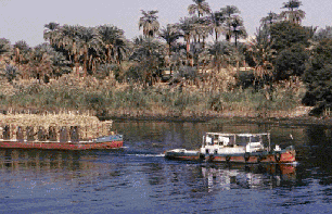 development. They care about it, and it, in
turn, runs in their blood. It has always been their source of
prosperity, and was the main factor in building their great
civilization. It is from the River Nile that Egyptians draw their
friendly character. They have gained generosity, sincerity and
fidelity from its flow, flood and purity. Every day, its banks
witness thousands of true love stories, as lovers meet on its
banks. It provides them with hope and promises them happiness. It
had always been a source of inspiration and creativity for all
kinds of arts. Many songs are dedicated to the River Nile. And in
ancient times, Egyptians made sacrifices for its sake and
transmitted its legends through successive generations.
development. They care about it, and it, in
turn, runs in their blood. It has always been their source of
prosperity, and was the main factor in building their great
civilization. It is from the River Nile that Egyptians draw their
friendly character. They have gained generosity, sincerity and
fidelity from its flow, flood and purity. Every day, its banks
witness thousands of true love stories, as lovers meet on its
banks. It provides them with hope and promises them happiness. It
had always been a source of inspiration and creativity for all
kinds of arts. Many songs are dedicated to the River Nile. And in
ancient times, Egyptians made sacrifices for its sake and
transmitted its legends through successive generations.
History Tells
 Egyptians are blessed with the River Nile,
and they appreciate that. They have always built dams, barrages
and gauges to maintain it. Akhenaton thanked his god for it in
lengthy prayers. Amenamhat III built EI-Lahoon dam in Fayoum city
to manage the irrigation system. Another dam was then constructed
at Madris Lake, topped by a 100km bridge.
Egyptians are blessed with the River Nile,
and they appreciate that. They have always built dams, barrages
and gauges to maintain it. Akhenaton thanked his god for it in
lengthy prayers. Amenamhat III built EI-Lahoon dam in Fayoum city
to manage the irrigation system. Another dam was then constructed
at Madris Lake, topped by a 100km bridge.
Alexander the Great
then extended both Alexandria and Cisostris canals. The latter
joins the River Nile and the Red Sea, and was later rebuilt by
Amr Ibn El-As. In 1861, Mohammed Ali constructed barrages to
substitute the basin irrigation system with a year-round system.
Several waterways, such as El-Mahmoudia, El-Ibrahimia and
El-Ismailia, were then dug.
In 1901 a new dam
was built in Aswan, which was then elevated many times later
until finally, Egyptians built the High Dam in Aswan.
The
High Dam
The High Dam was
seen to symbolize the iron will and great steadfastness of the
Egyptian people.
It protected them
against the annual River Nile inundation, saved the excess water
to be used later at different times, and thereby spared them the
sufferings of drought. The High Dam is the most important project
that Egyptians have implemented for Nile water management. In
fact, it is a landmark in their history. This eminent dam
reflects positively on various areas such as irrigation,
agriculture and power generation. Hundreds of feddans are now
continuously irrigated instead of using the basin system, and
more than a million feddans are now reclaimed. Moreover,
electrical power is generated on daily basis.
Lake
Nasser
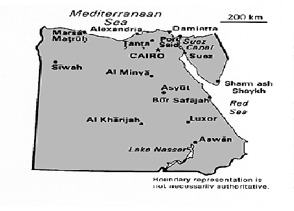
Lake Nasser is a
man-made lake created by the construction of the Aswan High Dam,
opened in 1971. The dam was built to regulate the flow of the
Nile River. The lake it formed stretches over the distance of 312
miles. 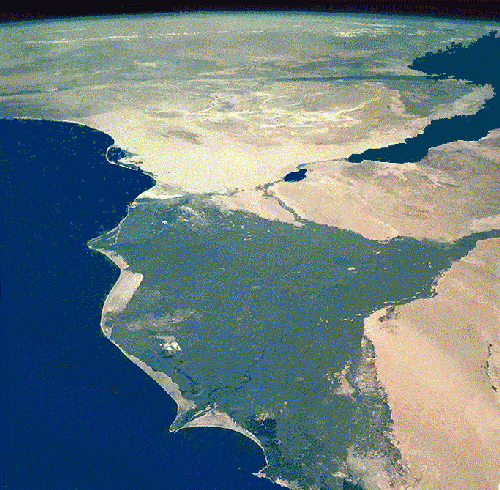
The shoreline covers an overall distance of 4,875 miles. Gone
were the days when the Egyptians would worry that the Nile would
flood too high, destroying their crops, or too low, not providing
the proper irrigation resulting in crop failure.
The water surface of the lake has reduced the average temperature
in the region! The dam has also harnessed the water for the
production of electricity and navigation has been improved.
Technology often introduces unforeseen problems that can disrupt
of human life and nature. The eco-system has been disrupted in
the region.
Farmers are forced to use chemical fertilizers because the rich
top soil is now deposited in Lake Nasser. The Nile is no longer
flowing strong enough to keep salt water from the Mediterranean
Sea from forcing its way up the Nile, disrupting the animal
habitat and sterilizing the soil in the northern delta region
where the banks of the Nile are becoming badly eroded.
Thousands of people, called Nubians, lost their homes when Lake
Nasser was made and ancient sites were either moved or
permanently covered and destroyed by the water.
 Long and Wide
The River Nile's
downstream surface is 2.9km2. It is considered the longest river
in the world, as it flows for 6690km, starting from Tanganicka
Lake to the Mediterranean Sea. On its journey it passes through
nine different countries; namely Tanzania, Kenya, Zaire, Burundi,
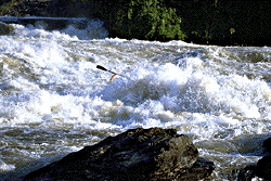
Rwanda, Ethiopia, Uganda, the Sudan and Egypt. Along its way it
encounters many rocky waterfalls, makes sudden deep drops, then
flows along rapidly up and down to reach Egypt's land quietly and
safely.
If you
ever visit Egypt and drink water from the Nile even once, you
will be sure to come back. Indeed Egyptians, as well as all their
guests, believe in that.
The Longest River In The World
From Lake Victoria in east central Africa, The Nile flows
generally north through Uganda, Sudan, and Egypt to the
Mediterranean Sea, for a distance of 5584 km. From its remotest
head stream, the Luvironza River in Burundi, the river is 6671 km
long.
The river basin has an area of more than 2,590,000 km. The source
of the Nile is one of the upper branches of the Kagera River in
Tanzania. The Kagera follows the boundary of Rwanda northward,
turns along the boundary of Uganda, and drains into Lake
Victoria.
On leaving Lake
Victoria the Nile rushes for 483 km between high rocky walls and
over rapids and cataracts until it enters Lake Albert. The
section between the two lakes is called the Victoria Nile. The
river leaves the northern end of Lake Albert as the Albert Nile,
flows through northern Uganda, and at the Sudan border becomes
the Bahr al-Jabal. At its junction with the Bahr al-Ghazal, the
river becomes the Bahr al-Abyad, or the White Nile.
At Khartum the
White Nile is joined by the Blue Nile, or Bahr al-Azraq. The Blue
Nile, 1529 km long, gathers its volume mainly from Lake T'ana, in
the Ethiopian Highlands. From Khartum the Nile flows northeast;
322 km below that city, it is joined by the Atabarah (Atbara)
River. The black sediment brought down by this river settles in
the Nile delta and makes it very fertile. Below Khartum
navigation is rendered dangerous by cataracts, the first
occurring north of Khartum and the sixth near Aswân.
The Nile enters the
Mediterranean Sea by a delta that separates into the Rosetta and
Damietta distributaries. The first dam on the Nile, the Aswân
Dam, was built in 1902 and heightened in 1936. The Aswan High Dam
was dedicated in 1971; it impounds one of the world's largest
reservoirs, Lake Nasser.
Discovery of the Nile
Egypt was blessed
by the Nile in many different ways. Because of the Nile Egypt
became one of the great cradles of world civilation. The Nile
provided the people that moved to it's valley in the year 5000
b.c. water to drink, irrigation water, farming oppertunity, fish
and waterfowl for food, papyrus reeds grew on the banks of the
Nile and they were used for boats and for houses. these reeds
also allowed the ancient Egyptians to make paper on which to
write important documents. The Nile River was gaurded by desert
on either side of it and that offered protection. In ancient
egypt the nile would flood yearly covering up the 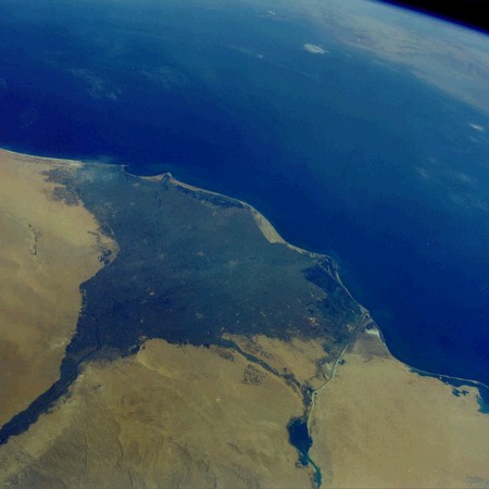 farmlands. This would make
the land very fertile for farming, thus improving Egypts
agriculture. But the aswan high dam stopped the grat river from
flooding each year.
farmlands. This would make
the land very fertile for farming, thus improving Egypts
agriculture. But the aswan high dam stopped the grat river from
flooding each year.
Equator
The equator is an
imaginary circle on the surface of the earth, equidistant from
the north pole and the south pole, and dividing the earth in
half. The Nile has to cross the Equator in order to continue its
long journey. Marine Officer James Corbett says on the Equator
there are chunks of vegetation that breaks loose from the shore.
This makes it very wavy and hard to steer. Some boatsÕ engines
give out and people are stranded in the middle of the Equator.
All year thunderstorms crash and it rains and pours. The Nile is
not the prettiest river when people are crossing it.
History of the Nile
The first few
settlers of the Nile River built houses of papyrus reeds that
were all tied together in columns, with thatched roofs. The walls
were made of straw, mud, and clay. Later settlers used the clay
to build bricks. With the bricks they built stronger houses.
Small villages started to appear along the Nile River. The people
of these villages learned to irrigate and divert the water during
the flooding season. As time passed the residents of the Nile
River became better farmers.
The Land Around The Nile
The land on and
next to the Nile has growing plants as do the oases, but other
wise the land is all dry deserts. The land gets no water there
for they can not grow much. But where the little water is they
grow trees and plants and there most populaur tings dates. The
dates provided food and shade.
Water Use of the Nile
The Nile river's
mingled waters are poured into the Mediterranean. Many Cities get
their water suply from the Nile such as Burundi, Rwandi, Republic
of Congo, Kenya, Uganda, and Ethiopia. One 8th of the Niles water
is supplied by Atbara.
Weather
Most of the weather
around the Nile river is hot and very dry. They hardly get any
rain. Instead of having rain or snow storms they have sand
storms. Sand storms are when the strong winds blow the sand
around and force it into sand hills which are hill made of sand.
These sand storms are not a good thing to be stuck in because
when the sand is being throwen around it feels like sand paper on
your skin.

Egypt
There rose a leader
int the year 3100b.c. He came from Upper Egypt. His name was
Menes. He started a dynasty that would rule for about 3000 years.
Menes organized and had extensive irrigation ditches built to
provide more land for cultivation. One of the achievements that
he made was that he built a temple inside of his capital called
Ptah. The other achievement that he accomplished was a tomb for
himself. He would set the pace for all of his successors. Menes
was known as a god to the residents of the Nile River and to
people today.
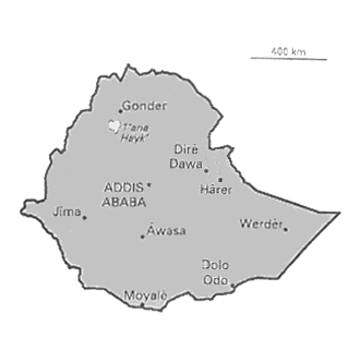
Ethiopia
The population of
Ethiopia is about 51,000,000. It is located in northeast Africa.
It is also formely known as Abyssinia. It is bordered by Eritrea,
Djibouti, Somalia, Kenya and Sudan. Addis Ababa is the capitol.
Ethiopias largest lake is named Lake Tana. In Ethiopia the main
export is coffee with 60% of all exports. The other leading
exports are oilseeds, hides skins, and grain. Amharic is the
official language of ethiopia.
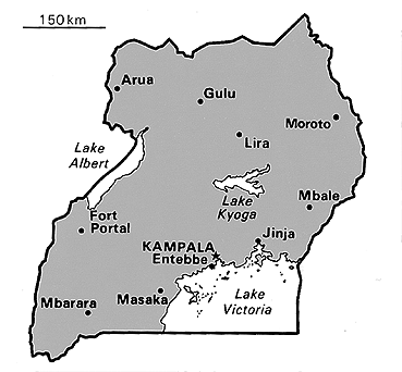
Uganda
The population in
Ugnada is estimated to be 19,386,000. It is located in East
Central Africa and it is bordered by Tanzania, Rwanda, Zaire,
Sudan, and Kenya. The capital of Uganda is Kampala. Uganda is
located across the equater. Lake Kyoga is located in the center
of the country. The highest point in Uganda is Margherita Peak
with an elevation of 16,794 ft. The main type of economy is
agriculture. They farm these types of crops-cassava, sweet
potatoes, plantains, millet, and sorghum, the big producer crop
is coffee with 90% of all of the cash crops. The other cash crops
are cotton, tea, and tobacco.
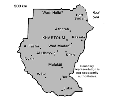
Sudan
Sudan is the
largest country on the african continent. One major topographical
fature of Sudan is the Nile river. The White Nile goes into the
country through the Uganda border and meets the Blue nile at a
point near Khartum, and forms the Nile proper. the Blue nile
rises in the Ethiopian plateau , and flows across east central
Sudan.
Nile Crocodile
Some crocodiles
live on the banks of the Nile river. They are called the Nile
Crocodile. As the male reptiles, with four disict heart chambers,
are catching their pray with a little help from their strong tail
the female is at home laying eggs. The female crocodiles starts
being eligible to lay eggs around the age of 10 years old. She
lays 20 to 90 eggs depending on how old she is. These crocodiles
lay their eggs along the sandy banks of the Nile river where the
sit on the eggs till a baby crocodile is hatched. The Nile is a
big part of a crocodiles life. These animals are blamed for the
deaths of a number of people each year.
Nile Lakes
From the
end of the Ice Age about 11,600 years ago until about 6,000 years
ago, the Nile River Valley was a good place to live where the
people of the Ice Age Civilization could continue their high
culture without much disruption, in marked contrast to the
situation in China where the end of the Ice Age brought great
turbulence. Here are some details about the post-Ice Age Nile
River Valley:
At 11,600 years ago, about when the Vela X
supernova was seen in Earth, a very sudden (50 years or so)
warming event
ended the Ice Age and marked the start of the HOLOCENE AGE of
warm climate and glacial retreat.
As the glaciers melted, lakes filled the Nile River Valley. From
11,600 years ago to 9,000 years ago, the lakes wre filling up.
From 9,000 years ago to 6,000 years ago, the lakes were full, and
the Nile River Valley was rainy, with over 30 cm per year net
precipitation over evaporation loss.
From 6,000 years ago to 4,500 years ago, the lakes dried
out, leaving few with high levels, some medium, but most low, and
the net precipitation declined.
From 4,500 years
ago to now, the Nile River Valley had few lakes and a dry
climate.
As Schwaller de Lubicz, West, Schoch, Bauval, and Hancock have
noted, the Sphinx shows clear geological signs of rain-water
weathering, so the Sphinx must have been built before the end of
the rainy weather in the Nile River Valley.
The Sphinx and the Giza Pyramids were probably all built
together, either by the Ice Age Civilization of 36,525 to 11,600
years ago, or later, but no later than 6,000 years ago.
The 11,600 to 6,000 year old civilization occured after the
sudden warming event ended the Ice Age 11,600 years ago.
There was a continual benevolent Nile River Valley climate until
the rains stopped and the lakes dried up 6,000 years ago.
The period from 6,000 to 4,500 years ago must have put great
stress on the Sphinx-Giza Civilization,
as it was losing its lakes and rains.
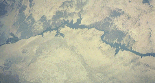
To see what happened, look at the geography of the Nile River
Valley.
The map shows
elevation of the region from the headwaters area of the Nile
River around the Abyssinian Highlands to the mouth of the Nile
River at the Mediterranean Sea in the North.
The Red Sea is on the East.
The lowest levels are the dark green, under 656 feet, roughly the
elevation of the top of the two large Giza Pyramids.
The lowest lands are mostly North of the Safsaf Oasis, marked x
labelled SafSaf.
It is about 200 miles West of the current bed of the Nile River.
The Nile flows north about 200 miles to the East.
The small channels probably formed during relatively wet climatic
periods.
The image clearly shows that in wetter times, the valley would
have supported game animals and vegetation.
Today, as a result of climate change, the area is uninhabited and
lacks water except for a few scattered oases.
You can see that during rainy times, such as the time of the
civilization of 11,600 to 6,000 years ago, a broad region
(roughly light green + dark green) was probably covered by a
network of lakes and rivers.
Most of the real-estate development of the Sphinx-Giza
Civilization would probably have been along the banks of those
old lakes and rivers, now buried by sand and only visible by
radar.
The Nile
A Way of Life
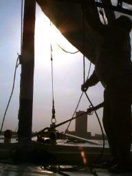
Most
of the people they take on falucca rides are tourists from other
countries, but some of their customers are Egyptians who just
want to spend some leisure time on the Nile. The Nile is a quiet,
slow, river which makes most of their trips nice and leisurely.
Some of Mohammed's and Kamel's jobs on the boat may look like
fun, but most of them are certainly not leisurely. On a busy day
they may take out five or six different groups on long trips. At
times, they've sailed 24 km (about 15 miles) away from their port
-- which is a long way on a boat that is under the mercy of the
wind and the waves. There is no motor on their boat!
The
Nile may be a slow-moving river but the occasional storms are by
no means mild. Kamel says that he would have to be out of his
mind to take out his boat in some of the storms that they have,
but they have never been caught out in the river in one of the
bad ones. There are certain warning signs that let an experienced
sailor know when bad weather is coming. Kamel said that he always
looks to see if the weather is coming from the east, in which
case it might be bad.
 Egypt has
often been called "The Gift of the Nile." This is
because the Nile River has many beneficial qualities that have
helped Egypt throughout the centuries. One of these qualities is
that the Nile flows south to north, but the winds tend to blow
north to south. This way a boatman can float to go in one
direction or sail to go in the other. Either way, boat
transportation is not very difficult and does not require heavy
rowing or towing.
Egypt has
often been called "The Gift of the Nile." This is
because the Nile River has many beneficial qualities that have
helped Egypt throughout the centuries. One of these qualities is
that the Nile flows south to north, but the winds tend to blow
north to south. This way a boatman can float to go in one
direction or sail to go in the other. Either way, boat
transportation is not very difficult and does not require heavy
rowing or towing.
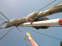
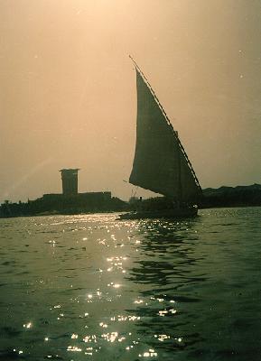
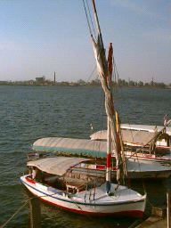
The
simple, functional sailboats that frequent the Nile today are
very similar to the sailboats that occupied this river thousands
of years ago. They are called "falucca" and they
consist of a single mast with a triangular sail. Today they are
often used by tourists as a way to see the Nile up close while
getting a feel for the main means of river transportation back in
the time of the pharaohs.