 ** Lyle Cherry Orchard
(Gorge, near Bingen, WA) : A good hike to get a feel for the dry
east end of the Columbia river gorge. The land was bought by nature
conservancy. The trail starts out in oak trees and dry grass covered hills
and climbs up at a fairly gentle uphill pace with one long exposed steep
slope to get you to the upper hills. The end point is a derelict old
orchard. I didn’t see any cherry trees. Nice views of Hood and the gorge.
The open terrain makes views better. On the return the group took a short detour
to the big sign that says Lyle on the hill side. Ticks and poison oak are
hazards on this hike.( 6 miles , 1400 ft, 3/99) **** Lower Deschutes River (Gorge, near The Dalles, OR) : A nice hike with river and
gorge views as well as a natural arch. The trail starts at Deschutes park
and ascends steeply to the top of the hills. Nice views for here of the
surrounding terrain and the gorge and Deschutes river. After this the
trail follows the ridgeline for a while. There is a train line running on
the other side of the Deschutes river. The river itself is very scenic.
The trail then gently descends to the river where numerous lunch spots
present themselves. The return is along the side of the river for a while
and then on a dirt road. There is a few places where you have to climb up
and down cattle stiles. ( 8 miles , 900 ft, 4/99) *** Indian Point Loop via
Nick Eaton Ridge and Gorton Creek trails (gorge, Near Cascade Locks, OR) : Long grueling
hike but has nice expansive views of the gorge and Adams. Lots of
switchbacks in the beginning. Then you get a brief respite as the trail levels
out for a while as it follows stretches of an abandoned forest road. Then
it takes off sharply again and continues in this manner until reaching the
top. Elevation gain is considerable. There are several open stretches that
afford good views of the Gorge. Indian Point is a rocky pinnacle with a
single tree precariously hanging on to its top. The ledge which leads to
it is a popular lunch-spot for hikers. You can descend via Gorton Creek
trail.
** Lyle Cherry Orchard
(Gorge, near Bingen, WA) : A good hike to get a feel for the dry
east end of the Columbia river gorge. The land was bought by nature
conservancy. The trail starts out in oak trees and dry grass covered hills
and climbs up at a fairly gentle uphill pace with one long exposed steep
slope to get you to the upper hills. The end point is a derelict old
orchard. I didn’t see any cherry trees. Nice views of Hood and the gorge.
The open terrain makes views better. On the return the group took a short detour
to the big sign that says Lyle on the hill side. Ticks and poison oak are
hazards on this hike.( 6 miles , 1400 ft, 3/99) **** Lower Deschutes River (Gorge, near The Dalles, OR) : A nice hike with river and
gorge views as well as a natural arch. The trail starts at Deschutes park
and ascends steeply to the top of the hills. Nice views for here of the
surrounding terrain and the gorge and Deschutes river. After this the
trail follows the ridgeline for a while. There is a train line running on
the other side of the Deschutes river. The river itself is very scenic.
The trail then gently descends to the river where numerous lunch spots
present themselves. The return is along the side of the river for a while
and then on a dirt road. There is a few places where you have to climb up
and down cattle stiles. ( 8 miles , 900 ft, 4/99) *** Indian Point Loop via
Nick Eaton Ridge and Gorton Creek trails (gorge, Near Cascade Locks, OR) : Long grueling
hike but has nice expansive views of the gorge and Adams. Lots of
switchbacks in the beginning. Then you get a brief respite as the trail levels
out for a while as it follows stretches of an abandoned forest road. Then
it takes off sharply again and continues in this manner until reaching the
top. Elevation gain is considerable. There are several open stretches that
afford good views of the Gorge. Indian Point is a rocky pinnacle with a
single tree precariously hanging on to its top. The ledge which leads to
it is a popular lunch-spot for hikers. You can descend via Gorton Creek
trail.
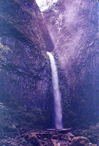
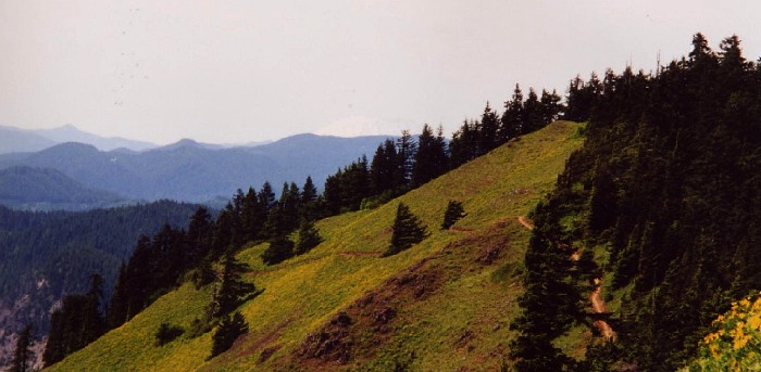
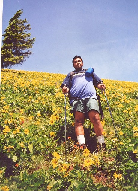
Redone in 2006 as an out-and-back hike along Gorton Creek. The road to campground was gated so added 1 mile to hike. We took Trail 406 (Herman Creek) to Trail 408 (Gorton Creek). The scramble trail to Indian Point is a few feet past Gorton Creek trail's junction with the Ridge Cutoff trail. pic: Hikers spread out like a bunch of foraging rock monkeys on Indian Point, pic: View of the gorge and Mt. Adams from Indian Point,(10 mi., 3000 ft., done 3/20/99 and 3/4/06)
 *** Angel's Rest
(gorge, near Bridal Veil falls, exit 28 off I-84) : Short hike
leads to nice views of the gorge. It is a quintessential gorge hike with
the ferns, first, rock-slide traverses and waterfalls that typify gorge
hikes. You cross a respectable waterfall called Coopey Fall soon after
starting the hike. Lots of switch-backs with good gorge views. The
destination is a flat brush-covered piece of cliff top that juts out and
provides expansive views of the gorge. It was so windy up there that we
had to literally hang onto bushes and rocks sometimes to prevent from
being bowled over. There is some evidence of a forest fire that ravaged
trees towards the end of the trail -- perhaps this explains the lack of
trees at the top of Angel's rest. Its a good quick outing in the gorge and I have done it several times. During Mazama BCEP class we made it to the top in well under 2 hours which was a new speed record for me. ( 4 miles, 1600 ft. elev. gain, done
5/23/99 and 2/21/00, 12/04,3/05) ** Devil's Rest
(gorge, near Bridal Veil falls, exit 28 off I-84) : This is a hike near Angel's Rest named
Devil's Rest by somebody who liked symmetry. It is longer and about a 1000 ft. higher but has no nice
view at the end of it -- just a bunch of moss-covered boulders. Hence I
don't recommend this hike very highly. It starts off along the Wahkeena falls trail and branches off of it once you reach the top of Wahkeena Falls. There is a short side trail to a spring along this hike.( 7 miles, 2600 ft. elev. gain, done 6/99 ) *** Hamilton mountain
(gorge, WA side near Beacon Rock) : Great views of Bonneville Dam,
Beacon rock, Mt. Adams and Hood and forested ridges. There is a short
detour to a nice waterfall called "pool of the winds". Lots of
switch-backs near the top. The summit is somewhat clogged with brushes
which obstruct the view considerably. Beware of poison oak. ( 8 miles,
2100 ft. elev. gain, done 6/13/99) pic, pic, pic, pic of self Columbia River and Beacon Rock in the
background, pic, view
of Bonneville dam from our lunch spot, pic
*** Angel's Rest
(gorge, near Bridal Veil falls, exit 28 off I-84) : Short hike
leads to nice views of the gorge. It is a quintessential gorge hike with
the ferns, first, rock-slide traverses and waterfalls that typify gorge
hikes. You cross a respectable waterfall called Coopey Fall soon after
starting the hike. Lots of switch-backs with good gorge views. The
destination is a flat brush-covered piece of cliff top that juts out and
provides expansive views of the gorge. It was so windy up there that we
had to literally hang onto bushes and rocks sometimes to prevent from
being bowled over. There is some evidence of a forest fire that ravaged
trees towards the end of the trail -- perhaps this explains the lack of
trees at the top of Angel's rest. Its a good quick outing in the gorge and I have done it several times. During Mazama BCEP class we made it to the top in well under 2 hours which was a new speed record for me. ( 4 miles, 1600 ft. elev. gain, done
5/23/99 and 2/21/00, 12/04,3/05) ** Devil's Rest
(gorge, near Bridal Veil falls, exit 28 off I-84) : This is a hike near Angel's Rest named
Devil's Rest by somebody who liked symmetry. It is longer and about a 1000 ft. higher but has no nice
view at the end of it -- just a bunch of moss-covered boulders. Hence I
don't recommend this hike very highly. It starts off along the Wahkeena falls trail and branches off of it once you reach the top of Wahkeena Falls. There is a short side trail to a spring along this hike.( 7 miles, 2600 ft. elev. gain, done 6/99 ) *** Hamilton mountain
(gorge, WA side near Beacon Rock) : Great views of Bonneville Dam,
Beacon rock, Mt. Adams and Hood and forested ridges. There is a short
detour to a nice waterfall called "pool of the winds". Lots of
switch-backs near the top. The summit is somewhat clogged with brushes
which obstruct the view considerably. Beware of poison oak. ( 8 miles,
2100 ft. elev. gain, done 6/13/99) pic, pic, pic, pic of self Columbia River and Beacon Rock in the
background, pic, view
of Bonneville dam from our lunch spot, pic
 *** Dry Creek Falls
(gorge, ) : Hike leads to nice views of the fall. Got a really
nice pic of the fall with sunlight streaming through narrow cleft from
which the water fall descends. A small old dam that supplied water to
Cascade Locks stands dismantled nearby. Continue towards Herman Creek and
some weird looking rock formations that are crumbling away and piling the
debris around their base. Beware of poison oak, which was growing
profusely along many stretches of the trail. ( 8 miles one way with car
shuttle, 800 ft. elev. gain, done 6/19/99) pic,
pic
*** Dry Creek Falls
(gorge, ) : Hike leads to nice views of the fall. Got a really
nice pic of the fall with sunlight streaming through narrow cleft from
which the water fall descends. A small old dam that supplied water to
Cascade Locks stands dismantled nearby. Continue towards Herman Creek and
some weird looking rock formations that are crumbling away and piling the
debris around their base. Beware of poison oak, which was growing
profusely along many stretches of the trail. ( 8 miles one way with car
shuttle, 800 ft. elev. gain, done 6/19/99) pic,
pic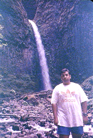
 ***** Eagle Creek (
gorge, Near Cascade Locks, OR) : A "classic" gorge hike.
I found it to be over-hyped and over-crowded. The trail climbs rapidly and
hugs the rocky ledges blasted out to make the trail. Steel cables ensure
safety where ledge is narrow and exposed. Trail runs well above the creek
for 3.5 miles to high bridge. High bridge is a nice place with tar-black
water going through a narrow slot canyon several hundred feet below you.
High bridge is a good place to turnaround, or you an go another 2 miles to
tunnel falls -- I didn't. 3 nice waterfalls along the way. Upper and lower
punch bowl falls are accessible and you can take scramble down side trails
to them. Metlako falls is the tallest but can only be viewed from afar. I
liked upper punchbowl falls best. The water is not as clear as Siouxon
creek and has a yellowish algae-tainted tinge in the shallow spots. I
think Silver Falls SP or Siouxon creek are more scenic hikes. (7 miles
roundtrip, 400 ft.). The much maligned trail park pass sign is posted here
as well, as a matter of fact the trailhead was jam-packed with cars and I
had to park about 1/2 mile away from the trailhead and still pay $3 for
that "privilege"
***** Eagle Creek (
gorge, Near Cascade Locks, OR) : A "classic" gorge hike.
I found it to be over-hyped and over-crowded. The trail climbs rapidly and
hugs the rocky ledges blasted out to make the trail. Steel cables ensure
safety where ledge is narrow and exposed. Trail runs well above the creek
for 3.5 miles to high bridge. High bridge is a nice place with tar-black
water going through a narrow slot canyon several hundred feet below you.
High bridge is a good place to turnaround, or you an go another 2 miles to
tunnel falls -- I didn't. 3 nice waterfalls along the way. Upper and lower
punch bowl falls are accessible and you can take scramble down side trails
to them. Metlako falls is the tallest but can only be viewed from afar. I
liked upper punchbowl falls best. The water is not as clear as Siouxon
creek and has a yellowish algae-tainted tinge in the shallow spots. I
think Silver Falls SP or Siouxon creek are more scenic hikes. (7 miles
roundtrip, 400 ft.). The much maligned trail park pass sign is posted here
as well, as a matter of fact the trailhead was jam-packed with cars and I
had to park about 1/2 mile away from the trailhead and still pay $3 for
that "privilege"Captain's log supplemental: I redid this hike in Dec 2001 after it had been raining for 32 consecutive days in Portland. The scenery was vastly improved this time. There were numerous side waterfalls in operation that had been dry the first time I did it. Also the water in Eagle Creek was a clear glacier blue in color and the waterfalls were much more impressive with heavy flow. Consequently I have upgraded the ranking of this trail to 5*. To catch the full impact of this hike it should be done in spring or winter.
In 2006 I went all the way to Tunnel falls. In the past, late starts and whiny female hiking companions had caused me to turn back at the High Bridge. Free of such encumberances we decided to press on after the High Bridge. The trail was just as pretty and scenic after High Bridge as before it. After crossing the bridge the trail ascended the west bank for about 1/2 mile before crossing over another bridge. There was a little legde above the creek that made for a nice lunch spot here. Shortly after 2nd bridge we came to a nice double fall (somewhat simialr to McCord falls). After this the trail continued crossing numerous side-streams. One of these crossings was unbridged but had a fallen log across it. A fairly massive waterfall thundered down nearby. Finally we came to Tunnel Falls. I thought it would be similar to the trail in Silver Falls that goes behind South Falls but I was wrong. There is an actual tunnel bored in the rock behind the falls. The fall itself is pretty spectacular and you get really close to when you go through the tunnel. Within 0.25 miles of tunnel is another spectacular waterfall that cuts through a deep slot and plunges into the lower gorge. We turned around after a snack break here. This hike is a must-do for Gorge hikers. (done 8/15/99, 12/19/01,12/02,11/14/04, 2/5/06,7 mi, 450 ft to High Bridge, 12 mi, 1100 ft to Tunnel Falls) pic : Upper punch-bowl falls , pic
***** Dog Mountain
(Columbia River Gorge near Carson, WA) : This hike is one of the
tougher cookies in the gorge. There is a sign at the trailhead warning
hikers of "plague and pestilence" in the form of ticks,
rattlesnakes and poison oak that lurk on this trail. I can confirm the
abundance of poison oak but fortunately didn't see any ticks. I did see a
pretty long tail that slithered away into bushes as I approached. Whether
it belonged to a rattlesnake or not is up to conjecture. After liberally
slathering bug-juice on all exposed body parts I started out. The trail
starts out from a trailhead along highway 14 (trail park pass crap posted
here as well). It is a dry and dusty trail and starts switchbacking up
relentlessly right from the get go. At 0.5 mi. trail forks and you get the
choice of "more hard" or "most hard" legs. I took the
scenic "more hard" leg which is 0.2 mi. longer but less steep
and has a nice open patch with views of the gorge and a hint of the
flowers to come. The first 1-2 miles are in mixed bushes and trees but
then the trail enters a cool mature forest and keeps climbing steadily up
in it for most of the remainder of the trip until it bursts out into open
meadows about 0.5 miles from the summit. Here I came across an incredible
flower-strewn hill side. The sunflower-type yellow flowers are called
balsam root and they cover the entire hillside in great profusion along
with some purplish lupine, yellow buttercups, dark blue larkspur and red Indian paintbrush . I had developed some skepticism after
going on gorge group-hikes billed as "wildflower hikes" before which
usually had a couple of flowers growing by the trail and the entire group
would ooh and ah over the measly display. This, however, fully lived up to
its billing as a flower hike. The whole place was literally carpeted with balsam root
flowers. The trail winds its way among the flowers with gorgeous views of
the Gorge, Mt. Hood , Helens and Adams to the summit at 3000 ft. Across
the river is Mt. Defiance which is the biggest, baddest, meanest hike in
the Gorge at 5000 ft. Best time to go on the Dog Mountain hike is late May
/ early June. Its very popular hike and trailhead parking is hard
sometimes. I must have run into at least a 100 people on this hike.
Carrying plenty of water, insect repellent and a shady hat would be
advisable. Another variation on this hike to make a loop (I took it first time in May 2005) is to go right at junction on way down. This trail goes along an open hill before dipping into the woods and coming down to the parking lot. Its longer but less steep.
Looking towards Augspurger Mountain, Mt. St. Helens faintly visible
On the trail (Done 6/4/00, 8 miles, 3000 ft, Redone 6/5/2003, 5/14/2005)
 **** Table Mountain (Columbia River Gorge near Stevenson) This hike can be considered a bigger brother of Dog Mountain. The trailhead is rather tricky to find. Look for a railway trestle 2 2-3 miles west of Bridge of the Gods on Hwy 14. Its near milepost 38 shortly past the Chevron station if you are going east on 14. Go under the trestle , right at the Grid Station. The road winds past a hotel and narrows. Park on the side of the road by a lake and under a big power line. Go up the roped off dirt road. Follow the dirt road to a big transmission line tower and go left on another dirt road that goes into a small valley with a stream flowing through a culvert under the road. (Don't go straight as the road will peter off at the trees). Coming out of the valley you will see the trail entering the trees on your right side right next to two huge power transmission towers. This very muddy trail crosses 3 parallel streams and comes to junction with an old logging road in 0.5 mile. Head uphill on this road until you come to a junction near a lake called Carpenter Lake on the map. Go uphill (left) and shortly thereafter you will come to a second junction with another road. Here stay right. This road/trail goes up a hill with a noisy stream running in a valley on the left side. Eventually it will lead to the PCT (It took 1.5 hours from start of hike to PCT junction for me). The PCT goes up at a gradual pace. Shortly after crossing a stream you come to the old closed-off trail for Table Mountain. The new trail junction is 0.5 mile further. The trail to Table Mountain takes off steeply through trees but breaks out into open rocky slopes very quickly. The trail surface is very rocky and loosely compacted rubble and its pretty steep all the way till reaching the summit plateau. The views are great in every direction. The trail passes some rocky outcroppings and reenters the forest but skirts the edge of it along a fairly steep cliff with large drop-offs. You finally come to a huge rock cairn marking the summit plateau. There are multiple trails meandering here but eventually one of them will bring you to the crumbling vertical face of Table Mountain overlooking the gorge. The view here is one of the best on the Washington side of the gorge. Looking west to east you can see Larch Mountain, Nesmith Point, Hamilton, Beacon Rock, Bonneville Dam, Bridge of the Gods, Wind Mountain, Dog Mountain and Hood. The steep drops on all sides are dizzying. On the way back it started to rain and hail torrentially and I had to be extremely careful on the steep, exposed and rocky trail down to PCT. This is definitely a hike where sturdy hiking boots and hiking poles are essential. ( 8 miles, 3500 ft, done partially in 12/9/2000 and completely 5/22/2005 ). **** Catherine Creek
(West) (East end of Gorge near Bingen) This is a nice spring hike
for wildflower viewing . It begins at the Catherine creek trail head and
heads up into the rolling hills on the west side of the creek (the creek
itself is not in sight for most of the hike). There were purple grass
widows, desert parsley and a few buttercups as well as some other flowers.
The pungent aroma of wild onions is very noticeable. The forest is a
mixture of oak and pine with an occasional fir. The trail winds along the
hills at a steady uphill climb with a few somewhat steep sections. Views
of gorge and Mt. Hood are pretty good. The top of this hill is where trail
ends. It makes for a nice lunch stop and turnaround point. There are
several ways to return. This area at the top was recently acquired by the
Forest Service. On return, you can follow the gently rolling hills under
the power line or take an old and rocky road (Attwater road). The road
does have the advantage of a view of the creek and a natural bridge.
Another interesting feature of this hike is globular growths called
"gauls" that are found on numerous oak trees and bushes. Wasps
sting the bark which causes the oak to secrete some fluid which solidifies
into a gaul. Wasps build these on oak trees and lay their eggs in it. The
larva hatch and leave it. This is tick and poison oak country so be
careful. (7 miles. 1500 ft, Done 3/26/01).
**** Table Mountain (Columbia River Gorge near Stevenson) This hike can be considered a bigger brother of Dog Mountain. The trailhead is rather tricky to find. Look for a railway trestle 2 2-3 miles west of Bridge of the Gods on Hwy 14. Its near milepost 38 shortly past the Chevron station if you are going east on 14. Go under the trestle , right at the Grid Station. The road winds past a hotel and narrows. Park on the side of the road by a lake and under a big power line. Go up the roped off dirt road. Follow the dirt road to a big transmission line tower and go left on another dirt road that goes into a small valley with a stream flowing through a culvert under the road. (Don't go straight as the road will peter off at the trees). Coming out of the valley you will see the trail entering the trees on your right side right next to two huge power transmission towers. This very muddy trail crosses 3 parallel streams and comes to junction with an old logging road in 0.5 mile. Head uphill on this road until you come to a junction near a lake called Carpenter Lake on the map. Go uphill (left) and shortly thereafter you will come to a second junction with another road. Here stay right. This road/trail goes up a hill with a noisy stream running in a valley on the left side. Eventually it will lead to the PCT (It took 1.5 hours from start of hike to PCT junction for me). The PCT goes up at a gradual pace. Shortly after crossing a stream you come to the old closed-off trail for Table Mountain. The new trail junction is 0.5 mile further. The trail to Table Mountain takes off steeply through trees but breaks out into open rocky slopes very quickly. The trail surface is very rocky and loosely compacted rubble and its pretty steep all the way till reaching the summit plateau. The views are great in every direction. The trail passes some rocky outcroppings and reenters the forest but skirts the edge of it along a fairly steep cliff with large drop-offs. You finally come to a huge rock cairn marking the summit plateau. There are multiple trails meandering here but eventually one of them will bring you to the crumbling vertical face of Table Mountain overlooking the gorge. The view here is one of the best on the Washington side of the gorge. Looking west to east you can see Larch Mountain, Nesmith Point, Hamilton, Beacon Rock, Bonneville Dam, Bridge of the Gods, Wind Mountain, Dog Mountain and Hood. The steep drops on all sides are dizzying. On the way back it started to rain and hail torrentially and I had to be extremely careful on the steep, exposed and rocky trail down to PCT. This is definitely a hike where sturdy hiking boots and hiking poles are essential. ( 8 miles, 3500 ft, done partially in 12/9/2000 and completely 5/22/2005 ). **** Catherine Creek
(West) (East end of Gorge near Bingen) This is a nice spring hike
for wildflower viewing . It begins at the Catherine creek trail head and
heads up into the rolling hills on the west side of the creek (the creek
itself is not in sight for most of the hike). There were purple grass
widows, desert parsley and a few buttercups as well as some other flowers.
The pungent aroma of wild onions is very noticeable. The forest is a
mixture of oak and pine with an occasional fir. The trail winds along the
hills at a steady uphill climb with a few somewhat steep sections. Views
of gorge and Mt. Hood are pretty good. The top of this hill is where trail
ends. It makes for a nice lunch stop and turnaround point. There are
several ways to return. This area at the top was recently acquired by the
Forest Service. On return, you can follow the gently rolling hills under
the power line or take an old and rocky road (Attwater road). The road
does have the advantage of a view of the creek and a natural bridge.
Another interesting feature of this hike is globular growths called
"gauls" that are found on numerous oak trees and bushes. Wasps
sting the bark which causes the oak to secrete some fluid which solidifies
into a gaul. Wasps build these on oak trees and lay their eggs in it. The
larva hatch and leave it. This is tick and poison oak country so be
careful. (7 miles. 1500 ft, Done 3/26/01).View of Rowland Lake and Columbia River from trail
Meadow at the top
*** Wahkeena Falls
(Gorge, near Exit 28 on I-84) This is an excellent hike with lots
of bang for your buck. Trail starts out steeply and switchbacks to the top
of the waterfall. Then parallels the gushing stream past numerous
pseudo-waterfalls. After a while you come to a junction. Going
right will take you towards Angels Rest and going left takes you towards
Larch crater and upper Multnomah falls. I headed left and went towards the
upper Mult. falls. Trail was really muddy and slick because of rain. The rain transitioned into slushy snow as I climbed higher. The trail comes to a junction and then starts heading down towards Multnomah Falls. This was my first hike with my newly adopted dog and I was quite encouraged by his stamina and trail etiquette. This trail has occasional views of the gorge but mostly its a forest and water kind of
hike. A variation of this hike is to continue on to Multnomah creek and then descend into the crowds around Mult. Falls. The last 1/2 mile on a trail parallelling the road makes it a sceninc 5 miles, 1700 ft loop (6 miles. 1500 ft, Done 4/14/01. Loop done in 2005 and 1/15/2006).Wahkeena Falls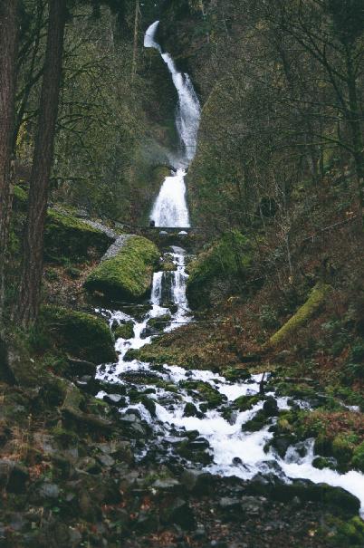 ** Mt. Defiance -- South
(10 miles north Dee, OR) An easy backdoor way to get to the
highest point in the gorge. Unfortunately it was a cloudy day so I didn't
get to see much but the unsightly transmission tower at the top. The
trail head is reached after a long drive, the last 10 miles on a good
gravel road. The trail starts out in huckleberry bushes and soon enters a
medium age forest. There are very few views except for a couple of places
where the trail crosses exposed rock slide areas. The elevation gain is
1500 ft for trail but it feels less because of the moderate and steady
grade. It steepens a little bit as it approaches the summit. The trail
pops out on a rocky area and then suddenly you are at the top. There is a
depressing looking micro-wave tower and a dirt road leading to it. Made me
glad I hadn't done the 5000 ft climb to get to this depressing viewpoint.
The fact that it was raining buckets and a freezing wind was howling
through the trees didn’t help improve my impression of the summit. The
members of the hiking group scattered into the trees to get some shelter
and munch somberly on soggy sandwiches. We left as soon as we could, glad
to get out of the chilling wind. On the way back we hit the Bear Lake
which is accessed by a mile long side trail. The lake view wasn't much
better than the summit view as the whole surface was hidden by fog/clouds.
Towards the end the clouds did lift off the lake in a pretty manner
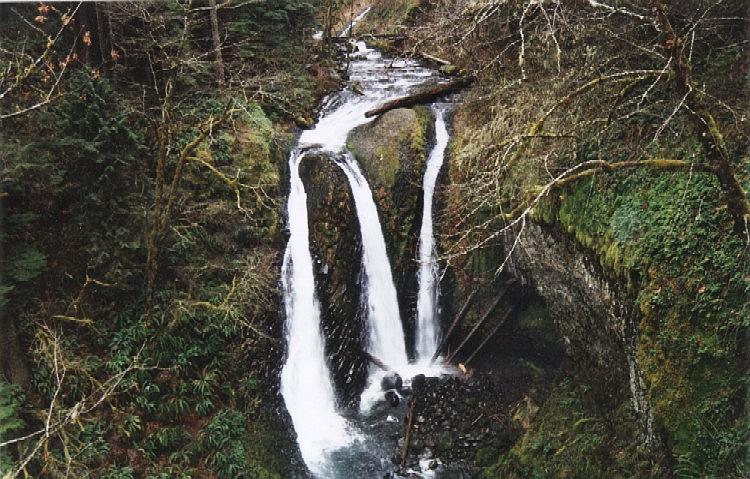
revealing a medium sized lake. (5 mi., 1500 ft, Done 7/28/01). *** Triple Falls
(Columbia Gorge, 3 miles east of Multnomah Falls): Did this hike
as an opening celebration of the company shutdown over the next 2 weeks.
The Ainsworth exit off of 84 was blocked off so had to drive all the way
along old Columbia River Highway to get to the trailhead. The trail
quickly left the road and came to a junction. I headed left towards
Oneonata Gorge. The pace was a steady uphill. There was a side loop
overlooking the gorge a short distance thereafter. Then the trail curved
into the scenic side gorge cut by Oneonata creek. The trees are heavily
festooned with moss in this area and look almost a bright neon green in
the winter light. The trail stayed considerably above the stream and
switchbacked up the side of a hill before finally leveling off a little
near the viewpoint for Triple falls. The falls are an impressive 3-pronged
affair. The three channels have dug deep grooves in the volcanic rock and
the separating prows of rock between the waterfall branches look very
striking. I had my snack and admired the view. A couple of possible gay
guys passed by with their two dogs. Diamir lost no time in making "friends"
with one of the dogs and then humping him -- much to the amusement of the
gay duo. Later I wandered a little way up to where trail crossed above the
falls on a bridge. This was the only place where the trail came close to
the stream. I lost my nice pen knife at this point. Probably left
carelessly on a log after peeling an orange. Return went a lot faster than
expected. Decided against doing the loop to horsetail falls since it was
too dark to see anything anyway. Did the last part of the hike with a
flashlight. (5 mile, 1500 ft, Done 12/22/01)
** Mt. Defiance -- South
(10 miles north Dee, OR) An easy backdoor way to get to the
highest point in the gorge. Unfortunately it was a cloudy day so I didn't
get to see much but the unsightly transmission tower at the top. The
trail head is reached after a long drive, the last 10 miles on a good
gravel road. The trail starts out in huckleberry bushes and soon enters a
medium age forest. There are very few views except for a couple of places
where the trail crosses exposed rock slide areas. The elevation gain is
1500 ft for trail but it feels less because of the moderate and steady
grade. It steepens a little bit as it approaches the summit. The trail
pops out on a rocky area and then suddenly you are at the top. There is a
depressing looking micro-wave tower and a dirt road leading to it. Made me
glad I hadn't done the 5000 ft climb to get to this depressing viewpoint.
The fact that it was raining buckets and a freezing wind was howling
through the trees didn’t help improve my impression of the summit. The
members of the hiking group scattered into the trees to get some shelter
and munch somberly on soggy sandwiches. We left as soon as we could, glad
to get out of the chilling wind. On the way back we hit the Bear Lake
which is accessed by a mile long side trail. The lake view wasn't much
better than the summit view as the whole surface was hidden by fog/clouds.
Towards the end the clouds did lift off the lake in a pretty manner
revealing a medium sized lake. (5 mi., 1500 ft, Done 7/28/01). *** Triple Falls
(Columbia Gorge, 3 miles east of Multnomah Falls): Did this hike
as an opening celebration of the company shutdown over the next 2 weeks.
The Ainsworth exit off of 84 was blocked off so had to drive all the way
along old Columbia River Highway to get to the trailhead. The trail
quickly left the road and came to a junction. I headed left towards
Oneonata Gorge. The pace was a steady uphill. There was a side loop
overlooking the gorge a short distance thereafter. Then the trail curved
into the scenic side gorge cut by Oneonata creek. The trees are heavily
festooned with moss in this area and look almost a bright neon green in
the winter light. The trail stayed considerably above the stream and
switchbacked up the side of a hill before finally leveling off a little
near the viewpoint for Triple falls. The falls are an impressive 3-pronged
affair. The three channels have dug deep grooves in the volcanic rock and
the separating prows of rock between the waterfall branches look very
striking. I had my snack and admired the view. A couple of possible gay
guys passed by with their two dogs. Diamir lost no time in making "friends"
with one of the dogs and then humping him -- much to the amusement of the
gay duo. Later I wandered a little way up to where trail crossed above the
falls on a bridge. This was the only place where the trail came close to
the stream. I lost my nice pen knife at this point. Probably left
carelessly on a log after peeling an orange. Return went a lot faster than
expected. Decided against doing the loop to horsetail falls since it was
too dark to see anything anyway. Did the last part of the hike with a
flashlight. (5 mile, 1500 ft, Done 12/22/01)
In 2006 I continued past triple falls. The trail climbed along the creek swollen with winter rains. In fact it rained on us throughout the hike. Had a soggy lunch on some mossy boulders along the creek. After a while we came to a second bridge that crossed back to true left bank. Here we came to a big trail junction with trails leading off to Nesmith and Franklin. The trail sign was obscured by a lot of downed trees right at the junction. We opted for Franklin. After this the trail switchbacked steadily up towards Franklin ridge. We followed it quite a ways until the views opened up towards the Nesmith side of the valley. Franklin Ridge can be taken all the way to Multnomah Falls. However that would have required a car shuttle or a long walk along the road back to Horsetail Falls. So we decided to turn back before reaching the top of Franklin Ridge. View of Triple Falls .
 ***** Tom McCall Point and beyond (Gorge near Mosier, OR) : A great spring wild-flower
hike. The Friends of the Gorge organized this jaunt as a shuttle hike. We
started cross-country from the shoulder along Dell Road. The
"trail" descended sharply into a ravine and then climbed up to a
meadow on the other side. This meadow was quite pretty with the sunflower-like
Balsam Root, lupine and white and purple vetches in bloom. Mt. Adams also
became visible at this point. More and more of its snow-covered bulk
became visible as the trail ascended in oak forest. After a fairly
strenuous climb we came out on a saddle behind McCall point. We continued
along the top of the ridge to a couple of meadows. Had lunch in the first
flower-strewn meadow with glorious view of Mt. Hood. The trail leaders
were extremely knowledgeable about plants and identified things like
desert parsley, wild onion, chocolate lilies, glacier lilies (flowers were
gone), locoweed, grandma’s pincushion etc. They also related the story
about how every lupine flower hides a wolf's claw. Its amazing to notice
the amount of plant diversity that exists even in a few square feet of
forest floor. After lunch we meandered along the ridge top until the trail
petered out at private property. There was one particularly pretty
viewpoint along the way of Mt. Adams. The only thing marring this
viewpoint was the rotting hulk of a mattress thrown nearby. Wire fences
confined the trail to a small portion of the ridge top bringing home the
patchwork nature of public land in this area. Even the land we were
walking on was saved from development by the Nature Conservancy. After the
viewpoint we turned back and went down via McCall point. Glorious views of
the river, Mt. Adams and Mt. Hood from McCall point. The path down from
McCall point is a long series of switchbacks in oak forest. Definitely an
excellent flower and view hike. I developed a blister on my left toe on
the way down. This was the first hike since I got my trusty Tecnica Ranger
boots resoled. I am beginning to suspect the resoling may have altered the
boot's fit. Maybe its time to get a new pair. Poison Oak was abundant
throughout this hike. (7 miles, 1200 ft, done 5/12/2002) ***** Multnomah Falls to Nesika Lodge (Columbia River Gorge) : This was a group hike sponsored by the Trails club and Friends of the Gorge. The hike started at the crowded Mutlnomah Falls parking lot. The number of people on trail dropped in proportion to the inverse of the square of the distance from the trailhead. After the top of the fall viewpoint the trail lost its touristy nature and became a real hike as it gradually climbed along the scenic Multnomah Creek. Numerous smaller waterfalls exist along the trail and are hikeworthy in their own right even though the big Multnomah Falls steals all the glory. The trail crossed back and forth across the stream a couple of times on sturdy bridges. After about 3 miles of hiking a couple of nice campsites also showed up along the stream. Vegetation is luxurious rain forest with several different ferns, columbines, Canadian dogwood and devils club. Large old growth fir and cedar trees also dot the forest. The Forest Service planned to clear cut all the way to Multnomah Falls in 1933 but the Trails Club and other environmentalists managed to dissuade them. The Nesika Lodge is tucked away towards the end of the trail near the junction with the Larch Mountain trail. It is built on an old homestead site and is owned by the Trails Club of Oregon who had graciously opened it for the group. They had even prepared coffee and cookies and had a nice fire burning. The cloudy day and the chill in the air made the warm lodge even more welcoming as the lunch spot. There is also a great viewpoint of the Gorge a short walk from the lodge. The rustic outhouse near the lodge had no doors so the user can look out at the gorge. Definitely a shit with a view. (Maybe somebody should compile "The best 100 places to shit in the NW" book). A good gorge hike. (8 miles, 2000 ft, done 6/16/2002) *** Wahclella Falls (Columbia Gorge): This is a short leg-stretcher in the gorge. Trail started out level and soon passed a dam. Then it passed a nice side fall that seemed like a slide in a water park. After climbing up a little bit the trail came to a fork. There used to be a loop here but the bridge was washed out so keep to the left. The falls are an impressive two-tiered affair with a big pool underneath. The spray from the fall made this portion of the trail a little slick. The trail crossed over the creek and there was a very pretty wispy little waterfall on the other side that kinda dribbled down the mossy rock face. The lower bridge was being rebuilt when I redid this hike in June 2003, the wispy waterfall had dried up by then. (3 miles, 200 ft, Done 12/2002, 6/10/2003). *** Chenoweth-Table (Columbia Gorge): This was an offering on the 2003 spring hiking schedule of the Friends of the Gorge. I decided to go on it since it was something I had never heard of before. Apparently it is a land parcel recently acquired by the forest service. The trailhead lies at the back of Chenoweth High School in the Dalles. We started off in oak forest which tranistioned into mixed pine and oak forest which is very typical of this area. The hike leader was a walking encyclopedia on the local flora. She identified everything from orange fiddlenecks to mariposa lilies. Other flowers were small white prairie stars, yellow senecio, larkspur, lupine, balsam root, yaro, desert parsley aka indian celery and large pink pentesmons. Also tons of poison oak. After a couple of miles we went off-trail and climbed a hillside. We passed close to a red-tail hawk's nest. The hawk was understandably quite pissed at the herd of about 50 people tromping so close to its nest. It emitted shrill warning cries as it circled over its nest in a pine tree. After a while we reached a small waterfall trickling over a large rocky overhang. After a pleasant lunch at the falls, we continued our climb to the top of the chenoweth table. The top is flat grassland except for mysterious bumps called "biscuit swells". These are large dirt mounds about 20 feet across which were covered with balsam root. The balsam root favors these mounds for the deep soil they provide for its roots. The origin of these biscuit swells is still unexplained and many theories try to explain their existence including volcanic ash depsoits to earthquakes. However none of these explanantions are totally convincing. Evidence of ancient Missoula Flood was also visible on the nearby 7-mile Hill. The area below 700 ft. elevation was scabbed with rock as the top soil had been scoured away by the flood. The hills above this line were smooth. We circled the top of the table to a rocky overlook with a great view of the entire city of The Dalles as well as an S-shaped bend in the Columbia River.The usually drab brown hills on both sides of the Gorge were a verdant green due to the spring rains. We then descended back to the high school using a well-worn trail. The rains that were drenching Portland held off all day at The Dalles, thereby enabling us to have a very pleasant hike(6 miles, 500 ft, Done 4/26/2003). **** Elowah Falls / McCord Creek (Gorge): Another nice gorge hike . Trail had a lot of poison oak. After a short distance there is a fork. The lower trail was closed with pink tape but we went down anyway. There was a small wash-out further down which was the cause of this shutdown. Elowah Fall is a nice 300 ft tall waterfall with realtively large overhang and low waterflow so the water was being blown sideways by the time it hit the bottom. After retracing our steps to the junction we continued on the upper trail to McCord Falls. The trail passed some corroded old iron pipes and then went through an exposed section with railings. There are nice views of the gorge and an overlook of Elowah Falls in this section. McCord Falls is a small two pronged terraced waterfall. The trail bypassed a huge fallen log and ended at a small waterfall with a pool. I had lunch here and then we turned back.(3 miles, 500 ft, Done 6/10/2003). **** Wahkeena-Multnomah Loop (Columbia River Gorge, OR): Basically it combines the Multnomah and Wahkeena fall hikes so you get the best of both of them. The donwside is a half mile walk along the road back to your car. We started from the Wahkeena side. The trail switchbacks along stunning stream scenery including lacy Fairy Falls . After a whiel we reached the connector trail which branched off to the left. This brought us to a large trail junction and we headed down to Multnomah creek from there. There were several nice waterfalls on Multnomah creek as well. (5.5 miles, 1650 ft elevation gain, Done 1/2/05) *** Larch Mountain (Columbia River Gorge, OR): This was our 2nd conditioning hike/death march with the Mazamas during Basic Climb School. Most of it is a blur since we had little to no time to enjoy the scenery, what with the fast pace and being loaded down with ropes and heavy packs. My heart rate monitor hit 160 on the 1st mile and pretty much stayed there for the rest of the way. The scenery was impressive till the junction with Larch mtn trail. Numerous waterfalls and a pretty stream. After that the trail steadily gained elevation in forest with no views till the end. The steps up to Sherard Point were quite icy and we gingerly kicked steps up to the viewpoint for a brief 20 minute lunch and then rushed down at the same break-neck speed with which we had ascended. My experiment with arch supports in boot didn't work out too well and I almost got blisters on my heels. In summer one can just drive up to this viewpoint but we earned it the hard way. (14 miles, 4000 ft elevation gain, Done 4/2/05) ** Nesmith Point (Columbia River Gorge, OR): This was another conditioning hike but mercifully we did this on our own, without the group. The weather was absolutely miserable and it rained on us throughout the hike. The trail was flat for 1st half mile and then switchbacked non-stop until reaching the ridge top and leveling out a little bit. We encountered snow on this final ridge. Plenty of slick mud caused me to slip on the way down. The Nesmith point itself was totally unremarkable. It consisted of two tree rounds and a curiously bent sign embedded into a tree. There was no view, we were in clouds and a strong chill wind was blowing rain sideways. Apart from the conditioning there was no value whatsoever to doing this hike. (10 miles, 3800 ft elevation gain, Done 4/16/05) ** Mt. Defiance -- North (Columbia River Gorge, OR): This was the last of the Mazama conditioning hikes. We started out early around 7:30 am from the trailhead. he frist mile was level as it passed three nice waterfalls. Then the ascent began. Relentless switchbacks for a mile led up a ridge to a small viewpoint. We took a break here and munched on some boiled eggs. Fog floated in and out of the trees adding a mystical touch. The trail flattened out all too briefly for 0.2 miles on the ridge before beginning a steep climb to the top. There were no switchbacks here and it made for some gruelling hiking. I again developed some hot spots on my ankles and had to apply mole skin. After a seemingly endless slog up this slope we finally emerged at the edge of a large talus field. Our understanding was that this was the turn-around spot but the rest of the group had found a trail in the snow and followed it to the summit. We had no choice but to follow. This section was not as steep and offered good views down to the river.Unfortunately we were too exhausted to enjoy the scenery. It was too cloudy to see any mountains. A 2 mile slog through the snow-covered talus finally led us to a dirt road which was developed to service the radio towers at the summit. The summit was pretty ugly with industrial junk, radio towers and a big propane tank. It did have expansive view of the gorge and farms in the Hood River valley. A brief lunch break and then a long knee-busting slog down to the cars. I had brought 2 knee and 2 ankle braces and they came in very handy on the way down. Again this hike is one of those things that has very little bang for the buck in terms of views. The Mazamas seem to have a knack for picking these viewless slogs as conditioners. Most of them have knee problems at a fairly young age and their penchant for doing these hikes is no doubt partly to blame. (12 miles, 5000 ft elevation gain, Done 4/24/05) * Gillette Lake / Greenleaf Overlook (Columbia River Gorge, WA): A late season hike when all else is closed. After spending the night at Bonneville Hot Springs I chickened out of attempting Table Mountain. There had been a lot of snow last week and Table presented a fearsome countenance. The hike began from a large well-marked TH right off Highway 14. The Tamanous connector trail met up with PCT after a muddy 0.5 miles. The PCT meandered through some ugly clear cuts on private property before entering a little bit of decent forest. After about 1 hour of hiking I emerged at a well-maintained dirt road. It seemed like a total waste of effort to have hiked here when I could have just driven. The lake was in a hollow on the other side of this road. It was a pretty blue/turqoise color with a stream emptying into it. The area of lakeshore near the stream was nice and grassy but the rest was choked with thorny bushes and brambles. I saw some signs of beaver activity here with freshly gnawed trees. The view was somewhat marred by a high-tension power transmission line running close by. There was a large group of kids camping by the lake and one of them mentioned a beaver dam at the narrow end of the lake. The trail skirted the lake and continued up to more crossings of ugly roads and natural gas pipeline corridors. There were nice views of snow-covered mountains on the Oregon side but Table Mtn remained shrouded in clouds. I passed by a dark lake with a very still mirror-like surface. Shortly thereafter the trail crossed a nice-size stream on a wood bridge with an exceptionally slimy and slippery surface deck. Then it ascended through more forest before reaching the overlook. I sat here briefly and munched on some nuts while picking out the burrs from my clothes. The return was pretty uneventful except my ankle hurting like crazy for no apparent reason. On the whole a pretty mediocre hike, made all the more depressing by the weather and tons of withered leafs littering the trail. (7 miles, 500 ft elevation gain, Done 12/4/05) *** Swale Canyon (Columbia River Gorge, WA): This was a "Friends of the gorge" springflower hike. The trailhead is close to the intersection of Harms Rd and Canyonville Hwy 14 miles from Lyle, WA. Certainly well off the beaten path. We parked next to a pit toilet (provided by some hiking club) and started hiking along an old rail-road grade. Apparently this is part of the Klickitat trail system. There was a small stream running along the trail. Several rusting pieces of iron-mongery were all that remained of the railway tracks. We passed through a couple of gates and over a few trestles. The scenery was pretty nice and the sunny day made everything look crisp and sharp . We started with small rugged basalt cliffs around us that transitioned into large rounded hills dotted with tufts of sage grass. The only flowers in evidence were yellow desert parsley, purple columbia parsley (notable for coming out first as a flower and then producing leaves), dalles mtn. buttercups and yellow sun stars. The canyon transitioned from bare rolling hills to pine forest as we went down towards the Columbia River. The area surrounding the trail was all private property fenced off with wire fencing. We turned around after 3 miles at the start of the forest transition, however the trail can be taken 13 miles down to the gorge. We also came across a large herd of 15 deer up on the slopes. They broke into a run on seeing us and soon vanished over the top. The hike leader mentioned that mountain lions have been spotted here stalking the deer. This whole area has a timeless quality to it. On return I found a huge tick crawling on my pants, Other hikers also had ticks on their clothes despite it being very cold. Since it was a relatively short hike we decide to go to Horsethief Butte and putter around. I ran into a bunch of Mazama ICS students, including one of the assistants from our BCEP class, doing rock climbing practice. (6 miles, 300 ft elevation gain, Done 4/18/06) *** Cape Horn (Columbia River Gorge, WA): This hike is a relatively new addition to the gorge hikes. Its partially on private land hence less publicised. The trail started at a Park & Ride just after Hwy 14 comes down from the cliffs. The initial portion was pretty sunny since the bare oak trees did not provide much shade. Nicely graded trail switchbacked most of the way with a small steep section just before the first viewpoint. After this the trail paralleled the cliff face along an old gravel pit. Several nice views of the gorge with Larch Mountain dominating the view across the Columbia. Soon after the 2nd viewpoint the trail descended to an old dirt road before emerging on a paved road in the middle of farmland. It became more trail-like after cutting across some fields and passing a big house that has been purchased by the Friends of the Gorge. Soon we descended back to the highway, passing a stream and an delapidated old shack along the way. The busy highway was a little daunting to cross but thankfully the traffic was not too heavy. We crossed several streams and a nice waterfall before bottoming out just above a train tunnel along the Columbia River. This was proabably the most scenic part of the hike with the trail hugging cliffs of pillow lava about 50 ft above the river. The final icing on the cake was a quick walk behind a lacy waterfall. The last stretch of the hike is along a paved private road back to the Park & Ride. (8 miles, 1400 ft elevation gain, Done 4/30/06 , 3/17/07)
***** Tom McCall Point and beyond (Gorge near Mosier, OR) : A great spring wild-flower
hike. The Friends of the Gorge organized this jaunt as a shuttle hike. We
started cross-country from the shoulder along Dell Road. The
"trail" descended sharply into a ravine and then climbed up to a
meadow on the other side. This meadow was quite pretty with the sunflower-like
Balsam Root, lupine and white and purple vetches in bloom. Mt. Adams also
became visible at this point. More and more of its snow-covered bulk
became visible as the trail ascended in oak forest. After a fairly
strenuous climb we came out on a saddle behind McCall point. We continued
along the top of the ridge to a couple of meadows. Had lunch in the first
flower-strewn meadow with glorious view of Mt. Hood. The trail leaders
were extremely knowledgeable about plants and identified things like
desert parsley, wild onion, chocolate lilies, glacier lilies (flowers were
gone), locoweed, grandma’s pincushion etc. They also related the story
about how every lupine flower hides a wolf's claw. Its amazing to notice
the amount of plant diversity that exists even in a few square feet of
forest floor. After lunch we meandered along the ridge top until the trail
petered out at private property. There was one particularly pretty
viewpoint along the way of Mt. Adams. The only thing marring this
viewpoint was the rotting hulk of a mattress thrown nearby. Wire fences
confined the trail to a small portion of the ridge top bringing home the
patchwork nature of public land in this area. Even the land we were
walking on was saved from development by the Nature Conservancy. After the
viewpoint we turned back and went down via McCall point. Glorious views of
the river, Mt. Adams and Mt. Hood from McCall point. The path down from
McCall point is a long series of switchbacks in oak forest. Definitely an
excellent flower and view hike. I developed a blister on my left toe on
the way down. This was the first hike since I got my trusty Tecnica Ranger
boots resoled. I am beginning to suspect the resoling may have altered the
boot's fit. Maybe its time to get a new pair. Poison Oak was abundant
throughout this hike. (7 miles, 1200 ft, done 5/12/2002) ***** Multnomah Falls to Nesika Lodge (Columbia River Gorge) : This was a group hike sponsored by the Trails club and Friends of the Gorge. The hike started at the crowded Mutlnomah Falls parking lot. The number of people on trail dropped in proportion to the inverse of the square of the distance from the trailhead. After the top of the fall viewpoint the trail lost its touristy nature and became a real hike as it gradually climbed along the scenic Multnomah Creek. Numerous smaller waterfalls exist along the trail and are hikeworthy in their own right even though the big Multnomah Falls steals all the glory. The trail crossed back and forth across the stream a couple of times on sturdy bridges. After about 3 miles of hiking a couple of nice campsites also showed up along the stream. Vegetation is luxurious rain forest with several different ferns, columbines, Canadian dogwood and devils club. Large old growth fir and cedar trees also dot the forest. The Forest Service planned to clear cut all the way to Multnomah Falls in 1933 but the Trails Club and other environmentalists managed to dissuade them. The Nesika Lodge is tucked away towards the end of the trail near the junction with the Larch Mountain trail. It is built on an old homestead site and is owned by the Trails Club of Oregon who had graciously opened it for the group. They had even prepared coffee and cookies and had a nice fire burning. The cloudy day and the chill in the air made the warm lodge even more welcoming as the lunch spot. There is also a great viewpoint of the Gorge a short walk from the lodge. The rustic outhouse near the lodge had no doors so the user can look out at the gorge. Definitely a shit with a view. (Maybe somebody should compile "The best 100 places to shit in the NW" book). A good gorge hike. (8 miles, 2000 ft, done 6/16/2002) *** Wahclella Falls (Columbia Gorge): This is a short leg-stretcher in the gorge. Trail started out level and soon passed a dam. Then it passed a nice side fall that seemed like a slide in a water park. After climbing up a little bit the trail came to a fork. There used to be a loop here but the bridge was washed out so keep to the left. The falls are an impressive two-tiered affair with a big pool underneath. The spray from the fall made this portion of the trail a little slick. The trail crossed over the creek and there was a very pretty wispy little waterfall on the other side that kinda dribbled down the mossy rock face. The lower bridge was being rebuilt when I redid this hike in June 2003, the wispy waterfall had dried up by then. (3 miles, 200 ft, Done 12/2002, 6/10/2003). *** Chenoweth-Table (Columbia Gorge): This was an offering on the 2003 spring hiking schedule of the Friends of the Gorge. I decided to go on it since it was something I had never heard of before. Apparently it is a land parcel recently acquired by the forest service. The trailhead lies at the back of Chenoweth High School in the Dalles. We started off in oak forest which tranistioned into mixed pine and oak forest which is very typical of this area. The hike leader was a walking encyclopedia on the local flora. She identified everything from orange fiddlenecks to mariposa lilies. Other flowers were small white prairie stars, yellow senecio, larkspur, lupine, balsam root, yaro, desert parsley aka indian celery and large pink pentesmons. Also tons of poison oak. After a couple of miles we went off-trail and climbed a hillside. We passed close to a red-tail hawk's nest. The hawk was understandably quite pissed at the herd of about 50 people tromping so close to its nest. It emitted shrill warning cries as it circled over its nest in a pine tree. After a while we reached a small waterfall trickling over a large rocky overhang. After a pleasant lunch at the falls, we continued our climb to the top of the chenoweth table. The top is flat grassland except for mysterious bumps called "biscuit swells". These are large dirt mounds about 20 feet across which were covered with balsam root. The balsam root favors these mounds for the deep soil they provide for its roots. The origin of these biscuit swells is still unexplained and many theories try to explain their existence including volcanic ash depsoits to earthquakes. However none of these explanantions are totally convincing. Evidence of ancient Missoula Flood was also visible on the nearby 7-mile Hill. The area below 700 ft. elevation was scabbed with rock as the top soil had been scoured away by the flood. The hills above this line were smooth. We circled the top of the table to a rocky overlook with a great view of the entire city of The Dalles as well as an S-shaped bend in the Columbia River.The usually drab brown hills on both sides of the Gorge were a verdant green due to the spring rains. We then descended back to the high school using a well-worn trail. The rains that were drenching Portland held off all day at The Dalles, thereby enabling us to have a very pleasant hike(6 miles, 500 ft, Done 4/26/2003). **** Elowah Falls / McCord Creek (Gorge): Another nice gorge hike . Trail had a lot of poison oak. After a short distance there is a fork. The lower trail was closed with pink tape but we went down anyway. There was a small wash-out further down which was the cause of this shutdown. Elowah Fall is a nice 300 ft tall waterfall with realtively large overhang and low waterflow so the water was being blown sideways by the time it hit the bottom. After retracing our steps to the junction we continued on the upper trail to McCord Falls. The trail passed some corroded old iron pipes and then went through an exposed section with railings. There are nice views of the gorge and an overlook of Elowah Falls in this section. McCord Falls is a small two pronged terraced waterfall. The trail bypassed a huge fallen log and ended at a small waterfall with a pool. I had lunch here and then we turned back.(3 miles, 500 ft, Done 6/10/2003). **** Wahkeena-Multnomah Loop (Columbia River Gorge, OR): Basically it combines the Multnomah and Wahkeena fall hikes so you get the best of both of them. The donwside is a half mile walk along the road back to your car. We started from the Wahkeena side. The trail switchbacks along stunning stream scenery including lacy Fairy Falls . After a whiel we reached the connector trail which branched off to the left. This brought us to a large trail junction and we headed down to Multnomah creek from there. There were several nice waterfalls on Multnomah creek as well. (5.5 miles, 1650 ft elevation gain, Done 1/2/05) *** Larch Mountain (Columbia River Gorge, OR): This was our 2nd conditioning hike/death march with the Mazamas during Basic Climb School. Most of it is a blur since we had little to no time to enjoy the scenery, what with the fast pace and being loaded down with ropes and heavy packs. My heart rate monitor hit 160 on the 1st mile and pretty much stayed there for the rest of the way. The scenery was impressive till the junction with Larch mtn trail. Numerous waterfalls and a pretty stream. After that the trail steadily gained elevation in forest with no views till the end. The steps up to Sherard Point were quite icy and we gingerly kicked steps up to the viewpoint for a brief 20 minute lunch and then rushed down at the same break-neck speed with which we had ascended. My experiment with arch supports in boot didn't work out too well and I almost got blisters on my heels. In summer one can just drive up to this viewpoint but we earned it the hard way. (14 miles, 4000 ft elevation gain, Done 4/2/05) ** Nesmith Point (Columbia River Gorge, OR): This was another conditioning hike but mercifully we did this on our own, without the group. The weather was absolutely miserable and it rained on us throughout the hike. The trail was flat for 1st half mile and then switchbacked non-stop until reaching the ridge top and leveling out a little bit. We encountered snow on this final ridge. Plenty of slick mud caused me to slip on the way down. The Nesmith point itself was totally unremarkable. It consisted of two tree rounds and a curiously bent sign embedded into a tree. There was no view, we were in clouds and a strong chill wind was blowing rain sideways. Apart from the conditioning there was no value whatsoever to doing this hike. (10 miles, 3800 ft elevation gain, Done 4/16/05) ** Mt. Defiance -- North (Columbia River Gorge, OR): This was the last of the Mazama conditioning hikes. We started out early around 7:30 am from the trailhead. he frist mile was level as it passed three nice waterfalls. Then the ascent began. Relentless switchbacks for a mile led up a ridge to a small viewpoint. We took a break here and munched on some boiled eggs. Fog floated in and out of the trees adding a mystical touch. The trail flattened out all too briefly for 0.2 miles on the ridge before beginning a steep climb to the top. There were no switchbacks here and it made for some gruelling hiking. I again developed some hot spots on my ankles and had to apply mole skin. After a seemingly endless slog up this slope we finally emerged at the edge of a large talus field. Our understanding was that this was the turn-around spot but the rest of the group had found a trail in the snow and followed it to the summit. We had no choice but to follow. This section was not as steep and offered good views down to the river.Unfortunately we were too exhausted to enjoy the scenery. It was too cloudy to see any mountains. A 2 mile slog through the snow-covered talus finally led us to a dirt road which was developed to service the radio towers at the summit. The summit was pretty ugly with industrial junk, radio towers and a big propane tank. It did have expansive view of the gorge and farms in the Hood River valley. A brief lunch break and then a long knee-busting slog down to the cars. I had brought 2 knee and 2 ankle braces and they came in very handy on the way down. Again this hike is one of those things that has very little bang for the buck in terms of views. The Mazamas seem to have a knack for picking these viewless slogs as conditioners. Most of them have knee problems at a fairly young age and their penchant for doing these hikes is no doubt partly to blame. (12 miles, 5000 ft elevation gain, Done 4/24/05) * Gillette Lake / Greenleaf Overlook (Columbia River Gorge, WA): A late season hike when all else is closed. After spending the night at Bonneville Hot Springs I chickened out of attempting Table Mountain. There had been a lot of snow last week and Table presented a fearsome countenance. The hike began from a large well-marked TH right off Highway 14. The Tamanous connector trail met up with PCT after a muddy 0.5 miles. The PCT meandered through some ugly clear cuts on private property before entering a little bit of decent forest. After about 1 hour of hiking I emerged at a well-maintained dirt road. It seemed like a total waste of effort to have hiked here when I could have just driven. The lake was in a hollow on the other side of this road. It was a pretty blue/turqoise color with a stream emptying into it. The area of lakeshore near the stream was nice and grassy but the rest was choked with thorny bushes and brambles. I saw some signs of beaver activity here with freshly gnawed trees. The view was somewhat marred by a high-tension power transmission line running close by. There was a large group of kids camping by the lake and one of them mentioned a beaver dam at the narrow end of the lake. The trail skirted the lake and continued up to more crossings of ugly roads and natural gas pipeline corridors. There were nice views of snow-covered mountains on the Oregon side but Table Mtn remained shrouded in clouds. I passed by a dark lake with a very still mirror-like surface. Shortly thereafter the trail crossed a nice-size stream on a wood bridge with an exceptionally slimy and slippery surface deck. Then it ascended through more forest before reaching the overlook. I sat here briefly and munched on some nuts while picking out the burrs from my clothes. The return was pretty uneventful except my ankle hurting like crazy for no apparent reason. On the whole a pretty mediocre hike, made all the more depressing by the weather and tons of withered leafs littering the trail. (7 miles, 500 ft elevation gain, Done 12/4/05) *** Swale Canyon (Columbia River Gorge, WA): This was a "Friends of the gorge" springflower hike. The trailhead is close to the intersection of Harms Rd and Canyonville Hwy 14 miles from Lyle, WA. Certainly well off the beaten path. We parked next to a pit toilet (provided by some hiking club) and started hiking along an old rail-road grade. Apparently this is part of the Klickitat trail system. There was a small stream running along the trail. Several rusting pieces of iron-mongery were all that remained of the railway tracks. We passed through a couple of gates and over a few trestles. The scenery was pretty nice and the sunny day made everything look crisp and sharp . We started with small rugged basalt cliffs around us that transitioned into large rounded hills dotted with tufts of sage grass. The only flowers in evidence were yellow desert parsley, purple columbia parsley (notable for coming out first as a flower and then producing leaves), dalles mtn. buttercups and yellow sun stars. The canyon transitioned from bare rolling hills to pine forest as we went down towards the Columbia River. The area surrounding the trail was all private property fenced off with wire fencing. We turned around after 3 miles at the start of the forest transition, however the trail can be taken 13 miles down to the gorge. We also came across a large herd of 15 deer up on the slopes. They broke into a run on seeing us and soon vanished over the top. The hike leader mentioned that mountain lions have been spotted here stalking the deer. This whole area has a timeless quality to it. On return I found a huge tick crawling on my pants, Other hikers also had ticks on their clothes despite it being very cold. Since it was a relatively short hike we decide to go to Horsethief Butte and putter around. I ran into a bunch of Mazama ICS students, including one of the assistants from our BCEP class, doing rock climbing practice. (6 miles, 300 ft elevation gain, Done 4/18/06) *** Cape Horn (Columbia River Gorge, WA): This hike is a relatively new addition to the gorge hikes. Its partially on private land hence less publicised. The trail started at a Park & Ride just after Hwy 14 comes down from the cliffs. The initial portion was pretty sunny since the bare oak trees did not provide much shade. Nicely graded trail switchbacked most of the way with a small steep section just before the first viewpoint. After this the trail paralleled the cliff face along an old gravel pit. Several nice views of the gorge with Larch Mountain dominating the view across the Columbia. Soon after the 2nd viewpoint the trail descended to an old dirt road before emerging on a paved road in the middle of farmland. It became more trail-like after cutting across some fields and passing a big house that has been purchased by the Friends of the Gorge. Soon we descended back to the highway, passing a stream and an delapidated old shack along the way. The busy highway was a little daunting to cross but thankfully the traffic was not too heavy. We crossed several streams and a nice waterfall before bottoming out just above a train tunnel along the Columbia River. This was proabably the most scenic part of the hike with the trail hugging cliffs of pillow lava about 50 ft above the river. The final icing on the cake was a quick walk behind a lacy waterfall. The last stretch of the hike is along a paved private road back to the Park & Ride. (8 miles, 1400 ft elevation gain, Done 4/30/06 , 3/17/07)