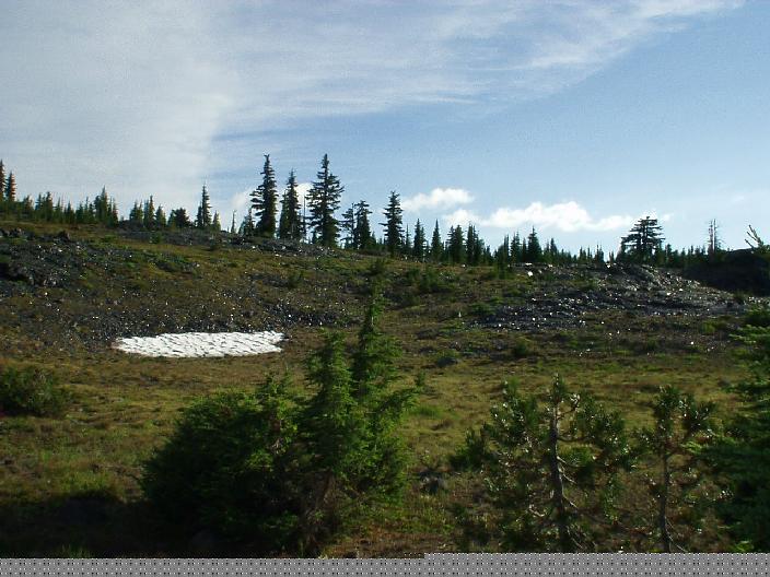
 **** Blue Cliffs
Overlook Trail (John Day Nat. Monument, Sheep Rock Unit, OR) :
This hike starts out from a trailhead along highway 19. The trail travels
along ancient blue cliffs made up of dried clay with stones embedded in
it. Various strata of the cliff face have different colors. The dry and
dusty trail winds along the Juniper pines and high-desert shrubbery as it
ascends up to the top of a neighboring hill with the overlook. Numerous
expansive views of the Picture Gorge carved out by the John Day river and
the badly eroded blue cliffs which harbor a plethora of fossils. There are
great views of stark volcanic cliffs with columns of volcanic basalt as
well as rolling hills dotted with juniper. The whole thing reminded me a
lot of the Painted Desert/Petrified Forest area in northern Arizona. (Done
5/29/00 3.5 mile, 600 ft)
**** Blue Cliffs
Overlook Trail (John Day Nat. Monument, Sheep Rock Unit, OR) :
This hike starts out from a trailhead along highway 19. The trail travels
along ancient blue cliffs made up of dried clay with stones embedded in
it. Various strata of the cliff face have different colors. The dry and
dusty trail winds along the Juniper pines and high-desert shrubbery as it
ascends up to the top of a neighboring hill with the overlook. Numerous
expansive views of the Picture Gorge carved out by the John Day river and
the badly eroded blue cliffs which harbor a plethora of fossils. There are
great views of stark volcanic cliffs with columns of volcanic basalt as
well as rolling hills dotted with juniper. The whole thing reminded me a
lot of the Painted Desert/Petrified Forest area in northern Arizona. (Done
5/29/00 3.5 mile, 600 ft)I also checked out the Painted hills unit of John Day Nat. Mon. which has a couple of 1 milers with excellent views of the namesake hills with vividly colored red/black/yellow stripes. The Clarno unit is much smaller and 40 miles up the windy road from Sheep Rock. It had some reddish rock spires (palisades) that look like something out of Arches Nat. Park(Utah), except these are not red sandstone but volcanic ash with a lot of stones embedded in it.
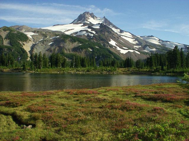
*** Pamelia Lake (Mt.
Jefferson wilderness, near Detroit, OR) : This hike is highly ranked
in various books but I found it somewhat mediocre. No doubt the foul
weather had something to do with it. Hike starts out in the lush forest
along Pamelia creek. Creek is pretty with mossy rocks and whatnot. Moss
covered forest floor is somewhat reminiscent of Ramona creek near Hood.
After 2 miles you come out of the forest on to the lake which has lots of
dead logs piled on the shore and several tree skeletons sticking out of
the water. Grizzly peak looms nearby. You actually need a permit from Detroit
ranger station just to hike this trail, of course they want the trail park
pass here as well.The second time I did this hike the weather was much nicer. Along the trail I met a ranger who checked the special permit and also warned about two "wild" dogs who had bitten a camper and messed with other dogs. Pamelia lake had shriveled down to a small pond size. Vast stretches of cracked and muddy lake bed lay exposed. Mt. Jefferson was visible from the shore of the lake and it looked pretty bare as well. I tried to find the trail to Grizzly Peak but instead wandered on to the Hunts Creek trail. This was not too bad since this section of the trail is quite pretty. It circles to the far side of the lake, crossing several streams and a couple of waterfalls in the process. On the way back I ran into the afore-mentioned wild dogs and their owner -- a backpacking woman headed back to the trailhead. The dogs looked like a pair of tough thugs and I was somewhat concerned about a dog fight erupting between my dog and them. Diamir (my dog) lost no time in checking them out and then proceeded to butt-fuck them before they knew what had hit them. The backpacking woman who owned the dogs was not amused, but was somewhat mollified because she liked my dogs looks. I could scarcely hide my mirth since I had built a fearful image of these pooches from the ranger's description. Again nice hike but somewhat overrated in various hiking books. (4 miles, 200 ft, done 9/2/00; 6 miles, 300 ft, done 9/23/01). View of Jefferson from Pamelia Lake
**** Tam McArthur Rim
(Sisters Wilderness, 17 miles from Sisters, OR) This hike is quite
pretty. The views would have been stunning in clear weather but
unfortunately no such luck was to be had on Labor day weekend 2000. It
snowed and hailed intermittently in the Driftwood campground which is the
starting point for this hike. The trail starts out at the 6000 ft.
elevation and is mostly a gentle climb. It only climbs steeply for short
distances a couple of times and then levels out on a plateau with nice
views down to the deep emerald Driftwood and 3 creek lakes. Broken Top's
jagged rim is visible to the left. Horseshit liberally litters the trail
all the way to the top. The rim is pretty sheer 500 ft drop-off with snowfields
at its base. The trail continues along the rim towards Broken Top. Weather
was pretty miserable and clouds totally engulfed the rim just as I got
there. It felt like snow was falling around me rather than coming from
above. Found the tent sagging under 1/4 inch of snow on my return. (8
miles, 1200 ft, done 9/3/00).
Finally redid this hike in the summer of 04. It is a very scenic hike and lives up to its high rating in the guidebook. The panoramic view from the rim was pretty nice. Marci, Nick and I did this hike as part of a weekend trip. Afterwards we continued along the rim towards Broken Top. The trail was full of views of volcanic features like cinder cones and lava bombs. It seemed to follow an old jeep road to the first view point and then meandered along an open plateau before going beside a snowfield to get to a second view point below what appeared to be a red cinder cone. We went up the side of this cinder cone which turned out be not a cinder cone at all but the edge of a ridge. The trail continued along this ridge until coming to a cliff where it degenerated into a climbers path. Very nice expansive views of the entire 3 sisters area. It was getting pretty dark by this time anyway so we turned back. It was considerably easier going down. I took a short-cut down from the "cinder cone" on what appeared to be a permanent snowfield.The campgrounds by the lake were full so we had to go back to a horse camp a few miles down the road and camp in miserable conditions. (8 miles, 1200 ft, done 9/3/00, done 8/7/04).
 ****** Obsidian Trail
(22 miles south of Sisters, OR) A gem of a hike -- this trail is
easily among my top 5 favorites in the Northwest. It is so popular that
the forest service limits the number of people who can hike it. Luckily I
was able to get a pass for it from the Detroit Ranger Office. The
trailhead is very weird with little pull-outs that look like a campground.
There is a friendly old forest service volunteer who mans the trail head
all day on weekends. The trail starts out in dense forest right from the
get-go. It angles up at a moderate slope and is wide and well-graded. Its
a long monotonous 2 hours (3 miles) before any views are to be had. The
trail suddenly breaks out of forest and ascends into a vast lava field
with Middle Sister looming in the distance. The contrast between the black
lava chunks and the green trees trying to establish a foothold in this
barren waste is very striking. The trail winds among the lava for a short
distance and in 15 minutes comes to a delightful meadow with a stream
running through it. Wildflowers bloom profusely and camping is prohibited.
The trail forks shortly after crossing this meadow and reentering the
trees. I took the right fork towards Linton Meadows. The pace is a steady
uphill. Soon the trail again comes out into a breathtakingly beautiful
meadow with a burbling stream running through it. All the usual alpine
meadow suspects were in full bloom here. Little blue and yellow
butterflies flitted around completing the impression that I had entered a
little slice of paradise. The ground had glints of obsidian chips which
are little glassy black volcanic stones. As I was reaching the edge of the
meadow , the dog suddenly darted off trail to a boulder and I could hear
loud and furious hissing emanating from behind the rocks. I resisted the
temptation to look behind the boulder for the fear that whatever was
behind that rock might lunge at me. It sounded like a feline hiss so it
might have been a cougar or a Manx. After this the trail comes into yet
another beautiful meadow. The profusion of obsidian chips increases with
each meadow and the combination of the flowers and glinting obsidian is
breathtakingly beautiful. The trail reenters the forest, the trees become
more massive during this stretch. Soon the trail crossed Obsidian Creek
and junctioned with PCT. To make this a loop I headed left on PCT. Within
a short distance beautiful Obsidian Falls came into view. The temptation
to go stand under it was high but time was running short. Shortly
thereafter the trail emerged above timberline at a spot near the top of
the waterfall. Camping is strictly prohibited in this spot. At this point
the trail enters a heavenly section of small lakes shimmering among
glittering expanses of obsidian and an abundance of wildflowers. High
sheer cliffs flank the trail on the right side and Middle sister summit
towers above it. The glittering ground makes you feel like you are walking
in a field of jewels. The little lakes are shallow, clear and beckon the
weary hiker for a dip. This section of the PCT will be etched in my mind
forever. At the end of this section is a great viewpoint with Mt.
Washington, Three Finger Jack and Mt. Jefferson all lined up. This trail
kept surprising me with one stupendous view after another just when I
began thinking it couldn't get any better. After the viewpoint the trail
quickly descended to Sunshine meadow with pretty Glacier Creek running
through a profusion of flowers. The banks of the creek were so inviting
that I stretched out there and munched on some snacks while absorbing the
pretty scenery around me. At this point the Glacier Creek trail headed
down from PCT back to the Obsidian trail. It took me only 20 minutes to
reach the lower meadow and lava fields. The final stretch to the trailhead
through the trees was a tiring and monotonous slog. Its a long trail but
the payoff in views more than justifies this section (12 miles, 2000 ft,
Done 8/5/01).
Captain's log supplemental: I redid this hike as a backpack in Aug 2002. This time
the weather was much cooler and a forest fire in Black Butte area provided additional protection
from the heat. The old ranger was here again just like last year. He let me park along the road since the lot was full. He also informed me that it was dipping below freezing at night in the parking area. Consequently we decided to take the heavier sleeping bag. The flowers and trail were spectacular as usual. Blooming beargrass on the lower trail made it more bearable as well (no pun intended). We set up camp in White Branch Creek meadow and did the loop the first day. Flowers and obsidian were as beautiful as ever though some of the colors lacked the vibrance they possess in bright sunshine. We also came across a bunch of naked women frolicking in one of the tarns. A couple of them scrambled out and clothed themsleves while the third continued to languish in the tarn. The crowds seemed pretty thin for a summer weekend but our late afternoon start may have had something to do with that. At night the stove refused to work so we had to make do by cooking on a small campfire. The second day I went up Glacier Creek to the Arrowhead lake area. The trail wanders up through the beautiful meadow to a stream crossing at a point where the stream is fairly wide. Then it ascends some rocky talus slopes to reach a plateau above the PCT. The climbers trail continue upward after reaching the upper plateau but there was a very faint side-trail to the lake. Its easy to miss it in the rocks and rubble. Arrowhead lake is shaped like a chevron or arrowhead which is probably how it got its name. I originally thought it might have had something to do with the obsidian arrowheads the indians used to craft from the obsidian found here. The views from here were quite good despite the fact that the mountains were socked in. The whole lower plateau with the tarns and obsidian cliffs was spread out like a map from my aerial vantage point. It was pretty chilly up here and I was glad I had camped in the lower meadow. After absorbing the scenery I headed on down. Wound up the camp and was out in a couple of hours. (done 8/3-4/02, 16 mi, 2500 ft)
****** Obsidian Trail
(22 miles south of Sisters, OR) A gem of a hike -- this trail is
easily among my top 5 favorites in the Northwest. It is so popular that
the forest service limits the number of people who can hike it. Luckily I
was able to get a pass for it from the Detroit Ranger Office. The
trailhead is very weird with little pull-outs that look like a campground.
There is a friendly old forest service volunteer who mans the trail head
all day on weekends. The trail starts out in dense forest right from the
get-go. It angles up at a moderate slope and is wide and well-graded. Its
a long monotonous 2 hours (3 miles) before any views are to be had. The
trail suddenly breaks out of forest and ascends into a vast lava field
with Middle Sister looming in the distance. The contrast between the black
lava chunks and the green trees trying to establish a foothold in this
barren waste is very striking. The trail winds among the lava for a short
distance and in 15 minutes comes to a delightful meadow with a stream
running through it. Wildflowers bloom profusely and camping is prohibited.
The trail forks shortly after crossing this meadow and reentering the
trees. I took the right fork towards Linton Meadows. The pace is a steady
uphill. Soon the trail again comes out into a breathtakingly beautiful
meadow with a burbling stream running through it. All the usual alpine
meadow suspects were in full bloom here. Little blue and yellow
butterflies flitted around completing the impression that I had entered a
little slice of paradise. The ground had glints of obsidian chips which
are little glassy black volcanic stones. As I was reaching the edge of the
meadow , the dog suddenly darted off trail to a boulder and I could hear
loud and furious hissing emanating from behind the rocks. I resisted the
temptation to look behind the boulder for the fear that whatever was
behind that rock might lunge at me. It sounded like a feline hiss so it
might have been a cougar or a Manx. After this the trail comes into yet
another beautiful meadow. The profusion of obsidian chips increases with
each meadow and the combination of the flowers and glinting obsidian is
breathtakingly beautiful. The trail reenters the forest, the trees become
more massive during this stretch. Soon the trail crossed Obsidian Creek
and junctioned with PCT. To make this a loop I headed left on PCT. Within
a short distance beautiful Obsidian Falls came into view. The temptation
to go stand under it was high but time was running short. Shortly
thereafter the trail emerged above timberline at a spot near the top of
the waterfall. Camping is strictly prohibited in this spot. At this point
the trail enters a heavenly section of small lakes shimmering among
glittering expanses of obsidian and an abundance of wildflowers. High
sheer cliffs flank the trail on the right side and Middle sister summit
towers above it. The glittering ground makes you feel like you are walking
in a field of jewels. The little lakes are shallow, clear and beckon the
weary hiker for a dip. This section of the PCT will be etched in my mind
forever. At the end of this section is a great viewpoint with Mt.
Washington, Three Finger Jack and Mt. Jefferson all lined up. This trail
kept surprising me with one stupendous view after another just when I
began thinking it couldn't get any better. After the viewpoint the trail
quickly descended to Sunshine meadow with pretty Glacier Creek running
through a profusion of flowers. The banks of the creek were so inviting
that I stretched out there and munched on some snacks while absorbing the
pretty scenery around me. At this point the Glacier Creek trail headed
down from PCT back to the Obsidian trail. It took me only 20 minutes to
reach the lower meadow and lava fields. The final stretch to the trailhead
through the trees was a tiring and monotonous slog. Its a long trail but
the payoff in views more than justifies this section (12 miles, 2000 ft,
Done 8/5/01).
Captain's log supplemental: I redid this hike as a backpack in Aug 2002. This time
the weather was much cooler and a forest fire in Black Butte area provided additional protection
from the heat. The old ranger was here again just like last year. He let me park along the road since the lot was full. He also informed me that it was dipping below freezing at night in the parking area. Consequently we decided to take the heavier sleeping bag. The flowers and trail were spectacular as usual. Blooming beargrass on the lower trail made it more bearable as well (no pun intended). We set up camp in White Branch Creek meadow and did the loop the first day. Flowers and obsidian were as beautiful as ever though some of the colors lacked the vibrance they possess in bright sunshine. We also came across a bunch of naked women frolicking in one of the tarns. A couple of them scrambled out and clothed themsleves while the third continued to languish in the tarn. The crowds seemed pretty thin for a summer weekend but our late afternoon start may have had something to do with that. At night the stove refused to work so we had to make do by cooking on a small campfire. The second day I went up Glacier Creek to the Arrowhead lake area. The trail wanders up through the beautiful meadow to a stream crossing at a point where the stream is fairly wide. Then it ascends some rocky talus slopes to reach a plateau above the PCT. The climbers trail continue upward after reaching the upper plateau but there was a very faint side-trail to the lake. Its easy to miss it in the rocks and rubble. Arrowhead lake is shaped like a chevron or arrowhead which is probably how it got its name. I originally thought it might have had something to do with the obsidian arrowheads the indians used to craft from the obsidian found here. The views from here were quite good despite the fact that the mountains were socked in. The whole lower plateau with the tarns and obsidian cliffs was spread out like a map from my aerial vantage point. It was pretty chilly up here and I was glad I had camped in the lower meadow. After absorbing the scenery I headed on down. Wound up the camp and was out in a couple of hours. (done 8/3-4/02, 16 mi, 2500 ft)
View of PCT and obsidian plateau from Arrowhead Lake.
Glittering obsidian along PCT.
 ***** Moraine Lake/
South Sister (25 miles from Bend OR) This was a 3 day backpack
over Labor day weekend. The trailhead at Devil's Lake campground looked like
a zoo. It seemed like everybody was headed off in the same direction as
me. My suspicion was soon confirmed on reaching the wilderness boundary
with a sign proclaiming that the Moraine lake campsites were full. Very
frustrating when even backpacking doesn't ensure you a campsite. I pressed
ahead anyway. The trail was steep from the get go, and with a heavy pack
it was tough going. After about an hour and a half of trudging up this
trail through a fir forest, I came to a trail junction at the edge of Wickiup
Plains. The trail to Moraine Lake branched off to the right and I headed
down this. As usual I had gotten off to a late start and it was getting
pretty dark at this point. There was no point in going on to Moraine lake
since the place was full anyway. I quickly located a campsite in some
trees and pitched tent. Made sure the dog didn't lose his pack this time
like he did on my last backpack in Paradise Park. It was a beautiful night
with full moon. Both South Sister and Broken Top were clearly visible in
the moonlight. After a quick dinner of chili and chips, I lounged around
the campfire for a while and then hit the sack.
***** Moraine Lake/
South Sister (25 miles from Bend OR) This was a 3 day backpack
over Labor day weekend. The trailhead at Devil's Lake campground looked like
a zoo. It seemed like everybody was headed off in the same direction as
me. My suspicion was soon confirmed on reaching the wilderness boundary
with a sign proclaiming that the Moraine lake campsites were full. Very
frustrating when even backpacking doesn't ensure you a campsite. I pressed
ahead anyway. The trail was steep from the get go, and with a heavy pack
it was tough going. After about an hour and a half of trudging up this
trail through a fir forest, I came to a trail junction at the edge of Wickiup
Plains. The trail to Moraine Lake branched off to the right and I headed
down this. As usual I had gotten off to a late start and it was getting
pretty dark at this point. There was no point in going on to Moraine lake
since the place was full anyway. I quickly located a campsite in some
trees and pitched tent. Made sure the dog didn't lose his pack this time
like he did on my last backpack in Paradise Park. It was a beautiful night
with full moon. Both South Sister and Broken Top were clearly visible in
the moonlight. After a quick dinner of chili and chips, I lounged around
the campfire for a while and then hit the sack.Next morning I packed up and quickly left for Moraine lake in the hope of snagging a spot that might have fallen vacant. I met a couple of backpacking parties who had left Moraine lake in the morning so chances were bright that I might actually find something. The trail is broad and sandy in this area, it passed though a couple of depressions that look like dry lake beds. Trees are sparse and scattered around in clumps. I soon reached Moraine Lake and found an empty site. The designated sites have a little wooden post with a triangle cut into it. I filtered some water and cooked lunch of rice and turkey. Then I saddled up the pooch and we headed out towards the South Sister summit. The trail continues up a flat expanse on the far side of the lake and then ascends steeply up a loose ashy slope. The last bit of this trail was somewhat tricky and required clambering over some rocks to get to the main trail to South Sister summit. After this the trail meandered through dwindling trees and then entered the upper slopes of South Sister. There were literally hundreds of people thronging this trail. The dust being kicked up by their passage was phenomenal. Views downhill clearly showed the passage of the trail across the Wickiup Plain and up the mountain. Various Cascade lakes shimmered in the distance and Mt. Bachelor and Broken Top loomed nearby. The trail kept getting progressively steeper and dustier. The ash trail surface made for hard uphill. The wind was very strong at higher elevations and kept kicking grit into my face. Finally after an interminable slog I came to the foot of Lewis Glacier at the 9000 ft level. There was little lake full of silty gray glacial melt at the foot of the glacier. This seemed like a good turning point for several reasons. Firstly, both the dog and I were pushing our physical limits. Secondly, the red cinder cone surface in the final stretch was going to be very hard on the dog's feet. Finally , the late morning start had done me in as usual. After a quick lunch and a lingering look at the summit I turned back. The way back was much easier going. The feet just sank into the ash and it provided a natural brake and cushion. I rapidly plunge-stepped my way down to timberline. This is where I first encountered "Ranger John". I never did learn his name but I just dubbed him that. He was way too intrusive and chatty, sermonizing about all kinds of basic trail etiquette and proclaiming that all soiled toilet paper be packed out. Apparently burning a little bit of TP was too much pollution in his book. After tersely declining his offer of "baggies" for toilet paper I carried on and made it back to camp by sundown. Needless to say I was exhausted after this long day. After a quick dinner of Tuna helper I zonked out and slept soundly.
Next morning I woke up considerably refreshed. People were packing up and leaving around me and I finally felt like I had some privacy. However soon that illusion vanished as "Ranger John" reappeared. Apparently the zealous sonofabitch was camped out in the area and was "patrolling" the campsites to make sure everything was OK. He again launched into his "leave-no-trace" spiel and asked me to leash my dog. I was quite pissed at this officious asshole's intrusion into my campsite and rebuffed his efforts at chit-chat with frosty silence and terse one syllable replies. He soon left and I saw him scurrying around with a garbage bag, checking for god-knows-what. After cooking a leisurely lunch and napping for a while I packed up and left. On my way out I again saw "Ranger John" of the sphincter police. He was haranguing a couple of backpackers by the lake with his standard sermon. By this time I had had enough of this repulsive fellow so I decided not to tarry by the lake and left immediately. The trail back went quickly. There was a worrying interlude where the dog encountered 3 horses on the trail and freaked them out. Since horses are forbidden on this trail I can only imagine what the anal ranger had to say when he saw those horses. He would probably shit a brick and then "bag" it. I was down at the parking lot in about 1.5 hours. The usual Forest Service postcards in the windshield were accompanied by a strictly worded "warning notice" about being present on federal land without approval. Oh well, time for another letter to the congress people about the trail park pass. (9 mi., 3500 ft, Done 9/01/01-9/03/01).
***** Twin Pillars (Mill Creek Wilderness near Prineville, OR): A good
Fall or Spring
hike when the mountains are shut out by snow. I decided to do one last
backpack before winter arrived in earnest. Since the John Day area was
supposed to be relatively dry I headed in that general direction. Originally I was hoping to hit Black Canyon or Strawberry Mountain Wilderness but because of a late puttering start I found myself rapidly running out of daylight. Mill Creek rapidly became the only practicable choice. The
trail started from Wildcat campground which is reached after 10 miles on
Mill Creek Rd. Hunting season had begun and there were several hunters and
horses in evidence at the campground. One guy was camped out with a huge
RV and what appeared to be a smoke house. A severed elk head adorned his
campsite. The trail started just before the campground on the side of the
stream that is away from the campground. It was nice and flat as it
paralleled Mill Creek through a very picturesque valley with pine and fir
trees. There are numerous creek crossings which have no bridges and
require some rock-hopping. A hiking couple I ran encountered told me that
hunters had warned them to make themselves scarce around dusk to avoid
getting shot. In light of this info I decided to pitch camp before it got
dark. I found a nice spot by the stream at the base of a big Ponderosa
pine. Starting a campfire was pretty easy since things were still pretty
dry. I didn't hear any major shooting that night. It sprinkled a little
bit now and then but nothing compared to the rain I had driven though to
get here.Next morning the weather was even nicer with a few patches of blue puncturing the overcast sky. I followed the trail for about 2 miles along the valley beside the stream. The trail basically stayed in the valley but did climb up on the true left bank periodically. There was an abundance of streamside campsites all along this section of the trail. There were 3 bridgeless stream crossings as well which were fairly easy rock hopping affairs since water level was pretty low. Soon I came to a junction with Belknap trail. The twin pillars are 2 miles from this junction. At about this point I noticed signs of a pretty recent fire which greatly marred the beauty of this part of the trail. I later found out that this was the biggest fire in Oregon in 2000. The trail soon left the stream and started climbing in earnest up a hill with badly burnt pine trees. At this point I decide to break for lunch before leaving the stream. I spent an hour trying to warm water on the stove for my mac&cheese lunch but for some reason it was slow as molasses. Finally I gave up and just built a little fire to heat the water. Wasted a good hour of sunlight in this effort. Trail dipped to cross a stream and then switchbacked up to the ridgetop and the base of the twin pillars. There are nice views from here of the entire Mill Creek wilderness including the charred hilltops ravaged by last year's fire. The pillars were interesting 200 ft volcanic plugs that stuck out from the forest. There was no maintained trail to the base as far as I could see but I scrambled up the hill side to the saddle at the base of the pillars. There was quite a bit of crumbly rock at the base. The rock of the pillars has a green tint because of algae growing on it. Some bright orange algae adds interesting highlights to the sheer face. I had to be very careful going down to the trail since it is somewhat treacherous footing. The way back went very quickly. I had foolishly left my flashlight at the campsite so I was hurrying to get back by dark. There were a few anxious moments towards the end when it got really dark and I had to make the last stream crossing in the dark and then find my tent. I had to abandon my original plan of packing out that evening and spend another night here. Not an altogether unwelcome turn of events, since the sky cleared and a bright moon lit up the entire valley.
Next morning it started raining at 7:30 am and it was still raining at noon when I finally steeled myself to emerge from the warmth of my sleeping bag, pack up my belongings and the soggy tent, and leave. It was really nice hike both for views and solitude. Too bad I didn't do it before last year's fire. On the way back I went up a side road and followed the trail to Stein's Pillar ( a striking rock formation) for a while along the ridge top. Its a nice leg stretcher in a fragrant pine and juniper forest with expansive views of the valley. (12 miles, 1000 ft. Done 10/27-10/29/01)
***** Jefferson Park (Mt. Jefferson) : A classic hike that easily ranks among the best I have done in Oregon. The dirt road to the trailhead seemed easy enough but I discovered I had a flat tire about 2 miles into the 7.5 mile Whitewater Road. After fixing the flat I made my way gingerly up the road, hoping and praying that I wouldn't pop a second tire. At the trailhead I encountered a guy who helped me put my tire troubles in perspective.He wanted a ride down to fetch a towtruck because a teenage driver in his party had rolled his SUV down a 70 degree slope off the parking lot. While my heart bled profusely for this unfortunate person, I was unwilling to risk a second flat by going down to the trailhead again. Secondly it was getting late and I wanted to be on the trail. A couple that had arrived a few minutes before me also seemed to feel the same way. Fortunately at this moment a returning group of backpackers emerged at the trailhead and gladly offered to take the standed driver down to fetch a tow truck. The hike started out in mature fir and hemlock forest. It was a really hot day and the shade provided welcome relief. The trail executed a sereies of long switchbacks. The trees transitioned to scraggly looking Pacific Fir. After about a couple of miles the trail started to break out of the trees into glaring sunlight. This portion of the trail was really hot and dusty and both me and the dog took frequent stops in the shade. After a little more slogging the views opened up nicely towards Jefferson and river valley. The trail also eased off a little bit after reaching a saddle and then started heading down at a gentle angle. This section had some great views of Jefferson with the sizeable Jefferson Park Glacier tumbling down its slopes. We reached Whitewater creek after about 3 hours and took a breather there. The dog loaded up on water and I filtered some as well. The hiking book (Judd and Nelson) had seemed to suggest that the initial portion of this trail would run along Sentinel Creek so I had imagined an abundant supply of water for self and dog. The reality is that the first 4 miles of this trail are virtually waterless except for one brief moment when trail comes close to Sentinel Creek during the inital switchbacks.
After the creek crossing the trail ambled up to meet PCT. Meadows started appearing and the trail follwed a pretty stream for a sort distance before reaching Jefferson Park. The Park, as advertised, was a very beautiful plateau studded with lakes and shallow tarns and profusely covered with flowers. I dropped my pack and explored a little to find a nice camp site with lake and mountain views if possible. Russel Lake seemed to be a nice one but all the designated sites were taken. After circling Russel Lake and finding nothing, I headed back towards Scout Lake and found a great spot between Scout and Bays Lakes with an awesome view of the mountain. The mosquitoes were particulary brutal here and I got bitten numerous times as I frantically tried to filter water and swat at the pesky buggers at the same time. Finally it got so bad that I hastily set up my tent and retreated into its sanctum to avoid the blood-thirsty hordes. About a dozen mosquitoes followed me into the tent and I spent about 15 minutes hunting them down and executing them. At this point I was just about ready to call it a day and go to sleep hungry rather then contend with the mosquitoes. However I noticed that the mosuito activity decreased substantially after twilight ended. So I got out, cooked some dinner (Lipton rice and a can of Costco chicken) and admired the brilliant starry skies for a couple of hours. I was hoping to catch the Perseid meteor shower but saw only a few artifcial sattelites arcing across the sky. The new moon made a brief appearance and its reflection in the lake was quite a bewitching sight. Hit the sack around 11 pm.
A strong breeze started blowing in the early hours of the morning. It helped decrease the mosquito activity somewhat. I got up around 8:30 and made myself some breakfast (Farmhouse Pastaroni). Filtered some more water using the faltering sweetwater filter. Reaming it with the brush seems to be becoming ineffectual. On the plus side it sprays enough water that one can get a shower and filter water at the same time. Then I did a second loop of the lakes. The views were particulary stunning in a meadow by Russel Lake. Mt. Jefferson twered above the lake with Whitewater, Jeff Park and Russel Glaciers (Left to Right) visible. I filtered some water here from a stream that feeds into the lake. Noticed a lot of snail-things were attached to almost every rock in the stream. Also noticed a few small fish darting around in the stream. All the campistes around the lake were vacant today and I had the entire place to myself. I followed a side trail past Russel Lake in the hopes that it might be the climbers trail heading up the mountain. However it petered out at yet another lake. Enroute we startled a family of 4-5 ptarmigans who rocketed out of the grass and startled the bejeezus out of the dog. Returned from my jaunt by 1:30 pm. Broke up camp and hit the trail by 2:20 pm. The trail back went fairly quickly. Made a couple of stops to filter water. The uphill section went a lot easier than I expected and soon I was barrelling down the last section down to trailhead. Reached the parking lot by 5:10 pm. Mercifully the truck made it down without any further mishaps.
Topo Map of Jefferson Park
Russel Lake and Mt. Jefferson.
Scout Lake and Park Butte.
Along the trail.
(14 miles, 2000 ft, done 8/12-13/2002)
***** Chambers Lakes (Three Sisters Wilderness, OR) : An excellent backpack with great weather and good timing. Since getting laid off I had been itching for a mid-week backpack and this seemed like a good option. My friend Mark and I left Portland and reached the Pole Creek Trail Head by 2 pm. There were only 4 cars parked at the trailhead boding well for our prospects of snagging a premium camping site. We quickly ate some lunch and then hit the trail. It was really hot in the mid-day sun and we found ourselves struggling with the heavy packs. The trail was very dusty as it started out in scraggly looking pine forest with a few mature ponderosa pines. I realized 10 minutes into the hike that I had forgotten the water bag in the truck but decided against going back just to fetch it. After 1.5 hours we came to the first creek crossing. There was a guy camping there and it was the trail junction for Green Lakes. We took the right fork here for Camp Lake. After about another 1.5 hours we reached a second creek. At this point we decided we had had enough and set up camp next to this creek. The mosquiotes here were pretty bad and I soon had to don the headnet and gloves to protect myself from their merciless attack. Even though I wasn't feeling particularly hungry I cooked up some ramen noodles. We then lit a camp fire in the hope that the smoke from it would keep the mosquitoes at bay. Surprisingly this strategy worked pretty well and we spent a couple of hours keeping the fire going before putting it out thoroughly. Spent 15 minutes inflating my air mattress but the damn thing deflated in the middle of the night. Good thing I had brought my trusty sleeping pad instead of relying exclusively on the air mattress.
Woken at 8:30 by Mark who was itching to get going. Quickly cooked up some Lipton rice before breaking camp and continuing on the trail. This next stretch went pretty quickly but the mosquitoes kept pestering us. Finally I had to put on my net again. We soon came to a silt-laden glacial stream. Here we encountered a climbing party with many of them wearing head nets as well. They told us the mosquitoes were pretty bad at Camp Lake as well. The views improved considerably as the trail forked once again with a small side-trail going off to the left to DeMaris Lake. As the trail climbed a series of switchbacks we got increasingly better views of North and Middle sisters. Soon we came to a high plateau with great views of the afore-mentioned sisters as well as Broken Top. At this point I decided to go down to a small lake and filter some water while Mark pressed on. The dog followed Mark. I continued ata leisurely pace after filtering a couple of litres of water. The views were stupendous with beautiful blue skies and North and Middle Sisters towering above the trail. There was an awesome hanging glacier on Middle Sister. The trail was confusing here with frequent snowfields obscuring it in places. I lost the trail once and had to backtrack a little to find it again. The most difficult part was a big snow field with a very steep 10 foot drop on the other side of it. I tried to skirt it and descend on some rocks but lost my footing and fell in the snow. Luckily I was able to right myself before I slid down the steep slope. Then I carefully went down on the rocks and quickly reached Camp Lake. The lake was extremely scenic with almost turqoise waters and snow calving icebregs into it at the far end. South Sister dominated the back ground and seemed close enough to touch. There was nobody else there when we showed up and we had the entire palce to oursleves. Mark was already there and had scouted out a camp site a little bit above the lake in a clump of trees. We quickly set up camp and then just chilled in our respective tents for an hour or so. After that we circled the lake. I ventured out on the snow and took some close up shots of the snow that was breaking off in huge chunks and falling into the shallow lake. We saw some more camp sites one of which was particularly nice but it was too late to move there plus we had access to running water whereas this site would have had to rely on the lake for water supply. On the far end of the lake was an outlet where water gushed out and tunneled under a snowfield on its way down the mountain. You could see middle sister from the other side of the lake. We spent the rest of the evening cooking, filtering water and taking it easy. I cooked up some lentils that I had brought with me but the experiment was not very successful because they took a long time to cook and also burnt and stuck to the bottom of my cooking pot. I also spilled some as I was ladling it out but the dog helpfully licked up all the spill. Another party showed up in the evening and quickly grabbed the spot I had liked so much on my walk around the lake. Hit the sack after washing the dishes and washing up the lake. Throughout the evening I could hear large splashes as more snow calved into the lake. Frequent rockfall avalanches could be heard rumbling on South Sister.
Woke next morning around 7:30 to clear skies and bright sunshine. Cooked up some Lipton rice with canned chicken for breakfast. Left half of it in the snowpatch near our camp. We were ready to explore the Chambers Lakes by 9 am. The trail to Chambers Lakes was visible in the scree slope behind the lake and we scrambled up the loose rock to get to it. It was tough going and I was glad we wereto be carrying a light daypack instead of the full pack. The trail was little more than a goat trail and we came across a huge pile of shit on it that seemed like bear or cougar and it was very fresh. At first I suspected it was my dog's doing but Mark assured me that the dog had nothing to do with it. The rocky trail petered out soon and we hike cross-country across a boulder field to get to the steep snowfield that led to the ridgetop. The ridge was covered with stunted pine trees that blocked most of the access to the ridge and we had to bush whack a little to get through. We rested a bit and I got some of the small rocks that had worked their way into my boots. Then we proceeded up the ridge by kick-stepping up some snowfields as well as wending our way through thickets of krummholz. Soon we could see the first Chambers lake nestled in a basin below us. Its blue waters made it look like a jewel. The setting was magnificent with South and Middle Sisters standing over the lake like guardians. I felt the pleasant waves of alpine nirvana sweep over me as I soaked up the vista. The rocky volcanic cliffs surrounding the lake were also very striking and seemed scoured by ancient glaciers. There was plenty of snow lingering in the basin and many snowmelt streams fed this lake which had no outlet. The whole place was totally deserted and it was easy to imagine that we were the first people to set eyes upon it. We gradually walked around the lake and onto the steep snowfield that led to the ridge on the far side of the lake. Once we reached the ridge we discovered a muddy lake being fed from some glacial stream coming from South Sister. The contrast between the two lakes was amazing and we were stunned by all the beauty surrounding us. No pictures can do this place justice. After lingering here for a while we returned the way we had come. On the way back I decided to try descending the snow field to Camp Lake instead of wearing my ankles out on the scree slope. Mark was a little hesitant about it but when he saw me rapidly plunge stepping down the snow he followed suit. It tooks us all of 5 minutes to get down to Camp Lake while it had taken us 45 minutes to climb up on the talus slope. We were back in camp by 1:15 and debated packing up and going home but I suggested that we go check out the two remaining Chambers Lakes that were on the map. Mark had never been to those lakes either and readily agreed. We rested ni camp for an hour while my boots dried. Then we set out cross country to the remaniing Chambers Lakes. Mark did a good job of navigating and we climbed up one of the valleys that surrounded Camp Lake. It was tough going and I felt pretty tired after the morning hike but managed to drag my ass up several snow fields. Then suddenly we were at the lake. I thought the other Chambers Lakes were pretty but this place just blew me away. The lake was absollutely flush with the ground instead of nestling in a basin. A couple of ice bergs lazily floated near the outlet where a stream gushed down the mountain. A curving shelf of ice arced across the lake and almost reached the shore near to us. South Sister was so close that it nearly blocked out the entire sky on one side of the lake. The waters were an icy blue and the lake was much deeper than the other lakes we had seen so far. When we circled over to the right our jaws dropped open with amazement. There was the last Chambers Lake deep below us in a hollow. This lake was almost entirely frozen except for a few cracks where the icy blue water was visible. A few big icebregs floated in one corner that had melted out. North and Middle Sister provided the backdrop on one side and South Sister on the other. We were extremely glad and congratulated ourselves for coming up here tp explore instead of packing out in the afternoon. We circled around the frozen lake and discovered yet another albeit smaller lake behind this frozen lake. This last lake was an unexpected bonus and the phrase "my cup runneth over" felt very apt. This lake's waters were greenish in color and ice had a brownish tinge because the stream that fed this lake was coming a glacier on South Sister and had high silt content. I crossed over on some dicey looking snow to the far side of this lake and took some shots of the lake with North and Middle Sister behind it. It truly felt like I was in the throne room of Oregon's mountain gods (or rather godesses). I don't think I have done a prettier hike in Oregon in a long time. No doubt the time of the year and the solitude made this place even more impressive but whatever the reason this hike suddenly shot up to my top 3 hikes in Oregon list. On the way back I tested the ice shelf on lake 3 with my pole and it felt pretty sturdy. However when I put my foot on the ice, it gave way and fairly large size chunk of ice broke off and formed an iceberg that lazily drifted in the lake. I managed to jump back with thorughly wetting my boot. We lingered in this hallowed place for as long as we could before returning to camp. This day was our reward for hauling thos heavy packs 7 miles in to Camp Lake. It didn't feel like a lot of peopl came up to these lakes and that made it all the more special. Mark found a nice digital camera just lying on the ground near camp lake and went to find its owner while I made my way back to camp. The snow around camp lake was melting at a prodigious rate and the place where we had crossed yesterday on our lake circuit was now badly crevassed and ready to slide into the lake. I still managed to make it across on the snow but stayed as far away from the water as possible. Made some past alfredo for dinner. Mark had complained that the dog kept him up last night so I tied him up with a rope to keep him away from Mark's tent. I also realized that I was missing my neoprene knee brace. I went looking for it and found it near the place where the trail came to Camp Lake. We both retired to our tents around 10 but for some reason I couldn't go to sleep till midnight. I also heard rocks falling as some animal came down the same rocky trail we had gone up in the morning. I thought about that large animal shit I had seen on the trail and hoped this animal would stay away from our camp.
Woke up next morning around 8a am. Didn't feel like cooking anything. Backpacking fatigue has set in and I just wanted to get home and take a shower. Quickly packed up and left camp lake by 9:45 am. It was Saturday and hordes of people were laready streaming towards Camp Lake. I was really glad that we had done this trip mid-week. I guess unemployment does have its advantages. The return trip was going well and we were in the last mile when disaster struck. I was racing ahead in my hurry to get out when Mark hollered at me to wait up. He said my dog was limping and refusing to continue down the trail. I rushed back and found the dog was indeed limping and seemed to be suffering from heat exhaustion. We had passed 3 creeks along the way that were reasonably spaced apart and I thought the dog would be adequately hydrated but I had not realized that the past few days hiking over lava rock had hurt the pooch's paws. Now the hot dusty trail was burning his feet and he hobbled pitifully. My heart sank at this sight. I quickly got his pack off and Mark and I squeezed most of the contents from his pack into our packs. Diamir felt better after his pack was off but he still limped and would stop frequently in shady spots to rest. I gave him the rest of my water which he consumed gratefully. I gave Mark the car keys and told him to go down while I slowly made my way down the trail. I recalled how I had seen many people hiking with their dogs who had booties on the paws and bitterly regretted not getting booties for Diamir. Then I got the idea to put a pair of my socks on his front paws that seemed to be hurting the most. They looked copical but they did help him walk better on the hot ash that formed the trail surface here. But the socks slipped off in just a few steps. I was despairing t this point. The mid-day heat was sapping my energy and the dog seemed even worse off than I was. I gave him the rest of my water and also took a strap off my pack to tie the socks in place on his legs. I told the dog to stay put and rushed off down the trail to see how far I was from the trailhead. Soon Inrealized that it was too far away and turned back. I felt like Abraham's wife Hajira who had to run back and forth in the Arabian desert looking for water for her infant son Ismail. The situation looked extremely grim and I was wondering how the hell I was going to carry a 110 lb dog out to the car. Fortunately the dog was not as tired as I thought and managed to limp his way down to trailhead. A quick cup of coffee at Sisters Coffee company and then the long drive back home. (20 miles, 7/16/2003-7/19/2003)
***** Green Lakes (3 Sisters Wilderness): I did this over the July 4th weekend and was expecting to see tons of people but there weren't that many people on the trail. The trail started out along the appropriately named Fall Creek. For the first couple of miles the trail gently climbed along the creek with dozens of small and large waterfalls. There was still plenty of snow on the ground and made for relatively slow going in places as I had to climb up and down the snow banks. The trail finally broke out into a relatively flat area where the creek turned into delightful broad and shallow stream with some early flowers gracing its banks. I took a break here and consumed a luna bar. The trail crossed over the stream in two stages. First crossing was on stepping stones and second on a log bridge. Now the trail started climbing up more rapidly. The snow was thick and covered with tree debris. I tried to folow the boot prints as best I could but did lose the trail a couple of times. Finally the trail corssed a couple of side streams and entered a remarkable V-shaped valley with one side totally barren and littered with obsidian boulders and the other side forested and green. The trail continued over snow on the green side and finally topped out at the basin containing Green Lakes. Broken Top and South Sister loomed over the basin like guardians. The lake was still almost entirely frozen and the basin was mostly covered with snow as well. I had my lunch here and admired the view. My digital camera had been low on batteries ever since I started but I had managed to coax it along by turing the LCD off. However it gave out at this point and I had to dig out the SLR, which was the right thing anyway since it could do better justice to the scene with its wider angle lens. I spent half an hour soaking in the scenery and then returned the way I came. (8-9 miles, 1100 ft elevation gain, left at 10:30 am, returned 6 pm, Done 7/5/04) ***** Canyon Creek Meadows (Three Finger Jack): This hike starts out from a lake in the middle of forest devastated by the B&B complex fire that burnt a large swath of forest around TFJ in 2003. In fact I remembered seeing this fire from Gnarl Ridge on Mt. Hood in Aug 2003. The trail climbed to a trail junction. I took the shorter left branch since I was pressed for time having done the Metolius River hike in the morning. Nick and Marci had opted to stay at the lake so I didn't want to waste too much time. There were a few trees that appeared to have survived. Mt. Jefferson soon became visible through the burnt trees as the trail reached a ridge. This appeared to be the place where the fire stopped and soon thereafter the trail started going down in thick and alive forest and finally came out in the lower Canyon Creek meadow where it joined the other arm of the loop. There was a nice stream meandering through lush meadow here. The flowers seemed a little past their prime but very pretty setting nonetheless. The garishly colored face of TFJ loomed over the meadow and beckoned to me so I decided to hike up towards the upper meadow after filtering some soapy-looking water from the stream. There are abundant backpacking possibilities in this area. The trail paralleled the stream for a while and then climbed onto the upper meadow. This meadow had abundant lupine and other flowers. Views of TFJ were outstanding but the reds and oranges in the crags of three finger Jack were muted because of the afternoon light. The trail soon climbed above the meadow with some dramatic cliffs to the left and a large valley below me on the right side. The glacial outwash stream ran through this valley with abundant wildflowers. I continued on towards the obvious notch between two small moraines. The view from this notch was well worth the hike. There was a small green lake at the toe of the solitary glacier that exists on TFJ. The moraines had narrow trails going up with some exposure. I spent some time exploring this area, munching on trail mix and taking pictures. Initially it looked like the moraines fully enclosed the lake but there was a small gap on the right side from which the stream exited the glacial cirque. TFJ looked pretty formidable from this vantage point but people climb it from the other side which is a lot easier. I ran into very few people on this hike, the long drive to trail head no doubt filters out the less dedicated hikers. (7 miles, 1400 ft elevation gain, Done 8/8/04)  ***** Middle Sister North Ridge via Hayden Glacier (Pole Creek TH near Sisters): This was a Mazama climb with full roster of twelve climbers. We started out around 4 pm from Pole Creek TH after sorting and weighing gear. This was the first time I weighed a full backpack and it clocked in at 48 lbs. No doubt the climbing gear added a good extra 10 lbs to the pack. We started out briskly in sunny cloudless weather. The pack weight was bothering many of us but we managed to stumble along nonetheless. After about 2 hours of trail walking we came to the spot where trail crosses N. forsk squaw creek. This is where Mark and I had camped 2 years ago when we did Chambers Lakes. The climbers trail branched off and headed uphill parallel to the stream at this point. We followed the mostly clear trail all the way to timberline. At the end our route veered left and crossed the stream to a ridge with excellent views of the 3 sisters and Broken Top. It had taken us about 3 1/2 hours to get to this spot. The mosquitoes were pretty bad from the Green Lakes trail junction, all the way to timberline. Thankfully the strong wind on the ridge helped keep the pesky critters somewhat at bay. There were plenty of established campsites. I found a nice secluded spot with a fire-ring and quickly setup my tent. We were located between two streams but the one on the left was very silty and hard to reach. The one on the right was clear and lovely with heather and other flowers gracing its banks. I quickly filtered water and cooked dinner. Discovered much to my chagrin that I had forgotten the butter but the food turned out Ok even without it. I guess its one more thing I can leave behind from now on although the extra calories are probably needed considering the strenuous nature of backpacking. I ate dinner while soaking in the panoramic views and alpenglow and later moonlight on South Sister. I got a couple of nice slow-shutter shots of S. Sister. The climb leader announced his intention to leave camp at 7:30 am the next day for the climb.
 I spent a fitful night , just couldn't find a comfortable sleeping position. The wind was very strong but my sheltered campsite helped deflect most of it. I could hear it howling in the treetops though. Got up at 6 am with a crick in my neck and aching right shoulder. The day was clear and the views impressive in the morning light. I quickly snapped a few pictures as I waited for the water to boil. Even though I tried to get ready as fast as I could, I ended up being the last person to get ready. I hurriedly filtered water as the rest of the group waited impatiently and we set off around 8 am. The trail went by quickly as we ascended the lower moraines on a well-defined climbers trail. The views of n. Sister were particularly impressive as its crumbling garishly colored face loomed over us. There were a series of turquoise teardrop-shaped lakes below the moraine. Finally we reached the toe of Hayden Gl. and roped up after donning all the climbing gear we had hauled all this way. The glacier had some marginal crevasses opening up and we navigated them carefully to get to a snow-covered ridge. At this point the crampons came off because snow was too soft for them. This ridge got progressively narrower with steep dropoffs to Hayden on our left and even steeper drop-offs to N. Sister to our right. The right side had lots of crevasses so a fall here would have been ugly. Hayden Gl was mostly crevasse-free except for some fairly big ones right in the middle. I heaved a sigh of relief after clearing the ridge. We traversed across easy slopes to the saddle marking the N. Ridge. It was very clam in the shelter of the ridge and we took a break here and snacked. I went to the other side of ridge to take a leak and found the wind was quite strong (15mph+) on the ridge. The views of Renfrew gl. on the other side were pretty impressive. I could see all the way down to Arrowhead Lakes and the PCT running through the Obsidian/Sunshine area. Renfrew was much less crevassed than Hayden. After the break we ascended the crumbly, windy N. Ridge to about 9600 ft level where we encountered a steep 50 degree snowfield. It wasn't very long but it was unnervingly steep with considerable exposure. The leader took a half-hearted stab at climbing it and putting a picket in but gave up quickly. A couple of climbers who carefully down-climbed down this snowfield were also somewhat discouraging about conditions further up. Our group was composed mostly of green-horns fresh out of basic climb school (including myself), and no doubt that factored into our climb leader's decision to call it quits at this point. I was sorely disappointed and urged a little more effort at climbing it but there didn't seem to be a lot of takers for this idea. So there was little to do but respect the leader's call. We all felt pretty lousy about getting within 400 ft of summit but being denied the prize. We returned to the saddle and somberly munched on some more snacks. A raven alighted nearby and regarded us with beady contemptuous eyes for awhile before flying off to his mate. The descent down the ridge was quick and uneventful. The snow was soft enough for some plunge stepping and I felt much more secure because of it. There was some confusion towards the end as we lost our original tracks and ended up in some marginal crevasses but the leader came down and quickly steered us back to the moraine. We went past some fairly substantial crevasses as a result of this detour and I got some good closeup shots. We made quick work of the trail to camp and were back by 5 pm. It was totally calm in the evening in sharp contrast to yesterday. I went through the usual chores of water filtering and cooking dinner and then hit the sack and slept soundly.
Up at 6 am on another sunny day. Quickly broke camp and was ready to hit the trail by the appointed time of 9 am. We followed the climber trail back to main trail. For some reason the main trail looked a little different on the way down and I wondered if it was right trail. Apparently I wasn't the only one thinking along these lines as I saw Paul and another guy looking at a map and GPS to double check. We reached the Green Lakes junction around 10:30 am and then all doubts were removed. I was down to the cars by 11:30 am. We caravanned into Sisters and ate a well-deserved lunch at a nice Mexican place before heading back home. (15 miles, 4400 ft elevation gain, Done 7/15/05-7/17/05)
***** Smith Rock loop (Smith Rock State Park near Madras, OR): Decided to to do this since I had left Bend ealry in the morning and there was tons of time left. A very hot day with temps in the 90s. Rangers patrol the river section and overzealously ticket any off-leash dogs. I quickly descended to the bridge over the river which marked the beginning of the loop hike. After an initial brief jaunt along the river, I decided to reverse course and go counterclockwise so I could get the climb out the way while I was fresh. So Lasso and I started up the steep Misery Ridge trail. The views of the rock amphitheater and the Deschutes River were very impressive. The trail switchbacked 600 feet to the top of the rock and then meandered along the top to a very distinctive rock pillar called monkey face. Nice views of all the central cascade peaks from 3 Sisters to Mt. Hood. This whole area is extremely popular with rock climbers so I periodically came across various shirtless guys clambering around on rocks. It was an extremely hot day and I was chugging water like crazy. After reaching monkeyface the trail switchbacked down to the river and then paralleled the river back to trailhead. This is where the monkey face really takes on its simian resemblance. I dug out my new SLR 70-300mm lens and spent a good 10 mins just trying to switch lenses. There are a string of very striking rock formations all the way with the river providing a scenic backdrop. I let Lasso go down to the water and swim around a little bit to cool down whilke I kept a wary eye out for any rangers. This whole area looked like a chunk of some Utah national park that got lost and ended up in Oregon. Although the rock is lava tuff and not sandstone. I felt almost nauseous with the heat by the time I finished and almost had to drag myself up the last bit up to the road. (5 miles, 600 ft, 6/25/06)