 ** Short Horn Trail
(Mt. Adams) : Nice hike which starts out at the Morrison Creek CG. Trail climbs
along the (seasonal) creek for some distance before flattening out a bit in a meadow where it crosses a couple of streams . Then it climbs some more in relatively open forest before reaching timber line and
intersecting with "around-the-mountain trail". The trail starts
from the Morrison Creek campground which is reached after a bumpy ride up
a 5 mile dirt road. This same road climbs another 3 heavily rutted miles
to the South Climb trailhead. Hike has a few nice views of Adams when the
trees start thinning out near timber line. The first time I stopped at the first meadow because my recently sprained ankle was hurting too much. In 2005 I went up to Round-the-mountain and hikesdit a couple of miles north before backtracking the other direction and going to the place where I had found the trail after getting lost on the climb in July. The round-the-mountain trail was very scenic with fall foliage, numerous streams, one spring and great views of Adams and Avalanche Glacier. Views of St. Helens sporting a small steam plume and a hazy view of Hood rounded out this great fall hike. pic(6 miles to timberline, 1500 ft. 9/20/99 and (13 miles on 9/25/05))
** Short Horn Trail
(Mt. Adams) : Nice hike which starts out at the Morrison Creek CG. Trail climbs
along the (seasonal) creek for some distance before flattening out a bit in a meadow where it crosses a couple of streams . Then it climbs some more in relatively open forest before reaching timber line and
intersecting with "around-the-mountain trail". The trail starts
from the Morrison Creek campground which is reached after a bumpy ride up
a 5 mile dirt road. This same road climbs another 3 heavily rutted miles
to the South Climb trailhead. Hike has a few nice views of Adams when the
trees start thinning out near timber line. The first time I stopped at the first meadow because my recently sprained ankle was hurting too much. In 2005 I went up to Round-the-mountain and hikesdit a couple of miles north before backtracking the other direction and going to the place where I had found the trail after getting lost on the climb in July. The round-the-mountain trail was very scenic with fall foliage, numerous streams, one spring and great views of Adams and Avalanche Glacier. Views of St. Helens sporting a small steam plume and a hazy view of Hood rounded out this great fall hike. pic(6 miles to timberline, 1500 ft. 9/20/99 and (13 miles on 9/25/05))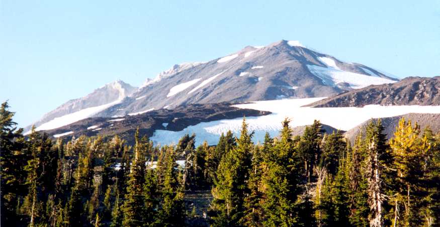 **** South climb Route,
Cold Springs trail 183 (Mt. Adams) : Nice hike which gradually
transitions into the mainly non-technical south climb up Suksdorf ridge on
Mt. Adams. The road to Cold Springs Campground and trailhead is one of the
worst I have driven and truly the road-from-hell. Hike has great views of
Hood (which looks remarkably similar to view of Jefferson from Hood) and
Helens. I hiked up to Crescent Glacier but was forced to turn back because
of painfully tight plastic mountaineering boots that I had rented for this
occasion. Moral of the story : feet swell on exertion so rent a larger
size than you usually wear . Second time around I was able to stagger
along with a sprained ankle for a while but turned back. Maybe there is a
jinx on this mountain for me. Even though I wrote these words 6 years ago they proved prophetically true when I actually did climb the mountain -- see trip report below. pic(7 miles, 1500
ft. ?, done 9/26/98 and again 9/20/99) ***** Killen Creek and
High Camp (Mt. Adams, North Side): An excellent hike with mountain
panoramas and meadows. The trailhead is 4 miles up the road from Takhlakh
lake. I did a little portion of the hike on Sat up to the first meadow and
Adams view. Based on the excellent view from the meadow I decided to
repeat the hike on Sunday and camped in the nearby Killen Creek
campground. The trail started out in thick forest of medium sized trees
(mostly Pacific Silver Fir). There were many flat sections interspersed
with some relatively steeper areas where trail steps up a series of
pseudo-stairs. After steepening perceptibly the trail broke out in a nice
meadow with stunning views of Adams Glacier ice-fall. It took me about 1
1/2 hour of fairly slow trudging to get to this point. The east branch of
Adams Creek runs through the meadow here and there were some nice
backpacking possibilities in the trees bordering the meadow. After
reaching this meadow the trail kept going up at a fairly gentle pace and
soon intersected PCT. I initially headed left but the trail seemed
uninteresting so I turned back after a lunch break and took the High Camp trail which branches
off to the right side at the intersection. This section was somewhat rough
and rocky. However the views of Rainier and Adams got better with each
step. There was one fairly steep section that required a little bit of
scrambling. After climbing this section I came to a really interesting
snowfield whose bottom was almost a geometrically precise straight line.
The trail continued up the rocky ridge at a gentler pace above this
snowfield. The last vestiges of trees and krummholz quickly fell away and
finally I was in the tundra above timberline. Views were sublime with Goat
Rocks, Rainier and St. Helens vying for attention. Mt. Adams loomed overhead
and provided a stunning backdrop to the meadow scenery. In early summer
these meadows would probably be even prettier with a profusion of
wildflowers. The North Cleaver route was quite obvious but looked pretty
daunting. Several stream beds meandered through the high meadow but most
were dry. Then I noticed one stream was actually in the process of
starting up as the snow melt rate increased in the midday sun. Kinda
fascinating to see a stream beginning. I filtered some water and soaked in
the scenery for an hour. This place would make for a bitchin' backpack.
Earlier hikers had also mentioned a pretty lake at the base of a
snowfield/glacier a little further up from high camp. However the route to
it is very rocky and since it was pretty late I decided against it. On the
return there was a slight hitch as I had senilely dropped my camera case
in the meadow somewhere as I was taking pictures and forgot to pick it up.
Since it contained film from my Sisters trip and other hikes, I was very
reluctant to leave it behind but daylight was running out fast. Finally
after doing a grid search for about 20 minutes I found the camera case. I
descended rapidly down the trail in the waning daylight. It got really
dark by the time I reached the lower meadows. Fortunately I had a small
flashlight and was able to make it down the last stretch in its feeble
light. The total trip down to the trailhead from high camp took about 2
hours. (9 miles, 2400 ft. Done 9/30/01)
**** South climb Route,
Cold Springs trail 183 (Mt. Adams) : Nice hike which gradually
transitions into the mainly non-technical south climb up Suksdorf ridge on
Mt. Adams. The road to Cold Springs Campground and trailhead is one of the
worst I have driven and truly the road-from-hell. Hike has great views of
Hood (which looks remarkably similar to view of Jefferson from Hood) and
Helens. I hiked up to Crescent Glacier but was forced to turn back because
of painfully tight plastic mountaineering boots that I had rented for this
occasion. Moral of the story : feet swell on exertion so rent a larger
size than you usually wear . Second time around I was able to stagger
along with a sprained ankle for a while but turned back. Maybe there is a
jinx on this mountain for me. Even though I wrote these words 6 years ago they proved prophetically true when I actually did climb the mountain -- see trip report below. pic(7 miles, 1500
ft. ?, done 9/26/98 and again 9/20/99) ***** Killen Creek and
High Camp (Mt. Adams, North Side): An excellent hike with mountain
panoramas and meadows. The trailhead is 4 miles up the road from Takhlakh
lake. I did a little portion of the hike on Sat up to the first meadow and
Adams view. Based on the excellent view from the meadow I decided to
repeat the hike on Sunday and camped in the nearby Killen Creek
campground. The trail started out in thick forest of medium sized trees
(mostly Pacific Silver Fir). There were many flat sections interspersed
with some relatively steeper areas where trail steps up a series of
pseudo-stairs. After steepening perceptibly the trail broke out in a nice
meadow with stunning views of Adams Glacier ice-fall. It took me about 1
1/2 hour of fairly slow trudging to get to this point. The east branch of
Adams Creek runs through the meadow here and there were some nice
backpacking possibilities in the trees bordering the meadow. After
reaching this meadow the trail kept going up at a fairly gentle pace and
soon intersected PCT. I initially headed left but the trail seemed
uninteresting so I turned back after a lunch break and took the High Camp trail which branches
off to the right side at the intersection. This section was somewhat rough
and rocky. However the views of Rainier and Adams got better with each
step. There was one fairly steep section that required a little bit of
scrambling. After climbing this section I came to a really interesting
snowfield whose bottom was almost a geometrically precise straight line.
The trail continued up the rocky ridge at a gentler pace above this
snowfield. The last vestiges of trees and krummholz quickly fell away and
finally I was in the tundra above timberline. Views were sublime with Goat
Rocks, Rainier and St. Helens vying for attention. Mt. Adams loomed overhead
and provided a stunning backdrop to the meadow scenery. In early summer
these meadows would probably be even prettier with a profusion of
wildflowers. The North Cleaver route was quite obvious but looked pretty
daunting. Several stream beds meandered through the high meadow but most
were dry. Then I noticed one stream was actually in the process of
starting up as the snow melt rate increased in the midday sun. Kinda
fascinating to see a stream beginning. I filtered some water and soaked in
the scenery for an hour. This place would make for a bitchin' backpack.
Earlier hikers had also mentioned a pretty lake at the base of a
snowfield/glacier a little further up from high camp. However the route to
it is very rocky and since it was pretty late I decided against it. On the
return there was a slight hitch as I had senilely dropped my camera case
in the meadow somewhere as I was taking pictures and forgot to pick it up.
Since it contained film from my Sisters trip and other hikes, I was very
reluctant to leave it behind but daylight was running out fast. Finally
after doing a grid search for about 20 minutes I found the camera case. I
descended rapidly down the trail in the waning daylight. It got really
dark by the time I reached the lower meadows. Fortunately I had a small
flashlight and was able to make it down the last stretch in its feeble
light. The total trip down to the trailhead from high camp took about 2
hours. (9 miles, 2400 ft. Done 9/30/01)View of Mt. Adams as trail climbs along the flat-bottomed snowfield
View of Mt. Adams from High Camp
 ***** Foggy Flat and Adams Meadows (Mt. Adams Wilderness, WA) : An excellent backpack with great weather and good timing. The weather had been iffy for several days with morning clouds burning off by late afternoon. My friend Mark, his wife Denise, my wife and I left Portland and reached the Killen Creek Trail Head by 2:45 pm. There were several cars parked at the trailhead despite it being mid-week. We quickly assembled our packs and then hit the trail. It was quite hot in the mid-day sun and we found ourselves struggling with the heavy packs. The trail was very dusty and displayed signs of heavy use by horses as evidenced by frequent piles of horse shit and accompanying flies. After about 2 hours we came to the first creek crossing and the lower meadow, 1/2 mile before trail junction with PCT. This seemed to be a good place to stop and set up camp and we did so without further ado. The view of Adams Glacier was just as awesome as I remembered from my last visit to this area and this time there was the additional bonus of flowers and lush greenery in the meadow. A few camp robber jays were hanging out at this camp spot and they pestered us throughout our stay, stealing dog food and trying to snatch food from our hands. After setting up our tents we took a brief walk up to the PCT junction and then returned to camp. We cooked up some Lipton rice with a can of roast beef and took it over to Mark's camp site and had dinner together while watching the spectacular sunset alpenglow on Adams. Later that night I plopped my sleeping pad in the meadow in the hope of catching the meteor shower but gave up after 20 minutes of futile sky-watching. The bugs had been pretty bad throughout the afternoon and evening but they seemed to go away in the chill of the night. Finally I hit the sack around 10 at night just as the full moon was coming up.
Up early at 7:30 a.m. Was disturbed to see that R. had developed a bad case of sunburn with yellow blisters developing on her face overnight. She debated whether to go up with us to High Camp or not but decided to go up part way and return if her sunburn became more acute. After a breakfast of boiled egg and a cup o' noodle, we proceeded up the trail to PCT junction and then on to High Camp. The trail passed through some nice lupine meadows and made the final ascent up the scree slope to the meadows at High Camp. I started feeling a blister develop on my right ankle and applied some preemptive band-aids around this point. We saw ample evidence of mountain goats in this area. The meadows were as delightful as ever with dwarf lupine, paint brush and hare bells. Hoary marmots whistled in alarm as we approached. We stopped here in a shady spot by a stream and had lunch. Rabia turned back at this point and the rest of us continued up a long snowfield and then some very steep scree to get to a morainal ridge overlooking a half-frozen lake at the toe of Adams Glacier. At this point we realized that we had taken an unnecessarily hard route up here and would have been better off working around to the left side of the ridge onto a pleateau and then wind over to the lake. The ridgetop was littered with goat hair and droppings but I couldn't see any goats whatsoever. The view of the lake and Mt.Adams was pretty spectacular and we spent a lot of time taking pictures of the scenery. Rainier and Goat Rocks provided an attractive view on the other side. A cinder cone (Potato Hill) jutted out dramatically from the unbroken forest covering the slopes at the foot of Mt. Adams. On the way back we took the easy way over the plateau back to High Camp. The descent on the snow was pretty swift and we were soon back in the meadow where we stopped for a brief snack. Mark and Denise departed for camp while I decided to go explore the meadows some more -- particularly an aquamarine spot that was visible on the south side of the meadow. I meandered through the meadows with stupendous views and flowers -- truly alpine nirvana. The blue spot turned out to be a tent and I noticed a couple of guys hanging out by a nearby tarn and concluded that it must have been their tent. I was back in camp by 7. Cooked up some chicken and lipton rice and hit the sack. The night was much warmer than last night and when I got up in the middle of the night it was still very warm. I let the dog off his chain and took him for a drink of water. Rock avalanches were still letting loose on the mountain because of the warm weather.
Up fairly late around 9 am. Was surprised to see a new tent pitched about 20 feet away from Mark's tent. Turns out that a couple and their dog had shown up at 1:00 am and decided to set up camp here by moonlight. They seemed somewhat contrite at this intrusion and said they were leaving for High Camp in the morning. Mark was very unhappy since they had continued to make noise at night despite being aware they were intruding so close to his camp site. Since we were all feeling pretty tired we decided against backpacking to Foggy Flat today and instead did it as a 10 mile day hike. The weather was warm but a cool breeze had started blowing and there were plenty of clouds providing shadow. We took the PCT north and soon fetched up at a meadow with Killen Creek running through it. The creek had one scenic waterfall on each end of the meadow and the lower waterfall had a perfect 10 camp site right next to it. In retrospect it might have been better to camp here than the lower meadow since it would have located us more centrally. The PCT veered off to the north at this point but we headed east on the Highline Trail 114. This 2.2 mile section of the trail was fairly monotonous and made for miserable hiking as the clouds burned off and the flies woke up and started pestering us. Rabia had so much sunscreen on her face that she looked like an aboriginie from Papua New Guinea. The Foggy Flat meadow was pretty enough but every square foot of it seemed to be littered with horse shit. Flies were a major pestilence here and wouldn't leave me alone for a minute. After lunch Mark and I crossed the creek and went up the trail a little ways to get a clear view of Lava Glacier and a secondary volcanic vent called Red Butte. The trail was showing signs of becoming more scenic but we were getting late and tired so we turned back. On the way back we took the side trip to the upper waterfall in Killen Creek meadow. This was a nice tiered affair somewhat reminiscent of Ramona Falls. The empty camp spot was now occupied by a boisterous party with 7 tents. We ran into more backpackers coming up the trail. Since it was Friday this was hardly surprising. The clouds really thickened in the evening as we cooked dinner. The mountain was completely obscured and it seemed like the clouds were coming right down to where we were camped. I made sure the rain fly was secure and then hit the sack. The bugs were totally absent because of the temperature drop.
Up at 8:30 am. It had rained for an hour or so in the morning and the temperature was pretty chilly. Had a leisurely breakfast in a bug-free environment and then packed up. There were considerably more hikers and horses on the trail today. Had to corner the dog a couple of times and talk to a horse to calm it down as it passed us. The dust had been settled by the rain but not by much. The trip down was very quick and we were back at the full parking lot in an hour. Stopped to munch on some ripe huckleberries on the way down. We stopped at Takhlakh Lake Campground on the way back as it had a nice view of lake and mountain. I indulged myself with a huckleberry smoothie in Trout Lake and then it was on to home. (Done 8/13-8/16/03, 20 miles)
***** Hellroaring Overlook (Yakima Indian Reservation, Mt. Adams): We started out pretty late since it had taken us most of the day to drive to Bench Lake, set up camp and splash around in the lake. The Mountain Climber trail 20 branched off to right and climbed relentlessly until it reached the ridge. There were some nice small meadows along the way with plenty of wild flowers. The view of Mt. Adams from the overlook was awesome. Mazama glacier is the relatively flat one to the left and Klickitat Glacier is the one on the right with the icefall. Three big waterfalls cascaded thunderously from Mazama glacier into the valley below us. The valley below also looked pretty inviting with a series of interlocking meadows. We stopped at the overlook for a snack and took plenty of pictures which didn't turn out too good because of haze and cloudy weather. We continued up the trail past the overlook until hitting some snow fields and turning back since it was getting late. The descent was pretty fast and we were down at the trailhead in 45 minutes. (4-5 miles, 1000 ft elevation gain, Done 7/24/04) ***** Hellroaring Meadows (Yakima Indian Reservation, Mt. Adams): We started out early and pulled into the trailhead marked Hellroaring Meadows/Helispot. I didn't see a helicopter landing pad per se but no doubt there was enough of a clearing to land a chopper there if needed. The trail to meadows is a short and gently graded. The meadows were a riot of purple lupines and white meadow parsley. Today was much clearer with blue skies and good visibility. We explored the meadows for a while and then decided to hike cross-country to the waterfalls we had seen yesterday. It had seemed so easy from the overlook but we found ourselves constantly thrashing about in trees and brush. There was no sign of the interlocking meadows that had made it look so easy from the overlook. Finally after an hour of bush-whacking we gave up on the idea of getting to the waterfalls and turned back after eating a snack. The way back was slightly easier. We saw plenty of evidence of bear activity in the form of peeled bark and bear scat. (3-4 miles, 300 ft elevation gain, Done 7/25/04) ***** Bird Creek Meadows (Yakima Indian Reservation, Mt. Adams): We dropped off a couple of our group at the campsite and set out on the Bird Creek Meadows hike. This trail was much easier and nicer the mountaineer trail we had taken yesterday. Lots of classic meadow scenery with abundant flowers and burbling streams. The trail soon came to a junction with big sign proclaiming Bird Creek Picnic area. There were benches, outhouses and even faucets (didn't work). The trail kept climbing through meadows and finally came to a junction for the Overlook. Mt. Hood was visible as was a huge smoke plume that seemed to be coming from a forest fire somewhere in Central Oregon. We later found out that it was the first big wildfire of the season that had started in the Warm Springs area. The overlook was even more impressive today because of less haze. We looked down at the valley and scratched our heads in puzzlement at not being able to find the meadows that beckoned so welcomingly below. Oh well. We returned very quickly back to the trailhed in 45 minutes. (5 miles, 1000 ft elevation gain, Done 7/25/04)  ***** Mt. Adams South Climb : I decided to climb Mt. Adams alone over the July 4th weekend of 2005. I figured I was in good enough shape to finally do it so no sense in delaying. The road from hell that leads from Morrison Creek to Cold Springs had been regraded so I no longer had any reason to fear the drive. I left on Sat July 2nd around 10:30 am in cloudy rainy weather but the clouds magically gave way to sun shine once I passed the mid-point of the Gorge around Cascade Locks. I registered for the climb and shelled out $15 for a Cascade Volcano Pass, also got poop bags from the ranger to carry out dog and human waste. I cruised up the now smooth road to Cold Springs and hit the trail around 1:30 pm. It was a gorgeous day with blue skies and the mountain peeking through the trees. I had my dog Lasso with me, this would be his first backpacking trip with me and I was hoping he would do well. It turned out that in some ways he exceeded my expectations but in other ways he was a big liability. The trail seemed very well-graded until Morrison Creek. There were tons of campsites along the way and it seemed like a huge boy scout troop was camping right next to Morrison creek and getting some grief from the ranger about their choice of location. I filtered some water at Morrison creek. We happily trotted up past Morrison Creek to Crescent Glacier in about 3 hours. I was toting a fairly heavy pack with crampons, ice-axe etc. so this was pretty good going for me. I was also chugging a sport drink called CytoMax that was surprisingly tasty. My information was that there was running water at the Lunch Counter, my intended destination. However while chatting with people coming down I was getting some conflicting reports about the availability of running water higher up above Crescent glacier. Many people reported melting snow as the only way to get water up there and I wasn't carrying enough fuel for that purpose. Consequently I decided to camp somewhere above Crescent as soon as I could find a reliable trickle of snow melt. There were multiple trails to cross Crescent gl. with a few people choosing to go up all the way on snow while others crossed over to the ridge above Crescent Gl. and ascended the more gentle slope to end of tree line. I found a couple of nice camp sites along the way but didn't want to camp too low. The going got progressively steeper as we ascended the rocky ridge to the permanent snow field above Crescent. Here I was able to find a nice camp spot at about 8400 feet level with some running water during the day. The family camped next to it had made a nice pool for collecting the water. They had their 9 and 10 yr old daughters with them who had built the stone-lined pool. It was about 6:30 pm when I reached this point and set up camp. There were dozens of sites where people had built wind-breaks with rocks. We had some great views of sunset over Hood and St. Helens as I cooked dinner of Lipton rice and tuna. The trail and glissade tracks were clearly visible on the triangular wedge-shaped South climb route from my camp spot and looked pretty doable.
 Got up around 7 am on a sunny day and quickly ate breakfast (Lipton pasta and tuna) and hit the trail by 8:30 am. I could see the route up Suksdorf and it was clearly going to be a busy day on the mountain with hundreds of people crawling like ants up the south side. It was a one hour slog to the Lunch Counter (referred to as LC from now). Plenty of steps kicked in made for easy walking. After filtering some water, Lasso and I started up the Suksdorf ridge. Again nice steps kicked in all the way made for easy climbing. The place was totally mobbed with dozens of people climbing up with skis and snowboards. Every few minutes a glissader would go by whooping with joy. Lasso was quite disturbed by the glissaders and barked and chased them initially but mellowed out after the first dozen or so. The slope steepened a little bit before flattening out at a mid-point where I snacked on some trail mix and rested for a few minutes. Then another long slog to the top of the false summit aka Pikers peak. It got a little icy a few hundred feet below the false summit so I donned crampons even though plenty of people were going up without them. The views from Pikers Peak were pretty impressive with everything from Jefferson to St. Helens visible. I could also see Bench Lake on Yakima reservation where I had camped last year. I took a little break to calibrate my watch altimeter, gave the dog some water and chatted with some skiers from Seattle. Around this time large clouds started billowing up from the east side of the mountain. I hurried on to the summit across a saddle, fearful that the clouds would ruin the day. The climb to summit took another hour and I was finally there around 4:15 pm. There were only 3 people behind me as most of the crowds had either summited already or turned back at the false summit. There was another group there whose digital camera had run out of batteries so I took a few photos of them and promised to email them. They took a few photos of Lasso and me. The views from summit were nice but the clouds obscured Rainier. I didn't see any lookout building but maybe it was buried in the snow. The summit crater was a huge snowy expanse that might have been fun to explore if I had a little more time, but it was getting late and the clouds were becoming thicker. The glissade to back to the saddle was quick and fun and I hurried over to the false summit so I could have the fun and richly earned glissade down to the LC. This is where my story took a harrowing turn. When I got to the false summit clouds obscured the view so I couldn't see the LC. I saw a glissade track that seemed pretty well-established and assumed one track was as god as another. I was worried about it getting icy if the clouds blocked the sun for too long so I decided to take it even though it didn't look familiar. I distinctly remembered the rocks I had taken a break on before continuing to the summit and they were different. In retrospect I should have taken a lot more time looking around before committing to a glissade. Anyway I decided not to waste too much time looking for my original entry point onto the false summit. I had observed dozens of different glissade tracks on my way up and just assumed this was one of them. The glissade started smoothly with Lasso running along behind me in my glissade track. The clouds really thickened until I was in almost a white-out situation for a few minutes and then I noticed the the glissade track stopped abruptly about 600 feet below the false summit. I applied the brakes and stopped as well. I noticed footprints traversing over to a rocky spine and kicked my steps over to the rocks. This is where I discovered that things were quite icy under the snow and it was really hard to kick steps into it. Lasso followed me with great difficulty. He was whimpering a lot and clearly unhappy with the exposure and icy conditions. He found a perch on the rocks and planted himself firmly. I looked down and I couldn't see any glissade tracks but I did notice somebody had traversed across the slope to the next spine of rocks one ridge over. At this point another glissader went by and I hollered at him to stop as this might be the wrong way. He stopped and made it over to the rocks and also called out to his other two friends to stop. I could see something that looked like a glsiaade track one ridge over and assumed that was the main glissade track. I tried to cross over to the other ridge after donning crampons but it was pretty icy and Lasso showed absolutely no inclination to follow. The other group climbed back up on the rocks but I had a hard time doing that since the rocks were extremely loose and I slipped down a few feet in a shower of rocks every time I tried climbing them. The dog was petrified and refused to move. He even snarled at me when I grabbed his collar and tried to drag him. I was getting pretty concerned by now and figured I should just descend down the same way as I was going originally and then traverse over to the LC which I was sure was behind the ridge to my right as I looked down the mountain. It seemed impossible to coax the dog to go up so I just grabbed his collar, ignoring his growls, and dragged him over to the snow as quickly as I could. Then I started glissading down with one hand grabbing the dog and with the other I grabbed the shaft of the ice axe and dragged the pick in the snow to slow me down. I was able to control my speed pretty well this way as well as by digging my heels to create a small avalanche of snow ahead of me. We continued this way until I noticed some horizontal brown lines in the slope that looked suspiciously like crevasses. I stopped a little above them and traversed over to avoid glissding into them. I also kept scouring the slopes to find the main glissade track or any footprints but it was hard to tell whether I was seeing glissade tracks or rock fall tracks. I also saw some weird swoosh-like tracks that looked like snowboard turns so I reassured myself that it was proabably just one ridge over from LC. Anyway I managed to drag Lasso down to the bottom of the slope in fits and starts. I had to climb up to him a few times since he refused to come when called. He was OK traversing but had understandably developed a fear of going down even though the snow was pretty soft at this point. Once we reached the bottom at about 9000 ft I noticed with alarm that there were no footprints at all in the snow. Ahead of me was a vast desolate glacial basin with snow and big mounds of glacial rubble that seemed to stretch away quite aways before terminating in even larger moraine-looking piles of rubble. As I faced the mountain I could see my glissade tracks from the summit, but the summit profile was totally different from the triangular wedge shape that I had seen throughout the ascent. I now went from feeling concerned to full-blown panic. It was almost 8 pm and I realized for the first time in my life I was really lost. I was also totally wet from the glissade and the cold wind was chilling me to the bone. As I looked at the mountain, to my right was a large cliff-like ridge with garish red rock bands. Big rocks were falling from it periodically adding to my sense of peril. To my left was where I suspected the LC was located, but I was beginning to have serious doubts about my original assumptions since the mountain profile looked totally different. I was wondering if I had accidentally descended to the Mazama Glacier side. I could see nothing but forested ridges all the way for miles and miles. There was a rise nearby that offered a good vantage point so I hurried over to it. As I approached it I saw huge bear paw prints in the snow. Each print had nail scratches that were several inches long. In my fevered state of mind this was all I needed to put the icing on my misery. It seemed as if fate had taken a strong dislike to me. As I topped the rise my worst fears were confirmed -- there was no chance of reaching the Lunch Counter on the other side. Instead I was looking at a muscular crevassed glacier with attending moraines and other delightful glacial obstacles. I wracked my brains to identify this glacier. From a hike done 6 years ago on the Short Horn trail I suspected it was the Avalanche glacier but I was done playing guessing games. I looked back at the mountain and tried to convince myself I could climb back up to the false summit tomorrow and find the right route. Nobody would have to know I had screwed up the easiest fucking climb in the Cascades. However, I felt doubtful that I could climb 3000 feet after surviving a cold sleepless night in this place. I had only one small bag of trail mix and some dried apricots left. There appeared to be no water in this frozen wasteland, and I was all out of water and had no means of melting snow. I dug out the cell phone, noticing with dull despair the red battery icon as I powered it on. These damn PCS phones can drain the entire battery in an hour if you leave the digital service area. Luckily it showed a signal and I dialed 911 with shaky hands -- still couldn't believe it had come to this. The 911 dispatcher took some info and then told me to wait while she connected me to the sheriff's office in Yakima or Skamania county. However the phone died 2 minutes into the call. I turned it off, put it in my pocket to warm the battery, waited a few minutes and then powered up and redialed. I did this several times, sometimes it was busy or no signal, other times I got through but battery died before I could talk to the sheriff's office. I frantically paced around trying to reach a clear signal but it was clear that the battery was draining faster with each subsequent call. Finally it got to the point where it would cut out before I could even get a sentence out to the operator. Finally after an hour of this I gave up and resigned myself to the fact that no helicopter was going to whisk me off the mountain. To say that I was seriously agitated would be an understatement. I was feeling in the grips of a full blown panic. My throat was dry, shaky hands etc. The sun was about to set and the temperature had already dropped considerably in the shade. The wind on the exposed ridge was chilling me to the bone. I had started shivering and my hands were numb inside the wet gloves. The dog seemed extremely pissed off at me and had curled up on some rocks in a fetal position and was totally ignoring me. I forced myself to calm down and think rationally. Panic is enemy #1, as anybody who has watched a survival movie knows. My first priority was to survive the night without getting hypothermia. It sounded so melodramatic when I had this thought. This is the shit that happens to other people but never me. When the reporter on local TV breathlessly reports a hiker and dog lost on some mountain, I scoff at the idiocy of people who go into the wilderness unprepared and in the company of wussy dogs. Anyway I was here and I had to deal with this situation the best I could. I spotted the tree line far below me and decided to go towards it. It is hard to judge distance in mountains since there is little perspective so it was hard to tell how far it was to the tree line. I figured that even if I didn't reach the trees, any place lower down would be warmer than this exposed ridge at 9000 ft. Also I noticed a couple of small snow-melt pools that were beginning to freeze over as the sun set. I quickly broke the ice crust and filled my water bottles, dispensing with the niceties of filtering in the interest of expediency. I quickly descended the rise and headed towards the forested ridge I saw in the distance. In this case I was happy to note that the distance was shorter than it looked. I started down at about 9 pm and made it to the edge of the glacial basin by 9:45 pm or so. It was a magnificently desolate place, almost unearthly in its beauty. In happier circumstances I would have been snapping away with my camera but right now I just wanted to get the hell out of dodge. I scouted my way around the piles of rubble and finally made it to the first stunted trees at timber line. Here I had my first real break when I noticed fairly fresh foot prints going down in the last patches of snow in a small ravine that I was following. I carefully followed these patches for a few minutes until the snow ended and the prints got onto the ridge. I decided to come back here the next day and see if I could follow them out. It was too dark to see them in the dirt and I didn't want to stray too far in the dark. I was becoming more and more convinced that I was on the south west side of Mt. Adams. Firstly, I could still see Hood and Helens but not Rainier. I could clearly see the false and true summits and realized I had glissaded down the considerably steeper SW side instead of the south side. That meant that if I kept going down I should eventually hit the Round-the-mountain trail. I thought maybe I was on the other side of ridge above Crescent Gl. and debated traversing over to see if my assumption was correct. I dug out my head lamp and made the extremely happy discovery that I had at least had the good sense to keep a lighter in my pack. orignally I was not sure if I had it or if I had left it at the camp site along with my cooking stuff. I went up a couple of ridges but established that this was nowhere near Crescent Gl. and any further traversal would be madness as it could get me lost in the dark and away from the footprints seen earlier. With this in mind I found a relatively sheltered spot and prepared to spend my first night in the forest without shelter. It was about 10:15 pm at this point. I started the fire carefully with a few twigs that caught with the first flick of the lighter. I added sucessively larger twigs and sticks to the fire, tending it with care and gentleness that I have never lavished on a camp fire before. Pretty soon I had a merry blaze going and took off all my wet gear and spread it out to dry. Ever the clothes in my pack were damp and had to be dried. The capilene shirt I had on dried very quickly. Thank God for modern synthetic fibers. We may find they are carcinogenic 50 years down the road but they sure do dry quick. The socks took the longest to dry since they were totally soaked. In my hurry to find shelter and start a fire, I hadn't paid too much attention to the levelness of the bivouac spot and now I paid for my haste. I spent the entire night trying to find a comfortable position. It was hard to do without choking on smoke, or contorting my body into weird positions so I was neither too close nor too far away. I ended up rotating all body parts in their proximity to the fire. Needless to say that meant I got no sleep worth mentioning. I was also paranoid about the fire going out so had to constantly keep feeding it. I dozed off for a few minutes here and there but not for long. I was at about 7200 ft level and I am pretty sure it got below freezing at night. I had my capilene long-sleeve shirt, cotton t-shirt and goretex parka on. For the legs I had poly pro leggings, nylon shorts and rain pants. Even then I was shivering from the cold and huddling as close to the fire as I could without burning myself or my clothes. The rest of the night is a blur.
I noticed the sky brighten gradually until I could clearly see St. Helens in the distance. Around 5 am I groggily watched it belch a steam plume the gently wafted away with the wind. By 7 am I was ready to extricate myself from this mess. I foolishly opted to climb the ridge higher to see if I could get a clear view of the mountain and ascertain my position relative to South climb route. However, this was a futile endeavor since the ridge was composed of crumbly rock and every time I got to the perceived top there was more stuff to climb behind it. There was plenty of evidence of mountain goats on this ridge in the form of white tufts of hair. Lasso seemed in a better mood after the night's rest, and accompanied me. I guess for him it was just another night, albeit one with no food. My biggest concern was him getting sore paws or hip problems and being unable to move. He tends to walk around stiff-gaitedly for a day or two after a tough hike and this was certainly the mother of all tough hikes for him. He had been so eager to go on this one that he had squeezed through the back gate and jumped into the truck even before I had managed to get his crate in there. Little did he know that he was going to get the walk of his life. Anyway I returned to the bivouac site, doused the fire, packed up and headed back to the footprints. It was about 8 am at this point. The footprints were quite distinct in the soft earth and I followed them as diligently as a spooring tracker. They headed down the ravine fairly predictably, eventually leading to a stream. I followed the stream and it eventually led to a trail next to a small waterfall. I felt waves of relief wash over me when I reached the trail. I immediately set to filtering water after dumping the gritty snow-melt of last night. I followed the trail in a much happer state of mind. Ran into a backpacking couple along the trail who told me the South Climb junction was about a mile away. I tried calling 911 to let them know I was no longer lost but couldn't get through. Soon thereafter I encountered a ranger and asked him to call 911 dispatch and let them know I was OK. He said he was in fact out looking for me. He radioed two other ranger out looking for me that he had "found the subject, Omar". He also called the 911 dispatchers and told them about the situation. He was very nice, asking me if I wanted food and escorting me back to the South Climb junction, which was only 1/4 mile away from where I encountered him. I was feeling surprisingly OK considering the sleepless night and lack of food. The dog seemed to be doing OK as well, sniffing here and there and marking trees. So I decided to dump all unnecessary stuff near the trail and head up to get my gear and go home. Ran into a few climbers who recognized me and the dog and were surprised to see me going up again. I briefly told them my tale and carried on. It got harder and harder. I was feeling pretty beat and it seemed to take forever to climb up the ridge above Crescent Glacier. The flies were also out in force, which was weird since there had been practically no flies for the past two days. I took about 3 hours to get to my camp and collapse. I kept consoling myself with the thought that I had done the equivalent of climbing Rainier this weekend. The dog seemed pretty out of it as well. I gave him some food which he gobbled and then collapsed in a corner to rest. I crawled into my tent to find it was blazingly hot in the open. My watch thermometer read 92 deg F. I dosed off for an hour or so but woke up drenched in sweat, then cooked some food, chugged some gatorade and started preparations to pack out. Lasso watched me with an indifferent air as if saying "You carry on, I am staying put". I debated spending the night but I was fed up with this place. Plus I wasn't sure of you can glissade off Crescent in the morning when the snow is hard and I didn't want to walk that extra thousand feet. I was ready to leave at 6 pm. but Lasso had different ideas. He just stood there with his pack as I started down. Finally I had to attach his chain to his collar (him growling at me as I did so) and drag him down to the snow. Once he realized we were going down and not up, his attitude underwent a remarkable improvement. He even wagged his tail in a tentative manner as if to say "Sorry for the misunderstanding". He jogged along behind me without any coaxing as I glissaded down crescent so I removed the chain. The rest of the trip down was uneventful. I collected my stash of extra gear from the junction and lashed it on every which way I could to the pack. Somehow my pack seemed a lot heavier and bulkier than it was going up. I am still not sure how that is possible but it certainly felt that way. I also took a nasty fall about 15 minutes from the trailhead and ended with my knee bent under me at an awkward angle. It almost felt like this mountain had a personal grudge against me and was taking its last parting shot. Thankfully it was just cuts and bruises and nothing broken as far as I could tell. Finally I was down at parking lot, washed up a little and left. The drive home was mercifully uneventful and I managed to fight off sleep until I got home. My tongue, lips, hands and toes were all numb for a few days afterwards. (12 miles, 9000 ft elevation gain, Done 7/2/05 - 7/4/05)