 | ||||||
| Articles | Projects | Resume | Cartoons | Windsurfing | Paintings | Album |
A Tour through Lynn Canyon
British Columbia
by
Waterose
Index
Executive Summary
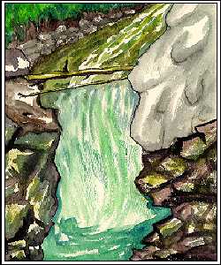
Stop One:The Canyon
Stop Two:Canyon Base & Creek Flood Plain
Stop Three:Under the Boardwalk
Stop Four:Lynn Creek Channel
Stop Five:Lynn Creek Braided Channel
Stop Six:Erratic Boulder
Stop Seven:Cliff
Geologic History of Lynn Valley
Appendix I Bibliography - Works Cited
Appendix II Water Colour Gallery
Appendix III Sketch Gallery
Executive Summary
����� The objective of the field trip was to view evidence of glacial and fluvial activity and analyse how the Lynn Valley Canyon was formed.
����� The base of the canyon is the Coast Mountain Range formed by volcanic activity approximately one hundred million years ago. Isostatic adjustment raised the volcanic range above sea level completing the orogenic process. Evidence includes an exposed igneous dike.
����� Subsequent to the formation of the Coast Range, three glacial and inter- glacial periods followed eroding the Coast Range to the present formation. Evidence of glacial activity include the formation of the U-shaped valley and the deposition of erratics, glacial till and tongue silt. Inter-glacial fluvial activity eroded the topography forming the Lynn Valley box canyon and rounded fluvial boulders. Deposition during these periods include peat layers, and alluvium.
����� At the time of viewing, the water level was very low, but there is evidence of a higher watermark level during the period of spring run-off as evidenced by boulder deposition and river debris in the form of large logs. The watermark level can be viewed by the undercut of soil below tree roots and the level of moss and fern growth on both the cut bank and point bar deposits.
�����
Lynn Valley Canyon is a beautiful treasure trove of geologic discovery.
Return to Index at top of Tour
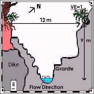
Stop One:
The Canyon
Pre-Stop:
Turn left down the stairs before the suspension bridge. Stop by the fence
overlooking the canyon.
What types of stream erosion are occurring here in the canyon? Can you cite evidence for them?
Estimate the approximate dimensions of the canyon, particularly the width
and depth of the stream channel.
�����
This section features a deep rock canyon approximately nine meters
high and approximately twelve meters across at the uppermost water level
marked by vegetation growth including ferns and the edge of the roots from
the trees. There is evidence of the high water levels by the large boulders
mixed in with the topsoil and interspersed among the tree roots and along the
sides and on the narrow path leading down from the edge of the upper
precipice. The walls of the canyon are marked by angular fractures of the wall
rock, possibly caused by frost shattering and abrasion. Ledges in the rock wall
have shallow potholes. The west side of the canyon features a vertical dike
that protrudes slightly, light grey in colour, which is resistant to erosion and
protects the granitic canyon wall adjacent to the dike downstream.
�����
At the time of viewing, the water level in the channel was relatively low
with a depth of approximately half a meter. At this level, the base of the
canyon gorge is narrow, approximately one and a half meters across: The
narrowing of the channel causes increased velocity and turbulence. The
erosion of the bedrock has formed a waterfall.
�����
Evidence of erosion include boulders of large, medium and small size
with pebbles at the sides of the channel. The types of erosion include
hydraulic action as evidenced by the rounded shape of the channels.
Abrasive erosion is evidenced by the rounded shape of the rocks and boulders
in and around the stream bed. It is reasonable to assume that there is also
some degree of solution erosion where dissolved chemicals are transported in
the stream water.
Canyon Sketch
Next Stop:
The end of the boardwalk at the bottom of the stairs along the edge of the stream.
Return to Index at top of Tour
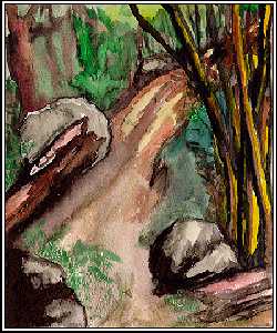
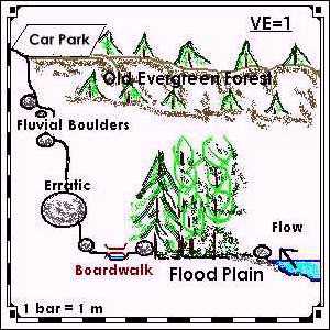
Stop Two:
Canyon Base and Creek Flood Plain
�����
The trail down from the canyon precipice to the flood plain has
evidence of the different levels of the creek bed by the large number of big
boulders and mixture of different size alluvium. In addition there is evidence of
undercutting of the banks by water erosion of the soil at the tree root level. At
the base of the canyon, the flood plain widens and is relatively flat ground.
The vegetation is comprised of relatively young stands of alder. There are a
few cedar trees that are approximately fifty to sixty years old.
Note where Lynn Creek abruptly narrows as it enters the canyon.
What is the reason for the narrowing of the channel here? Cite evidence for
this.
�����
Looking downstream, the canyon walls climb and narrow. The most
significant geophysical evidence to account for the narrowing of the channel
at this point is the thick vertical dike in the granitic wall. The dike protrudes
slightly from the wall, and protects the granitic wall downstream and adjacent
to the dike. The dike is comprised of igneous intrusive magma that cooled
slowly forming a smaller crystal structure that is stronger and more resistant
than the larger crystalline structure of the adjacent granitic plutons.
Note the very large boulder perched on the ground. How did it get there?
�����
This boulder is called an erratic. It appears too large to have been
transported by hydraulic action because it is significantly larger than the
largest sized boulders that are abundant in and around the stream bed.
Geologic chemical testing can prove that the composition of this erratic is
significantly different from the local rock composition. The erratic was
transported by glacial action which occurred several time in this area. This
erratic was probably transported to this location during the most recent
glaciation period, the Fraser Glaciation. Additional evidence of glacial
transport on the boulder is the sharp striated marks on this boulder. A boulder
transported by hydraulic lift would be rounded and smooth from abrasive
erosion.
Flood Plain Sketch
Next Stop:
Go back up the trail and underneath the boardwalk.
Return to Index at top of Tour
Stop Three:
Under the Boardwalk
Examine the exposed bank under the boardwalk.
Describe the texture and composition of the material. Speculate as to the
origin of this material. How old is it?
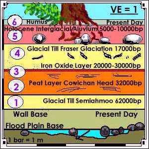
�����
The lowest layer of material at the base of the bank section is comprised
of a mixture of sand and small rocks. "Dense brown till containing 5%
subrounded stones grading to a massive dense brown silt and sandy gravel
which is probably Semiahmoo drift" (Maynard 35). This glacial till was
deposited during the Semiahmoo Glaciation period 62,000 years before
present (B.P.).
Examine the dark brown woody layer superimposed on the material you
described in last question. What is the origin and probable age of this
material?
�����
The dark brown woody layer is approximately half a metre thick and is
comprised of peat. This peat layer is dark brown and is organic. It breaks off
easily in horizontal type chunks or flakes. It was formed during the Olympia
non-glacial interval. The peat layer is part of the Cowichan Head Formation
(Maynard 35). During this period anaerobic conditions in swamp bogs did not
provide enough oxygen for bacterial decomposition of the organic matter.
The building blocks of peat are partially decomposed vegetation and peat is
primarily composed of carbon. The peat is dated at 32,000 B.P. (Maynard 35).
It is a very low grade fossil fuel and it is impermeable to water.
Note the layer superimposed on the layer in the last question. What is the
possible origin of this material?
�����
Superimposed on the top of the peat layer is a very thin reddish brown
layer comprised of iron oxides. The iron is carried in solution and precipitates
out in deposits. The iron oxides cannot leach down through the peat because
the peat is impermeable to water. The iron oxides must have been transported
in solution between 20,000 B.P. and 30,000 B.P., after the formation of the peat
and probably before the Fraser Glaciation period.
Describe the historical sequence of deposition at this point.
����� The historical sequence of deposition from the base layer to the top of the bank wall is:
- The first (bottom) layer is glacial till deposited during the Semiahmoo Glaciation period 62,000 B.P.
- The second layer is organic peat, part of the Cowichan Head Formation deposited during the Olympia non-glacial interval 32,000 B.P.
- The third layer is a reddish brown precipitate deposit of iron oxides transported in solution between 20,000 to 30,000 B.P.
- The fourth layer is comprised of small boulders, sand, and fine gravel deposited during the Fraser Glaciation period, 17,000 B.P.
- The fifth layer is a soil profile that contains evidence that the creek bed used to be at the top level of the bank. There are medium and small boulders below the humus layer of the soil. This alluvium was deposited during the Holocene Epoch 5,000 to 10,000 B.P. when the Fraser River Delta was forming and the sea level rose 10 metres. The increased water level and alluvial transport was due to the melt down of the Fraser Glaciers.
- The top layer is the humus layer of the soil formed from decaying organic matter in present time.
Under the Boardwalk Sketch
Next Stop:
Walk a short distance upstream along Lynn Creek to the wide gravel bank.
Return to Index at top of Tour
Stop Four:
Lynn Creek Channel
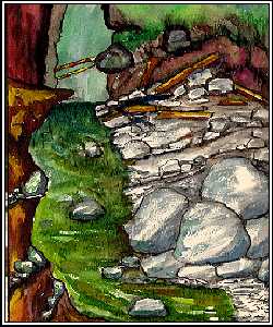
�����
Walking towards Stop Four through the old flood plain, the ground is
relatively flat with no noticeable slope. The area is vegetated with young trees
and saplings. The oldest trees are estimated at fifty to sixty years old. The area
is strewn with alluvial boulders and organic debris deposited by the river. There
is a small feeder stream off to one edge of the flood plain area with small
rounded rocks and pebbles in the stream bed. The flood plain slopes down
towards the main Lynn Creek Channel, Stop Four.
- Estimate the width and depth of the channel in metres.
�����
The channel is a wider U-shaped channel than the box canyon down
stream. At time of viewing, the width of the water channel was 5.5 metres.
The average depth the water channel was 1.5 metres. The depth varied from
2 metres maximum to .3 metres minimum due to the deposition of the rocks in
the creek bed.
Can you determine how much higher the water can get in the channel?
The maximum level is known as bankfull. Cite evidence for this.
�����
The maximum channel width is 20 metres. The maximum channel depth
is 3 metres on the cut bank side and 2.5 metres on the depositional or point bar
side. The maximum level of the channel is evidenced by the moss line on the
rocks, the undercut and erosion of the soil around the tree roots, and the
height of the line of ferns growing in the soil.
Are you standing on a cutbank or a point bar? Cite evidence for your
answer.
�����
This location is on a point bar as evidenced by the accumulation of
sedimentary bedrock including large, medium, and small sized rounded rocks
and an accumulation of fine grained sand deposits.
Streams can transport sediment (clastic and chemical) in three ways. What
type of sediment transport is occurring in Lynn Creek? Cite evidence for
this. What time of year does most sediment transport take place?
�����
There are primarily three types of sediment transport occurring in Lynn
Creek: suspension, traction and saltation, and solution.
�����
Suspension carries very fine particles of sediment in the stream as
evidenced by the deposits of fine sand on the point bar.
�����
Traction and saltation occur when the rocks are dragged along the
bottom of the stream bed by the velocity of the stream, or are bounced and
rolled along the stream bed. Evidence of traction and saltation include the
composition of the streambed which is comprised primarily of rounded rocks of
assorted sizes on the point bar and in the stream bed.
�����
In addition, minerals may be carried in solution, a chemical form of
transport. Chemical analysis of a water sample is required to identify the
mineral types in solution. However, some minerals may precipitate out of
solution and stain the rocks along the course of the channel (Christopherson
422-424).
�����
The majority of sediment transport occurs during the spring season when
the snow accumulated at higher elevations on the local orographic
formations melts due to increased insolation. During the spring season, the
snow melt and spring precipitation drains into the local river basin. The excess
water melt saturates the soil past the level of cohesion and mass erosion
ensues. Rocks and soil are loosened and swept downstream. As noted earlier
in part b the maximum water level of the channel is significantly higher than
the present viewing level. The area from the low summer creek bed back
across the flood plain to the boardwalk is littered with larger alluvial boulders
and large masses of organic river debris.
Stream discharge is the volume of water being transported past a point over
a given amount of time (expressed as cubic metres per second) by the
formula:
- Q=VA, where
- Q=stream discharge
- V = velocity in metres per second
- A = width x depth (square metres)
Determine Q (Discharge) for Lynn Creek
-
Velocity: measured by the average time (seconds) for an orange to travel 20
metres on the surface of the creek.
V = 20m �[(49s + 39s + 24s)�3] = 0.54 ms-1
V = 0.54ms-1
Area = width x average height
A = 5.5m x 1.5m = 8.3m2
Discharge (Q) = VA
Q = 0.54 ms-1 x 8.3m2 = 4.5 m3s-1
The discharge of Lynn Creek at this point is 4.5 m3s-1.
Channel Sketch

Next Stop:
Continue along the trail to the next major clearing on your right.
Return to Index at top of Tour
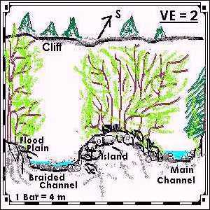
Stop Five:
Lynn Creek Braided Channel
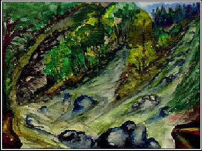
Notice how the shape and appearance of the creek has changed.
How would you describe Lynn Creek at this location?
�����At this location, the valley is wider and flatter with no noticeable slope
gradient. The Lynn Creek forms a braided stream pattern with channels
flowing around an island formed by sedimentary deposition. The island is
vegetated by coloniser species including small grasses, shrubs, and alder trees.
There is also evidence of fluvial deposition of rocks and stream debris in the
form of larger boulders and organic debris. The surface of the island is rocks,
pebbles and coarse to fine grained sand. The area has several point bars of
deposition.
How many channels are there?
�����
At this point there are three main braiding channels of Lynn Creek.
Braiding occurs when there is an equilibrium between the velocity of the water
and the deposition of materials (Christopherson 426). In this case deposition is
seasonal from the spring melt down, and evidence of significant mass erosion
of the cliff banks 30 metres upstream from the area of braiding.
Why do you think the valley is wider here than at Stop Two and Four?
�����
The valley is wider here primarily due to the softness of the granitic
bedrock. Previous glacial activity would have eroded the U-shaped valley
with the grinding and abrasive action of the till carried in the tongue. Pursuant
to the retreat of the glaciers, the stream bed was further eroded by hydraulic
action, abrasion, and saltation.
�����
Stop Four is narrower because it is a point of deposition on the point bar.
�����
Stop Two is even narrower due to the protective capping of the dike
which protrudes protecting the adjacent granitic bedrock wall.
Braided Channel Sketch
Next Stop:
Continue up this left-handed channel to the very large rock in mid-channel.
Return to Index at top of Tour
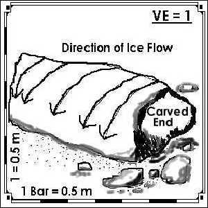
Stop Six:
Erratic Boulder
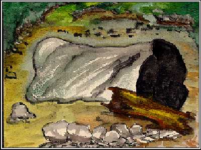
What is this large rock?
�����
This large boulder is either an erratic or an exposed batholith. It is difficult
to ascertain without a doubt because the base of the boulder is below the
surface ground level, thus it is unknown if this if a free form boulder, or a
component of the bedrock. It is most likely an erratic because there is an
abundance of erratics that are in the flood plain area right back to the top of
the box canyon. The boulder has evidence of striations and a sharp carved
feature that is more similar to a Roche Montonnee than a fracture caused by
frost shattering. Chemical analysis of the component materials would help
identify if the rock is similar or dissimilar to the bedrock in the area.
Is this a depositional or erosional feature? How was it formed? How did it
get here?
�����
It is very unlikely that this boulder is an alluvial feature transported by the
creek flow because it is significantly larger than the other boulders deposited
by fluvial process in the area as observed in the flood plain and along the
embankment region.
�����
An erratic is a depositional feature transported by glacial activity.
Material transported by glaciers are a result of orogenesis, erosion and
transport. Erratics are usually identified by rough striations or grooves in the
rock caused by the abrasive grinding action of the rock over other bedrock
carried in the tongue of the glacier. Another identifiable feature of an erratic is
that the mineral composition of the rock is different from the adjacent bedrock
in the region in which the erratic is deposited (Christopherson 521-522).
Erratic Sketch
Next Stop:
Continue up the channel to the base of the cliff ahead. Caution: Keep away from the base of the cliff due to mass wasting - you do not want to become a part of the debris flow.
Return to Index at top of Tour
Stop Seven:
Cliff
Observe and describe the cliff above you.
�����
Past the erratic and over the bouldered sandy surface of the lightly
treed island, the braided stream bends into a cliff face. The cliff bank is
undercut. There is a 5 metre pile of tallus deposited at the base of the cliff
resting at an angle of 45�. Human intervention placed piles of small and
medium sized boulders near the base of the cliff to provide additional stability.
There is small shrubbery and small trees growing at the base of the cliff. As the
slope increases to vertical there is no vegetation on the undercut cliff or the
steep slope adjacent to the exposed cliff. There are mature trees growing on
top of the cliff.
Estimate the height of the cliff.
�����
The estimated height of the cliff is 20 metres.
Sketch the cliff and label the distinctly different layers (formations) of material.
Describe the depositional environment for each layer.
Cliff Sketch
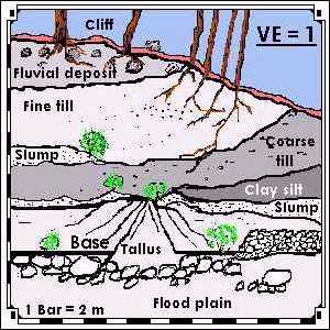
�����
The cliff face is composed of soft sedimentary layers and is poorly
stratified. Generally speaking the layers and the depositional environments
from the base of the cliff to the top of the cliff are:
- The base layer is fine clay deposited during the Olympia non-glacial interval.
- The next layer is fine sand and small rocks deposited as glacial toe silt during the Fraser Glaciation period.
- The next layer is larger boulders lain down during the post glacial flooding period after the Fraser Glaciation period.
- The top layer is soil and humus.
What will this cliff look like twenty years from now?
�����
Twenty years from now there will be increased slumping as the cliff
continues to erode at the undercut. If the organic material and soils slump
down to the base, there will be increased vegetation at the base in the form
of smaller shrubs and other coloniser plants. Boulder debris will accumulate as
gravity pulls down the boulders deposited during the flooding period. As the
mass wasting accumulates, and the new vegetation takes hold, the cliff will
eventually look like a rounded hill.
Return to Index at top of Tour
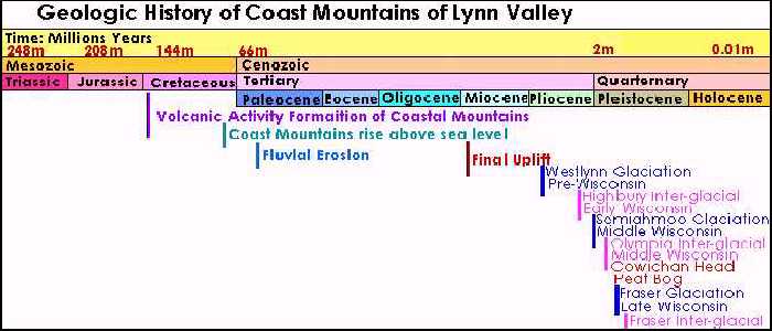
Geologic History of Lynn Canyon:
Based on your observations of your tour, put together the geologic history of Lynn Valley
beginning with the Coast Range Orogenesis to the present.
�����
The geologic history of Lynn Valley is complex due to the frequency of
terrestrial changes and the mid-latitudinal location of the area.
�����
The orogenesis of the Coast Range begins with plate tectonics. The
area is above the converging subduction zone where the oceanic Pacific
plate subducts underneath the Explorer Plate , the Juan de Fuca Plate and the
overriding North American Continental Plate. When the heavier oceanic plate
subducts underneath the lighter continental plates, subduction occurs deep in
the Asthenosphere forming molten magma. The magma rises up through the
Asthenosphere and the crust forming volcanic mountains.
�����
The Coast Range is comprised of volcanic mountains formed
approximately one hundred million years before present (B.P.) (Maynard 7)
during the Mesozoic Era, Cretaceous Period (Christopherson 313). The slow cooled igneous rock formed the granitic bedrock of the Coast
Range.
�����
The Coast Range surfaced above sea level approximately 80 million
years B.P. (Maynard 8) during the Mesozoic Era, Cretaceous Period
(Christopherson 313). Over the next 40 to 80 million years B.P. fluvial action
eroded the tops of the volcanic mountains carrying sedimentary deposits into
the Pacific Ocean (Maynard 8). The fluvial action lightened the load on the
North American Continental plate, and isostatic adjustment raised the Coast
Range to their present elevation in this final uplift (Maynard 8). This occurred
approximately 20 million years B.P. during the Cenozoic Era, Tertiary Period,
Miocene Epoch (Christopherson 313).
�����
Up to this point, the climate was relatively warm because life evolved
including the appearance and disappearance of the dinosaurs, and the
evolution of large mammals and humans. The climate changed significantly
and entered into a cooling period that began approximately 1.65 million years
B.P. (Christopherson 530) to 1 million years B.P. (Maynard 8) marked as the
Pleistocene Ice Age Epoch (Christopherson 530).
�����
During the Pleistocene Ice Age, the Coast Range experienced three
separate glacial and inter-glacial periods, including the current inter-glacial
present day period. The mammals and humans must have migrated in
response to glacial advancement and retreat of the glaciers but the records
of their occupation are buried in till and washed away by fluvial action.
�����
The first glacial period, the Westlynn Glaciation occurred more than sixty
thousand years B.P. during the early Wisconsin major glaciation
(Wisconsin) period followed by the Highbury inter-glacial period (Maynard 10).
There is little evidence or record of this period at Lynn Valley due to
subsequent glacial/inter-glacial activity.
�����
The second glacial period, the Semiahmoo glaciation occurred more
than fifty thousand years B.P. during the middle Wisconsin glaciation period
(Maynard 10). There is evidence of Semiahmoo till deposits at Lynn Valley at
the base of the peat wall discussed in stop three. The Semiahmoo was followed
by the Olympia inter-glacial period.
�����
The Olympia inter-glacial period occurred between thirty to sixty
thousand years B.P. during the middle Wisconsin, lasting about 30,000 years
(Maynard 10). During this period, the climate was warm and wet as evidenced
by the Cowichan Head Formation of the peat bogs (Maynard 10). The peat
layers found at stop three formed from peat bogs which form in wet anaerobic
conditions where there is not enough oxygen for bacteria to completely
decompose organic material. There is evidence of Olympia clay silt deposited
at the base of the cliff wall in stop seven. The clay layer is
darker in colour because the particles are fine and they retain water due to
increased surface area and water tension. This warm period was short and
followed by the next period of glaciation.
�����
The third, and most recent, period of glaciation the Fraser Glaciation,
occurred approximately twenty to ten thousand years B.P. during the late
Wisconsin (Maynard 10). During this period it is most likely that the wide U-shaped valley of the Lynn Valley flood plain was
formed (stop one, stop five) and the erratic boulders
were deposited (stop two, stop six) as the glacier moved to the
Pacific Ocean. Other evidence of the passage of this glacier include the till
deposits found at stop three under the boardwalk in the peat wall above the
layer of peat and the layers of coarse till found in the cliff wall
above the fine clay silt in stop seven. This most recent period of
glaciation carved the Coast Range landscape to the present form and shape.
�����
The final shaping of the Coast Range occurred during the third inter-
glacial period, the post Fraser Glaciation period from approximately ten
thousand years to present day during the Holocene epoch (Maynard 10). The
climate warmed, and the Fraser Glacier retreated. The meltwaters carried
alluvium into the Lynn Valley eroding the valley floor and transporting boulders
and sediment. Evidence of the high level of the waters is found in Lynn Valley
in the soil profiles at stop three (peat wall) and
stop seven (cliff wall).
The large rounded boulders are mixed in the soil profile below the tree root
level. There are large round smooth boulders deposited along the flood plain
and up at higher elevations around the box canyon. The water levels rose ten
metres forming the Fraser River Delta and the fjord coastline that is presently
familiar.
�����
The Coast Range that formed a hundred million years ago has undergone the
cyclic advance and retreat and glaciation, part of the Earth�s long term cycle
of cooling and warming periods. The Coast Range is a relatively young range
in terms of Earth�s geomorphic history. The retreat of the last period of
glaciation and the alluvial erosion of the post Fraser period has exposed a
geomorphic time record. The igneous dike in the box canyon is from the
period of volcanic formation. The region is above a subduction zone of
converging plates. Associated with subduction zones is earthquakes and fault
lines. The erosion of the canyon granitic base rock most likely lies along a fault
crack in the bedrock.
�����
Much of the history of Lynn Canyon has been altered due to stratification
inversion and erosion.
�����
Piecing together the history of the Lynn Valley is like putting together the
pieces of a puzzle that have been all shook up and spread out haphazard
across the playing field.
Return to Index at top of Tour
Table 1: Geologic History of Lynn Canyon
Return to History Section at Stop Seven
Return to Index at top of Tour
Appendix I
Bibliography - Works Cited
Armstrong, Dr. John E. Vancouver Geology. Vancouver, B.C.
Geological Association of Canada, 1990.
Christopherson, Robert W. Geosystems : An Introduction to Physical
Geography. 2nd ed. New York: MacMillan, 1994.
Maynard, Denny. "Guidebook for Geologic Field Trips in the Lynn Canyon-
Seymour Area of North Vancouver." Vancouver, B.C. Department of
Geological Sciences, University of British Columbia, 1977.
Wright, Judith. "Lynn Canyon Field Trip Assignment".Langara College. Vancouver,B.C. 1986.
Return to Index at top of Tour
Appendix II
Water Colour Gallery
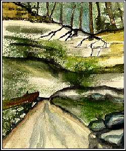
Stop One:The Canyon
Stop One
Stop Two:Canyon Base and Creek Flood Plain
Stop Two
Stop Three:Under the Boardwalk
Stop Three
Stop Four:Lynn Creek Channel
Stop Four
Stop Five:Lynn Creek Braided Channel
Stop Five:
Stop Six:Erratic Boulder
Stop Six
Stop Seven:Cliff
Stop Seven
Return to Index at top of Tour
Appendix III
Sketch Gallery
Stop One:The Canyon Sketch
Stop One
Stop Two:Canyon Base and Creek Flood Plain Sketch
Stop Two
Stop Three:Under the Boardwalk Sketch
Stop Three
Stop Four:Lynn Creek Channel Sketch
Stop Four
Stop Five:Lynn Creek Braided Channel Sketch
Stop Five
Stop Six:Erratic Boulder Sketch
Stop Six
Stop Seven:Cliff Sketch
Stop Seven
Return to Index at top of Tour

 email Waterose
Please Sign My Guestbook
Please View My Guestbook

| Articles | Projects | Resume | Cartoons | Windsurfing | Paintings | Album |
 | ||||||