ANCESTRAL LAND
![]()
ANCESTRAL LAND
![]()
On July 15, 1674, the governor
Frontenac
concedes to Olivier Morel, seigneur de la Durantaye, the
seigniory of Kamouraska, that is to say "trois lieues de front
le long du fleuve Saint-laurent, savoir deux lieues au dessus de la rivière
appelée Kamouraska et une lieue au dessous, icelle comprise, avec
deux lieues de profondeur dans les dites terres, ensemble les îlets
étant audevant des dites trois lieues pour du tout jouir en fief,
seigneurie, haute, moyenne et basse justice." The seigniory
of Kamouraska will be cleared only about twenty years after its concession.
From 1694 to 1700, 27 families are established there on their plot of land.
Forty years later, 320 people live in the Parish of Saint-Louis-de-Kamouraska,
founded in 1709; unfortunately the registers concerning the years
1709 to 1727 disappeared. Kamouraska
... this name will soon design a village, then a few centuries later, it
will extend to a large area. "Kamouraska", i.e "were there is rushes
at the edge of water".
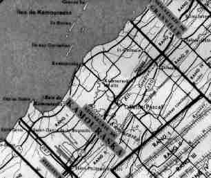
Extent of the seigniory of Kamouraska
On November 5, 1680, Olivier Morel sells his
seigniory of Kamouraska to Charles-Aubert de la Chesnaye, already
seigneur of Rivière-du-Loup. On October 18, 1700, he gave
the seigniory to his son, Louis-Aubert de Forillon. At this
time, the seigneur,
usually a noble man or a regiment's officer, received from the governor
or the intendant a land in fee at a charge of towards the Crown.
For his part, the seigneur conceded or rented lands to "colons" (settlers)
who were to pay him a taxable quota of 5 sous (pennies) per cleared arpent,
to grind their grain in the communal mill, to defend the country by the
weapons if necessary. With these taxable quotas and revenues, the
seigneur layed out roads, build the communal mill, etc...
On January 1692, Charles-Aubert de la Chesnaye, at this time seigneur, made draw up by land-surveyor Le Rouge the contract "measuring of the lands and seigniory of Kamouraska". According to Chambalon notary records, we learn that from 1694 to 1701, 33 concessions were conceded by Charles-Aubert de la Chesnaye. Thus, on June 30, 1695, there is concession to Pierre Micheau living at Kamouraska "land consisting of 12 arpents of frontage (on the river) by 30 in depth, bordered on the south-west side by a brook, going up the river three arpents and on the north-east corner up the small brook that has no name and will be called Boisverd or Boisvert, nine arpents." Pierre Micheau thus owns the largest land granted at Kamouraska. The concession to Pierre Michau, the son, had only four arpents of frontage by thirty in depth, bordered to the "sorouest (south-west)" by the land of Pierre Fournier, his uncle, and to the "nordest (north-east)" by that of René Pelourde.
Owing to the plan of the seigneurie of Saint-Louis-de-Kamouraska
dressed in 1946 by Arthur Massé and whose names of the settlers
were recalled on the official report of the land-surveyor Noël
Beaupré in 1726, one can recall the two lands on the first concession
boundering the St. Lawrence River.

The land where Pierre Micheau died is the concession
bearing the name "héritiers Pierre Michaud". The concession
more to the west bearing the name "Pierre Michaud" is the land of
his elder son. Mr Guy Drapeau, in charge of the Art
and Historical Center of Kamouraska, informed me that this concession
today includes plots number 12 to 23 from the land register
of Saint-Louis-de-Kamouraska.
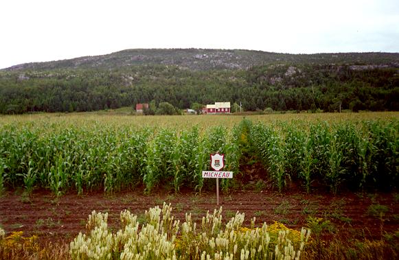
The ancestral land at the eastern of Kamouraska, in front of l'îlet
de la Ferme
 From July 29 to August 8, 1999, Kamouraska was celebrating its 325th anniversary.
![]()
