I recently read a book called the "C & O Canal Companion." For a fresh challenge to my mind and body, which is fast approaching middle age, I became motivated to consider bicycling, in portions, the entire C & O Canal National Historical Park, which straddles the Potomac River for 184 miles from Georgetown to Cumberland, Maryland.
In my past years as a Boy Scout, bicyclist, etc. in the Washington D.C. area, I have frequently been on the first, approximately 14 mile portion of the canal from Georgetown to Great Falls. I have also periodically visited the canal at Antietam and Harpers Ferry. Along with the personal physical challenge of this endeavor, I really look forward to seeing the more obscure and historical places along the Potomac that I have heard and read about.
I will try to document this journal of sorts with photographs in a unique way. I recently purchased a piece of software that digitally stitches scanned photographs into panoramas and "virtual reality" images (for viewing these fascinating 360 degree images, of which three are linked on this web page, you'll need to download the free Quicktime movie viewer, available *here*). I thought with the many potentially interesting vistas, it was a good opportunity to try it. From my limited experience with this format, I have found the best way to do these kind of photographs is to use a SLR camera with a 28mm wide-angle lens, a sturdy tripod and a level. Unfortunately, this equipment is a bit much to lug along even on a relatively short bicycle jaunt. For the first trip, I brought along a compact 35mm camera and tried to carefully frame panoramic shots.
To test myself in a "shakedown" trip, I decided to start on a portion of the canal I had not yet seen. Here is an account of my first visit, a round trip between Great Falls (mile 14.4) north to Edwards Ferry (mile 31), about 34 miles.

(Borrowed from theWashington, DC Urban ATB Page)
Friday, June 18, 1999
I arrive at Great Falls (mile 14.4) in my car shortly before noon, after taking an unexpected detour to avoid a typical Beltway accident. Usually popular Great Falls is blissfully quiet, its large parking lots scattered with just a few dozen cars and only one tour bus. After unloading my gear, I quickly wolf down a sandwich and Coke, use the restroom, and head north on the towpath.
It's the first time in many years I have biked the trail, and the first time I have used my 8 year-old mountain bike on the towpath. I gleefully note to myself that this is what the bike was made for. The pedaling is easy at first, and I soon maintain a steady speed of about 11-13 mph. It is a little cool, in the upper 60s along the shaded towpath. Despite the perfect weather, after two or three miles I actually have a pang of doubt about whether I can make it the whole, planned way. I confront the fact that it's a few hours of constant pedaling ahead. The trail is muddy at spots, and I have to steer around puddles. Sometimes the pedaling is sluggish and I gaze at the back tire wondering if I have a flat (this was a frequent occurrence in my touring bike days, with 90 psi tires).
After awhile, there is no one within sight in front or in back of me. The scenery is spectacular, the glittering Potomac to my left, and the quiet pond-like stillness of the canal to my right. As I approach Pennyfield Lock (mile 19.6), I see what appears to be a large, long-legged dog about 50 yards ahead of me. I think, "Oh, man, maybe I should have brought mace to handle unleashed mutts!" Just as suddenly, I realize it is a deer, and the creature makes a panicked splash into the canal and swims to the wooded shore. I spontaneously grin, as a swimming buck is a wildlife sight I can't say I have ever seen.
Five miles behind me already, Pennyfield Lock
seems like a good spot to take a fast breather and to get a  panoramic
shot with my camera. A couple of old buildings and the lack of anyone around
seems to make for a good photo op. The book says this was a favorite fishing
spot for President Grover Cleveland, who apparently spent the nights in
one of the buildings here. I stand on the wooden bridge over the lock and
bracket the camera carefully, my elbows tightly at my sides, so that I
can make a level scan of the scenery. It will take around a dozen shots,
so I hit the shutter and move to my left after the shutter releases to
frame a new view. I am sometimes unsure about whether the shutter releases
because the water pouring through the lock gates masks the sound of the
camera motor. To be sure, I take a couple of extra shots to make sure I
get the scene, though I know it won't be perfectly matched.
panoramic
shot with my camera. A couple of old buildings and the lack of anyone around
seems to make for a good photo op. The book says this was a favorite fishing
spot for President Grover Cleveland, who apparently spent the nights in
one of the buildings here. I stand on the wooden bridge over the lock and
bracket the camera carefully, my elbows tightly at my sides, so that I
can make a level scan of the scenery. It will take around a dozen shots,
so I hit the shutter and move to my left after the shutter releases to
frame a new view. I am sometimes unsure about whether the shutter releases
because the water pouring through the lock gates masks the sound of the
camera motor. To be sure, I take a couple of extra shots to make sure I
get the scene, though I know it won't be perfectly matched.

Click on images for larger view
As I saddle up again, a few hardcore bicyclists (my term for anyone with more equipment and in better shape than me) pass and acknowledge me, including a couple in the their early thirties. They're loaded down with packs, surely doing the whole run this weekend. As the towpath gently curves around a bend, I soon pass the cliffs of Blockhouse Point (mile 21), the Civil War Union outpost overlooking the Potomac. I stop and stand on a concrete embankment the size of a highway Jersey barrier that is on the river side of the path (are those there for flood control, I wonder?). I catch sight of a hawk or turkey vulture soaring high with the cool breeze coming off the river. I wish that I had room to pack my Peterson field guide.
On the trail for over an hour now, I start to feel some slight indigestion. I'm not sure it was a good idea to eat that sandwich right before heading off.
 I
pass the Riley's Lock and the Seneca
Aqueduct (mile 22.7), where a group
of hardcore bicyclists are resting. It is a unique spot because it is the
only place along the canal where lock and aqueduct structures are together
in one place.
I
pass the Riley's Lock and the Seneca
Aqueduct (mile 22.7), where a group
of hardcore bicyclists are resting. It is a unique spot because it is the
only place along the canal where lock and aqueduct structures are together
in one place.
Passing the aqueduct, the canal is woodland, devoid
of water, and there is a canopy of forest greenery that limits the view
of the river. The trail gets a tad bumpier, too. 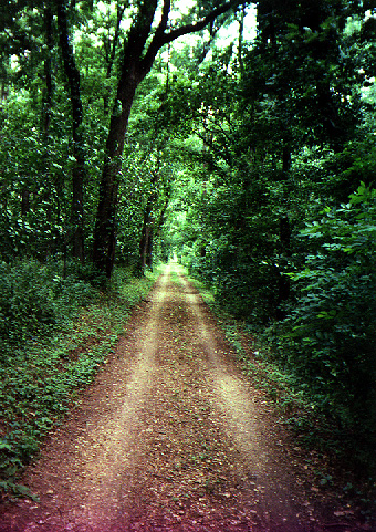 I
am startled a couple of times as small rocks pop off my rear tire. Around
this time I also start to understand why people wear those goofy, tight
and padded bike pants. I resolve to pick up a pair for the next trip. It
is at this point I realize that it will be too long a haul for me to make
it a full 20 miles to White's Ferry. I figure I will call it quits after
about a 17 mile straight trip, stopping at Edwards Ferry.
I
am startled a couple of times as small rocks pop off my rear tire. Around
this time I also start to understand why people wear those goofy, tight
and padded bike pants. I resolve to pick up a pair for the next trip. It
is at this point I realize that it will be too long a haul for me to make
it a full 20 miles to White's Ferry. I figure I will call it quits after
about a 17 mile straight trip, stopping at Edwards Ferry.
As I zip through the endless woods, I recognize that it is pretty difficult to be psyched for the trail ahead when you know you have to backtrack over the same territory. I resolve to make future trips one way for each section of the canal that I cover.
At mile 30.5, the Chisel Branch Campsite, I start to slip by a few people who are resting and eating lunch there. One is this solitary fellow with a huge, framed backpack and loaded-down bike. One of two women riding together call out to me to ask if I had been at Great Falls earlier. It turns out these two are heading from Great Falls to Harpers Ferry that day. They plan to stay at a hotel there for two nights, and are carrying lots of clothes and gear. In their thirties, they have biking outfits on and fairly decked-out hybrid bikes, but don't look hardcore enough to be doing nearly 50 miles in one day. None of them had gone this far on the trail before. One of them complains good-naturedly of the bumpy ride at this point on the path, and jokes that she was going to need a lot of Ben-Gay. They don't know exactly where they are, and didn't bring a map because of weight concerns. I show them a map in my book. As I bike on, I wish them luck, and I figure that they were sure going to need it. (Two days later the area gets soaked by a whole day of heavy rain. I really hope they were able to get a car ride home. Riding the towpath would have been impossible).
A short distance from the campsite is Edwards Ferry. I rest at the boat dock there and try to call home on the cell phone to check in. It seems I am too far out of range to get a signal. So much for the utility of bringing an emergency phone! I look at the Goose Creek River Lock and the adjacent whitewashed and boarded-up, brick Jarboe's Store. Nearby is the marker for mile 31. I am ready to head back. A total of 34 miles is enough for this out-of-shape bicyclist.
Just two miles later, at mile 29, I sit on the marker feeling a bit hungry and pooped out. I wonder if I can make it all the way back without a dozen rest stops. It is after 2PM. I have perhaps less than a cup of water in my single water bottle, and the well I looked at from the earlier campsite seemed awfully dry (and from some accounts too rusty to drink from). I remember that I had bought an overpriced peanut butter "PowerBar" for a munchie, and I quickly eat it, taking small sips of my now precious water. It somehow rejuvenates me (though I'm sure it's mostly a placebo effect), and I push on.
My speed now slips to an average of 9 mph. The woods seem to go on forever. I think that I might bring a walkman along next time, especially if I do it solo. Without a companion, it is a somewhat ponderous trip. Once I am on the wider, less rocky towpath again, it gets easier. I stop again at Blockhouse Point to take a previously framed pano shot. Once again, it is still and beautiful, with no human beings around.

Click on image for larger view
As I pass the Dierssen Waterfowl Sanctuary to my right, I spot a Great Blue Heron cruising for a touchdown in a algae covered swamp. I wonder to myself why this majestic animal isn't the state bird instead of the Baltimore Oriole. A few hundred feet later, I see a guy with high-powered binoculars and a telephoto lens. It must be birder paradise today.
At mile 20, I spot the backpacker from the campsite a ways back. How on earth does he pedal with that huge pack? I figure him for a college student at George Washington University doing a gonzo end-of-semester trip. As gradually more people appear on the towpath, I try to say "hi" to people approaching me on bikes or hiking. About half acknowledge me. That seems about right for us city people. I imagine some bikers are too busy straining to keep pace and are too busy for pleasantries. To give you an idea of the amount of folks I see on the path this day, I end up using the handlebar bell just twice.
I finally get to Swains Lock, a couple of miles from Great Falls. I get a drink from a water fountain that tastes terribly metallic. Though I am now having visions of the gloriously cold and bubbly drink, no Cokes are being served from the refreshment stand. I think I can make it until I get to my car and cooler.
As I pedal into Great Falls, I go past the parking lot over to the falls' footbridge. I want to get one final panoramic shot. I lock the bike up and plod clumsily, as if I were an astronaut on the moon, from being on the bike for nearly 2 1/2 straight hours (my breaks are never more than five minutes). There are 50-75 tourists around - not a bad number compared to crazy crowded weekends I have seen here in the past. When I get to the end of the footbridge, I quickly step up to a rock and shoot away. Unfortunately, I run out of film one shot short of a full 360 degree panoramic. Afterwards I notice there are three or four artists sketching the falls this extraordinarily pretty day.

Click on image for larger view
At my car I guzzle two cans of Coke and enjoy a wonderfully cold apple I had stored in the cooler. I hang around in the perfect weather and read a book until rush hour traffic ebbs.
EGT 7/12/99Next..... Edwards Ferry to Harpers Ferry