 Back to Leclair home page
>>> CONSTRUCTION ZONE Last Updated: Mon May 1, 2000 <<<
Log for Canoe Trip 00A Back to Canoe Archives / Back to Doug's Canoe Page
Dates: Fri May 19 - Mon May 22, 2000,
"The Guys Spring Trip"
Participants: Larry, Doug, Scott, Kevin, Jim, Ian
Travel Route: on reservation number 761040:
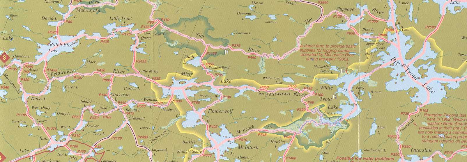
Algonquin access 3, Magnetawan L, Hambone L, Daisy L, Petawawa R, Little
Misty L, Misty L (camp here). Day trip eastward on Petawawa R, turning Westward
at Grassy Bay to McIntosh L, Timberwolf L, and back to previous site on Misty
L. On last day go back westward on Petawawa through Little Misty L, Daisy
L and camp on Hambone (due to Daisy being full up).
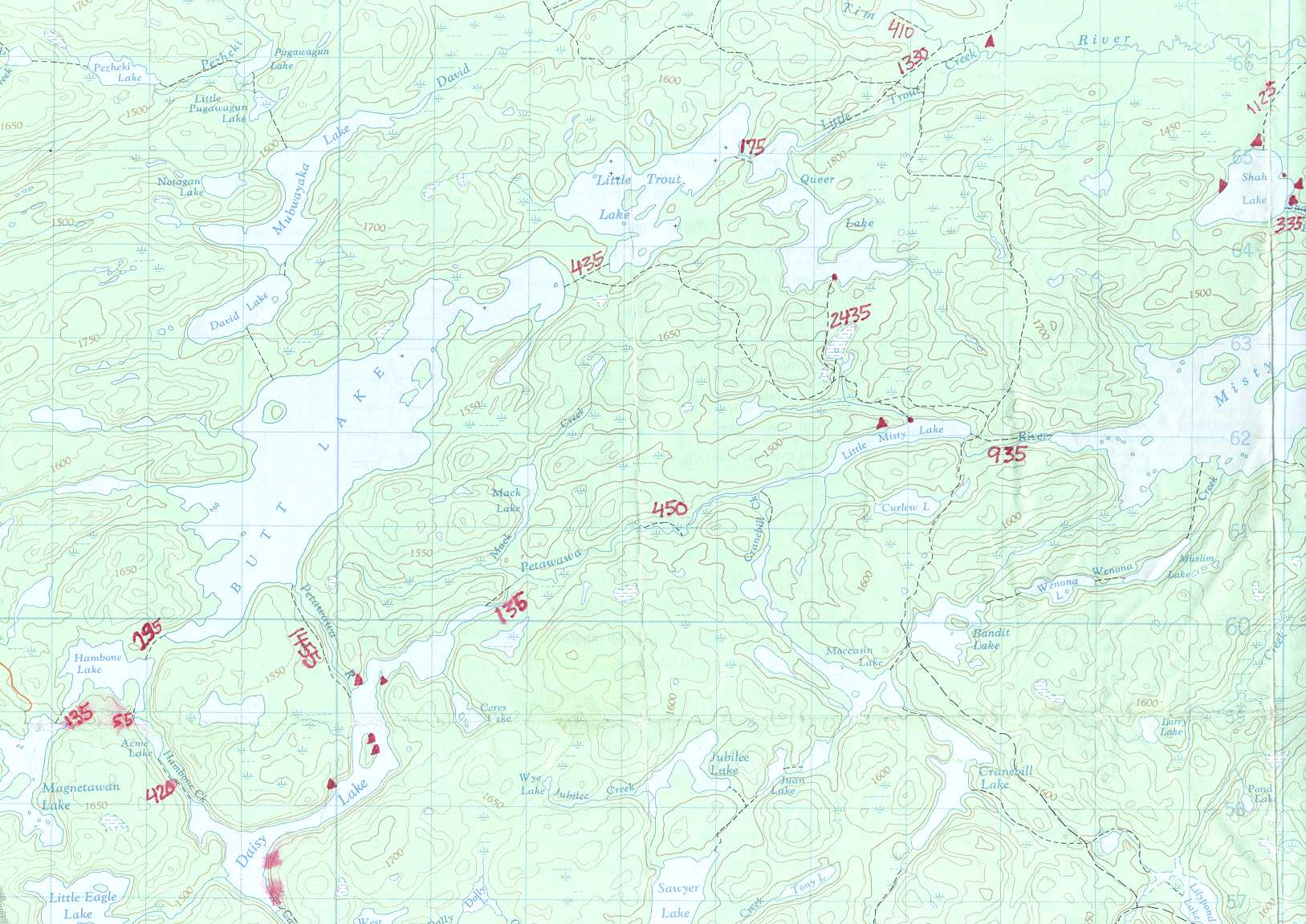
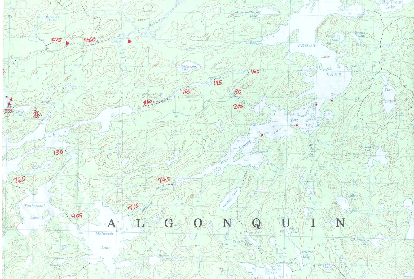
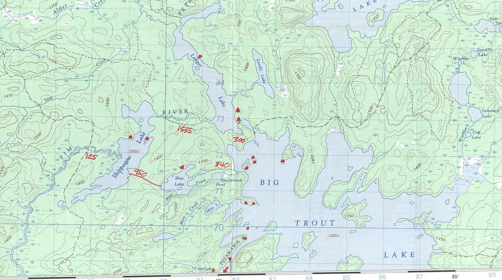
Map Information: The relevent
Top map identifiers are: 31 E/10, & a bit
of 31 E/15
Online top map excerpts: West
part, East part,
North part. (These are large
- you may want to save them to your local disk.)
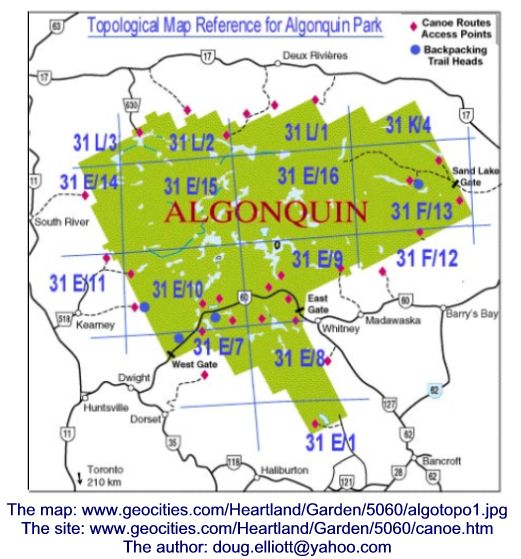
Online park map excerpts:
Access 3, Butt L to Big Trout L,
Roadmap: unneeded.
Access instructions from park map for access 3: At Emsdale, north of Huntsville
on Hwy 11, turn east and follow Hwy 518 for 8 km to the village of Kearney.
Park permits and information must be obtained at the park office in the Kearney
Community Centre located at the main intersection in the village. Then continue
on Hwy 518 for 14.4 km and turn right onto the Forestry Tower Road. Follow
it and signs for another 24.2 km to the access point on the NW shore of
Magnetawan L.
Pre-trip Plans & Comments:
-first trip with Kevin's neighbour Ian - guess if you can put up with Kevin,
getting along with the rest of us won't be a challenge (grin).
-a compromise between our recent "base camp" approach and the "travel every
day" approach.
-should we bring bucksaws, pulleys & workgloves to do serious route spring
cleaning?
-this is shaping up to be quite the nerdware trip: Ian and Scott both have
GPS units, Larry may bring his palm pilot to record the trip log, Kevin will
be glued to a radio for the Stanley Cup playoffs, and I usually have a camera
at the ready.
-Doug's participation was a little iffy, due to work considerations, but
looks good now.
-I was hoping to get pictures for the '97 trip online quickly, but that trip
was before I started getting our pictures scanned as part of the developing.
I'll have to scan the prints myself, at work.
-If I can make it on this trip, I'm going to make a concerted effort to travel
light - sorry guys, no hanging easy chair.
-I'm thinking about borrowing my nephew's canoe - lighter and bigger than
my submarine.
Chronology:
(Click on pictures
to see full sized photos).
| thumbnails | narrative tales |
| In the planning process we had a few iterations on the dates for the trip and the route, but everything came together, and we ended up with an itinerary that worked for everyone. | |
| initial scribbles: -challenges getting 5 people plus packs (especially Kevin's new monster pack) into doug's van -stop at info center where local agent tried to tell us the Swift Kipawa canoe on display weighed 34 pounds, and also suggested Welcome lake as a great Algonquin camping area with sandy beaches -van gas alarm comes on on gravel road on the way in "no problem - eighth of a tank left" -Londoners late to the put in point by half an hour, pretty congested with cars and canoes -first portage brings back memories of voyages via Butt Lake. -bypassed second portage by paddling down passable creek -third portage had patio stone creek crossing, fallen trees, and nice dock at the end -Daisy lake was uneventful, but our projected arrival time in Misty L looking like it will be a little late. Fishermen showing great restraint alowing us to travel quickly -picturesque waterfall at east end of 135m portage on Petawawa -450m portage had a rough spot with a fallen tree in a crevace, and also a tempting but dangerous false put in point half way along. Noticing a lot of red trilliums, but almost no white ones. That's a switch from down south! -plan B was to camp on little Misty, but that site was occupied, so we pressed on. -the first sites on Misty were occupied, so we ended up on east site on big island in North end of lake around 8 PM. Area is quite familiar to Kevin - think we camped one site to the west in 1997. -Larry's meaty chile was excellent - added chunks of pork -cold night - probably close to freezing, but we generally slept OK - Larry was a little chilly. -Larry provided a breakfast of pancakes and pre-cooked bacon - a big success -This was exploration day, and we had a beautiful sunny day for it. eventually decided to split up into 2 groups. Doug & Scott (pretending to be the hard core canoeists) headed SW to do loop through Timberwolf, McIntosh, Grassy Bay then back eastward along Petawawa. Rest headed due east planning to fish the portages at a leisurely pace and turn back rather than doing the complete loop. Lesson learned: on exploring days it's a good idea to have a lunch that can be split up (not peanut butter and jam pitas) -(this commentary follows the canoeist subtrip for a while...) -found that you travel a lot faster when you can single trip the portages -continued to see lots of red trillium (more like burgundy in colour, actually) and the occasional white one. Strange that the red ones all droop away from the sun (awkward for photography) but the while ones face the sun. -don't remember seeing any other people other than the occupied site on Grassy Bay. -stopped for a leisurely lunch at east end of portage to Grassy Bay. By this point we had committed to doing the loop, although we figured we'd be a bit later getting back than we'd planned. -before we got to that site, we had seen 6 moose on the first part of Grassy Bay, and got a couple of pictures. First couple were in about 4 feet of water, non-chalantly grazing on the underwater plants, and they basically ignored us. Most impressive was the last we saw, a big bull that was walking on the bottom. Sometimes stayed submerged for up to 30 seconds then surfaced with much splashing. Although he was blocking our route, we stayed back quite a bit, and followed him around a point that had a cow on shore. As we passed the point we saw a calf on shore, and quickly backed off some more. -at the sign showing the way to the Humphrey? L portage, we headed into the main body of Grassy Bay, and found it hard going. There was hardly any grass, but it wasn't obvious where the best channel was. Sticking close to the shore wasn't a good strategy as it was shallow muskeg, but once we did enough poling to get into deeper water near the center, we were OK. Scott set the co-ordinates of the exit back to the Petawawa into his GPS unit, to make sure we didn't miss it. As it turned out, our eyeball navigation got us to the correct place anyway. -lots of little portages around pretty rapids. I remember that the 160m one seemed like it went up at 45 degrees, then down at 45 degrees. Saw a small carrot in the water at the west end of it, and wondered if the fishermen had left it as a biodegradable marker. (we found later that they hadn't made it this far.) -met up with the fisherman on the 3rd last portage (distance). Larry and Kevin were diligently casting (not a surprise), Jim was snoozing, and Ian was puttering around. Heard the story of how Ian, paddling around the river in a canoe by himself in the stern seat, reached back for something and managed to capsize it. Fortunately, the river wasn't deep at that point, and he got back on shore easily without losing any gear. If he'd needed help, I'm sure the fishermen would have put their fishing rods down, at least long enough to wake up Jim and send him on the rescue mission. Thanks to the sunny weather, Ian was dried out and warmed up fairly quickly. Nothing like working your way into the canoe trip legends on your first outing with "the guys" ! -While we were there, a group of 6 guys, high school students perhaps, approached noisily from the west in rented aluminum canoes. (What Scott calls "rock magnets", which ended up being a very apt description.) They were asking if the rapids were shootable, and we said no, they're pretty rocky and there's not much water over them. They didn't seem to have a consensus on lugging their gear, so "John" got out to do a survey. He seemed to be their semi-leader, and main macho repository, and he returned in a few minutes to announce that indeed it was runnable. I commented to Scott that if we headed out now, we could avoid the rescue mission, but we couldn't resist watching. -baked brownies - definite pattern of slow cooking, overcooked on bottom, undercooked on top. More oven revisions needed. -Ian and Jim on guitar around campfire |
|
| text | |
| text | |
| text | |
| text | |
| text | |
| text | |
| text | |
| text | |
| text | |
| text | |
| text | |
| text | |
| text |
Notable Happenings: (weather, wildlife,
portages, bugs, fishing, equipment...)
If you have comments or questions on this trip log, or website, please
Email me at
[email protected].
Back to Canoe Archives /
Back to Doug's Canoe Page
/
Back to Leclair home page