![]()
Villages and communities of Slovakia, Hungary and parts of Rumania with Kiút 4.1
KIÚT 4.1 is
supported on DOS/Win95/98/ME/NT/2000/XP
I accept no responsibility for the use or misuse of this guide.
Please note that this guide was originally written for KIÚT 4.0 and so there may be a few differences with v4.1
Please check and verify any information you derive from this map by consulting other sources. Never rely on any one source for accuracy.
Step 1 - Acquisition and Installation of KIUT 4.1
1. (a) The software can be obtained from the site at http://www.praemium.ro/
and you can download the free version 4.1 from zip
Version 6 of this program is available but it is not free. You can download a demo if you want from zip
This site supplies the program as ONE file so ignore my
instruction which refers to a second "disc".
1. (b) Download (lemez 1, 2) = (disc 1, 2) = (2 ZIP files - kiut4d1.zip and kiut4d2.zip). Copy these two files to a safe place in case you have to reinstall.
1. (c) Unzip both files to a temporary directory. Do not call the directory 'C:\Kiut' as that location will be used by the installation to hold the final program. You should see the following files in the temporary directory (my temp. directory here is called C:\Kiut4) :-
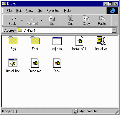
1. (d) You need to run the BAT file called Install.bat in the directory you used to unzip the software. The BAT file executes Arj.exe to extract the contents of the archive file called Install.arj.
Double click on the Install.bat icon in the window above with the left mouse button. Or use Start/Run... menu in Win95/8
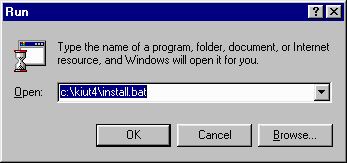 (You must specify the name you used for
your own temporary directory - if it is different to my example
here of c:\kiut4!
(You must specify the name you used for
your own temporary directory - if it is different to my example
here of c:\kiut4!
The installation creates a new subdirectory called C:\Kiut to hold the extracted files. You should now see the following "disc 1" extraction to C:\Kiut subdirectory

The installation halts with a question asking "OK to process next volume (1)?". The next volume is lemez (disc) 2 or kiut4d2.zip file which you have already unzipped in Step 1. (c) above.
All you have to do is Type 'y' and press the 'Enter' key to continue. The installation extracts the rest of the ARJ files.
1. (e) When the extraction and installation is finished you should see the following:-

Press any key to continue as asked, and the DOS install program terminates. You may now delete the temporary directory created in Step 1. (c) above.
You are ready to try out KIUT 4.0
Step 2. - A brief introduction to the use of KIUT 4.
Hopefully you completed Step 1 successfully. Now comes the hard part : learning to use this program. I can only give the briefest introduction to this complex program but enough of a guide to get you to start searching for place names on your own.
The installation will have created a C:\Kiut subdirectory. The program will add a shortcut to the Start/Programs menu after it has been run manually for the first time. Step 2. (a) and (b) are necessary the first time the program is executed. You won't be asked to specify your native language and fonts for subsequent runs of the program.
2. (a) To run the program Kiut.exe:- Double click My Computer icon (left mouse button) on your Win95 desktop and open the directory C:\KIUT to see the following

Double click on the Kiut.exe icon (left mouse button) to run the program for the first time and you should see this dialog box:-
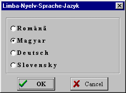 It asks you to select your native
language for menus. Sadly English is not one of them.
It asks you to select your native
language for menus. Sadly English is not one of them.
If you have a dictionary in one of these languages it is not hard to work out just what the menus say.
I will chose Magyar (Hungarian) here. Select OK to continue.
2. (b) Now you should be asked for the fonts to use:-
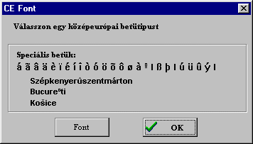 This screen is asking you to select a
font suitable for Central European languages. If you cannot
supply one or you are not sure of what to do, accept the default
by clicking on OK to
continue.
This screen is asking you to select a
font suitable for Central European languages. If you cannot
supply one or you are not sure of what to do, accept the default
by clicking on OK to
continue.
You can always reinstall the software and change fonts if you want to experiment.
2. (c) Steps 2. (a) and (b) will not be asked for in subsequent runs of this program. Whenever you run Kiut.exe you should see this welcome screen in Hungarian (or presumably in the language you chose) at startup:
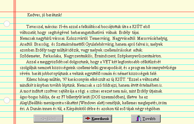
This screen details the development of the software and the reason for its existence: the fostering of greater cooperation between nationalities by offering the map in four languages (Rumanian, Hungarian, German and Slovakian).
The buttons from left to right are Elözö, Következö, Tovább mean Previous, Next, Continue.
The button Következö takes you to the next screen of this welcome page which has similar information as the web page.
Click on Tovább to continue.
2. (d) You should now see the main map area and two smaller windows labelled 'Látható rész' ( Viewing area) and 'Eszközök' (Tools)
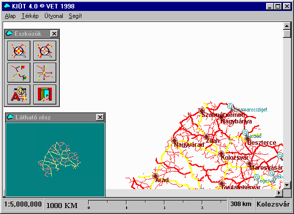
The 'Látható rész' ( Viewing area) window shows the roads in the region of interest which gives a general outline of the area. The region above known as Erdély (Transylvania) is recognisable in outline.
2. (e) The 'Eszközök'
(Tools) window briefly explained:
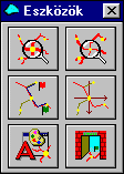 |
Zoom in | Zoom out |
| Roads | Search/ Set Centre |
|
| Setup/ Preferences |
Program Exit |
The options Zoom in/out are easy to use. Zooming in gives this map view of the map above:-

There is not much detail shown on the map because you need to set preferences first in Step 2. (f) below. The 'Látható rész' ( Viewing area) window reflects the region of interest (white shaded rectangle); notice how the rectangle shrinks as you zoom in.
Coarse manipulation of the Region of Interest
You can move the viewing area with the mouse to shift the point of interest, which is the white rectangle within the small window labelled 'Látható rész' above. Move your mouse over the white rectangle and the mouse pointer changes shape to four arrows. By holding the left mouse button down you can drag the white rectangle where you please. Releasing the mouse button automatically redraws the map at the new location without changing the Zoom scaling.
The Roads button will calculate shortest distances from one point to another when travelling in these regions. I have never used it.
2. (f) Click on the the Setup/Preferences button and you will see something like this

This 'Beállitásol - kiut.ini' or
setup window lets you select such things as
(i) the region of interest (Rumania, Hungary, Slovakia) under the
heading 'Látható régiók';
(ii) the language the towns and villages names will be displayed
in - Rumanian, Magyar (Hungarian), German or Slovakian using the
buttons under the heading of Nyelv (language);
(iii) the roads to be displayed (dirt, county, country, highways
etc.) using the Utak folder/option;
(iv) display villages, communities, small towns, cities using the
Helységek folder/option;
(v) set travelling/costs/petrol options using the Átlagok
option;
(vi) set starting and destination points of roads to display in
maps using the Útvonal option.
The other buttons are
Elfogadom = OK/I accept,
Mégsem = Cancel,
Ment = Save, (saves your ini file to a
file)
Beolvasás = Import (read in a new ini file from
somewhere).
2. (g) Having selected the region - Slovakia, Magyarország (Hungary) and/or Rumania you need to set whether you want villages, communities, small towns and cities to appear on the maps. Click once on the Helységek (places) folder just above the Elfogadom (OK/Accept) button, and you should see the following window. Put ticks on the places you want to see:-

Falu = village; Község = community; Kisváros = small town; Város = larger town; Nagyváros = city. The colours of the place names also give an indication of the type of place you are seeing - village, community small town and so oon.
These settings will be automatically saved upon exit of the program - you will not have to set them every time you run this program.
Click on Elfogadom/OK to set your options/choices or Mégsem/Cancel to go back.
2. (h) Once you are happy with the region and the places which will be displayed it is time to search for a location. In the 'Eszközök' (Tools) window, click on the Search/Set Centre button as shown in step 2. (e) above and you should see this window:-

Note: Sometimes the Hungarian village and community names have the old Hungarian county name added to the front by the software! In the window above see how KOLOZS (the old Hungarian county) appears as part of a village name. This is NOT always true for every name (e.g. Kolozsvár), nevertheless keep this in mind when searching for places.
The radio button called Összes displays all the place names in accordance with your preference settings. You can scroll through these names to find what is available - you would do this if you were unsure of the spelling for example.
Or you could perform an actually search through these names by clicking on the Szótag (syllable) option in the window. And if you do, the program clears the listed names and then expects you to type in a complete or partial name to search for.
The program will accept the different ethnic names of villages
and communities.
That is, if a village has/had a German/Slovak/Rumanian/Hungarian
name then you can search using that name.
Please note that accents and special characters must be specified correctly for the program to find a name. You can specify the accented letters by clicking on the list of letters under the Keres (Find) button:-

I have already typed SZUNYOG - (the search value). If you type an incomplete or partial name, the program may find several or many names with the search value as a substring.
You have to click on Keres (Find) to start the search. My search came back with these results:-
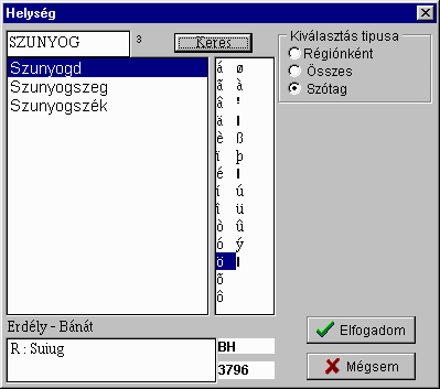
The display under 'Erdély - Bánát' above shows the other ethnic names the place may have.
Now, select a place by clicking once on a name in the list returned by the program, and then press Elfogadom/OK.
The program will then display the map centered on your selection. Remember that if your preferences are not set up correctly the map will be centered on your selection but the place may not be shown. You have to ask for villages if you want them to be displayed. The same can be said for communities, small towns, large towns and cities, roads and so on as you saw in step 2. (g) above.
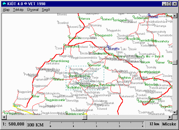
I selected Szunyogszék in the list and pressed Elfogadom/OK. Having zoomed in several times using the 'zoom in' button on the 'Eszközök' (Tools) window from step 2. (e) above, the map looks like this:-

Pretty useless because I did not ask for villages or communities. Going back to set my preferences properly by ticking 'Falu/village' and 'Község/community' in step 2. (g) the map now gives me this improved view:-

The colours of the place names denote the class of the place - village, community, small town, large town, city. In the map above, villages are in black/grey letters and communities are shown in green. You can use the windows scroll bars to pan around. You can zoom in or out.
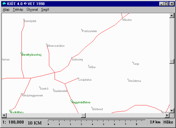
In Step 2. (e) above, you saw how to apply a coarse manipulation of the region of interest here is a related method which takes a bit of practice.
Fine manipulation of the Region of Interest
You can select a small area or rectangle of the map itself by pointing, holding down the left mouse button and dragging a small rectangle as in the next screen. The trick is to position the two diagonal lines of the dragged rectangle over a village so that the map will be displayed with the village as its centre; in this example the diagonal lines cross at the place of Höke which you can just make out on the map :-
Releasing the mouse button gives an enlarged view of the selected area with Höke as its centre as shown below :-
By double clicking (left mouse button) on a place on any map you get the Rumanian, Hungarian and German names in Erdély (Transylvania) whenever available. In Slovakia you get the original Hungarian name and the current Slovakian version. Something like the following is displayed:-
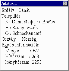 Adatok (Information/Data)
Erdély - Bánat (Transylvania - Banat
region)
Település: (Area or Settlement::)
R : Dumbraviza (Rumanian name)
H : Szunyogszék (Hungarian name)
G : Schnackendorf (German name)
Osztály : Község (Class : Community)
Egyéb információk: (Other
information: )
Megye : BV (County : BV = Brassov)
The other two bits of information refer to Callnumber and
Direction indicator?
Note:- Many of the historical counties of pre-1920 Hungary have
been amalgamated and renamed in Slovakia and Transylvania (Rumania).
For example, large parts of the historical Hungarian counties of
Bereg and Szatmár now lie in other countries. The modern
Hungarian county of Szabolcs-Szatmár-Bereg was formed from what
was left of the remains after 1920.
The community of Szunyogszék we found above was originally in the historical Hungarian county of Fogaras before 1920, which was combined with the old Hungarian county of Brassó to form the current Rumanian county of Brassov.
While this program gives us villages with the old (Hungarian, German) and new names (Slovakian, Rumanian), it will only give the modern counties in which you find those villages! So beware.
Steps 2. (a) and (b) are only applicable the very first time Kiut 4.0 is run. Preference settings are automatically saved by the program on exit.
Note:- upon exit from the program it will display two messages about having performed an illegal operation - the second is the usual:-

Acknowledge the warnings or report the bug. This has not caused me any problems. If you are worried about it power down and reload your machine.
Ronald McComb kindly brought to my attention that this does not occur in WIN98. He further suggests that the file MOUSE.COM should be renamed to MOUSE.CON (for example), so that it is not called/executed.
I hope this brief introduction to the use of Kiút 4.0 will provide a tool for finding places from which your ancestors may have come from in Slovakia, Hungary and parts of Rumania.
This guide is Copyleft © 2000,2001,2002,2003,2004
Updated 17 December 2003