Insider's Guide to Southern California Home Page
Other Sothern California Places to Visit
Visit our new Bookstore!
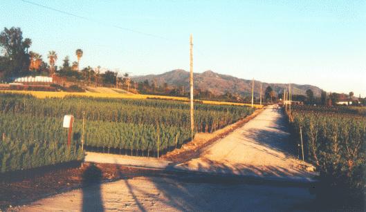
This bucolic scene in Azusa will soon cease to exist.
Los Angeles County has not always been the megalopolis it is now. Heck, I can remember living across the street from a dairy farm when I was growing up. Beyond that was a grain & feed depot and then a seed farm. Now that area is filled with factories and a hospital...although the grain & feed store is still in business there.
Amazingly though, there is still agriculture in L.A. County. It's quickly being gobbled up by development, but there is still some left remind you of L.A's rural past. In fact, there is still over 130,000 acres in agricultural here in Los Angeles County...most of that in Antelope Valley to the north. Closer in by the city, it's much harder to find, but it's still there...for now.
Monrovia Nursery
The number 1 agricultural business in the L.A. area these days is nursery crops. In fact, the world's largest nursery is here-but not for much longer.
A drive along Sierra Madre Avenue from Azusa to Glendora reveals hundreds of acres of growing grounds belonging to Monrovia Nursery. There are over 500 acres here still being farmed. Unfortunately, if you want to see this large remnant of L.A.'s rural past, you'd better hurry.
Recently, the Azusa City Council approved a development plan that would replace the nursery with over 1,600 homes. Within a couple of years, the nursery will be history in L.A. They are moving all operations up to Oregon.
It's an amazing sight for L.A., driving along a suburban street with 25 mile views unblocked by buildings. This is one of the last big parcels left and now it's fallen victim to high land prices and development pressures.
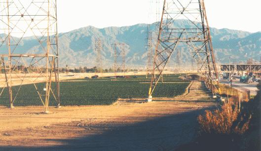
Strawberries grow alongside the freeway
Much more common in L.A. is undevelopable land being used for farms. This is land that is under high-tension wires, in flood control area, or other unusable land. The two big crops here are, again, nursery stock, and strawberries.
Above, you can see one such strawberry field growing in the strip of land that carries power lines between the 605 freeway and the San Gabriel River (For you out-of-town folks, yes...that's what our rivers usually look like, dry and full of weeds).
Strawberries are still big here, however most of our local crop is shipped back east where early berries command high prices. Most of what we get in our local stores and farmer's markets are grown up north in Watsonville and Oxnard with later season berries being shipped up from Mexico.
One unique farm to use this land can be seen from the 10 (San Bernadino) freeway in Rosemead between the Walnut Grove and San Gabriel exits. That is Lyon's Christmas Tree Farm where trees are grown all year for do-it-yourself harvest during the Christmas season.
For more traditional rural life, many citizens of Bradbury-a small enclave nestled up against the San Gabriel Mountains just north of Duarte-raise racehorses and avacados for profit.
You won't see much of it if you try, though. Most of the city is behind locked & guarded gates keeping you & me out. You can see a charming little miniature horse farm if you come in on Lemon Ave. Off of Mountain Ave. just north of the 210 freeway in Monrovia, you can head east on Lemon up to the top of the hill. On you right will be a farm with the littlest horses you've ever seen.
Climbing over the pass to Orange County on the 57 freeway, suddenly you will be in a spot with no more houses. At 70 miles an hour, they're easy to miss but you could swear you've been transported to Texas and just saw a herd of longhorn cattle.
You're okay, you've just passed through a remnant of the Diamond Bar ranch which has mostly been converted to the city of Diamond Bar. Yes, those are longhorn cattle munching contentedly on the hillside and, yes, this still is a working cattle ranch.
How this land has escaped development is hard to say, maybe it's the working oil wells nearby or just luck that this beautiful greenbelt still exists to separate Orange and Los Angeles Counties up here in the Puente Hills. To get a slower glimpse, get off the 57 freeway and climb over the pass on Brea Canyon Road instead.
Perhaps the best example of rural L.A., and the most likely to survive in the long run, is the very productive lands of the campus of the California Polytechnic University in Pomona, better known as Cal Poly Pomona.
Here, you can see...and better yet wander through...hundreds of acres of farmland devoted to many crops. Citrus, alfalfa, arabian horses, cows, pigs, and chickens are some of the many crops and animals raised as part of this university's School of Agriculture. You can also buy the results of this farming at one of several shops on the campus.
If you happen to stop by on the second Sunday of the month, you can also see the famous arabian horse show in the school's exhibition ring.
As you can see, a very little remains of L.A.'s storied agricultural past. Land prices rise and owners can no longer resist the lure to cash in. People continue to move here creating more pressure to build even more housing. It's amazing that there's anything left at all.
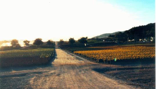
One of these orange trees is the mother of an entire industry
Beyond L.A. you can still find the countryside. In Antelope Valley, west of Palmdale and Lancaster, many fruit orchards dot the hillsides and several vineyards flourish. For those looking to find California's famous orange groves, a citrus best still exists in the Ventura County corridor from Valencia to Santa Paula. Those interested in history will want to see the parent navel orange tree in Riverside which spawned every navel orange tree in California at the corner of Arlington and Magnolia.
This is truly a rapidly vanishing part of Southern California history that needs to be seen soon before is disappears completely.