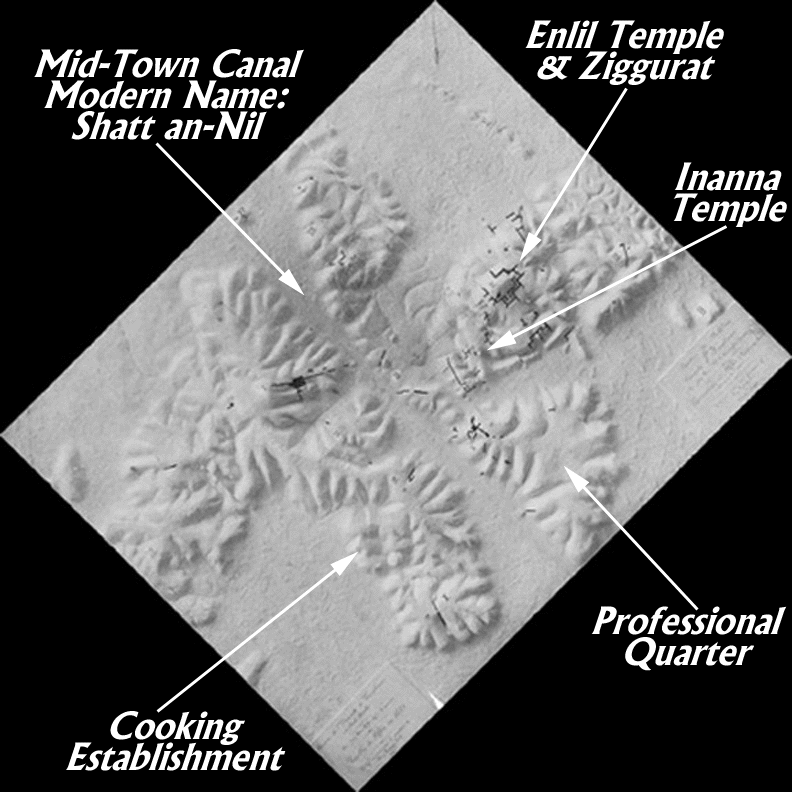
A photograph of this relief map is shown here with several significant features marked by arrows. Cursor down below for an explanation of these features.
A prominent feature of the layout of ancient Nippur was the Midtown Canal which flowed through the middle of the city. Another branch of the Euphrates River flowed around the western side of town. The deep trough marking the original bed of the Midtown Canal is now called the Shatt an-Nil. The two waterways were very valuable for transportation purposes. The storehouses of the major temples on the city's east side were quite close to the bank of the Midtown Canal. Pilgrims and donations could easily make their way into the temples through the strategically located Canal. From the two branches of the River, critically needed water for agricultural purposes could be led by a complex irrigation canal system out to the grain fields and date orchards.
The Midtown Canal divided Nippur into clearly-defined eastern and western sectors. The largest of the public buildings were located on the eastern side of the Canal in an area called Duranki, "the bond of heaven and earth". These buildings were erected for the honor and worship of the major divine powers venerated at ancient Nippur. We have marked the area devoted to the worship of the great god Enlil, whose favor was a very valuable asset for aspiring kings asserting their divinely-bestowed right to rule the region. Enlil was considered the bestower of kingship.
On the southwest side of the temple of Enlil stood a massive ziggurat (Sumerian unir), a stepped tower rising originally in three stages to a shrine at the top of the final stage for the worship of the great god. This large structure was the work of Ur-Nammu (2112-2095 B.C.), founder of the powerful dynasty of kings ruling over Sumer and Akkad from the down-river city of Ur during the twenty-first century B.C. Construction work for the Enlil temple had been carried out earlier by the Akkadian kings Naram-Sin (2254-2218 B.C.) and Shar-kali-sharri (2217-2193 B.C.), but credit for the construction of the mighty ziggurat belongs to Ur-Nammu.
The base of the ziggurat was rectangular, measuring 39 by 58 meters, thus covering 2262 square meters (over 23,000 square feet). The first stage was about 6 meters (almost 20 feet) high, with the sides sloping back at the rate of one in four. The second stage was set in from the first about 4 meters (about 13 feet).
In the time of King Ur-Nammu, the pavement on which Enlil's temple rested was itself 11 meters (about 36 feet) above the level of the surrounding plain outside the city. The much-higher shrine on top of the ziggurat must have been visible for miles around. A staircase on the southeastern side of the ziggurat provided access to the high shrine. Staircases were also constructed on the northeast and southwest sides.
Just to the southwest of the Enlil complex was another large temple, this one devoted to the worship of the great goddess Inanna. Her temple was situated very close to the Mid-Town Canal. This significant building covered 6,000 square meters (over 64,000 square feet, well over an acre). It was not designed to accommodate large crowds in one place, but was divided into numerous rooms and courtyards for both ritual and administrative activities involved in the worship of a great deity. This temple was built by King Shulgi (2094-2047 B.C.), son and successor of Ur-Nammu. Nearby was another major temple complex devoted to the god Ninurta, but we have not yet been able to define its exact location.
To the southeast of Duranki, the temple area, was a large triangular area of land which we can designate as the Professional Quarter (called Tablet Hill by some of the excavators). Temple administrators and ritual functionaries lived and worked in this section of the city. Although they carried out some of their duties to the northwest in Duranki, they kept records and did some work here. It was hard back then to separate business and personal affairs just as it is for some professionals in our own day.
Unfortunately, we know less about the west side of the city than we do about the east side. The present ruins of Nippur are quite extensive and only a small part has actually been excavated. We are aware of a food establishment located on the west side. This area is marked on the map above. Two buildings were found that housed the processing of large amounts of barley into bread as well as the brewing of beer. The one building was a well-designed and well-built rectangular structure covering an area of 250 square meters (almost 2700 square feet) and consisting of eleven rooms built around two courtyards. A residential section also existed south of the area just described. The houses there were destroyed in a fire.
For more material on the ancient Sumerians and the sacred city of Nippur, visit Dubsar the Cuneiform Scribe at Fortune City or the domain now owned by Dubsar and Anshe at the Nippur Quay, a wonderful Bronze Age Business District.