

Posted on February 15, 1999
By : Soetrisno S.
HYDROLOGIC CYCLE
Groundwater is one portion of the earth's water. Water in its various form always moving in natural circulation system, known as the hydrologic cycle (Fig. 1).
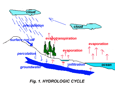
Seawater because of sun's heat evaporates to the air, and by the wind it's blown to the above of land. In a high elevation place, these vapor will be compacted and when its saturation point is exceeded, its falls again to the earth as rain water. Most part of rain water flows at surface as surface water, such as rivers, lakes, or swamps. A small portion of rain water infiltrates into soil and percolates to reach saturated zone and becoming groundwater. Part of water which infiltrates near surface will evaporate again through plants (evapotranspiration). Direct evaporation lasts on opened water body, whilst surface run-off will eventually gather back to the sea, and hydrological process as mentioned above, will last over and over again.
Hydrogeology may be defined as the science of the occurrence, distribution and movement of water below the surface of the earth, with emphasis on geology.
GROUNDWATER OCCURRENCE
Groundwater is part of water below surface (sub-surface water), in zone of saturation (Fig. 2). Vertical distribution of sub-surface water may be divided into zone of aeration and saturated zone. Zone of aeration comprises of interstices which are partly occupied with water and air, while all interstices in saturated zone is filled only with water.
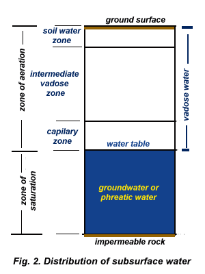
Water fills in zone of aeration is called as vadose water. Vadose water which occurs near surface and available for roots of vegetation is difined as solumn water, while capillary water is the water occupies capillary zone.
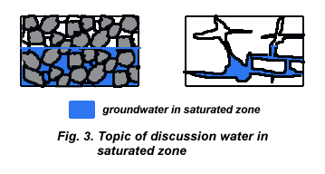
Next, topic of discussion will only water which occupied zone of saturation. Groundwater occurence in saturated zone filled in all rock interstices or fissures (Fig. 3).
The rocks itself, referring to its water property, may be divided into :
Aquifer : is a formation that contains sufficient saturated permeable material to yield significant quantities of water to wells or springs. This implies an ability to store and transmit water. Unconsolidated sands and gravels are a typical example.
Synonyms frequently employed include: water bearing formation and groundwater reservoir.
Aquiclude: a saturated but relatively impermeable material that does not yield appreciable quantities of water to wells. Clay is an example.
Aquifuge : a relatively impermeable formation neither containing nor transmitting water; solid granite belongs in this category.
Aquitard: a saturated but poorly permeable stratum that impedes groundwater movement and does not yield water freely to wells, but that may transmit appreciable water to or from adjacent aquifers and, where sufficiently thick, may constitute an important groundwater storage zone; sandy clay is an example.
Aquifer's Lithology
Water property of aquifer as mentioned above, is an important rock formation in groundwater abstraction effort.
Lithology or rocks composition of main aquifers in Indonesia may be described as follows :
Alluvial deposits: are deposits which are derived as a result of erosion process from older rocks. These deposits comprise of unconsolidated materials, such as sand and gravel. Groundwater occupied rock interstices, and distributed over flat or plain areas.
Young volcanic deposits: are deposits of volcanic product, consist of unconsolidated and consolidated materials. Groundwater fills in either interstices of unconsolidated materials or fissures of consolidated rocks. These deposits are distributed adjacent to volcano areas.
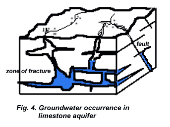
Limestone: is originally marine deposit with carbonate contents, which due to geologic process is being uplifted to the surface. Here, groundwater occurred in fissures, cavities and solution channels (Fig. 4). This rock crops out in areas where formerly were sea. Owing to geologic, physic and chemical processes, in several areas it formed a particular morphology, known as karst.
PERMEABILITY and TRANSMISSIVITY
The permeability
of rock or soil defines its ability to transmit a fluid.
For practical work in groundwater hydrology, where water is the
prevailing fluid, hydraulic conductivity = K is employed.
A medium has a unit hydraulic conductivity
if it will transmit in unit time a unit volume of groundwater
at the prevailing kinematic viscosity through a cross section of unit area measured at right angels of direction of flow under a unit hydraulic gradient (dh/dl).
where v = velocity of specific discharge (the negative sign indicates that the flow of water is in the direction of decresing head).
Hydraulic conductivity of geologic materials depends on avariety of physical factors including porosity, particle size and distribution, shape of partcles, arrangement of particles, and other factors. A rock formation has hydraulic conductivity K and saturated thickness b, then it has transmissivity coefficient, T, :
Transmissivity may be defined as the rate at which water of prevailing kinematic viscosity is transmitted through a unit width of aquifer under a unit hydraulic gradient. The more higher value of T is meant that lithology of rock is an aquifer with high potential groundwater.
TYPES of AQUIFERS
There are various types of aquifers :
Unconfined aquifer is a water bearing layer where its water table is upper boundary of aquifer itself.
Groundwater in this aquifer type is called as unconfined of free groundwater, since water pressure is equal to air pressure (Fig. 5).
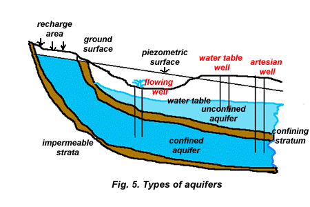
Confined aquifer): is a water bearing layer, where groundwater is confined under impermeable strata, both at its upper and basement. Water level lies higher than the upper part of aquifer (Fig. 5).
Water level, in this case is called as piezometric, may be at above or below surface. If piezometric head lies above surface, then a well which taps this type of aquifer flowing freely its groundwater to the surface. Groundwater in a such condition is known as artois or artesian.
Based on its confining layer, confined aquifer may be distinguished to semi-confined aquifer) or fully confined.
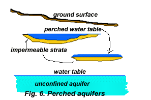
Perched aquifer: a special case occurs wherever a groundwater body is separated from the main groundwater by a relatively impermeable stratum of small areal extend, and lying above the main groundwater table (Fig. 6).
GROUNDWATER FLOW
Some factors influence to the movement of water below surface, which among other are :
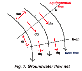
Groundwater need an energy to move through interstices. The source of movement is a potential energy. The potential energy of groundwater is reflected by phreatic/piezometric head at given place. Groundwater flowing from higher potential energy points towards lower potential energy points; there are no groundwater flows between points which have same potential energy.
Imaginear line connecting points wich have same potential energy is known as groundwater contour line or isohypse lain. There is no groundwater flows along the contour line since groundwater flows is pependicular to contour line (Fig.
7).
Groundwater flow generally moves from recharge to discharge area and might appear to the surface due to various factors.
GROUNDWATER APPEARING
Groundwater may appear naturally to the surface as a spring or because of man activity through wells.
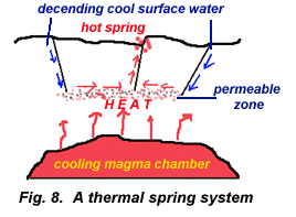
A spring is a concentrated discharge of groundwater appearing at the ground surface as a current of flowing water. Referring to its cause of appearing, springs may be divided into two categories (Bryan vide Todd, 1980), which are:
Under the former category are included springs, resulting from fractures extending to great depths in the earth's crust. Such springs are usually thermal (Fig. 8).
Gravity springs result from water flowing under hydrostatic pressure. The following general types are recognized (Fig. 9):
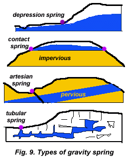
Depression springs formed where ground surface intersects the water table.
Contact springs created by a permeable water-bearing formation overlying a less permeable formation that intersects the ground surface.
Artesian spring resulting from releases of water under pressure from confined aquifers either at an outcrop of the aquifer or through an opening in the confining bed.
Tubular or fracture springs issuing from rounded channels, such as lava tubes or solution channels or fractures in impermeable rock connecting with groundwater.
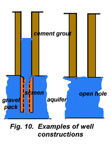
Groundwater appearing to the surface resulting from man's activity may be conducted with fully penetrated or partially penetrated to the aquifer's thickness.
Construction of well depends on aquifer's properties and quality of groundwater. Therefore, there are various types of well constructions (Fig. 10).
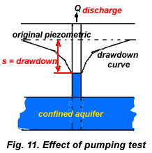
To know about the discharge of well, pumping test should be conducted. Its principles are to pump out groundwater from a well with a certain constant discharge and observe drawdown of groundwater level during pumping (Fig. 11). From the result of observation specific capacity of well are known - a volume of water which is resulted, in a unit volume if water level in well is declining in a unit length (for example liter/second per meter drawdown). Apart from that, pumping test may calculate aquifer's parameters such as hydraulic conductivity value.
Groundwater drawdown in a single well is different with drawdown of multiple wells. Drawdown in multiple wells will influence between each other, depends on wells distance (Fig.12).
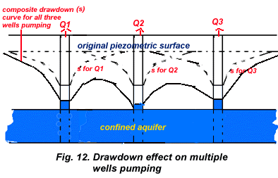
In an area where many wells tap the groundwater from the same quifer, pumping will form a cone of depression. If it is happened in a coastal area, sea water encroachment may be occurred, - brackish or saline water flows to the land. Mean while, if this condition lasted in a confined aquifer with clay layer as its confining bed, a land subsidence is potentially occurred.
QUALITY of GROUNDWATER
Since groundwater is occurred in recharge area and flows to discharge area through
interstices of rock forming aquifer, groundwater may solute rock's minerals and may be influenced by its environment. Therefore,
groundwater quality is different and vary from one place to another, depends on where groundwater infiltrates, moves, accumulates, and environment conditions.
Quality of groundwater is expressed in physical property, chemical constituent and bacteriologic contents.
Groundwater quality condition has been standardized based on its usage, such as water quality for drinking, irrigation or industry.
Several mayor constituents of groundwater
- 1,0 to 1000 mg/l - are sodium, calsium, magnesium, bikarbonate, sulphate, dan chloride. High content of chloride may indicate pollution derived from waste water or sea water intrusion.
While nitrate content as secondary constituents - 0,01 to 10 mg/l - may derive from anthropogenous waste, vegetations and fertilizers.
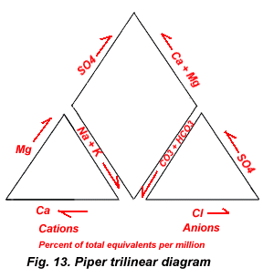
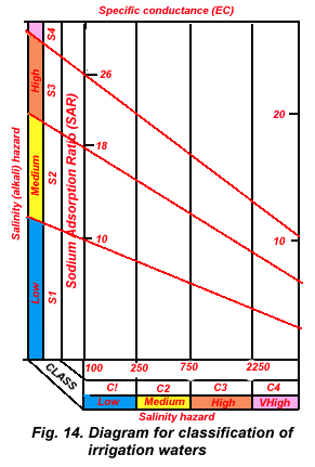
To present result of groundwater chemical analysis, is usually used Piper trilinear diagram (Fig. 13). With this diagram , most dominant constituents in groundwater are to be known. Whereas Sodium Adsorption Ratio (SAR) diagram presentation is very common used for analysing of groundwater for agricultural purpose (Fig. 14).
FOOT NOTE
The word vadose is derived from the Latin vadosus (shallow).
The word aquifer can be traced to its Latin origin. Aqui is a combining form of aqua (water) and -fer comes from ferre (to bear). Hence an aquifer is a water bearer. The suffix -clude of aquiclude is derived from Latin claudere (to shut or close). Similarly, the suffix -fuge of aquifuge comes from fugere (to drive away), while the suffix -tard of aquitard follows from the Latin tardus (slow).
The word artesis/artois is derived from the French artesien meaning "of or pertaining to Artois", the northernmost province of French. Here the first deep wells to tap confined aquifers were drilled and investigated, from about 1750. Originally the term referred to a well with freely flowing water, but at present it is applied to any well penetrating a confined aquifer or simply the aquifer itself.