-
When rocks deform like toothpaste, changing shape irreversibly, it is called (a)
brittle deformation (b) elastic deformation (c) gelatinous deformation (d)
plastic deformation
-
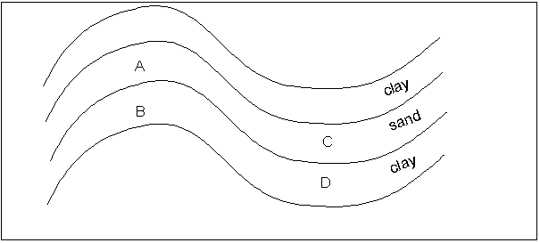
If layers of sedimentary rocks are folded in the shape below, in which of the
labelled spots is oil most likely to accumulate? (a) A (b) B (c) C (d)
D
-
If you were driving through the Valley and Ridge Province of the Appalachian
Mountains, stopped, and climbed to the top of a ridge, which of the following
rocks would you be more likely to find on the top of the ridge? (a) gypsum (b)
limestone (c) sandstone (d) shale
-
The Alps, Himalayas, Urals, Appalachian Mountains are all examples of (a)
fault-block mountains (b) Fold-and-thrust mountains (c) upwarped mountains (d)
volcanoes
-
Which of these mountain chains is the oldest? (a) Alps (b) Appalachians (c)
Himalayas (d) Rockies
-
The fault-block mountains of the Basin and Range province are bounded by which
type of fault? (a) high-angle normal fault (b) high-angle reverse fault (c)
low-angle thrust fault (d) strike-slip fault
-
P waves travel faster than S waves. This fact enables us to determine (a)
that the outer core is liquid (b) that the aesthenosphere exists (c) the
distance to the epicenter of an earthquake (d) the magnitude of an earthquake
-
The reason that earthquakes seldom have a focus deeper that 60 miles below the
Earth's surface is that below 60 miles depth, (a) all rocks have melted (b)
rocks deform plastically (c) seismic waves cannot penetrate (d) S waves
cannot travel
-
Along the western side of South America, the focus of earthquakes
(a) gets deeper toward the interior of the continent (b) gets shallower
toward the interior of the continent (c) is deep for all earthquakes (d) is
shallow for all earthquakes
-
Which of the following is not true about the New Madrid earthquakes? (a)
Another earthquake is likely to occur. (b) A possible cause is a continental
hotspot. (c) A possible cause is old fractures from plate rifting. (d) A
possible cause is that erosion removes sufficient material for the continental
crust to rebound, creating stress. (e) A possible cause is that the loading of
sediment deposition weighs down the crust, creating stress.
-
Fault segments that are locked in place and thus likely spots for future
earthquakes are called (a) bulges (b) seismic gaps (c) stratigraphic
evidence (d) transform faults
-
The mantle accounts for 80% of the Earth's volume. The core accounts for one-third
of the Earth's mass. This tells us that (a) the core is denser than the
mantle (b) 80% plus one-third is less than or equal to one. (c) the outer
core is liquid (d) the inner core is liquid
-
Which of the following did Benjamin Franklin not do? (a) father multiple
children (b) hypothesize that the earth had a solid crust over a fluid
interior (c) hypothesize that the occurrence of coal in Norway was evidence of
ancient climatic differences (d) perform experiments with lightning and
electricity (e) serve as ambassador to France
-
Which of the following is not used for determining plate velocity? (a)
the difference in velocity between P and S waves (b) plate movement over
oceanic hot spots (c) satellite tracking (d) tracking magnetic-field
reversals
-
Which of the following is not true about the Ural Mountains in Eurasia? (a)
They formed from the collision of two continents. (b) They mark the place
where Europe and Asia were sutured together. (c) They separate Europe and Asia.
(d) They were formed from volcanic activity along a subduction zone.
-
The oldest part of a continent, formed of crystalline rock, is (a) the coastal
mountains (b) the continental platform (c) the continental shelves (d) the
continental shield
-
In the earliest years of the Earth's formation which of the following was not
true? (a) eruptions from the mantle formed the beginnings of the atmosphere
and oceans (b) felsic and mafic rocks were differentiated by partial melting (c)
the continents were surrounded by subduction zones (d) the first land masses
were probably huge volcanic islands (e) the mantle was hotter than now
-
Which of the following is not a likely mechanism for creating plate
movement? (a) convection cells (b) gravity-driven plate sliding (c)
movement induced by the Earth's rotation (d) thermal plumes (e) wedging
apart of oceanic plates by magma at the mid-oceanic spreading centers
-
Which of the following processes is not a natural way in which slopes are
steepened? (a) coastal waves (b) roadcuts (c) stream undercutting of banks
(d) tectonic activity (e) volcanic eruptions
-
Deforestation can lead to all of the following except (a) decreased
infiltration (b) increased flooding (c) increased ground-water recharge (d)
soil loss
-
In the loess example from Vicksburg, MS, the loess lost its strength and
collapsed (a) because it was cut at too steep a slope (b) because it was
kept wet (c) because of an earthquake (d) because of the 1927 flood
-
During and after the Gros Ventre Slide, which of the following did not
happen? (a) 6 people drowned when the natural dam was breached (b) 17
people were killed by the slide (c) a lake formed behind the slide debris (d)
the slide travelled so fast that it went part of the way up the other side of
the valley
-
Semi-circular crescent-shaped detachment scars are indicative of which of the
following types of mass movement? (a) fall (b) creep (c) slide (d) slump
(e) solifluction
-
For the construction of the Trans-Alaska Pipeline, which of the following was not
a concern? (a) environmental impacts (b) the effect of hot oil in a pipeline
laid through permafrost (c) solifluction (d) migration of animal herds (e)
drilling for oil in the Arctic National Wildlife Refuge
-
Where is most of the world's fresh water stored? (a) glaciers (b)
groundwater (c) oceans (d) streams
-
Where Metarie Ridge, Gentilly Ridge, and Bayou Sauvage are now located was once
located which of the following? (a) distributary channel of the Mississippi
River (b) a drainage divide between the Mississippi River and the Pearl River
(c) tributary of the Mississippi River (d) a canal for improving
transportation of goods from across Lake Pontchartrain
-
The maximum discharge that the Corps of Engineers allows past New Orleans is 1,250,000
cubic feet per second. If discharge is in danger of exceeding this, the Corps
responds first by (a) blowing up the levee south of New Orleans (b) opening
the Bonnet Carre' Spillway (c) opening the Old River Control Structure (d)
diverting water down the Atchafalaya River
-
When folded rocks of differing resistances to weathering erode, the drainage
pattern likely to form on top of them is called (a) dendritic (b) radial (c)
rectangular (d) trellis
-
Which of the following is not a way in which the sediment load of a
stream may be increased? (a) melting of glaciers (b) placing of rip-rap on
the cutbanks of meandering streams (c) tectonic uplift (d) uplift due to
rebound from the weight of continental glaciers
-
As a delta grows out from the coast into deeper water, which of the following
sequences of material is most likely to result? (a) sand deposited over clay (b)
clay deposited over sand
-
Flood damage is made worse by all of the following except (a)
deforestation (b) increased groundwater infiltration (c) increased
population on floodplains (d) poor agricultural practices (e) urbanization
When answering the following questions, choose a for True and b for False.
-
Normal faults are normally the result of tension, not compression.
-
On the Richter scale, an earthquake of size 8 is twice as powerful as an
earthquake of size 4.
-
In the 1906 San Francisco earthquake, most of the damage was due to a large
tsunami that hit the city.
-
S waves travel through liquids but P waves do not.
-
The continental crust is thicker than the oceanic crust.
-
Alfred Wegener's Theory of Plate tectonics was initially rejected because of a
lack of evidence for how the plates could have fit together.
-
The Rift Valley in Kenya is an example of an aulacogen.
-
The Gulf of Mexico was formed as Pangaea began to break apart.
-
A landslide may sometimes move uphill.
-
A stream's stage is a measure of how well its meanders are developed, such as
young stage and mature stage.
-
The depth to which the bottom of the Mississippi River can erode is limited to
be above sea level.
-
Landforms on Mars are characteristic of flowing water, but there is no flowing
water currently on Mars.
The following questions are about slides that I will show during the test.
-
The feature that I will point to in the slide shown is (a) an expansion joint
in the highway overpass (b) a fault created by the earthquake (c) a fracture
created by subsidence (d) a weak spot in the concrete
-
The point identified by the arrow in the slide represents all of the following except
(a) a rift valley (b) an aulacogen (c) the future location of the Gulf of
Mexico (d) the future location of the Mississippi River
-
The black lines that I will point to represent (a) normal faults (b) oil
reservoirs (c) reverse faults (d) underwater valleys
-
The gates in the slide shown control (a) the volume of water from the
Atchafalaya River allowed to go down the Mississippi River (b) the volume of
water from the Mississippi River allowed to go down the Atchafalaya River (c)
the volume of water from the Mississippi River allowed to go down the Red River
(d) the volume of water from the Red River allowed to go down the Mississippi
River
-
The stones in the slide shown are intended to (a) prevent a point bar from
eroding (b) prevent a cutbank from eroding (c) prevent a mid-channel bar
from eroding (d) provide a good fishing spot
-
The explosion shown was related to all of the following except (a) an
agreement between the wealthy of New Orleans and the Governor of Louisiana (b)
improvement in the political prospects of Herbert Hoover (c) the 1927 flood (d)
the opening of the Bonnet Carre Spillway to send flood waters into Lake
Pontchartrain (e) the rise to power of Huey P. Long
-
In the photo shown, in which of the colored areas is subsidence likely to be the
least? (a) green (b) red (c) yellow