The Wonders of Peru


"We can assure your majesty that it is so beautiful and has such fine buildings that it would even be remarkable in Spain. ---Francisco Pizarro, describing Cuzco in a letter to King Charles V of Spain..."


"The Inca city in the sky":
Location, Geography & Climate

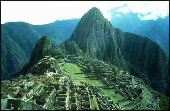
Peru is South America's third largest country, covering 1,285,215 sq. km., and can be divided into three distinct geographic regions. The best known of these is the central high sierra of the Andes, with its massive peaks, steep canyons, and extraordinary pre-Columbian archaeological sites. The Andes are still one of the world's most unstable mountain ranges, with frequent earthquakes, landslides, and flash floods. Despite such instability, the Andes are also the site of the most fascinating pre-Columbian cities of South America--like the great city of the clouds, Machu Picchu.

The Andes are by no means the only region to visit in Peru. Also of great interest is Peru's narrow, lowland coastal region, a northern extension of the Atacama Desert. Although the Atacama is generally known as the most arid region on the planet, the climate along Peru's shores is made cooler and less dry by La Garu�a, a dense fog created by the collision of the frigid waters of the Humboldt Current with the heated sands of the Atacama. Lima, Trujillo, and Chiclayo, three of Peru's major population centres, are located along this coastal desert.

Peru's third great region is the dense forest that surrounds the headwaters of the Amazon beneath the eastern slopes of the Andes. This part of the country is so inaccessible that only the most adventurous and intrepid travellers should attempt to penetrate its mysterious emerald depths. In fact, the region's capital of Iquitos, a city of 400,000, is accessible only by air or by boat up the Amazon.

Peru's climate varies considerably by region, although January through March tends everywhere to be the wet season. The coastal areas, which are quite hot and humid during those months, are cooled during the rest of the year by La Garu�a. The fog doesn't penetrate very far inland, however, and the western side of the Andes are very clear, warm, and dry for the greater part of the year. As one moves up into the mountains, night-time temperatures become considerably colder. The eastern slope of the Andes, like the Amazon basin, experiences very heavy rainfall during the wet season, which extends from January all the way through April.

"A native Peruvian":
History & People

Peru is best known as the heart of the Inca empire, but it was home to many diverse indigenous cultures long before the Incas arrived. Although there is evidence of human habitation in Peru as long ago as the eighth millennium BC , there is little evidence of organized village life until about 2500 BC. It was at about this time that climatic changes in the coastal regions prompted Peru's early inhabitants to move toward the more fertile interior river valleys. For the next 1500 years, Peruvian civilization developed into a number of organized cultures, including the Chav�n and the Sech�n. The Chav�n are best known for their stylized religious iconography, which included striking figurative depictions of various animals (the jaguar in particular) and which exercised considerable influence over the entire coastal region. The Sech�n are remembered more for their military hegemony than for their cultural achievement.

The decline of the Chav�n and Sech�n cultures around the 5th century BC gave rise to a number of distinctive regional cultures. Some of these, including the Saliner and the Paracas, are celebrated for artistic and technological advances such as kiln-fired ceramics and sophisticated weaving techniques. From the Paracas arose the Nazca, whose legacy includes the immense and cryptic Nazca Lines. However, the accomplishments of these and other early Peruvian civilizations seem today to pale in comparison to the robust pre-Columbian civilization of the Inca.

The most startling feature of the great Inca empire was its brevity. In 1430, the realm of the Inca consisted of little more than the river valley around Cuzco. Less than a century later, through conquest and a canny policy of incorporating the best features of the societies they subjugated, the Incas controlled a vast territory of almost 1 million square kilometers--a dominion that extended from northwest Argentina to southern Colombia. The Incan capital, at Qosqo, was undoubtedly the richest city in all of the Americas, with temples literally sheathed in heavy gold plate. Although Qosqo's architecture remains only in fragments and foundations, the architectural accomplishment of the Inca's has survived intact at the astounding ceremonial centre of Machu Picchu.

In 1532, at the height of its power, the Inca empire was driven by a war of succession. In one of the great tragedies of history, it was at precisely this moment that Francisco Pizarro and his band of Spanish conquistadors arrived on the scene. Showing an uncanny ability to turn circumstances to his own advantage, Pizarro used deception and guile to gain a personal meeting with Atahualpa, the Inca ruler, whom he coolly assassinated. In the face of fierce resistance, Pizarro and his men seized Cuzco and sacked the city. Although the Incas continued to fight for the next several years, their empire had ended and Spanish rule had begun.

Peru's population of about 23 million is divided almost equally between the highlands and the population centres of the coast, and the division marks a sharp cultural as well as geographic divide. The inland regions are marked by extreme poverty and subsistence agriculture, while the fertile river valleys of the lowlands have produced a wealthier, more cosmopolitan culture. Almost half of Peru's people are Indian, while another one third or so are mestizo. About ten percent are of European descent, and there are significant African and Asian minorities. Although Spanish is Peru's official language, a multitude of indigenous languages continue to hold sway in the highlands.

Hosted by www.Geocities.ws


back 1