All figures are 1991 census
figures unless otherwise mentioned. The next census is scheduled for
March 1, 2001.
 Population: 68,077,965 (1991 census final figures) ;
1998 estimates : 78.1 million. Population: 68,077,965 (1991 census final figures) ;
1998 estimates : 78.1 million.
Male:
35,510,633 (52.16%)
Female: 32,567,332 (47.84%)
Scheduled Castes: 16,080,611 (23.62%)
Scheduled Tribes: 3,808,760 (5.5%)
Population Density: 767 per sq. km.
Birth Rate (per 1000): 22.8 (1996 est.)
Death Rate (per 1000): 7.8 (1996 est.)
Infant Mortality Rate (per 1000): 55 (1996 est.)
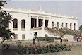
Picture: the crowds at important religious
functions often run into thousands. Managing a large and growing
population is one of the challenges of modern India.
 Working
population : 20.6 million Working
population : 20.6 million
Population engaged in agriculture sector: 11.6 million
Industrial workforce: 2.5 million
(source WBIDC).
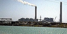
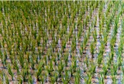 Pictures: West Bengal's
economy: From paddy fields to power plants, . West
Bengal is the largest producer of rice in the country and is also one of
the few Indian states where the power situation has improved for the
better. Pictures: West Bengal's
economy: From paddy fields to power plants, . West
Bengal is the largest producer of rice in the country and is also one of
the few Indian states where the power situation has improved for the
better.
 No
of Districts: 19 No
of Districts: 19
District having highest population: Midnapore
District having lowest population: Darjeeling
District having highest population density: Calcutta
District having lowest population density: Darjeeling.
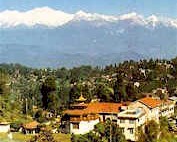
Picture: The majestic Himalayan ranges form the backdrop of
Darjeeling town.
 No
of Villages: 37,910 No
of Villages: 37,910
Urban Population: 18,708,000 (23.62%)
No of statutory towns: 116
No of census towns: 266
No. of Towns with over 100,000 population: 40
Major urban agglomerations: Calcutta - Howrah; Asansol - Durgapur.
Population of Greater Calcutta: 10,916,000
Picture: Calcutta is always busy. Without the
crowds, Calcutta will be a dull and lifeless city.
 Principal Languages: Bengali (86%), Hindi (6.6%), Urdu (2.1%),
Nepali. Principal Languages: Bengali (86%), Hindi (6.6%), Urdu (2.1%),
Nepali.
Literacy: 57.7% (Male: 67.81%; Female: 46.56%)
Religions: Hindus (74.7%), Muslims (23.6%), Christians
(0.6%), Jains, Buddhists, Sikhs, Zoroastrians.
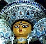
Picture: The Durga Puja festival is the biggest
festival in West Bengal.
Recommended Site: censusindia
|
 West Bengal is one of
the constituent states of the Republic of India. West Bengal is situated in a strategic position in eastern
India and lies between 21o31'
and 27o14' North Latitudes and between 86o35'
and 89o53' East Longitude. The Tropic of
Cancer passes through the state. The state extends from the snow clad
Himalayas in the north to the Bay of Bengal in the south.
West Bengal is one of
the constituent states of the Republic of India. West Bengal is situated in a strategic position in eastern
India and lies between 21o31'
and 27o14' North Latitudes and between 86o35'
and 89o53' East Longitude. The Tropic of
Cancer passes through the state. The state extends from the snow clad
Himalayas in the north to the Bay of Bengal in the south.  Area:
88,752 sq km;
Area:
88,752 sq km;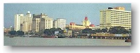 West Bengal has 18 districts and Calcutta serves as the state
capital. There are over 23 towns with over 100,000
population. The largest cities are Calcutta, Howrah,
Asansol, Durgapur and Siliguri. Other important towns
include Darjeeling, Kharagpur and Haldia. Calcutta is amongst the largest metropolitan regions in the world.
West Bengal has 18 districts and Calcutta serves as the state
capital. There are over 23 towns with over 100,000
population. The largest cities are Calcutta, Howrah,
Asansol, Durgapur and Siliguri. Other important towns
include Darjeeling, Kharagpur and Haldia. Calcutta is amongst the largest metropolitan regions in the world.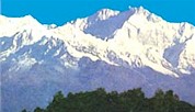


 Land use:

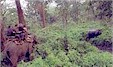
 West
Bengal is rich in flora and fauna and has a diverse ecosystems because
of its varying terrain from the high altitudes to the sea level plains. Protected
forests cover 4% of the state area. There are 15 Wildlife Sanctuaries, 5
National Parks and 2 Tiger Reserves. The Sunderban, in south Bengal, is home to the famous Tiger Project - a
conservatory effort to save the Bengal tigers from extinction. It is an
UNESCO world heritage site. Another similar project exists in Buxa in
north Bengal. Wildlife includes the Indian one horned rhinoceros, Indian
elephants, deer, bison, leopards, gaur, crocodiles and others. The state
is also rich in bird life. Migratory birds come to the state during the
winter months. For one of the best web pages on West Bengal's wildlife
check out the
West
Bengal is rich in flora and fauna and has a diverse ecosystems because
of its varying terrain from the high altitudes to the sea level plains. Protected
forests cover 4% of the state area. There are 15 Wildlife Sanctuaries, 5
National Parks and 2 Tiger Reserves. The Sunderban, in south Bengal, is home to the famous Tiger Project - a
conservatory effort to save the Bengal tigers from extinction. It is an
UNESCO world heritage site. Another similar project exists in Buxa in
north Bengal. Wildlife includes the Indian one horned rhinoceros, Indian
elephants, deer, bison, leopards, gaur, crocodiles and others. The state
is also rich in bird life. Migratory birds come to the state during the
winter months. For one of the best web pages on West Bengal's wildlife
check out the 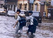 The
climate of Bengal varies according to the location. It's cooler in
the northern mountains than in the southern plains. Summers and winters
can be extreme in the mid plains. Winters are cold in the mountain
regions. The summer months are from March to June. The monsoon season
lasts from June to September and brings heavy rain. The monsoons bring
respite to the parched plains but they often cause floods and
landslides. However the importance of the monsoons cannot be
overemphasized in the Indian context. The economy of the whole nation is
dependent to a great extent on the monsoon rains. A good monsoon
means a bountiful harvest in the coming months. The winter months are from October to February. The
winter months are generally pleasant in the southern part of the state.
Snowfall is limited to the Himalayan regions.
The
climate of Bengal varies according to the location. It's cooler in
the northern mountains than in the southern plains. Summers and winters
can be extreme in the mid plains. Winters are cold in the mountain
regions. The summer months are from March to June. The monsoon season
lasts from June to September and brings heavy rain. The monsoons bring
respite to the parched plains but they often cause floods and
landslides. However the importance of the monsoons cannot be
overemphasized in the Indian context. The economy of the whole nation is
dependent to a great extent on the monsoon rains. A good monsoon
means a bountiful harvest in the coming months. The winter months are from October to February. The
winter months are generally pleasant in the southern part of the state.
Snowfall is limited to the Himalayan regions. The industrialized Calcutta and Durgapur regions have
high levels of pollution compared to other parts of the state. However
awareness about the environment is on the rise. The government, the
judiciary and NGOs are playing a positive role in this respect.
The industrialized Calcutta and Durgapur regions have
high levels of pollution compared to other parts of the state. However
awareness about the environment is on the rise. The government, the
judiciary and NGOs are playing a positive role in this respect.