Models Created by J. Karanjac

- Kharga & Dakhla Oases, Egypt, General Desert Development Organization and Industroprojekt, Zagreb, Belgrade and Cairo, (assistant to Professor Boreli) 1966-67.
- Mesa de Guanipa, Venezuela (4 models at different stages). GEOCIN, C.A., Caracas, 1972-76.
- Elazig-Uluova Plain, Turkey. DSI/UNDP, Ankara, 1977.
- Bermuda (4 fresh water lenses). Public Works Department, Hamilton, 1981-88.
- Various areas in Nepal. Ground Water Development Board and UNDP, Kathmandu, 1986-89.
- Nangong Area, China. Institute of Eng'g geology & Hydrogeology (Zhengding) and UNDP, 1983-86.
- Kasai-Suvanarekha Area, Bihar State, India. Central Ground Water Board and UNDP, Jamshedpur, 1986-88.
- Rio Guarico and other areas in Venezuela (about 10 models). Geocin, C.A., Caracas, 1977-1989.
- Salmas Area Model, Iran. Water Resources Institute & UNDP, Teheran, 1990.
- Models of Coal Mines in Yugoslavia (Drmno, Cirikovac), Mining Institute, Belgrade, 1988.
- Models of Leskovac and Vranje valleys in Serbia, Geozavod, Yugoslavia, 1989.
- Galmoy Mine Models, Ireland. Golder Associates, Inc., Atlanta, USA, 1992-93.
- Great Man-made River Project, Libya. Ground Water Authority and UNDP, Tripoli, 1994.
- Wadi Ham Model, Fujayurah Emirate, United Arab Emirates. ESCWA & BGR (Germany), Amman, Jordan, 1996.
- Waycross Model, Georgia, USA. Hazclean Environmental Consultants, Birmingham, Alabama, 1997.
- Heatcraft (Grenada) Model, Mississippi, USA. Hazclean Environmental Consultants, Jackson, Mississippi, 1997.
- Village East, Birmingham Alabama, USA. Hazclean Environmental Consultants, Birmingham, Alabama, 1997.
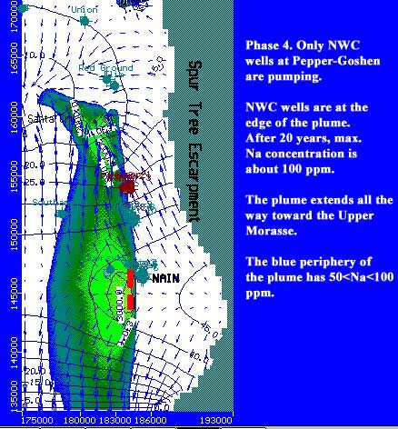
- Essex Valley karstic limestone aquifer, Jamaica, 2000. University of the West Indies.
- Bogue area, Montego Bay, Jamaica, model of injection of power plant hot waste water into Montpelier limestone formation. Jamaica, 2003.
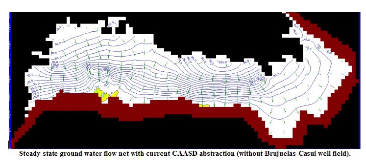
- Planicie Costera Oriental, The Dominican Republic, a preliminary model of ground water flow through karstic limestone aquifer, simulating effects of planned abstractions from the Casui-Brujuelas wellfield. 2003.
The Waycross, Heatcraft and Village East models are flow and solute transport models using the USGS MODFLOW and GeoTrans MODFLOWT software packages, respectively. The Galmoy model is a flow and contaminant fate model using Modflow (two-layers) and ASM software. The other models are flow models using either MODFLOW (single or double layer: Libya, Iran and India) or the UN GWMOD (authored by J.Karanjac). The Galmoy Mine model used ASM software for the solute component.
One of more recent model, of Essex Valley in Jamaica is made using Visual Modflow. It simulates the fate of sodium leaking into the karstic limestone from industrial ponds ("red mud"). Red mud ponds are created as a by-product of bauxite-to-alumina processing.
MOST RECENT MODELING WORK
Afghanistan, The Dominican Republic, Jamaica
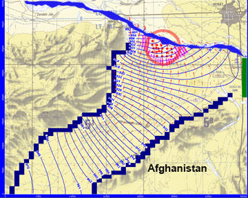
In May 2005, prepared simple models of 4 regions in west Afghanistan, the Hari Rud basin, to demonstrate the possible ground water flow pattern for monitoring network establishment purposes.